Showing posts with label Parks. Show all posts

Saturday, November 4, 2023

Grant Park Stadium was renamed Soldier Field at the urging of Chicago’s Gold Star Mothers on November 11, 1925.


Opened on October 9, 1924, Grant Park Stadium was designed by the architecture firm of Holabird & Roche. Neo-classical in style, the design pays homage to the ancient Roman Colosseum, creating a venue that exudes strength, resilience, and a sense of grandeur. The original configuration was shaped like a U, with the structure's opening facing the Field Museum. This allowed for easy access to the field and a direct view of the Field Museum for spectators.

sidebar
According to the Chicago History Museum, the stadium was never officially known as Municipal Grant Park Stadium. The name was used in some news articles and promotional materials, but it was never officially adopted by the city or the Chicago Park District (founded on July 1, 1934).

Not originally intended to be a football stadium, the idea was to create a space to host various events, including sports, military drills, concerts, exhibitions, and community gatherings, while also serving as a place of remembrance. The design was inspired by classical architecture, featuring a colonnade facade with Doric columns that encircled the stadium. The seating bowl of the stadium was initially built using a wooden grandstand, which could accommodate around 45,000 spectators.

On November 11, 1925, the stadium was renamed Soldier Field to honor the city's World War I veterans. The name change was officially dedicated on November 27, 1926, during a football game between Army and Navy.

sidebar
In 1968, Soldier Field hosted the first Special Olympics. The City of Chicago changed the address of Soldier Field to 1410 Special Olympics Drive on June 24, 2018. This was done to commemorate the 55th anniversary of the Special Olympics and to recognize the stadium's role as the birthplace of the movement.

The stadium became the permanent home of the Chicago Bears of the National Football League (NFL) in 1971.

In 1978, the plank seats were replaced with individual seats. To offer fans a better view, seats were moved closer to the field, increasing the stadium seating capacity to nearly 57,000. 


Throughout the mid-20th century, Soldier Field underwent renovations, including the construction of a grandstand in the open end of the U, the replacement of plank seating with individual seats in 1978, seats were moved closer to the field, a new press box, and the addition of more than 100 skyboxes. This increased spectator capacity to more than 66,000.

sidebar
Early  years hosted events included:
  • The 1926 Army-Navy Football Game. 
  • The second Dempsey-Tunney World Championship boxing match. 
  • The University of Notre Dame has played 13 football games at Soldier Field, including. Notre Dame defeated Northwestern 13-6 on November 22. 
  • Opening day Century of Progress ceremonies were held in Soldier Field on May 27, 1933. 
Ticket № 3. Opening Day World Fair Ceremonies at Soldier Field.

Major sporting events at Soldier Field include:
  • The January 5, 1986, NFL Divisional playoffs and the January 12 Championship games were held at Soldier Field, leading to the Chicago Bears winning Super Bowl XX against New England Patriots, 46 to 10, in the Louisiana Superdome on January 26, 1986.
  • Three 1994 FIFA World Cup Games Held at Soldier Field: 
    • June 17, 1994: The opening ceremony, emceed by Oprah Winfrey, and the opening game, featuring defending champion Germany.
    • June 21, 1994: Germany vs. Spain.
    • July 2, 1994: Germany vs. Belgium; Brazil won the 1994 FIFA World Cup.
However, the most controversial chapter in Soldier Field's architectural journey occurred in the early 2000s when the stadium underwent a major renovation. The Chicago Park District, which owns the property, faced substantial criticism when it announced plans to alter the stadium with a design by Benjamin T. Wood and Carlos Zapata of Wood & Zapata in Boston. The stadium grounds were reconfigured by local architecture firm Lohan Associates, led by architect Dirk Lohan, grandson of Mies van der Rohe.


The renovation aimed to modernize Soldier Field while preserving its historic façade. Completed in 2003, the updated Soldier Field retained its classic colonnade while incorporating a bold and contemporary design. Adding a glass and steel structure, known as the "Grand Concourse," brought a jolt of modernity to the stadium, while the two elliptical seating structures on either side of the original colonnades are striking additions to the structure.

While the innovative design allowed for enhanced amenities, increased seating capacity, and improved accessibility for fans, many preservationists, architecture critics and residents were not thrilled about the renovation. The modern additions were seen as incongruous with the stadium's neoclassical origins. "It looks like a spaceship landed." Debates about the design of the stadium continue today.

Despite the controversy, Soldier Field attracts hundreds of thousands of spectators for NFL games, athletic events, concerts and more. As the Chicago Bears look to move their home field to another location, the future of the iconic field by the lake is yet to be determined.

Compiled by Dr. Neil Gale, Ph.D.

Saturday, July 22, 2023

Schiller Woods Forest Preserve Magic Water Pump on Irving Park Road, Particulars.

The pump is located in Schiller Woods Forest Preserve in Schiller Park, Illinois, a suburb of Chicago. Google Maps: 41°57'08.8"N 87°50'38.6"W 

It was installed in 1945 to serve picnickers, just another of the hundreds of water pumps erected in the forest preserves of Cook County. 

It is a hand-operated pump that draws water from an aquifer. Many local residents believe the water has magical properties, improving health and vigor. Some believe the pump's water extends the life of anyone who drinks from it regularly, leading to the nickname "Chicago's fountain of youth." The pump is the most used of over 300 pumps maintained by the Forest Preserve Department of Cook County, necessitating yearly repairs. The pump handle was briefly removed in 1974 due to impurities but restored in 1975 after the water cleared.

There is no scientific evidence to support the claims that the water from the pump has any magical properties. However, many people swear by the water, and the pump remains a popular destination for people seeking a healthier lifestyle.

People say it has a specific taste and is unlike other waters. And it's not. It's the best water in the world! You've heard it's magic, right? I don't know if it is or if it has the rejuvenating qualities they say. But I don't try other pumps. 

It has been said that the Pope blessed it. "Holy water — that's what they call it." In 1979, Pope John Paul II visited the Northwest Side of Chicago. The Pope's motorcade drove along Nagle and Milwaukee avenues and the Kennedy Expressway and barely slowed down.

Those who swear by the Chicago's fountain of youth pump have said a lot of things: You hear it tastes better than tap water; it keeps colder for longer; it contains holistic qualities; it's good for heart and teeth; it's unfiltered and therefore not chlorinated or fluoridated; the water from this pump will keep you young an unnaturally long time.

There is no scientific evidence to support the claims that the water from this pump has magical properties.

The pump is located at the intersection of Irving Park Road and Cumberland Avenue. It is open from dawn to dusk. There is no fee to use the pump. If you're interested in visiting the pump, it's recommended that you go during the week. Remember to bring your own bottles to fill with water.

Compiled by Dr. Neil Gale, Ph.D.

Saturday, July 1, 2023

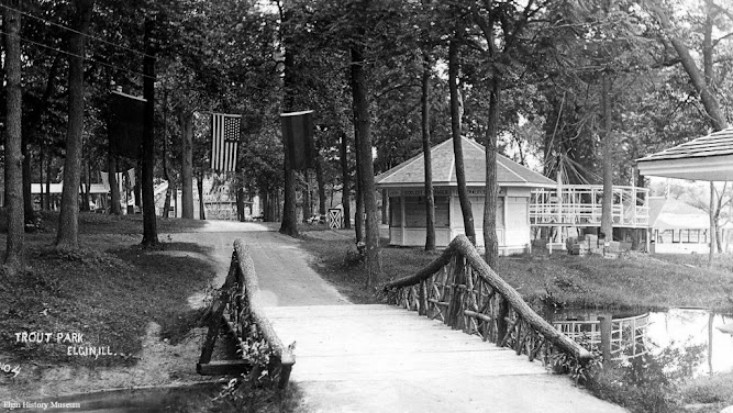
Trout (Amusement) Park, Elgin, Illinois. (1890s-1922)

Trout Park in Elgin, Illinois, has a long and interesting history. 

The park was originally owned by Dr. P.W. Pratt, who enclosed a 70-acre parcel of land known as "Cedar Swamp" and began a fish hatchery on the site in 1872. It is situated on the east side of the Fox River, 1½ miles north of Elgin.

The hatchery was successful, and the park became known as "Trout Park." In the 1890s, the park was also home to an amusement park, which featured a variety of rides and attractions.

The park became a popular resort for pleasure seekers, especially Germans from Chicago. In 1895, the city of Elgin purchased the park and opened it to the public.


In the early 1900s, Trout Park was home to an amusement park, a botanical garden, and the Trails & Treasures Tea Room. The amusement park featured a carousel, a roller coaster, and other rides. The botanical garden was filled with various plants, including rare white cedar trees. The Trails & Treasures Tea Room featured a wall of windows with a view of the river and was a trendy spot for afternoon tea.

In 1910, Trout Park became home to Elgin's first semi-professional baseball team, the Elgin Kittens. The Kittens played their home games at a stadium in the park that could seat 3,500 spectators. The team played in the Northern Association, a minor league baseball league, from 1910 to 1912.

Trout Park remained a popular destination for Elgin residents throughout the 20th century. 

The park was designated an Illinois Nature Preserve in 1972 due to its rare white cedar trees and other natural features. Today, the park is still popular for hiking, fishing, and picnicking.

Compiled by Dr. Neil Galew, Ph.D.

Monday, May 1, 2023

May is Asian American and Pacific Islander (AAPI) Heritage Month.

This year (2023) marks the 44th anniversary of celebrating Asian American and Pacific Islander (AAPI) Heritage. 

The original observation was seven days beginning on May 4, 1979, as Asian Pacific American Heritage Week passed by the U.S. Congress and signed into law by President Jimmy Carter on October 5, 1978. 


President George H.W. Bush extended the celebration for the entire month on May 7, 1990, and designated it Asian Pacific American Heritage Month in Proclamation № 6130.

It is difficult to identify the "first" Asian in frontier Illinois since the history of Asians in Illinois' footprint dates back several centuries and is complex. However, it is known that Asians, particularly the region's indigenous peoples, have lived in what is now Illinois for thousands of years. 

sidebar
Illinois is the sixth largest state with 828,847 (2020 Census) Asians. California is home to 6,764,118 Asians, followed by New York with 1,884,346, and Texas comes in third with 1,656,166 Asian residents.

The first recorded Asian immigrants to Illinois were likely Chinese workers who helped build the transcontinental railroad between 1863 and 1869. It is also important to note that many Asians, mainly of South Asian descent, were brought to Illinois as indentured servants or slaves during the colonial era.

The first group of Japanese in Chicago arrived in 1892 with jobs and skills to build the Ho-o-den Pavilion at the World's Columbian Exposition.
Ho-o-den Pavilion at the 1893 Chicago World's Columbian Exposition.


Kamenosuke Nishi was the first known (documented) Japanese individual in Chicago. He relocated from San Francisco, California, in 1893 and opened a Gift Shop at 27th Street and Cottage Grove Avenue. Nishi parlayed his vision and honed his sales and management skills into $700,000 in profit.

sidebar
Today, Cottage Grove Avenue's north terminus is at 33rd Street, which heads only eastbound.

In the early 1900s, about 400 Japanese immigrants lived in Chicago. After WWII, the U.S. Government resettled 20,000 Japanese families or individuals to Chicago from World War II internment camps.

Because the Japanese did not emigrant to Chicago on their own, that alone denied them the opportunity to develop their unique neighborhood and identity, as Chinatown, Little Italy, Greek Town and other Chicago ethnic neighborhoods did.

Compiled by Dr. Neil Gale, Ph.D.

Tuesday, April 26, 2022

Lincoln's Connection to Camp Kane, Civil War Training Camp, St. Charles, Illinois.


John Franklin Farnsworth was a resident of St. Charles. He was an attorney, founder of the Republican Party, congressman, as well as a personal friend of Abraham Lincoln. In 1858, he advised Lincoln during the famous Lincoln-Douglas debates, and in 1860 nominated Lincoln for president during the Republican Party Convention. Farnsworth was also called to the bedside of the dying President at the Petersen House after Lincoln was shot at Ford's Theatre in 1865. 
John Franklin Farnsworth


Without Farnsworth's influence, Camp Kane would not have been so successful. Farnsworth had no problems in fulfilling the 1,200-man quota. Approximately one in six men from St. Charles served in the regiments. Recruits also came from as far as Indiana, Iowa, and Michigan.

After the Civil War began, Farnsworth requested permission from his friend, President Lincoln, to commission a volunteer cavalry regiment and train them in St. Charles, Illinois, on property Farnsworth owned. The commission was approved on August 11, 1861. Abraham named the new regiment "Farnsworth's Big Abolitionist Regiment." Farnsworth was promoted to Colonel.

Camp Kane officially opened for training on September 18, 1861, with 1,164 men who mustered in. It was the only Civil War Training Camp in Kane County that became home to the 8th Illinois Cavalry and later the 17th Illinois Cavalry. 

In February 1864, extensive barracks were built on the Lovell property, in the north part of the city, which received the designation of Camp Kane, and in February 1864, these were temporarily occupied by the Fifty-second Regiment, then at home for a short time. The regiment received large accessions from the place on a redeparture for the front in March of the same year, and in the June following the One Hundred and Fortieth Illinois Volunteers, marched from Camp Kane. Elgin contributed two companies to the regiment. Besides these mentioned, Elgin contributed many soldiers to other organizations, and from the day, in the early spring of 1861, that the first company left it, until the happy midsummer, four years after, that the war's last veteran marched proudly home, Elgin was never derelict to the calls of the struggling, but at last victorious republic.

Colonel Farnsworth was close friends and political allies with Joseph Medill, Chicago Tribune Editor, and co-owner. Medill was also an abolitionist and used the Tribune for the cause. Once approval was granted to form the 8th Illinois Cavalry, Medill promoted recruiting in the Tribune. Even William Medill, Joseph's brother volunteered. 

Despite its size, St. Charles gave one of the largest quotas of troops in all of Kane County. St. Charles residents such as General Farnsworth, Captain Elliott, Major Van Patten, Major John Waite, Captain Beach, Captain McGuire, Colonel Gillett, Major (Judge) Barry, Lieutenant Durant, and Dr. Crawford all aided in the war effort. These names are among the most important in the history of St. Charles..
Following the war, men of the 8th Cavalry continued to serve their country. In April 1865, they took part in the search for Abraham Lincoln's assassin, John Wilkes Booth, and also guarded the President's body.
Located on the east bank of the Fox River, Camp Kane, Civil War Training Camp, St. Charles, Illinois.


The 8th Illinois Cavalry's honors included battles such as Mechanicsville, Antietam, Fredericksburg, and most notably Gettysburg, where it was the 8th Illinois Cavalry's Lt. Marcellus Jones who fired the first shot of the famous battle. Confederate Colonel John S. Mosby "The Grey Ghost" called the 8th Illinois Cavalry "The best cavalry regiment in the Army of the Potomac." On a more sorrowful note, the 8th Illinois Cavalry also had the disheartening yet distinguished honor of being the honor guards for  Lincoln's funeral train.  
A Reenactment Photograph.


General Farnsworth and Colonel John Beveridge commissioned the 17th Illinois Cavalry in early 1863. Most of their service was in Missouri. They trained at Camp Kane in the early months of 1863 and Camp Kane remained an active training camp until early 1864.

Visit Camp Kane at Langum Park at 999 South 7th Street, St Charles, Illinois.

Compiled by Dr. Neil Gale, Ph.D.

Sunday, February 28, 2021

The Prehistoric Old Stone Fort, Saline County, Illinois.

The Stone Forts of Illinois.
One of the unique prehistoric phenomena of Southern Illinois is the ruins of stone walls which have traditionally been known as "stone forts." They appear in the rough east-west alignment across the hill country and appear to form a broken chain between the Ohio and Mississippi Rivers. These ruins have similar geographic site characteristics. They are generally located on bluffs, which are often finger-like promontories of land with steep cliffs on three sides and a gradual incline on the fourth. It was across these inclines leading to the top of the bluff that these stone walls are most generally located, hence the theory of a pound or game trap, has been advanced.

Many of the walls have long been torn down and removed for building purposes. Early settlers, in most instances, removed the better slab-like stones for building foundations, leaving only the rubble. These early white pioneers saw the walls and thought of them in terms of their own experiences, particularly from the standpoint of defense against the Indians. Though they called them stone forts, these sites would be very poor places to carry on prolonged fights.

If a small band took refuge behind the wall, they might be pushed over the cliff by a larger attacking force. Or a larger force could lay siege to the place, and the band would be cut off from both food and water and soon starve to death. Although they called them "forts," many people did not accept such a theory, and speculation continued.

Archaeologists believe that particularly in Ohio, the Hopewellian Indians probably were responsible for some of the walls, but the identity is not known. These walls represent a major accomplishment for a people who had only primitive digging implements and methods of carrying or moving heavy stones. These unknown builders piled rock completely across summits, leaving inside enclosures sometimes as large as 50 acres, depending upon the size of the bluff.
The Old Stone Fort in Southern Illinois lies between the Ohio and Mississippi Rivers.


Another fort built almost exactly as the Makanda Fort is the fort that lies southwest of Carrier Mills in Saline County. The old fort site is found four miles east of the present town of Stonefort in Williamson County and seven miles east of Creal Springs, Illinois. Its area is almost the same as Makanda's Fort and research into the Archivo General de Indias at Seville, Spain (the repository of extremely valuable archival documents illustrating the history of the Spanish Empire in the Americas) shows that such a fort was spoken of by DeSoto in 1542. 


This old fort is on top of a hill, which is almost inaccessible. The walls are constructed of large stones and the whole reminds one of the ruins of a once well-constructed fortification. It has gone to ruin more or less within the past one or two years. The first house in the vicinity was one built in 1831 by J. Robinson. The village of Stonefort is situated atop a ridge that rises above the South Fork Saline River valley to the north and the Little Saline River valley to the south. The village of Stonefort was established in late 1858 and was originally located about a mile to the southeast, near the edge of the bluff. There were houses there earlier. 
Some scholarly visitor named the ruins Cyclop Walls, but most people simply call it old Stone Fort.


When the Cairo and Vincennes Railroad was completed through the area in the 1870s, Stonefort's public buildings were dismantled and moved to the village's present location, which was adjacent to the railroad tracks. The former site of the village is now listed as "Oldtown" on maps which is 1.8 miles northwest of Stonefort.

Compiled by Dr. Neil Gale, Ph.D.
Sunday, January 3, 2021

A Replica Lincoln Statue is Removed in Boston, Massachusetts. The Original Statue Remains in Washington D.C.


In historical writing and analysis, PRESENTISM introduces present-day ideas and perspectives into depictions or interpretations of the past. Presentism is a form of cultural bias that creates a distorted understanding of the subject matter. Reading modern notions of morality into the past is committing the error of presentism. Historical accounts are written by people and can be slanted, so I try my hardest to present fact-based and well-researched articles.

Facts don't require one's approval or acceptance.

I present [PG-13] articles without regard to race, color, political party, or religious beliefs, including Atheism, national origin, citizenship status, gender, LGBTQ+ status, disability, military status, or educational level. What I present are facts — NOT Alternative Facts — about the subject. You won't find articles or readers' comments that spread rumors, lies, hateful statements, and people instigating arguments or fights.

FOR HISTORICAL CLARITY
When I write about the INDIGENOUS PEOPLE, I follow this historical terminology:
  • The use of old commonly used terms, disrespectful today, i.e., REDMAN or REDMEN, SAVAGES, and HALF-BREED are explained in this article.
Writing about AFRICAN-AMERICAN history, I follow these race terms:
  • "NEGRO" was the term used until the mid-1960s.
  • "BLACK" started being used in the mid-1960s.
  • "AFRICAN-AMERICAN" [Afro-American] began usage in the late 1980s.

— PLEASE PRACTICE HISTORICISM 
THE INTERPRETATION OF THE PAST IN ITS OWN CONTEXT.


A replica of a controversial statue of Abraham Lincoln standing over a newly emancipated Black man—the figure modeled on Archer Alexander, the last man recaptured under the Fugitive Slave Act—has been removed from Park Square in Boston, Massachusetts. The original statue in Washington's Capitol Hill neighborhood at Lincoln Park was also criticized over the summer during demonstrations following the police killing of George Floyd on May 25, 2020.


Officials placed the statue under police guard and surrounded it with protective barriers after a group of demonstrators tore down a statue of former Confederate Albert Pike a few blocks away and threatened to do the same with the Lincoln statue.

The statue by Thomas Ball depicts a shirtless Black man, on his knees, in front of a clothed and standing Abraham Lincoln. Ball called his artwork "Emancipation Group." On the one hand, Lincoln holds a copy of the Emancipation Proclamation, while the other arm is stretched over the Black man. Ball intended it to look like the man was rising to freedom, but to many, it seems like he is bowing down or supplicating to Abraham Lincoln.

Archer Alexander, who modeled for Ball, was not initially freed by Lincoln but by his actions. He escaped his bondage in the middle of the night in 1861 and repeatedly evaded capture by his former enslavers.
A statue of Abraham Lincoln and a formerly enslaved negro man has been taken down in Park Square in Boston, Massachusett, after an intense debate and a petition to remove the work.


Boston Museum founder Moses Kimball donated the bronze recasting of the original Ball statue in Washington, D.C., to Boston in 1879. The replica will be temporarily stored while the city figures out "a new publicly accessible location (i.e., a museum) where it could be better explained."
The Emancipation statue was driven away on a flatbed truck after it was removed from its location in Park Square in Boston, Massachusetts, on December 29, 2020.


The Emancipation Memorial statue was commissioned and paid for by a group of Black Americans, many formerly enslaved. But the group did not have a say in the statue's design; that distinction went to an all-White committee and the artist, Ball, who was White.

The original statue was dedicated on April 14, 1876, the 11th anniversary of Lincoln's assassination, before a crowd of 25,000 that included then-President Ulysses S. Grant. Abolitionist Frederick Douglass spoke at the unveiling, noting that the "Great Emancipator," Lincoln was reluctant to free enslaved people. When he did so, it applied only to enslaved people in Confederate states, and enslaved people in most Union states were not freed until December 1865.

Days after the unveiling, Douglass was the first to criticize the monument and suggest an additional memorial be placed in the same park to better represent negroes, in a letter to the editor of the National Republican Newspaper.

The letter below, written by Frederick Douglass in 1876, was published in the National Republican Newspaper just days after the monument ceremony in Washington, D.C.


A Suggestion.

To the Editors of the National Republican:

Sir, 

Admirable as is the monument by Mr. Ball in Lincoln Park, it does not, as it seems to me, tell the whole truth, and perhaps no one monument could be made to tell the entire truth of any subject which it might be designed to illustrate. The act of breaking the negro's chains was the act of Abraham Lincoln and is beautifully expressed in this monument. 

But the act by which the negro was made a citizen of the United States and invested with the elective franchise was pre-eminently the act of President Ulysses S. Grant, and this is nowhere seen in the Lincoln monument. The negro here, though rising, is still on his knees and nude. What I want to know before I die is a monument representing the negro, not the couchant (body resting on the legs/knees and the head raised) on his knees like a four-footed animal, but erect on his feet like a man. There is room in Lincoln Park for another monument, and I throw out this suggestion so that it may be taken up and acted upon.

Frederick Douglass                   


Compiled by Dr. Neil Gale, Ph.D.

Wednesday, December 2, 2020

The History of Thillens Stadium, Little League Baseball Park in the West Rogers Park Neighborhood of West Ridge Community of Chicago.

The "North Town Currency Stadium" at 6404 North Kedzie Avenue was founded in 1938 by Mel Thillens, Sr., owner of the Thillens Checashers business at 2351 West Devon Avenue, just east of Western Avenue. Thillens idea was to have a baseball park that anyone could use, rent-free. Well. . . It cost Mel Thillens $6 million to build the park to his satisfaction.
Thillens Stadium was initially named North Town Currency Stadium.


Thillens Stadium was north of the Lincolnwood diner and past the CTA bus terminus turn-around for the 155 bus route. Next came the parking lot for the Stadium, which was small, perhaps only 30 cars and another 20 cars along the eastern fence on Kedzie Avenue.
3200 Devon Avenue, Lincolnwood, IL. Sandwich and homemade ice cream shop.


On the EAST side of the North Shore Canal, at the northwest corner of Devon and Kedzie Avenues, was the 'Lincolnwood Dairy" at 3200 Devon Avenue, Lincolnwood, IL. Sandwich and homemade ice cream shop. Then came the 'Lincolnwood Coffee Grill and Fountain Shop.' The location is in Chicago Today.


Tessville, Illinois,
was renamed "The Village of Lincolnwood" in 1936. 

BORDER CHANGE
The Lincolnwood border was moved west from Kedzie Avenue's west side to McCormick Boulevard's west side in 1940.

In 1940, the ballpark erected lights for night use. In the 1940s, 1950s, and 1960s, both Little League games and men's 16-inch softball games were televised from the park by WGN-TV (Channel 9), with Jack Brickhouse announcing.
Entrance to the overflow parking lot on Kedzie Avenue, north of the Stadium at Arthur Avenue.


North of the 2nd baseball diamond was a large, free, gravel parking lot on the east side of the North Shore Canal. 

During a Little League telecast in the 1950s, the centerfield camera, now a staple of all baseball telecasts, was first used. Brickhouse said, "One of our cameramen, Chuck Seatsema, told me that the centerfield scoreboard was only a couple hundred feet away. He felt that if he put a camera out there, we'd get a nice shot of the little catcher giving signs and the little batter's face over the pitcher's shoulder."
"The Bases Are Loaded."
Thillens Stadium, Devon & Kedzie, Chicago, Illinois. 1953 
[runtime: 00:27:09]


An area landmark was the giant baseball named Thillens on a large pole in the front of the ballpark. Initially, the ball spun on the pole. The Thillens baseball sign began as a globe spinning on top of the "Boys' World" clothing store at  2516 West Devon Avenue, at Maplewood, which used to be the Cine Theatre from 1937 to 1953. Mel Thillens bought the globe when Boys' World closed in the 1950s, and Mel had a parade moving the globe west on Devon Avenue to Kedzie Avenue. 

The Thillens family took great pride in the spit-and-polish glamour associated with Thillens Stadium. The landscaping, cleaning, and painting all contributed to the sense that you were in a shrine, spending $100,000 a season for expenses and over $100,000 yearly maintenance to keep the place up.
Mel Thillens Sr. and Jr. in front of their currency exchange on Devon Avenue, 1977.


The centerfield scoreboard contained a 6-by-8-foot picture of the Thillens armored truck. Starting in 1974, if any player hit the truck on the sign, they would win a $5,000 savings bond. Only three talented little leaguers hit the armored truck at the top of the scoreboard, hitting a baseball 300 feet.

Amazingly, all three batters accomplished the feat on the same date: September 2. Al Pulikowski of Villa Park and Art Eggert of Elk Grove hit it in 1984, only 52 batters apart. Five years later, Patrick Patterson of Des Plaines became the third winner, hitting the truck on September 2, 1989.
Mel Thillens, Sr. died on December 20, 1993, but his family continued to operate the field, and a non-profit charitable foundation supported it. Over time, the foundation could not afford expenses, and in March 2005, Thillens Stadium closed. 

The city of Chicago and the Chicago Cubs combined to invest $1.5 million in repairs, and the Stadium reopened its doors in June 2006. The larger of the two diamonds, the one on the park's south side, was named "Cubs Field." The park has since been renamed "The Stadium at Devon and Kedzie."
The Stadium at Devon and Kedzie Entrance.


In 2013, the Thillens family requested that their family name be removed from the field. Mel Thillens, Jr. was quoted as saying the field wasn't being maintained, and the Thillens family and business no longer wanted to be associated with it. The Chicago Park District claimed to have maintained Thillens to "continue as a place of historical significance" that "thousands of children enjoy" yearly. They obliged Mr. Thillens' request, removing the name from the field. In June of 2013, the 60+-year-old giant baseball, estimated 12 feet in diameter, was removed because it was deemed unsafe.

RAY RAYNER AND I TALKED FOR MORE THAN 2 HOURS
I met Mel Thillens at his business office of the "Thillens Armored Car Check Cashing Company" on Devon Avenue, just east of Western Avenue. I just walked in and asked to speak with Mr. Thillens in the spring of 1968; I was 8 years old. Mel Thillens stepped out of his office to greet me. He took me into his office. 

I asked him if I could work at Thillens Stadium for the season. Mel asked me a few questions to determine my interest in working at the Stadium. Mel gave me a day and time to meet him at the Stadium. He introduced me to the staff, telling them that I'd be helping them out.

I was allowed to attend any and all games I wanted to for free. When working, I was allowed to eat, drink, and snack for free. As a matter of fact, I don't remember there being any limit to food and drink. Sounds good. Although I didn't get any money, I met some local celebrities, like Ray Rayner, Eddie Feigner and his team, the King and his Court, the Queen and her Court, the Donkey Baseball teams, etc.

I met Ray Rayner at Thillens Stadium in 1968. Ray was on a WGN 16" softball team playing the Playboy Bunnies. The evening game was for a charity. It was standing room only. 

If you know anything about Thillens Stadium, one kid worked the manual scoreboard, placing the number of runs per inning and a total runs count. The Strikes, Balls, and Outs scoreboard lights were worked from an elevated platform, with the game announcer from behind the home plate. I worked the strikes and outs from the announcer's booth.

Ray sat in the announcer's booth when the WGN vs.Playboy Bunnies game ended. We talked for quite some time. Ray told me he would speak of the charity softball game on his show on Monday. I jokingly mentioned that I never heard my name called on the Romper Room Show. Rayner told me he would say my name on his TV show the next day, and I could count on him. 

Sure enough... Ray talked about the charity softball game and how much money was raised, and then he said he met a great kid who worked at Thillens Stadium, Dr. Neil Gale. I was floored. It's too bad there were no recording devices to capture that, but it's one of my life's "claim to fame" moments.

Mel Thillens had my name put up on the sign that same day. I couldn't believe it when Mel gave me the picture he had taken the following day. I'm Facebook friends with two of Mel's daughters.


THE URBAN MYTH OF RAY RAYNER BEING A DRUNKARD - BUSTED!
I watched Ray Rayner test his blood sugar after the softball game mentioned above while sitting next to me in the announcer's booth at Thillens Stadium in 1968. You don't do that unless you're diabetic, so getting drunk EVERY night is just ridiculous. It also besmirches Ray's reputation.

sidebar
In 1932, Mel Thillens owned and operated a currency exchange at 2351 West Devon Avenue in Chicago. His clientele mainly consisted of factory workers and government employees in the Works Progress Administration (WPA) program from 1935-1943.
           
To eliminate customers from tracking mud over his new office carpet, he conceived the idea of bringing money to the workers to cash their paychecks. It was the first mobile armored car check-cashing service in the U.S.

Copyright © 2020 Dr. Neil Gale. All rights reserved.


An Early Thillens Checashers Armored Truck.


Monday, November 9, 2020

The Complete History of the Fort Lincoln Cemetery Property in the Town of Colmar Manor, Maryland.

The History of the Town of Colmar Manor, Maryland
In 1632, George Crawford was given a tract of land in the area by King Charles I of England. Crawford's son, Cecelius, who was also known as the second Lord Baron of Baltimore, took possession of the land after his father's death and encouraged settlement upon it. Exactly who settled there at that time is uncertain, although the land on which Fort Lincoln Cemetery is situated was part of the original grant from Lord Baltimore to George Conn and remained in the Conn family for more than 200 years. It is believed that a Spring House was erected on the Conn land-grant in 1683 (discussed later in the article), making it one of the oldest structures in Maryland.

By the late 1700's Bladen'sburg, which included some land on the west side of the Anacostia River, was a thriving port town. 
In the early 1800s, the Baltimore and Washington Turnpike (Bladensburg Road) offered easy access from Washington to Bladensburg and beyond. On August 24, 1814, British troops advancing toward Washington, D.C., met resistance from American forces under the command of Brig. Gen. William H. Winder. The subsequent dash resulted in the American troops making a hasty retreat toward Washington D.C. Commodore Joshua Barney and a contingent of Marines and sailors fought a rearguard action on the heights (now the Fort Lincoln Cemetery) of what is now the Fort Lincoln Cemetery. Barney was wounded and captured. Many soldiers on both sides were killed on the battleground around Bladensburg and what is now Colmar Manor.

By 1861, it was another war that brought military forces to the area. During the Civil War, the land that is now Colmar Manor belonged in part to the Shreve Estate. It was there and on the same heights where Commodore Barney had unsuccessfully fought the British 47 years earlier that Union forces constructed a fort to serve as apart of the Ring of Civil War Union Forts to defend the City of Washington, D.C. 

Because Abraham Lincoln visited the heights often and partook of the cold water from the Old Spring House, the fort was named Fort Lincoln. During the war, the 3rd Massachusetts Heavy Artillery Battalion and Company E of the 4th Colored-troops reportedly encamped in and around the fort.

Fort Lincoln Cemetery, Colmar Manor, Maryland
There are three historically significant spots located on the Fort Lincoln Cemetery property. The first is one of the oldest colonial-era structures in the state of Maryland, the Old Spring House. The second is the location of the Battle of Bladensburg during the War of 1812 which is located in the cemetery marked by a plaque. And the third historical spot is the Civil War defense, Fort Lincoln, an earthworks fortification marked today with cannons. 

The Old Spring House
The Spring House, built on the spot of a natural spring, is the oldest standing building on the cemetery property and maybe the oldest structure still standing in Maryland. Tradition says a Spring House was erected on the George Conn property in 1683, however, the Spring House was probably not constructed until around 1765 after one of Conn's kin actually bought the land.
The Spring House is reportedly one of the oldest buildings still standing in Maryland.
The Spring House served two purposes, first to keep leaves and dirt away from the spring water, which was sometimes thought to have healing powers, and to keep milk, butter, and other dairy products cool. The cool spring water was fed into a trough inside the structure—in this case just 300 square feet—where it cooled the air. The thick stone walls kept heat from escaping.

President Abraham Lincoln visited the heights (now the Fort Lincoln Cemetery) often meeting with troops to discuss strategy, sitting under the old oak tree, and drinking the cold water from the Spring House.

Today, the spring still feeds cool water through the inside of the Spring House.

The Location of the Battle of Bladensburg during the War of 1812
The Battle of Bladensburg was fought in Maryland on August 24, 1814, and this British victory left Washington D.C. perilously open to the British invasion. The embarrassing defeat of American forces under General William Winder allowed British Army Officer Robert Ross’ men to subsequently march into nearby Washington D.C. and set fire to public buildings, including the presidential mansion (later to be rebuilt and renamed as the White House) over August 24th and 25th. Devastating American morale by destroying the very symbols of American democracy and spirit, the British sought to swiftly end an increasingly unpopular war.

Though neither side had gained a clear advantage in the first two years of the War of 1812, that changed in the spring of 1814 when Britain was able to disentangle itself from fighting France in the Napoleonic Wars. After Napoleon’s exile in April 1814, British forces could be replenished with thousands of veterans. These soldiers were different than the soldiers Americans had faced in Upper Canada; these men had fought against Napoleon and his Imperial Guard and wanted a quick end to this war against a young country.  

British military leaders drew up a plan to decisively end the war, crafting a strategy to take control of the New England states and focus an attack on New Orleans, thereby separating north and south by cutting off critical transportation routes in both regions. In addition to destroying American trade, the British also planned to degrade American morale by arranging attacks on coastal cities such as Washington, Baltimore, Charleston, and Savannah.

With this in mind, General Robert Ross arrived in Maryland, fresh from the Napoleonic Wars. Despite having recently been wounded in February at the Battle of Orthes, Ross returned to take charge of British troops on the east coast. Ross marched his 4,500 men from Benedict, Maryland towards Washington, D.C. with a goal of weakening American resolve.

American General William Winder organized his forces, believing that Washington, D.C., and Baltimore would need to be defended. Because Bladensburg, just northeast of D.C., was key to both Washington and Baltimore’s defense, Winder deployed across the roads that led into the young nation’s capital. Though Winder had around 6,500 men at his disposal, most of his men at Bladensburg were poorly trained militia and their resolve would crumble in the face of the war-weary British. 

Though Americans positioned themselves well against an attack with artillery covering a bridge over the eastern branch of the Anacostia River, they were overwhelmed when the British attacked at noon on August 24th. Fording the river above the bridge and beating back troops who defended the bridge, British General Ross’ 4,500 men steadily advanced against American artillery and rifle fire, gaining control of the west bank. Under heavy British pressure, the left flank of the American line of defense crumbled. As the left flank was enveloped, Americans fled the scene. Their general, Winder, had not prepared a plan for American retreat and his panicked men ran from the battle instead of maneuvering in a controlled retreat to defend Washington D.C. against the impending attack. With American forces scattered, the road to America’s capital was now wide open.

As the British marched into Washington in 1814, they held in their memory the bitter date of April 27th1813—the day Americans had burned of the Canadian capital, York. They carried vengeful appetites as they entered Washington, D.C. the evening of August 24, 1814.

President Madison and his cabinet had fled the city, Dolly Madison and White House slave Paul Jennings famously saving critical relics of their new republic, among them a portrait of George Washington. It was a good thing that the first lady and Jennings saved these symbols of American democracy as British forces wasted no time in setting the presidential mansion, the Capitol, the Treasury, and the War Office ablaze in the evening of August 24th.

The embarrassing defeat at Bladensburg, coupled with the destruction of Washington, D.C., depleted American morale. For both sides, the Battle of Bladensburg helped usher in a conclusion to a costly and frustrating war.
Detailed Map of the Battle of Bladensburg on August 24, 1814.
CLICK TO VIEW IN FULL-SIZE
The burning of Washington went down in history as the only foreign attack on the nation’s capital until the terrorist attacks on September 11, 2001. 

The cemetery property was an active part of the Bladensburg Dueling Grounds until 1820. 

The Bladensburg Dueling Grounds
The general reason for dueling was almost always the same–a man in public life felt that his honor and ability to command respect in public life had been impugned, leading him to believe that the only way to defend this reputation was to challenge his antagonist to a duel. 

A small creek meanders toward the Anacostia Riveron the north side what is now the Fort Lincoln Cemetery. The creek is sandwiched between two hills and was lined with many trees. It was along this creek, according to various accounts, that “gentlemen of the area have settled their political and personal differences since 1732."

The Dueling Grounds, as the area came to be known, is a small spit of land, a fraction of its original size, along Dueling Creek, formerly in the town of Bladensburg, Maryland, and now within the town of Colmar Manor, just to the northeast of Washington, D.C. Dueling Creek, formerly known as '"Blood Run" and "The Dark and Bloody Grounds," was a tributary of the Anacostia River, which used to be called the East Branch Potomac River.
Ravine at Bladensburg, Maryland, famed for fatal duels. 1904
One-half of a stereograph card.
From 1808 the grove witnessed approximately 50 duels by gentlemen, military officers, and politicians, settling "affairs of honor." A formalized set of rules and etiquette, called "the code duello" was usually enforced by the duelers and their seconds. The exact number of duels and the names of all the participants who fought at the Bladensburg Dueling Grounds may never be known because surviving records are obscure, the events are not well documented, and, dueling was illegal. Following the Civil War, dueling fell out of favor as a means of settling personal grievances and declined rapidly; the last known duel was fought there in 1868.

One of the most famous disputes of the 19th century was between Commodore Stephen Decatur and James Barron, which was settled there on March 22, 1820. Decatur, who had gained prominence during military operations against the Barbary Pirates off of North Africa in the early 1800s, and Barron, who had lost his command by a court-martial in 1807 and was stripped of his Commodore title, had been feuding for over 13 years. After exchanging angry letters and insults during that time, Barron finally challenged Decatur to a duel. 

The code of the duel required that the combatants be accompanied by friends, known as seconds. The seconds arranged for the duel's location and the form of the duel, which included the choice of the weapon. On March 22, 1820, Barron brought a set of 50 caliber Holmes Percussion pistols to Bladensburg; however, the seconds decided to use Decatur’s instead. Both men were wounded, Decatur, the U.S. naval hero, later died at his home in Washington D.C.
The Antique Stephen Decatur Dueling Pistols.
The Union Civil War Fort Lincoln (1861-1865)
By 1865 the Ring of Civil War Union Fort defenses of Washington D.C. was said to include some 68 named fortifications, 93 detached batteries, 20 miles of rifle pits, blockhouses at three key points, and 32 miles of military roads. At the beginning of the civil war, there was only Fort Washington, a single fort protecting the city. Click to read the Fort Lincoln article.

The Fort Lincoln Cemetery
Fort Lincoln Cemetery was chartered in 1912 by an act of the Maryland General Assembly. The first burial occurred in 1921. The 176-acre property was historically significant long before it became a cemetery. 
Grounds at Fort Lincoln Cemetery.
The property was an active part of the Bladensburg Dueling Grounds until 1820. Fort Lincoln an earthworks fortification was established in 1861 to help protect Washington D.C.
Fort Lincoln Cemetery Garden of Ascension.
Horace W. Peaslee designed Fort Lincoln’s Little Church, which was built in 1929. The church, designed in the form of a cross, contains eight stained-glass windows portraying the “Seven Ages of Man,” as depicted in Shakespeare’s play “As You Like It.” The rear cloister of the church contains individual or family vaults for those who prefer entombment. There is a small bell tower with a bell to the left of the junction of the cross. The sanctuary, with its manual organ, serves for baptisms, weddings, anniversaries, Sunday concerts, and funerals. The lower chamber of the church is the crematorium. The Little Church building won an architectural award from the Board of Trade.
Fort Lincoln Cemetery Little Church.
At the cemetery entrance, a floral clock was built in 1938. The clock contains a face of 32 feet in diameter, of which 28 feet is planted surface. It runs using a highly accurate Seth Thomas electronic timekeeping mechanism. The numbers are 21 inches high and 12 inches wide. The minute hand weighs 300-350 pounds and is 18 feet 4 inches in length. The hour hand weighs 200-250 pounds and is 14 feet 9 inches long.
Fort Lincoln Cemetery Floral Clock.
At the original entrance is an old gatehouse and office. The gatehouse was built in 1919, was designed by Horace W. Peaslee. The gatehouse was torn down after 1978 to build the Fort Lincoln Funeral Home. The administration building was built in 1972 near the newer cemetery entrance.
Fort Lincoln Cemetery Tranquil Oaks Cremation Garden.
The Community Mausoleum was built in 1947 and sits just behind the Little Church. A wing was added in 1952, which has a small 100 seat chapel. Above the front entrance is a beautiful carving that depicts the Biblical story of Abraham entombing his wife, Sarah. The stained-glass windows of the chapel include colorful scenes from Arthurian literature and the "Quest for the Holy Grail." Other stained-glass windows through the mausoleum were created by Henry Lee Willet, and depict Christian stories and children’s poems. Opposite the second floor entrance is a monument made of Indiana limestone commemorating the August 24, 1814 Battle of Bladensburg stand by the Marines under the command of Commodore Joshua Barney. 

The Liberty Bell
Near that mausoleum sits a 1976, Bicentennial, replica of the Liberty Bell. The Liberty Bell at Fort Lincoln Cemetery is a half-size (22¼" diameter, 23½" height, and weighs 290lbs) Christoph Paccard Bell Foundry replica that was cast in 1976. The foundry, now in its seventh generation, began in 1796. The 1976 replica bells can be distinguished from the 1950 bells by their ornamental surface crack and lack of a serial number.
NOTE: The original Liberty Bell is located in the Liberty Bell Center in Independence National Historical Park, Philadelphia, Pennsylvania. Although no immediate announcement was made of the Second Continental Congress's vote for independence—and so the bell could not have rung on July 4, 1776, related to that vote—bells were rung on July 8 to mark the reading of the United States Declaration of Independence. While there is no contemporary account of the Liberty Bell ringing, most historians believe it was one of the bells rung on the 8th. After American independence was secured, the bell fell into relative obscurity until, in the 1830s, the bell was adopted as a symbol by abolitionist societies, who dubbed it the "Liberty Bell."
The Liberty Bell at Fort Lincoln Cemetery is a half-size (22¼" diameter, 23½" height, and weighs 290lbs) Christoph Paccard Bell Foundry replica that was cast in 1976.
District of Columbia-Maryland Boundary Markers Map
A 1790 Act established that 40 boundary markers be placed at the District of Columbia-Maryland line to set aside land as the seat of government. The survey was begun by Major Pierre Charles L’Enfant and completed by Major Andrew Ellicott. After the Virginia sandstone markers were placed in 1792, a variation in the original land survey was detected to discover the Northeast Number 7 boundary stone was wholly on Maryland land. 
Boundary Stones Map of Washington D.C.
The Daughters of the American Revolution placed an ornamental iron fence around this stone and others around 1916 to protect them from damage.
Boundary stone in a protective cage, the early 1900s.
The older half of Fort Lincoln Cemetery contains traditional grave sites with headstones and a few private mausoleums. The newer sections are laid out according to the memorial park concept. Here, religious and historical gardens contain markers set flush to the earth.

The Battery Jameson Civil War Fortification
A 190-foot section of Battery Jameson, a Civil War fortification built-in 1862, still stands on the Fort Lincoln Cemetery grounds. The cannons that were originally installed in the fort are no longer there, but 12-pound boat howitzers designed by John Adolphus Bernard Dahlgren, known as the father of American Naval ordinance, cast around 1863, were placed on the Fort Lincoln grounds in 1921.
Battery Jameson earthworks, Fort Lincoln.
The Great Lincoln Oak Tree
The Fort Lincoln Cemetery land was home to the great “Lincoln Oak,” a majestic tree under which President Abraham Lincoln met with troops during the Civil War. In 1991, lightning hit and killed the nearly 500-year-old tree. Cemetery management planted a new white oak tree at the site and installed a plaque commemorating the original tree.
THE LINCOLN OAK - This gnarled and ringed stump, attesting to its age, is all that remains of the majestic oak tree that once shaded the old Spring House. Steeped in history, it was put to rest by forces of nature. Its passing will never be forgotten and its existence will be remembered forever as a sentinel over these historic grounds.
There is a 13-foot high bronze statue of Abraham Lincoln sitting in thoughtful meditation, looking thin and war-torn. Created by Andrew O’Connor, a noted Lincoln scholar, and sculptor. It was commissioned by the Rhode Island Lincoln Memorial Commission for the State House, but they were never able to raise enough funds to pay for it. The status sat in a foundry until 1947 when it was placed at Fort Lincoln Cemetery.
Statue of Abraham Lincoln at Fort Lincoln Cemetery.


Compiled by Neil Gale, Ph.D.