
Fort Lincoln was established to protect the B&O Railroad and the Baltimore Turnpike on the eastern edge of the District of Columbia in Colmar Manor, Maryland. Fort Lincoln was situated between Fort Thayer and Battery Jameson in the defensive ring around Washington D.C.[1].
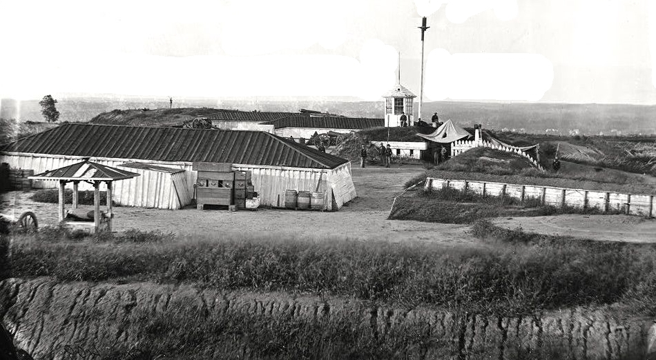 |
| Fort Lincoln Interior |
A Union Civil War earthworks fort was established in 1861 in Northeast Washington D.C. and named after President Abraham Lincoln.
By 1865 the Defenses of Washington DC were said to include some 68 named fortifications, 93 detached batteries, 20 miles of rifle pits, blockhouses at three key points, and 32 miles of military roads. At the beginning of the civil war, there was only a single fort, Fort Washington, protecting the city.
 |
| Fort Lincoln Gun Emplacements 5 & 6. A 100-pounder Parrott Gun is on the right. |
Fort Lincoln was a bastioned fort with four faces that mounted one 100 pounder Parrott and four 20 pounder Parrott guns as well as a number of other major pieces of artillery.
 |
| Battery Jameson earthworks, Fort Lincoln. |
 |
| Fort Lincoln HQ and Officers Quarters. |
A May 17, 1864 report from the Union Inspector of Artillery noted the following:
"Fort Lincoln and Battery Jameson, Captain A.W. Bradbury commanding. Garrison, withdrawn; works guarded by First Maine Battery from Camp Barry, 1 ordnance-sergeant. Armament, eight 6-pounder field guns (bronze), four 12-pounder field guns, five 24-pounder barbettes, one 24-pounder siege, six 32-pounder sea-coast howitzers, two 24-pounder howitzers, two 8-inch howitzers, two Coehorn mortars, one 10-inch mortar, four 30-pounder Parrotts, one 100-pounder Parrott. Two magazines, dry and in good order, one magazine has never had a lock. Ammunition, full supply, and serviceable. Implements, complete, and serviceable."
Fort Lincoln was abandoned in 1865 at the end of the Civil War.
A brief summary of Washington D.C. during the Civil War.
When the Civil War began, newly elected President Abraham Lincoln was only 40 days into his term as President. After the Confederate firing on Fort Sumter and Lincoln’s call for 75,000 volunteers to quell the growing rebellion, Virginia seceded from the Union. Lincoln took great measures to ensure that Maryland, a slave state, did not secede from the Union lest Washington be surrounded by Confederate states. Lincoln imprisoned secessionists in Maryland to prevent Maryland’s secession, and Lincoln’s bold strategy worked.
Throughout the war, Washington saw an exponential increase in population, like its Confederate counterpart, Richmond, Virginia. At the start of the war, 75,080 people lived in Washington, but that number boomed to 200,000 at its peak. By 1862, Lincoln began enacting policies to increase the power of the Federal government in Washington such as military police, prohibition laws, and anti-vagrancy laws. With an expanding population, however, public health often took a back seat to dedicate resources to wounded Union soldiers arriving from the frontlines. The Federal capital saw waves of smallpox run through the city. Generals trained their armies and crafted strategy in and around Washington. Lincoln would often check in on the military to personally oversee the war effort.
 |
| Company E, 4th U.S. Colored Infantry, at Fort Lincoln, Washington DC. Nov. 1865 |
The well-defended city did not experience much combat. When General George B. McClellan took command of the principal Union Army of the Potomac, he built fortifications that stretched 33 miles. By the time McClellan was finished with constructing fortifications, Washington was one of the most fortified cities in the world. The city defenses were nearly impenetrable. Confederate forces did not want to attack Washington directly due to the mountainous defenses. The Confederates made false advances towards Washington to spook Lincoln the high command. One advance was Thomas J. “Stonewall” Jackson’s campaign in the Shenandoah Valley in Spring of 1862, forcing the Union to dedicate forces away from Richmond and towards the Shenandoah Valley. The Union was focused on keeping the war in the South, and the capital in Union hands. Confederates hardly ventured north of the Mason-Dixon Line. Among the few times that the South did venture north, was at Antietam, which was fought before mid-term elections in the Union, and Gettysburg, which was fought one year before Presidential elections. In July of 1864, Lt. Gen. Jubal Early assaulted Fort Stevens, on the north side of Washington. During the battle, Lincoln came under enemy fire and was nearly shot. Jubal Early’s intent with this raid was not to capture and hold Washington, but to divert Union forces from Petersburg to relieve the Confederates from the siege at Petersburg.
While Washington was not much of a military battleground, it was a political battleground. Throughout the war, there was a massive debate about whether to free the enslaved population and perpetually grant enslaved people freedoms. So-called “radical” Republicans and Democrats faced off in the House and Senate chambers debating the soon to be freed people’s rightful freedoms. Lincoln’s original stated war aim was to preserve the Union. Lincoln explained to newspaper editor Horace Greely in August of 1862 that he wanted reunification no matter the cost and wanted to take caution in emancipating slaves in the country. His position on slavery dramatically changed, however, after the Battle of Antietam. Lincoln issued the preliminary Emancipation Proclamation just after the battle which would on January 1, 1863, effectively free all slaves in areas that were in rebellion, but not in the border states of Maryland, Delaware, and Kentucky. Congress passed the 13th Amendment to the Constitution, abolishing slavery in all states present and future in January of 1865, ending the institution of slavery that plagued the United States since its inception.
Towards the end of the war, the city’s water supply ran low due to massive overpopulation. The Army Corps of Engineers constructed an aqueduct to accommodate the city’s need for water. Washington’s police and fire departments were revitalized to provide efficient service to the newly settled residents in Washington. Washington was in the throes of becoming the modern city that L’Enfant and the Founding Fathers had hoped it would become.
At the end of the war, Washington was a sprawling city that became a major city on the eastern coast of the United States. With the 13th, 14th, and 15th Amendments passed and inscribed in the Constitution, formerly enslaved people were now free under the law. Washington became a new hub for many of these formerly enslaved individuals, including Frederick Douglass. On April 14th, 1865, just mere days after the surrender of Robert E. Lee’s forces at Appomattox Court House, Virginia,
Abraham Lincoln was shot in Ford’s Theater by the assassin John Wilkes Booth, a Confederate sympathizer. Lincoln died in the Peterson Boarding House in Washington the next morning. After Lincoln’s death. Andrew Johnson, a southern Democrat, assumed the Presidency. On May 23rd to 25th, 1865, Johnson organized a military precession throughout Washington called the Grand Review of the Armies. This celebration was the precursor to Memorial Day. In 1865, however, the Grand Review of the Armies signaled the end of the Civil War that had ravaged the country.
Compiled by Neil Gale, Ph.D.
[1] In the District of Columbia, the Union Army built the following forts in areas which had remained relatively rural on the limits of the city. Most of the land was privately owned and taken over by the military at the beginning of the Civil War. Most of these owners lost possession of their land for the duration of the war and were unable to receive income from it. Only a few received compensation or rent from the land during the war.

A ring of Union Civil War Forts scattered around the capital city's perimeter was erected early in the war to protect Washington, D.C. from the threat of Confederate assault. This ring included fortifications in Virginia and Maryland as well as Washington DC. By 1865 the Defenses of Washington DC were said to include some 68 named forts, 93 detached batteries, 20 miles of rifle pits, blockhouses at three key points, and 32 miles of military roads. At the beginning of the Civil War, there was only a single fort, Fort Washington, protecting the city.
These numbers are difficult to reconcile because of name changes, consolidations, and upgrading of batteries to named forts. There is also confusion about what fortifications are included especially the permanent fortifications and the outlying fortifications at Baileys Crossroads and Seven Corners. What can be said is that the city was ringed with connected fortifications and that the Virginia side defenses were especially dense with many fortifications within close range of each other. The 37-mile circle of fortifications had platforms for some 1,500 field and siege guns with some 807 guns and 98 mortars in place.
The forts in the District of Columbia were temporary structures. They were in most part built of earthen embankments, timber with limited masonry, and were surrounded by trenches and flanked with abatis. They were not designed to serve beyond the Civil War as the land was intended to be returned to their owner at that time.
 |
| Fort Lincoln and Associated Batteries including Battery Jameson. |
The list below attempts to include all of the named fortifications that surrounded Washington DC during the U.S. Civil War. It does not include camps, barracks, unnamed batteries, and other administrative facilities. I've compiled a list of 93 fortifications and batteries.
Click the Latitude (North/South) and Longitude (East/West) coordinates to see the exact location on digital maps.
Northwest Quadrant
Battery Alexander (MD)
Battery Bailey (MD) 38.95261, -77.11028
Battery Benson (MD)
Battery Cameron (aka Battery Georgetown) 38°54′56.3″N 77°05′19.7″W
Battery Jameson (MD) 38.92796, -76.95219
Battery Kemble 38°55′49.4″N 77°05′46.8″W
Battery Kingsbury 38.96333, -77.04417
Battery Martin Scott 38°55′49.6″N 77°06′40.1″W
Battery Parrott 38°55′14.0″N 77°05′25.8″W
Battery Rossell 38.95457, -77.06956
Battery Sill 38.96111, -77.03833
Battery Smead 38.96139, -77.06056
Battery Terrill 38.95694, -77.06111
Battery Vermont 38°56′15.0″N 77°06′40.0″W
Fort Bayard 38°57′18.7″N 77°05′29.4″W
Fort Cross (MD)
Fort Davis (MD) 38.86639, -76.95056
Fort De Russy 38°57′48.7″N 77°03′04.1″W
Fort Gaines 38.93611, -77.0875
Fort Kearny 38.94833, -77.05833
Fort Kirby (MD)
Fort Mansfield (MD) 38.95297, -77.10164
Fort Reno (aka Fort Pennsylvania) 38°57′10.2″N 77°04′41.9″W
Fort Simmons (MD) 38.95209, -77.09834
Fort Stevens (aka Fort Massachusetts) 38°57′50.2″N 77°01′46″W
Fort Sumner (MD) 38.95669, -77.12247
Northeast Quadrant
Battery Mahan N 38.89500 W 76.94444
Battery Morris 38.92889, -76.97694
Battery Totten 38.95070, -77.00552
Fort Bunker Hill 38°56′08″N 76°59′15″W
Fort Saratoga 38°55′47.3″N 76°58′43.3″W
Fort Scaggs (Not Armed aka Fort Craven & Fort of Circular Form) 38.89112, -76.94855
Fort Slemmer 38°56′23.0″N 77°00′05.0″W
Fort Slocum 38°57′36.7″N 77°00′38.9″W
Fort Thayer 38°55′42.5″N 76°58′16.5″W
Fort Totten 38°56′51.8″N 77°00′18.5″W
Eastern Branch
Battery Carroll 38.83709, -77.00403
Fort Baker 38.86222, -76.96417
Fort Carroll 38°50′16.4″N 77°00′24.7″W
Fort Chaplin 38°53′19″N 76°56′34″W
Fort Davis 38°51′59.6″N 76°57′06.7″W
Fort DuPont 38°52′22.1″N 76°56′26.3″W
Fort Greble 38°49′32.8″N 77°00′55.8″W
Fort Mahan 38°53′42.6″N 76°56′41.6″W
Fort Meigs 38.87351, -76.92941
Fort Ricketts (aka Battery Ricketts) 38°51′24.5″N 76°58′32.8″W
Fort Sedgwick (aka Kennedy's Hill Fort) 38.88417, -76.93639
Fort Snyder 38.84694, -76.9825
Fort Stanton 38°51′29.5″N 76°58′54.9″W
Fort Wagner (aka Fort Good Hope) 38.86, -76.96972
Potomac Approaches
Battery Rogers, VA 38°47′42.6″N 77°2′35.88″W
Fort Foote, MD 38°46′0.1″N 77°01′40.1″W
Fort Washington, MD 38°42′39″N 77°01′59″W
Arlington Line – Virginia
Battery Bayard 38.84919, -77.09195
Battery Garesche 38.83843, -77.09698
Fort Albany 38.86509, -77.06569
Fort Barnard 38.84919, -77.09195
Fort Bennett 38.90025, -77.07863
Fort Berry 38.85559, -77.09161
Fort Buffalo 38.87201, -77.15587
Fort C.F. Smith 38.90083, -77.09056
Fort Cass (later within Fort Myer) 38.88519, -77.08203
Fort Corcoran 38.89626, -77.07592
Fort Craig 38.87041, -77.08165
Fort Ellsworth 38.806, -77.06867
Fort Ethan Allen 38.92444, -77.12361
Fort Farnsworth 38.78861, -77.07361
Fort Haggerty 38.89611, -77.06863
Fort Jackson 38.87129, -77.04141
Fort Lyon 38.79389, -77.07778
Fort Marcy 38°56′2.4″N 77°07′33.6″W
Fort Mc Pherson 38.87273, -77.07381
Fort Morton 38.89192, -77.0871
Fort Munson 38.86026, -77.14507
Fort O'Rourke 38.78704, -77.07319
Fort Ramsay (aka Fort Upton) 38.87284, -77.14623
Fort Reynolds 38.83824, -77.09436
Fort Richardson 38.85773, -77.07783
Fort Runyon 38.86985, -77.04508
Fort Scott 38.8475, -77.05898
Fort Strong (formerly Fort DeKalb) 38.89694, -77.08806
Fort Taylor 38.87476, -77.15898
Fort Tillinghast 38.8785, -77.08383
Fort Ward 38.83026, -77.10264
Fort Weed 38.78929, -77.07832
Fort Whipple (later within Fort Myer) 38.88424, -77.07835
Fort Willard 38.78274, -77.06617
Fort Williams 38.8118, -77.09
Fort Woodbury 38.88966, -77.08281
Fort Worth 38.81472, -77.09889

Fort Lincoln Historical Marker is in Fort Lincoln Cemetery in Colmar Manor, Maryland.
Inscription. These earthworks are a portion of the original fortifications which made up Fort Lincoln. This fort was built during the summer of 1861 to serve as an outer defense of the city of Washington. It was named in honor of President Lincoln by General Order No. 18, A.G.O., Sept. 30, 1861. The brigade of Major General Joseph Hooker was the first to occupy this area. In immediate command of the fort was Captain T.S. Paddock. The Civil War cannons have been placed here through the courtesy of the Department of Defense to commemorate this auspicious occasion.
No comments:
Post a Comment
The Digital Research Library of Illinois History Journal™ is RATED PG-13. Please comment accordingly. Advertisements, spammers and scammers will be removed.