Showing posts with label Ancient Illinois. Show all posts

Saturday, April 13, 2024

The Illinois, aka Illiniwek & Illini: A Chronicle of Power, Demise, and Women's Roles.

The narrative of The Illinois, aka Illiniwek or Illini, unfolds like a saga, etched against the backdrop of the Illinois country. Once a thriving confederacy, they rose to prominence, endured hardship, and ultimately witnessed the decline of their civilization. This interwoven account incorporates various threads, traversing from their early encounters with Europeans to the internal dynamics of Illiniwek society, with a particular focus on women's crucial role.
MEETING OF MARQUETTE AND JOLLIET WITH THE ILLINIWEK TRIBES.


sidebar
The Illinois  is pronounced as plural: [The Illinois'] was a Confederacy of Indian Tribes consisting of the Kaskaskia, Cahokia, Peoria, Tamarais (Tamaroa, Tamarois), Moingwena, Mitchagamie (Michigamea), Chepoussa, Chinkoa, Coiracoentanon, Espeminkia, Maroa, and Tapouara tribes that were of the Algonquin family. They spoke Iroquoian languages. The Illinois called themselves "Ireniouaki" (the French word was Ilinwe). All the tribes seemed to work together without issue. 

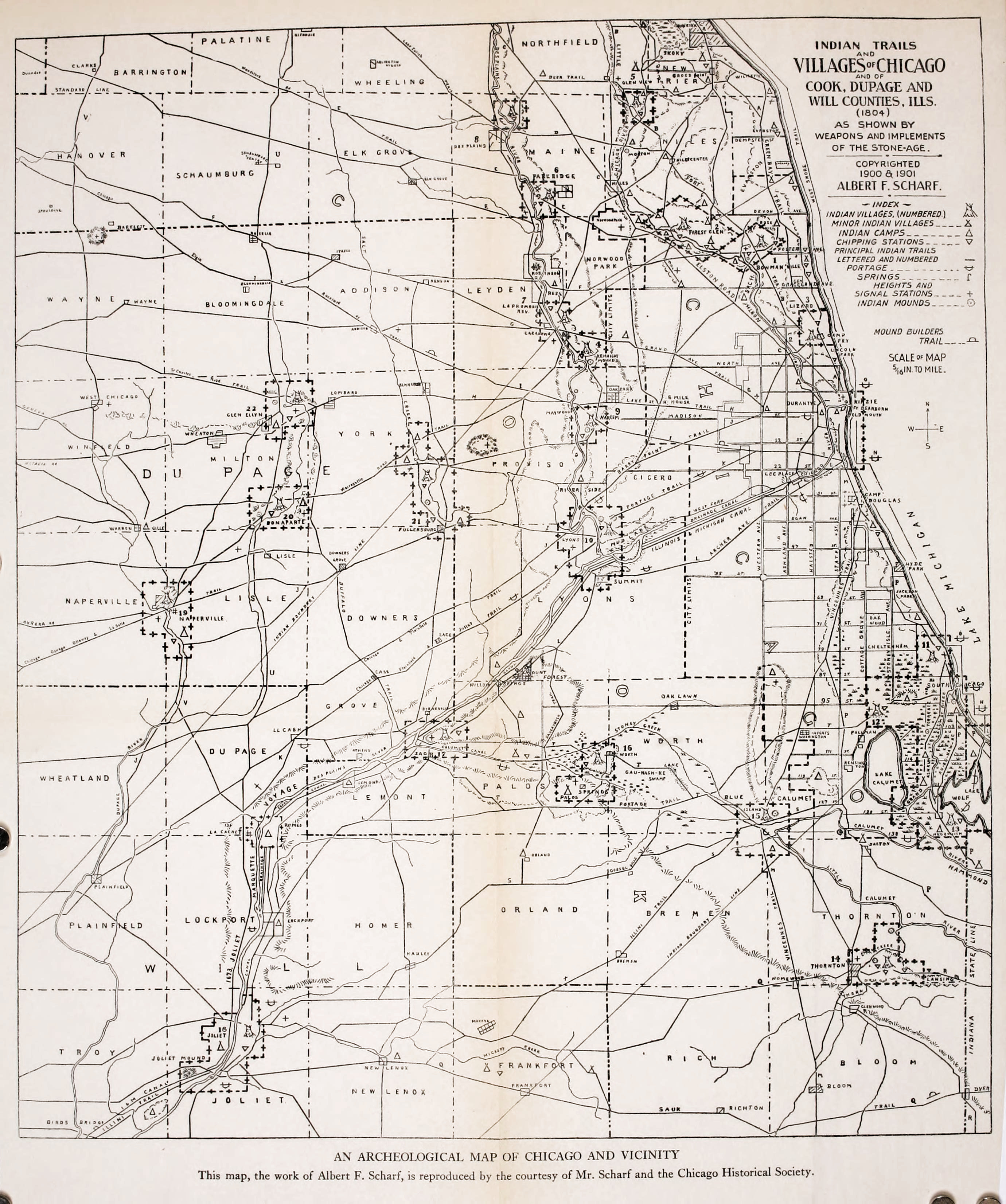
Our story commences with the Grand Village of La Vantum, a bustling metropolis teeming with 6,000 Illiniwek inhabitants. Nestled strategically along the Illinois River, this community thrived. The French explorers Marquette and Jolliet emerged as the first Europeans to set foot in La Vantum in 1673. Chief Chassagoac welcomed the newcomers warmly, exemplifying the Illiniwek's peaceful nature. This initial contact began a complex relationship between the Illiniwek and the Europeans, ultimately reshaping their history.

Before European arrival, the Illiniwek Confederacy, a powerful alliance of Algonquian-speaking tribes, dominated the region. However, the arrival of French missionaries and fur traders in the 17th century ushered in a period of immense change. The Illiniwek, unfortunately, bore the brunt of these transformations. Warfare and the introduction of diseases by the Europeans wreaked havoc on their communities. By the 1830s, a once-mighty confederacy had been reduced to a single village, their ancestral lands ceded to appease European encroachment. The Peoria Tribe of Indians of Oklahoma stands today as the sole remnant of this formidable people.
Illinois Confederation


However, a closer look at the Illiniwek's history in the late 17th century reveals a more nuanced narrative than one of mere decline. Recent scholarship challenges the portrayal of the Illiniwek as a weak and passive people as depicted in early French accounts. Instead, evidence suggests they were a formidable force, strategically leveraging bison hunting and the slave trade to bolster their power. This revisionist perspective underscores the importance of decentering European narratives and foregrounding the agency of Indian groups in shaping their destinies.

A pivotal event that tragically altered the course of Illiniwek history unfolded in the village of La Vantum in 1680. A brutal massacre orchestrated by the Iroquois tribe left an indelible scar on the Illiniwek people. The Iroquois, harboring animosity towards the Illiniwek, descended upon La Vantum, unleashing a torrent of violence. French explorer Tonti, residing in the village alongside a contingent of priests and soldiers, became embroiled in the conflict. The Iroquois, mistaking the French for Illiniwek allies, subjected Tonti to torture. The massacre also claimed the lives of two priests, Fathers Gabriel and Zenobe. Countless Illiniwek people perished in the onslaught, while the survivors were forced to flee, forever displaced from their homeland.

To fully comprehend the Illiniwek Confederacy, we must delve into its foundation – the constituent tribes. The Peoria, Kaskaskia, and Cahokia were just a few prominent groups that united under the banner of the Illiniwek. Interestingly, the name "Illiniwek," signifying "the men," originated from their own designation. Upon encountering this powerful alliance, French explorers bestowed upon them the name Illinois, a moniker that has endured. The arrival of Marquette and Jolliet in 1673, the voyage etched a path down the Mississippi River, marked a significant chapter in the annals of European-Illiniwek interaction.

The narrative is complete by acknowledging women's critical role in Illiniwek society. While Illiniwek women were not traditionally involved in hunting or warfare, their contributions were essential. They shouldered the responsibility of gathering food, nurturing children, and managing the domestic sphere. Their influence extended beyond the household, as some women served as shamans and actively participated in specific ceremonies. Marriages within Illiniwek society adhered to a gift-giving system, and women possessed the remarkable right to divorce their husbands. Although societal norms placed men in a position of higher authority, Illiniwek women wielded considerable power within their designated domain.

The Illiniwek saga, a tapestry woven with threads of triumph and tribulation, stands as a testament to the enduring human spirit. From their initial encounters with Europeans to the internal dynamics of their society, their story offers valuable insights into a bygone era. By delving into the complexities of their history, we gain a deeper appreciation for the Illiniwek people and the indelible mark they left on the landscape of North America.

Compiled by Dr. Neil Gale, Ph.D.

Sunday, March 24, 2024

Marquette and Jolliet French Exploration of the North American Interior, 1673.

On May 17, 1673, Father Jacques Marquette and Louis Jolliet, a skilled cartographer and fur trader, set out on a four-month voyage that carried them thousands of miles through the heart of North America to explore the path of the Mississippi River. The Mississippi's vastness awe-struck them, and they recognized its potential as a major route for trade and exploration.

sidebar
Louis Jolliet likely met Father Marquette at the Jesuit mission at Sault Ste. Marie. Born near Quebec, Joliet had been destined for the priesthood when he decided to change course and become a fur trader.
 
 
Map of Marquette and Jolliet's exploration of the Mississippi River, 1673.


Their voyage helped to initiate the first non-Indian settlement in the North American interior that introduced Christianity into 600,000 square miles of wilderness, gave French names to cities in Wisconsin and Illinois, transformed traditional Indian cultures, and nearly exterminated the fur-bearing mammals of the Upper Midwest.

The two explorers were an unlikely pair. Father Jacques Marquette was a studious Jesuit two weeks shy of his 36th birthday. His partner, Louis Jolliet, was a 27-year-old philosophy and cartography student who had become a fur trader.

sidebar
The word "Mississippi" comes from the Ojibwe Indian Tribe (Algonquian language family) word "Messipi" or "misi-ziibi," which means "Great River" or "Gathering of Waters." French explorers, hearing the Ojibwe word for the river, recorded it in their own language with a similar pronunciation. The Potawatomi (Algonquian language family) pronounced "Mississippi" as the French said it, "Sinnissippi," which was given the meaning "Rocky Waters."

Marquette and Jolliet did not discover the Mississippi. Indians had been using the "Sinnissippi" for thousands of years, and Spanish explorer Hernan De Soto had crossed it more than a century before them. They confirmed that the native peoples who lived along the route were generally friendly and that the natural resources of the lands in between were extraordinary. Equipped with this information, French officials led by the explorer LaSalle would erect a 4,000-mile network of trading posts to systematically exploit those riches over the next century and a half.


They left St. Ignace at the head of Lake Michigan on May 17, 1673. They crossed Wisconsin between June 1 and June 17, then followed the Mississippi River hundreds of miles south to Arkansas.

sidebar
The five voyageurs (names unknown) were almost certainly of French-Canadian or Métis (mixed French and Indian) heritage. They were knowledgeable in wilderness survival, skilled canoeists, guides, and outdoorsmen, making them essential to the success of the expedition.

Two canoes carried seven, including Marquette and Jolliet, paddled by five unnamed voyageurs.


In June of 1673, Father Jacques Marquette, a Jesuit missionary, and Louis Jolliet, a fur trader and skilled cartographer, entered what is now the state of Illinois during their groundbreaking exploration of the Mississippi River. They began their journey in May from St. Ignace in present-day Michigan, intending to find the river's course and potential route to the Pacific Ocean. While their exact duration within Illinois borders is somewhat debated, they spent a significant amount of time exploring the region, likely staying roughly a month before continuing their trip in July.

As they paddled their canoes down the Mississippi, they made an essential encounter with members of The Illinois (aka Illiniwek or Illini) Confederacy. The Illinois comprised several Indian tribes consisting of the Kaskaskia, Cahokia, Peoria, Tamarais (Tamaroa, Tamarois), Moingwena, Mitchagamie (Michigamea), Chepoussa, Chinkoa, Coiracoentanon, Espeminkia, Maroa, and Tapouara tribes that were of the Algonquin family. They spoke Iroquoian languages. The Illinois called themselves "Ireniouaki" (the French word was Ilinwe).

These tribes were welcoming, and the explorers learned much about their culture and way of life. Marquette, fluent in several native languages, likely used his skills to communicate and foster peaceful relationships. The Illinois shared vital information about the river's course and warned of potential dangers downstream, including hostile tribes. 

The relationship between the explorers and the Illinois people were mainly friendly; they engaged in trade and shared information. Marquette, a Jesuit missionary, was keen to learn about their customs and languages while also seeking to introduce them to Christianity.

While in Illinois, Marquette and Jolliet meticulously documented the land they traversed. Marquette likely kept detailed journals of their observations, noting the abundance of wildlife, fertile soil, and diverse plant life they observed. As a cartographer, Jolliet would have carefully mapped out the landscape and river, creating valuable records for future French exploration. Marquette's journal is a valuable historical source offering insight into the geography, flora, fauna, and the lives of the Indians they encountered.

Despite the valuable knowledge and hospitality they received from the Illinois people, Marquette and Jolliet eventually decided to turn back. Rumors of conflicts further south and fears of encountering Spaniards convinced them that continuing the journey was too risky. They reasoned that they had discovered enough to confirm that the Mississippi River emptied into the Gulf of Mexico, not the Pacific Ocean. Thus, they began their return journey in July after a relatively short stay within Illinois' boundaries.

A significant part of their Illinois travels involved venturing up the Illinois River, a major tributary of the Mississippi. This fertile river valley was teeming with wildlife and rich agricultural potential. They likely encountered villages along the river banks,  interacting with more members of the Illinois Confederacy.

On September 30, 1673, they arrived at St. Francis Xavier Mission at modern DePere, Wisconsin.

Marquette and Jolliet's expedition solidified French claims to the territory, paving the way for later colonial expansion into the Mississippi River valley and the establishment of Illinois Country.


Complied by Dr. Neil Gale, Ph.D.

Thursday, January 25, 2024

Scam email about Mammoth and Mastodon Ivory Sales in Illinois.

I'm writing this article, which includes a screen capture of the email below I received as a preemptive warning to Illinois residents and readers from other states.
With the poor spelling and bad English, it is most likely a scam.


Paleo-Indian artifacts are the remnants of tools, weapons, and other objects left behind by the first humans known to inhabit North America, dating from roughly 15,000 to 7,000 years ago. These fascinating objects offer invaluable insights into the lives and technologies of these early peoples despite the challenges of studying such ancient remains.
Mammoths were bigger and heavier compared to their predecessors, the mastodons, and closer in appearance and constitution to elephants today. Mastodons had cusps (grinding bumps) on their molars, which mainly distinguished them from mammoths and elephants with ridged molars.


There's currently no definitive evidence that Paleo-Indians in North America carved mammoth and mastodon ivory as artworks. While some tools and utilitarian objects made from ivory have been found, they lack clear artistic intent or decoration.

Types of artifacts:
Stone tools: These are the most common artifact type, as stone was readily available and durable. Tools include:

Clovis points: Large, lance-shaped spear points with distinctive flutes (grooves) running down the base are iconic symbols of the period.

Other projectile points: Different styles like Folsom, Scottsbluff, and Dalton points reveal regional variations and adaptation to changing environments.

Scraper tools: Used for processing hides, wood, and other materials.

Knives and blades: Employed for cutting and slicing tasks.

Non-stone artifacts: While less common, these offer valuable glimpses into other aspects of life:

Bone tools: Awls, needles, and ornaments made from animal bones suggest various practical and symbolic uses.

Fire hearths and cooking features: Evidence of controlled fire use, crucial for warmth, cooking, and toolmaking.

Rock art and engravings: Rare but potentially offering insights into spiritual beliefs and communication.

Several states have banned the sale of all "Ivory," meaning any tooth or tusk composed of ivory from any animal, including mammoths and mastodons. As of 2024, these states include ILLINOIS, California, New York, New Jersey, New Hampshire, Nevada, Oregon, and Hawaii. Other states may restrict the sale of ivory depending on the item's age, origin, and value.

Since the sale of ivory in Illinois is illegal, reporting it is crucial to protect endangered elephant populations and combat wildlife trafficking. 


Here are some resources to report the sale:
1. Illinois Department of Natural Resources (IDNR):
Online Reporting: You can file a complaint online through the IDNR's Turn in Poachers Website: https://dnr.illinois.gov/lawenforcement/target-poachers.html
Phone: You can call the IDNR's Conservation Police hotline at 1-800-252-8934.

2. U.S. Fish and Wildlife Service (USFWS):
Online Reporting: You can file a report through the USFWS's National Wildlife Service Tip Line: https://www.fws.gov/wildlife-crime-tips
Phone: You can call the USFWS's Division of Law Enforcement at 1-800-847-7353.

3. Wildlife Crime Stoppers:
Online Reporting: You can submit an anonymous tip through Wildlife Crime Stoppers' Website: https://wildlifecrimestoppers.org/contact-us/
Phone: You can call Wildlife Crime Stoppers at 1-800-642-WILD (9453).

Compiled by Dr. Neil Gale, Ph.D.

Thursday, March 30, 2023

ILLINOIS TOWNS NAMED FOR INDIAN CHIEFS

The original inhabitants of the area that had become the State of Illinois in 1818 included the Chickasaw tribe, the Dakota Sioux tribe, the Winnebago (Ho-Chunk, and the Shawnee tribe. 

The indigenous tribes of the Chicago area were the Potawatomi, Ojibwe, and Odawa (Ottawa) Nations, as well as the Miami, Winnebago (Ho-Chunk), Menominee, Sauk (Sac), Meskwaki (Fox), Kickapoo tribes, and the Illinois Confederacy. 

The Illinois, aka Illiniwek and Illini [the Illinois is pronounced as plural: Illinois'], was a Confederacy of Indian tribes consisting of the Kaskaskia, Cahokia, Peoria, Tamarais (aka Tamaroa, Tamarois), Moingwena, Mitchagamie (aka Michigamea), Chepoussa, Chinkoa, Coiracoentanon, Espeminkia, Maroa, and Tapouara tribes that were in the Algonquin Indian family. The Illinois called themselves "Ireniouaki" (the French word was Ilinwe).

MIDWESTERN INDIAN CHIEFS, 1865.


Algonquin, Illinois – Winnebago (Ho-Chunk) - Named after the Algonquin people, a large linguistic group encompassing numerous tribes.

Annawan, Illinois  Derived from the Kickapoo word "Aniwa," meaning "thunder." Named for Chief Annawan.

Aptakisic, Illinois  Potawatomi

Ashkum, Illinois  Named for Chief Ashkum of the Potawatomi tribe.

Aptotakin, Illinois – Named for Chief Optagushick of the Potawatomi tribe.

Big Foot, Illinois  Potawatomi

Cahokia, Illinois – Named after the Cahokia Mounds, a major pre-Columbian Mississippian culture city. While not directly named after a chief, it honors the community's historical leaders.

Chebanse, Illinois  This comes from the Potawatomi word "Zhishibéns," which means "the little duck." Possibly named after Chief Chebanse of the Potawatomi tribe.

Channahon, Illinois  Named for Chief Channahon, a Potawatomi leader. Possibly name for Chief Shabbona.

Chenoa Township, Illinois – From the Ojibwe word "Shenowa," meaning "big." Potentially named after Chief Chenoa of the Peoria tribe.

Du Quoin, Illinois  Kaskaskia

Half Day, Illinois  Potawatomi

Kankakee, Illinois – This comes from the Potawatomi word "Kankakee," which means "cornfield."

Kaskaskia, Illinois – Named after the Kaskaskia tribe, part of the historic Illiniwek confederacy.

Kewanee, Illinois  Named after Chief Kewanee, a Peoria leader.

Lake Ka-ho, Illinois  "Ka-Ho" translates to "big water" in Potawatomi, referencing a nearby lake and possibly honoring tribal leaders associated with the area.

LaSalle Township, Illinois  Named for René-Robert Cavelier, Sieur de La Salle, who had strong ties with Native American tribes.

Loami, Illinois – Possibly from the Miami word "loam," meaning "earth."

Mackinaw, Illinois – Derived from the Ojibwe word "mikinaak," meaning "turtle."

Mahomet, Illinois – Named after the Prophet Muhammad, likely due to a local legend about a Muslim traveler.

Makanda, Illinois  Possibly named after Chief Makandocle of the Kaskaskia tribe, though historical records lack clarity.

Marseilles Township, Illinois  Named for Chief Marseilles, a Potawatomi leader in the 1810s.

Mascoutah, Illinois – Derived from the Mascouten tribe, an Algonquian people.

Matteson, Illinois ─ Named after Chief Matteson, a Potawatomi leader.

Mendota, Illinois – From the Dakota word "Mendota," meaning "junction of two trails."

Menominee, Illinois  Named after the Menominee people, an Algonquian tribe. Historically present in Wisconsin but with cultural ties to Illinois.

Metamora, Illinois – Potawatomi

Mettawa, Illinois – Potawatomi

Minooka, Illinois – Named for Chief Minooka, a Potawatomi leader.

Momence, Illinois ─ Named after Chief Momence, a Potawatomi leader.

Monee Township, Illinois – Possibly named after Chief Monee of the Potawatomi tribe, though this connection lacks definitive proof.

Moosomin Township, Illinois – Possibly derived from the Ojibwe word "moozomin," meaning "moose," but could also be a reference to a chief.

Moweaqua, Illinois – Possibly from the Kickapoo word "Moweaqua," meaning "place of the turtle."

Neponset, Illinois – Possibly named for Chief Neponset, a Massachusett leader.

Niantic, Illinois – Named for the Niantic tribe and their chief, Ninigret. Possibly from the Narragansett word "Niantic," meaning "island."

Niota, Illinois – The name "Niota" was based on the name of a fictional character in a dime novel[1], a Native American chief named "Nee-o-tah." (Algonquian Tribe?)

Oconee, Illinois –  Possibly from the Muscogee word "Oconee," meaning "river."

Okawville, Illinois ─ Potentially named after Chief Okaw of the Kaskaskia tribe. The Kaskaskia word "okahwa" means "big water."

Onarga, Illinois – Comes from the Potawatomi word "Onagan," meaning "white oak."

Oneco, Illinois – Potawatomi

Optakisic, Illinois ─ Named after Chief Optagushick of the Potawatomi tribe.

Oquawka, Illinois – Named for Chief Oquawka, a Sauk leader.

Orland Park, Illinois ─ Potentially derived from Chief Orland, a Potawatomi leader.

Oswego, Illinois ─ Named after Chief Oswego, Possibly a Fox or Sauk leader.

Owaneco, Illinois – Possibly from the Oto word "owanec," meaning "big river."

Pana, Illinois ─ Possibly named after Pana, a chief from the Cahokia tribe. Possibly named after Pana, a Chief from the Cahokia tribe.

Patna, Illinois ─ Kickapoo

Paw Paw Township, Illinois – Believed to be derived from the Miami word "Pawapaw," meaning "fruit of the pawpaw tree." While not referencing a chief, it honors the indigenous culture and environment. Possibly from the Pawnee word "pápa," meaning "head."

Pocahontas, Illinois – Originally known as Hickory Grove and then Amity. In 1850, the name was changed to Pocohontas (with an "o"). 1855, the current spelling with an "a" came into place. Pocahontas was incorporated as a village in 1847. The town was named after Pocahontas Coal.

Pecatonica, Illinois – Derived from the Winnebago word "pekatoniká," meaning "river of the painted feather."

Pekin, Illinois – Named after Chief Pekin, a Peoria leader who signed treaties in the 1810s.

Peoria, Illinois ─ Named after the Peoria tribe and their principal village.

Pesotum, Illinois  The village was named after Pesotum, a Kickapoo warrior in the Battle of Fort Dearborn.

Pontiac, Illinois  Named after Chief Pontiac, an Odawa (Ottawa) leader during the French and Indian War.

Sauk Village, Illinois – Named after the Sauk people, an Algonquian tribe.

Saukenuk, Illinois ─ Named for the Sauk tribes, though not after specific chiefs. (Black Hawk was born in 1767 in Saukenuk, Illinois).

Saunemin, Illinois – Kickapoo

Seneca, Illinois – Named after the Seneca people, one of the Six Nations of the Iroquois Confederacy, it acknowledges their influence and historical connections to the region.

Shabbona Grove, Illinois – Named after Chief Shabbona, a Potawatomi Chief, honoring his role in local history.

Shawneetown, Illinois – Named for the Shawnee people, who lived in the area before being forced to move west. Named after the Shawnee people, an Algonquian tribe.

Shobonier, Illinois – Potawatomi

Tampico, Illinois – Named for Chief Tampico, a Potawatomi or Kaskaskia tribe leader.

Tolono, Illinois – Possibly from the Illiniwek word "Tolowane," meaning "black walnut."

Tonica, Illinois – Possibly from the French word "tonique," meaning "bracing" or "refreshing," influenced by Indigenous names.

Wapella, Illinois – Meskwaki (Fox)

Waukegan, Illinois  Named for Chief Waukegan, a Potawatomi leader.

Wauponsee, Illinois – Potawatomi
Wauponsee is an unincorporated community in Vienna Township, Grundy County, in North East Illinois. Wauponsee is located on Verona Road, 7 miles south-southwest of Morris. Google Mapped: 41°16′28″N 88°29′40″W

The Potawatomi were a major tribe in the Great Lakes region, and they had a significant presence in Wauponsee Township in the early 19th century. The township was named after Potawatomi Chief Waubonsie, whose tribe were residents. Wauponsee Grove, today a state park, was named for Chief Waubonsie.

Wyanet, Illinois – Derived from the Wyandot tribe, an Iroquoian people.

Compiled by Dr. Neil Gale, Ph.D.


[1] DIME NOVEL - Any cheaply produced popular fiction published in the United States between 1860 and 1930 might be called a dime novel, providing it was published on paper covers (paperback) and issued in a series (chapter books).

EXAMPLE
"Malaeska, the Indian Wife of the white hunter" is a groundbreaking novel, considered the first true dime novel. It sparked controversy, having a female author, a sympathetic portrayal of an Indian woman, and a strong, independent heroine. Malaeska tackled themes of race, gender, and frontier life. It was the first published title in Beadle's Dime Novels series and became a runaway bestseller.

The entire series in one (pdf) publication: 
Malaeska is the Indian wife of the white hunter, by Ann S. Stephens. pub:1860.


Friday, September 2, 2022

Sinnissippi Mounds on the Rock River in Sterling, Illinois.

The Sinnissippi Mounds are a Hopewell culture burial mound located in the city of Sterling, Illinois.


The Sinnissippi mounds are a product of the Hopewell culture burial mounds. This tradition flourished in the Sterling, Illinois, area around 2,000 years ago. At that time, the area was at the center of a vast trade network that stretched up and down the Mississippi River. Mounds like the Sinnissippi were common throughout the Mississippi and Ohio River Valleys.

sidebar
The word "Mississippi" comes from the Ojibwe Indian Tribe (Algonquian language family) word "Messipi" or "misi-ziibi," which means "Great River" or "Gathering of Waters." French explorers, hearing the Ojibwe word for the river, recorded it in their own language with a similar pronunciation. The Potawatomi (Algonquian language family) pronounced "Mississippi" as the French said it, "Sinnissippi," which was given the meaning "Rocky Waters."

The first European settler in Sterling, Hezekiah Brink, noted the mounds when he arrived in 1834. Among some of the other early European settlers was a group of men who were interested in starting a Science Club. The Sterling Scientific Club, in existence as early as the 1870s, made one of their goals the investigation of the burial mounds near the Rock River.


W.C. Holbrook investigated the mounds in 1877 and published a lengthy written account in History of Whiteside County, Illinois, published in 1877. One year later, another written account of a mound investigation appeared in The Sterling Daily Gazette. After the 1870s, the burial mounds were looted, and most of the archaeologically significant material was removed.

The Sinnissippi Mounds are part of the Sterling Park District's largest park, Sinnissippi Park. The park was acquired in parcels beginning in 1934. The area of the park where the mounds are found, located on a bluff overlooking the Rock River, was added to the U.S. National Register of Historic Places on May 14, 1979, as the Sinnissippi Site. Despite its public nature, it is listed as one of the National Register's "address restricted" sites.

Compiled by Dr. Neil Gale, Ph.D.

Tuesday, May 10, 2022

A Discovery of an Indian Effigy Mound in the Lake View Community of Chicago, May Date Before 1,000 AD.

Effigy mounds are sacred burial places built by Indians between 800 AD and 1,000 AD. They are extensive earthworks made from soil, usually about 3 to 7 feet high, forming shapes that can be seen from overhead. Some look like bears, and others resemble lizards or turtles.

Map of American Indian trails and villages of Chicago and of Cook, DuPage, and Will counties in 1804 was drawn by Albert F. Scharf 1900, a surveyor and cartographer who took an interest in Chicago’s 19th-century geography.
We'll look for evidence that a lizard-shaped effigy mound existed in Chicago's Lake View neighborhood, who built it, and why it disappeared. The answers to these questions illustrate how racism among early archaeologists prevented them from getting to the bottom of the effigies’ origins.
Scharf’s map shows the text 'LIZARD' (an “Effigy Mound"), located in Chicago's Lake View neighborhood. Effigy mounds are large earthworks made from soil that form shapes that can be seen from overhead.
Archeologists haven’t confirmed the existence of the effigy mound in Lake View, but there is some archival evidence of its location. 

The Scharf map reconstructed a landscape that had been vastly transformed from an area with a few villages and trails to a major city with several outlying suburbs and roads. Scharf relied on accounts from Chicagoans old enough to remember the area before 1833.

His source for the location of the lizard effigy mound was likely an artist and amateur archaeologist named Carl Dilg, who was obsessed with Chicago’s archaeological history and on a personal quest to document the ancient sites of Chicago. As he wrote in a private letter, Dilg wanted to make sure Chicago’s history was not “smothered and killed.”
The Chicago History Museum (formerly the Chicago Historical Society) has an extensive collection of Dilg’s papers, including notes he made from dozens of excursions to archaeological sites around Chicago in the 1880s and 1890s. They contain multiple references to a mound in Lake View, which he referred to as a “lizard” or a “serpent.” Dilg made several sketches of artifacts found near the mound and a map of the area now known as Lake View, showing the exact location of the mound, which you can see on his map.
In Dilg's sketch of the side profile of the lizard mound,
he compares it to another archaeological site in California.
But Dilg didn’t include a precise description of the mound’s length, width, or makeup.

Still, there seems to be significant circumstantial evidence that he’d actually seen it. For one, his depiction of the mound shows the head facing south and the tail facing north, as though the creature was walking south. This is consistent with other water spirit effigies that archaeologists have found in places like Wisconsin. Dilg’s sketches and notes also show the lizard-shaped mound had another round-shaped mound built adjacent to or directly on the “lizard.” This is consistent with the Potawatomi burial practice: The Potawatomi typically constructed conical burial mounds on the site of older effigy mounds. Finally, effigy mounds have been documented as close to Chicago as Aurora, so it’s possible effigy builders’ could have made it to Chicago.

But we know that there’s no lizard mound in Lake View today, so if it did exist, then what happened to it?

About 15 years after Dilg made his sketches, Charles Brown, a distinguished archaeologist from Wisconsin, visited Chicago to review Dilg’s extensive work. Brown wrote about Dilg’s observations, including one sentence about the Lake View effigy mound:

“A ‘lizard mound’ of doubtful origin was located on Oakdale Avenue and Wellington Street, under the present elevated station,” Brown wrote.

Brown’s notes suggest there was some kind of mound that was probably destroyed by the construction of the elevated train line that eventually became the Chicago Transit Authority’s Brown-Line. His use of the phrase “of doubtful origin” suggests Brown, a leading expert on effigy mounds at the time, doubted the mound in Lake View was a true effigy mound like those 800 to 1,200-year-old mounds in Wisconsin.

But archaeologist Amy Rosebrough says Brown has “been known to be wrong.” Brown’s doubt may simply reflect his own disdain at Dilg’s amateur approach to archaeology or his belief that Chicago was not part of the effigy mound builders’ territory, Rosebrough says.

Without a more complete record, Rosebrough and other archaeologists cannot verify if the Lake View mound was an authentic effigy mound or merely a lump of earth that Dilg’s romantic imagination transformed into an ancient sculpture.

If we assume Dilg was correct and the Lake View mound was, in fact, the same kind of effigy mound found in Wisconsin, that raises another critical question that scholars and archaeologists have been asking for 200 years: Who built it?

Early American archaeologists believed the mounds may have been built by a mysterious “lost race” of “mound builders,” sometimes thought to be an earlier Native American civilization connected to Mayan, Aztec, or Incan cultures. Some have theorized the mound builders weren’t indigenous to the Americas, but instead, they were a lost tribe of Israel or a traveling culture, like the Phoenicians or Egyptians.

These hypotheses, which range from unlikely to absurd, reveal a bias common among white Americans in the 19th century: They didn’t believe contemporary groups like the Ho-Chunk, Potawatomi, or Ojibwe, who all lived in areas with effigy mounds, were sophisticated enough to build them.

Richard C Taylor, a writer who traveled through Wisconsin in the 1830s, was typical of the time. He wrote:

“But to a far different race, assuredly, and to a far different period, must we look when seeking to trace the authors of these singular mounds. … But who were they who left almost imperishable memorials on the soil, attesting to the superiority of their race?”

This prejudice made archaeologists slow to accept the idea that these mounds were built by the ancestors of the Indians who lived near the mounds. But eventually, beginning in the early 1900s, American archaeologists began a more deliberate effort to talk with Native Americans about effigy mounds. Charles Brown and Paul Radin, two Wisconsin-based archaeologists, documented extensive conversations with Ho-Chunk people (then known as the Winnebago tribe).

The current consensus among archaeologists is that the mounds were built by several tribes or groups who might have been closely related and treated mound building as a ceremony. Archaeologists believe the Ho-Chunk of Wisconsin is one of several tribal groups descended from people who built effigy mounds, including the Iowa and Winnebago of Nebraska.

Over the years, the Ho-Chunk have claimed to be the descendants of effigy mound builders. In an interview with the Portage Daily Register in 2016, Bill Quackenbush, the cultural resources officer for the Ho-Chunk, said he prefers not to explain the significance of the mounds to outsiders. He said people should try to appreciate the mounds rather than analyze and understand their exact meaning.  
Digging into effigy mounds was a popular pastime during the late 19th century.
“The culture we live in today and society 100 years ago, they tried to do that,” he said. “They dug through them, took screens out there, shook the dirt, and looked for every little piece of information found. They couldn't find what they were trying to get. They had a preconceived notion in their heads already.”

So early settlers destroyed hundreds if not thousands of ancient sculptures, along with the historical record. They plowed under mounds to farm the land or leveled them and built homes on the sites. In some cases, early settlers claimed to have asked local Native Americans about the origins of the mounds without receiving a clear answer.

John Low, a Potawatomi Indian, and professor of American Indian studies, says he’s suspicious of these accounts, given that they took place during a power struggle over land.

“The natives may have said that because they aren’t going to share with people, they regard as the enemy, the specialness they know about a site.” Or, Low suggests, the white settlers may have displayed selective memory.

“We may have been written out of the narrative,” he says. “If the knowledge the natives have about these sites had been transcribed, gosh, that sounds like the natives have more of a claim, and it sounds icky to walk them out to Kansas or Oklahoma.”

By the late 1800s, when Indians were no longer seen as a threat to westward expansion, white Americans became interested in many aspects of their culture, including effigy mounds. But that interest was not necessarily respectful, especially considering mounds often contain human remains, and archaeologists felt free to dig through burial sites and take home human remains for display. Amy Rosebrough describes the popular pastime of “mounding”:

“You take a family out on a picnic and give the kids a shovel and bucket, and they would dig into a mound and see what was there.”

Unless we find new evidence in an archive somewhere (perhaps missing pages from Carl Dilg’s manuscript), Lake View's “lizard effigy” will remain a mystery. That’s because so much of the historical record was lost when the mounds were destroyed, says scholar and Potawatomi Indian John Low. As a Native American, he feels like the destruction of the mounds represents a desecration and willful disrespect of his culture. But he also sees a universal human tragedy.

“It’s something we should all feel sad about when they’re lost,” he says. “Like when the acropolis is lost. Or the pyramids. Or Stonehenge is lost. These, too, are part of the human record of achievement. What a shame.”

ADDITIONAL READING:

Tuesday, March 8, 2022

Illinois' Driftless Region Explained.

The driftless region or zone consists of the extreme northwestern corner of Illinois, southwestern Wisconsin, southeastern Minnesota, and northeastern Iowa. Illinois' driftless region borders are not well defined. Generally, they contain all of Jo Daviess and Stephenson Counties and the western portions of Carroll County near the Mississippi River.
The Upper Mississippi Region, about 15,000 square miles, was miraculously left untouched by glacial erosion and sediments during the last ice age.


Galena, Illinois, is a perfect example of a driftless region. "Driftless" refers to the geological history of the area; its ground hasn't been eroded by glaciers in the Pleistocene (last) Ice Age, nor does it have rocks or sediments (termed drift) transported by the moving glaciers. 


The driftless region is characterized by steep hills, forested ridges, deeply carved river valleys, Karst[1] geology with spring-fed waterfalls, and cold-water trout streams.
The Illinois Counties in the Driftless region.


As in Wisconsin, the Illinois portion of the driftless area became a significant center for Lead and Zinc Mining in the 1800s. The city of Galena was named after the lead sulfide mineral Galena.

In Soldiers Grove, Wisconsin, the Driftless Brewing Company took advantage of the fresh, naturally filtered water. The great-tasting spring water is crucial to brewing their beer brands, and they chose to pay homage to the driftless area they occupy.

Compiled by Dr. Neil Gale, Ph.D.


[1] Karst
is an area of land made up of limestone. 

Limestone, aka chalk or calcium carbonate, is a soft rock that dissolves in water. As rainwater seeps into the rock, it slowly erodes. 
Driftless area in southwest Wisconsin.


Karst landscapes can be worn away from the top or dissolved from a weak point inside the rock. Karst vistas feature caves, underground streams, and sinkholes on the surface. Where erosion has worn away the land above ground, steep rocky cliffs are visible.

                   ██  Karst Landscapes in Illinois.

Tuesday, March 2, 2021

The Prehistoric War Bluff Stone Fort, Pope County, Illinois.

The Stone Forts of Illinois.
One of the unique prehistoric phenomena of Southern Illinois is the ruins of stone walls which have traditionally been known as "stone forts." They appear in the rough east-west alignment across the hill country and appear to form a broken chain between the Ohio and Mississippi Rivers. These ruins have similar geographic site characteristics. They are generally located on bluffs, which are often finger-like promontories of land with steep cliffs on three sides and a gradual incline on the fourth. It was across these inclines leading to the top of the bluff that these stone walls are most generally located, hence the theory of a pound or game trap, has been advanced.

Many of the walls have long been torn down and removed for building purposes. Early settlers, in most instances, removed the better slab-like stones for building foundations, leaving only the rubble. These early white pioneers saw the walls and thought of them in terms of their own experiences, particularly from the standpoint of defense against the Indians. Though they called them stone forts, these sites would be very poor places to carry on prolonged fights.

If a small band took refuge behind the wall, they might be pushed over the cliff by a larger attacking force. Or a larger force could lay siege to the place, and the band would be cut off from both food and water and soon starve to death. Although they called them "forts," many people did not accept such a theory, and speculation continued.

Archaeologists believe that particularly in Ohio, the Hopewellian Indians probably were responsible for some of the walls, but the identity is not known. These walls represent a major accomplishment for a people who had only primitive digging implements and methods of carrying or moving heavy stones. These unknown builders piled rock completely across summits, leaving inside enclosures sometimes as large as 50 acres, depending upon the size of the bluff.
The War Bluff Stone Fort in Southern Illinois lies between the Ohio and Mississippi Rivers.


The War Bluff Stone Fort site is in east-central Pope County, about six and one half miles due north of Golconda and about four and one half miles northwest of the Ohio River. It is about a mile and one-half east of the old village of Raum and about two miles southwest of the old village of Lusk. This fort site lies about one-half mile south of Farm Road 858, across a field, and up the bluff. 

War Bluff is about the most interesting one of its kind. Its wall, though toppled somewhat, is the best-preserved, and its area is large enough to give the visitor's imagination room to dream. There are fragments of records and a stock of legends, lore, and tradition to add interest. 

According to traditional accounts, this was a place to which the Indians retreated and were besieged by white men about 1800. According to the same story, the Indians escaped by way of a secret crevice that led downward through the rocks and out at the face of the bluff. The story relates that a white girl who lived with them led their escape. 

War Bluff also has its "Lovers Leap" on the northwest wall, along with the traditional story. According to this bit of legend, an Indian chief forbade his daughter's marriage to the brave she loved. She and her lover sought to escape but were overtaken at the highest point of the wall. Here their final plea was rejected. Thereupon they turned clasped hands and leaped to their death a hundred feet below. True or untrue, as one stands and looks, it is a good story. 

Then there is an account of buried treasure. According to a story told by an elderly man who grew up near the fort, a band of Indians led by a squaw came to dig for the treasured bars of gold shortly after 1900 and camped at his father's place. The map they carried showed a cave, the mouth of which had been filled. This entrance was found, cleaned out, and followed to a carving indicated on the map. Likewise, they dug through rubble-filled passages to a second marking. Here, squeezed and closed passages brought confusion. The gold bars were not found. 

The Indians despaired and returned to Oklahoma, leaving any treasure still buried at War Bluff. Later visitors with divining rods have likewise failed to locate the gold. Even yet, some visitors knowing the story keep a sharp lookout for any clue that might reveal the location of the hidden bars. 

A shelter cave on the west side also has its story. Once it was carefully walled and served as a home for the Sheridan family. Here their son, Thomas, was born. He later served as a county superintendent of schools and became a practicing attorney in Vienna, Johnson County. 

Before leaving War Bluff the visitor should pause to look carefully at the stone ruins outside the wall. Perhaps he can decide the use to which they were put. Some have said they were granaries, others that they were sentry posts. One explains that they were advance posts for besiegers and lastly that they mark the burial place of white men killed while besieging the Indians. Perhaps the reader will come up with a better explanation than either of these. 

The 1876 atlas shows an additional, old Indian fort on a line five miles northwest of War Bluff and Eight miles Southeast of Stone Fort.
War Bluff Stone Fort
Shawnee National Forest, Illinois

Compiled by Dr. Neil Gale, Ph.D.