
On April 29, 1878, Rogers Park was incorporated as a village in Illinois governed by six trustees. At one time, West Ridge was adjoined with neighboring Rogers Park, but it seceded to become its own village in 1890 over a conflict concerning park districts (known as the Cabbage War) and taxes. Rogers Park and West Ridge were annexed to Chicago on April 4, 1893, each becoming one of Chicago's 77 communities.
THE ENTIRE STORY
Rogers Park originated when the 1816 Treaty of St. Louis was signed by the tribes of the Chippewa, Ottawa, and Potawatomi Indians. The treaty stated that the tribes were to cede a 20-mile-wide and 70-mile-long strip of land to the United States, which connected Chicago and Lake Michigan with the Illinois River. The northern Indian Boundary Line ran west by southwest, from Rogers Avenue from Lake Michigan through what is now Indian Boundary Park in the West Ridge community and eventually to the Des Plaines River.
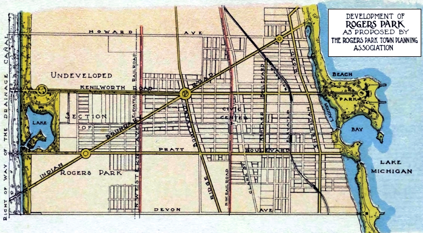 |
| CLICK THE MAP FOR AN ENLARGED VIEW Map of the Rogers Park and West Ridge Chicago communities showing Indian Boundary Road. Interested in the 'LAKE' at Pratt and Kedzie? Click Here. |
During the 1830s and 1840s, German and Luxembourger farmers settled in the area. A small community known as Ridgevill (encompassing parts of Rogers Park and Evanston) grew up around the intersection of Ridge and Church Road. (Church Road was the original name of Devon Avenue before being renamed in the 1880s by Edgewater developer John Lewis Cochran, who named it after 'Devon Station' on the Main Line north of Philadelphia.)
The Great Chicago Fire of 1871 brought a wave of people to the Rogers Park area, looking for new homesteads. In 1872, Rogers' son-in-law, Patrick Touhy, subdivided part of Rogers Park and sold 225 acres of land east of Ridge to a group of businessmen.
The Chicago and North Western (CNW) Railroad's Milwaukee Line came through Rogers Park in 1873, and the Rogers Park Building & Land Company was also organized the same year. The waterworks system, fire department, school, and an active business district were located at Lunt Avenue and Market Street (Today's Ravenswood Avenue) at the CNW Railroad station.
Several hundred people lived in the area, many still farming, but many others were commuting to jobs in Chicago. Rogers Park extended west to the larger of two geological ridges running relatively parallel with Lake Michigan's shoreline. The smaller Ridge is known today as Clark Street, while the larger is Ridge Boulevard.
The village of Rogers Park was incorporated in 1878 by original members of Rogers Park Building & Land Company: John Villiers Farwell, Luther Greenleaf, Stephen Purrington Lunt, Charles H. Morse, and the brothers Paul Pratt and George Pratt, all of whom have a street named after them.
As early as 1886, some farms gave way to buildings and two-story homes; others continued into the 1900s, with fields and greenhouses "neighboring" comfortably with newer brick buildings.
Rogers Park residents increased steadily, reaching about 3,500 in 1890.
West of Rogers Park was unincorporated land. While considered an extension of Rogers Park, "North Town" (not the current Nortown) didn't have an identity and remained relatively rural throughout the 19th century. St. Henry's Roman Catholic Church was the Community's religious and social center. West Ridge (inaccurately called "West Rogers Park" by some today, which is a neighborhood within the West Ridge community), as it's named, was home to Rosehill and St. Henry's cemeteries and the Angel Guardian Orphanage. Truck farms, greenhouses, and the open prairie characterized much of the area.
Disagreements with Rogers Park about taxes for park districts (known as the Cabbage War) led to the incorporation of West Ridge as a village in 1890.
Chicago annexed Rogers Park and West Ridge on April 4, 1893. Unlike in Rogers Park, annexation did not bring rapid growth to West Ridge. The number of residents remained under 500 until after 1900. No prominent business districts existed, as community members relied on either Rogers Park or Evanston for their goods and services.

J.P. Goodwin's Livery Stable was located on Market Street (now Ravenswood Avenue), between Clark Street and Greenleaf Avenue. The fire started in the stable and quickly spread to the surrounding buildings, destroying 14 buildings in one square block. The fire was caused by a spark from a passing train, and it took firefighters several hours to bring it under control. No one was injured in the fire, but several families were homeless.
Besides J.P. Goodwin's Livery Stable, The Town Hall, John Lindley's Store, Phillips Mill, Sharp Bros' Store, Drug Store, Foote's Grocery, and factories and dwellings, fourteen were all burnt to the ground.


In 1896, a bitter fight called the "Cabbage War" ensued, with the West Ridge farmers called "cabbage heads." The West Ridge district won, and the 1897 Ridge Avenue Park District was born. Thus, Indian Boundary Park and Potawatomi Park are in West Ridge.
 |
| The Birch Forest extended from about Birchwood Avenue south to Touhy Avenue, about 1/2 mile, and west to about Ashland in the Rogers Park community of Chicago, 1900 |
At the rate the native white birch trees are dying out on the east side where formerly such fine groves existed, it will not be a great while before all will be gone. —Rogers Park News-Herald, June 29, 1900
 |
| Lincolnwood Coffee Grill and Fountain Shop are located just south of the CTA bus terminal turn-around and Thillens Stadium. It was on the NW corner of Devon and Kedzie, Chicago, and is now just a small grassy field. |
The pace of growth quickened in West Ridge after 1900. Brickyards, formerly located along the North Branch of the Chicago River, moved into the area of present-day Kedzie Avenue to take advantage of the sand and natural clay deposits. The construction of the North Shore Channel of the Sanitary District of Chicago in 1909 increased the amount of clay available. Scandinavian and German workers moved from other parts of Chicago to find jobs in the expanding brickyard operations, and workers' cottages appeared in the western part of the Community. Real Estate interests began to market West Ridge both locally and nationally.
On May 5, 1915, Chicago annexed the area north of Howard Street, east of the "L" tracks, and south of Calvary Cemetery, known as "No Man's Land." The South Evanston area became known as 'Germania' and became home to well-off German and Jewish residents, bringing Rogers Park and Chicago a new northern boundary. No Man's Land was identified by the United States Geological Survey as a variant of the Howard District.
Just after the "L" was extended, between 1910 and 1930, the demand for townhouses and apartment buildings skyrocketed. Rogers Park could stand as its own neighborhood as the "L" made nightlife activities easily accessible, and the construction of theaters gave Rogers Park dwellers constant entertainment. Industry throughout the area meant workers could work close to home, and Catholic and Protestant churches and the Jewish synagogues accentuated the neighborhood with religious diversity.
The end of World War I triggered a real-estate boom in West Ridge. Brick bungalows and two flats became the dominant residential structures in the neighborhood. Apartment buildings also appeared, but relatively poor transportation facilities in the area before 1930 limited the demand for large multiunit buildings. By the end of the 1920s, Park Gables and several Tudor revival apartment buildings clustered around Indian Boundary Park. A tennis club built in the Tudor revival style opened at 1925 West Thome Avenue. A business district along Devon Avenue also developed during this period. The area's population swelled from about 7,500 in 1920 to almost 40,000 by 1930, and local residents looked to their Community for goods and services.
Unlike many Chicago communities, West Ridge grew steadily during the 1930s. However, population growth and economic development did not alter the Community's overwhelming residential character. The area has no manufacturing establishments, and its economic base remains primarily commercial. Population growth necessitated more housing units, and larger, multiunit structures appeared. One of the most significant residential construction projects in Chicago during the 1930s, the Granville Garden Apartments in the 6200 block of Hoyne Avenue, was built in 1938 to help meet the need for housing.
West Ridge continued to draw families. In 1949, Hollywood Kiddieland opened on McCormick Boulevard and Devon Avenue. The mid-1950s saw Bounceland, a trampoline park, open on Devon Avenue just east of Lincoln Avenue. Beginning in the 1950s through the late 1970s, there were 15 Bakeries on Devon Avenue (◄─ names and addresses) between Kedzie and Ridge Avenues, within two miles in distance, in West Ridge.
Lots of restaurants sprouted up, then changed owners. Some changed names but continued to draw people from Chicago's northside and the north and northwestern suburbs. Some of the Community's favorites were Hot Dog Joints like The Red Hot Ranch, Ruby's Hot Dogs (Rockwell and Devon at the alley), Fluky's, Wolfy's, Gilly's Hot Dogs (California & Devon at the alley), DanDees, Paul's Umbrella (Touhy & California NE corner), Terry's Hot Dogs (Touhy & E of California) and Dewey's Hamburger & Chili to mention just a few.
 |
| The Red Hot Ranch, 3118 West Devon Avenue, Chicago, Illinois. (1952-1985) |
Rogers Park and West Ridge were also home to several Movie Theaters and Bowling Alleys that entertained kids and adults alike.
A small part of West Ridge's West Rogers Park neighborhood was known as the "Golden Ghetto." The boundaries were Pratt Boulevard to the north, Western Avenue to the east, Peterson Avenue to the south, and Kedzie Avenue to the west. The name came from the thriving Jewish Community from about 1930 to the mid-1970s when the Jewish migration to the northern and northwestern suburbs in the mid-1960s became noticeable.
sidebar
The City of Chicago, Cook County, and the State of Illinois Never officially referred to Rogers Park and West Ridge communities or their neighborhoods by "Parish" names.
Compiled by Dr. Neil Gale, Ph.D.
ADDITIONAL READING:
The 1960s & 70s Devon Avenue Bakeries in Chicago.
The Oldest House in Chicago's West Ridge Community.
The "Birdcage Apartments" at 6901 North Ridge Boulevard (at Farwell) in Chicago was built by architect Don Erickson in 1959.
A primer on the difference between a Chicago community and a Chicago neighborhood.
The History of the Edgewater Golf Club (Today's Warren Park) in Chicago, Illinois.
The History of Chicago / Evanston Telephone Exchanges Including their Two-Letter Codes and Meanings.
"The Spirit of the Fighting Yank," WWII Memorial in Chicago, Illinois.
Frankenstein's Bar, 2235 West Howard Street, Chicago, Illinois.
Since my Italian family came West to live Northwest when my Irish and Swiss family lived in the center of town to migrate and farm in Wisconsin...Great Grandpa came to live North Chicago, but worked as a Streetcar conductor, while my Italian Grandfather developed a wonderful restaurant by the Harding theater....I am most interested in the families that began west or northwest to migrate North! Thank you for this wonderful article!
ReplyDeleteMy parents and maternal grandmother lived in the Granville Garden Apartment complex in the 40's and 50's. So exciting to see this mentioned. Very informative article, thanks for researching this!
ReplyDeleteThere is a book entitled " Chicago's Far North Side " published by the Rogers Park/ West Ridge Historical Society which is a must-read about this area.
ReplyDeleteThank you, I love these articles about the far north side. Our first home was on Greenleaf, just west of California, which I am relieved to know is, in fact West Rogers Park. (I much prefer that name to West Ridge.) I would also like to say that if you are a baby boomer or greatest generation, and Roman Catholic, you most definitely referred to your neighborhood by the name of the parish.
ReplyDeleteWest Ridge is the Community name and West Rogers Park is a neighborhood in West Ridge.
DeleteAbsolutely!!!!
DeleteI wonder if anyone knows the history of Western and Pratt. I know about the bowling alley and Bingo parlor prior to the current senior housing/library but what cam before then? Was there ever any residences along Western near this intersection? Thank you!
ReplyDeleteWhere can I find info or photos about this intriguing "Beach Park" along the shore of what is today Touhy? I wonder why they would remove a nice existing park?
ReplyDeleteWhose livery stable was it that burned in 1894?
ReplyDeleteJ.P. Goodwin's Livery Stable was located on Market Street (now Ravenswood Avenue), between Clark Street and Greenleaf Avenue. The fire started in the stable and quickly spread to the surrounding buildings, destroying a total of 14 buildings in one square block. The fire was caused by a spark from a passing train, and it took firefighters several hours to bring it under control. No one was injured in the fire, but several families were left homeless.
Delete