
Chicago's early history, consecutive movements of population, the encroachment of commerce and industry as the settlement crossed the north branch of the river and sprawled northward, have all left their impressions.
Indians camped along the river where great factories smoked and thousands of vehicles clamor at the bridges. Indeed, it is just over two hundred and forty years ago, as tradition has it, since a black man from San Marc, Haiti, bearing the ornate name of Jean Baptiste Point de Sable (the "du" of Point du Sable is a misnomer. It is an American corruption of "de" as pronounced in French. "Jean Baptiste Point du Sable" first appears long after his death), built the first log cabin in 1779 of what was to be the settlement called Chécagou, on the north bank of the river.
Antoine Ouilmette was the first permanent white settler of Chicago building a cabin at the mouth of the Chicago River near du Sable's cabin in July of 1790 (see illustration below).
Du Sable's cabin was later acquired by John Kinzie in 1804. Kinzie's cabin became the center of a little settlement near the stockade of the long-vanished Fort Dearborn.
 |
| The Kinzie Mansion. The House in the background is that of Antoine Ouilmette. Illustration from 1827. Successive owners and occupants include:
|

In 1845 there were only about 5,000 white people between Chicago and the Pacific Ocean.
 |
| The United States and Territories in 1840-1842 |
Note: There was no California in 1840. The 1st California Census was in 1850 and reported 92,597 citizens after the California Gold Rush in 1848. The 1890 Census was the first one to count Indigenous people throughout the country.On the northwest corner of Michigan Boulevard and Lake Street was a very large, vacant field, which was usually filled with camping parties, and whole communities migrating from the East to the West. It was common to see a long line of prairie schooners drive into this field, with cows tied behind the covered wagons. There they would unload for the night. There was always mystery and charm about their evening campfires.
The greatest excitement was the arrival of the weekly boat from Buffalo, New York. These boats brought many supplies and our only news from the outside world. In those days the great West Side, as we know it now, did not exist; and even the North Side seemed like a separate town because there were only one or two bridges connecting the two sides of town.
THE EIGHTEEN SIXTIES
In the decade and a half before the Civil War, the city grew rapidly, and by 1860 there were 29,922 people living north of the river. During the years between 1850 and 1860, nearly half of Chicago's increase in population was by foreign immigration, as it was also between 1860 and 1870.
And while previous to 1860, the population of the North Side was mainly Indians, the first statistics available on the composition of Chicago's population by wards, those for 1866, show that there were then a considerable number of Irish and Germans living in the North Division. The Irish, the first of five waves of immigration that were to sweep over the Near North Side, began coming soon after the Irish.
The commercial importance of the North Branch continued to grow. The tanning and meat-packing industries were located along the river. The lumber business was rapidly increasing; warehouses were rapidly being built. In 1857 Chicago's first iron and steel industry began on the banks of the Chicago River with the opening of the North Chicago Rolling Mills Company, about two and a half miles northwest of the city's center.
Later, as railroads came into the city, a number of machine shops were built on Clark, Wells, State, Erie, Kinzie, and Division streets and on Chicago and North avenues, thus binding the North Side more closely to the activities of the city as a whole.
Starting in 1858, horse-drawn streetcars began to run lines on Clark, Wells, and Larrabee streets and across Chicago Avenue and Division Street, run by the Chicago City Railway Company and the North Chicago City Railway Company.
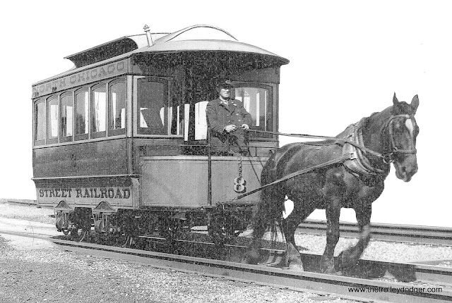 |
| Although the Chicago Surface Lines built some replica vehicles in the 1930s, North Chicago City Railway Company's Street Railroad car № 8 is not among them. The original, built in 1859, we see it here in demonstration service during the 1948 and 1949 Chicago Railroad Fair (link includes both years' Official Guide Books in PDF) on the lakefront. This car № 8 is preserved at the Illinois Railway Museum. |
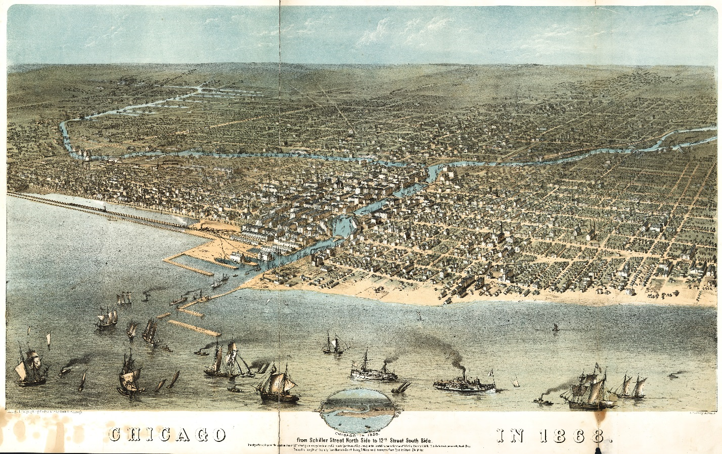 |
| From Schiller Street North to 12th Street (Roosevelt Road) South Side. 1868 CLICK FOR A FULL-SIZE MAP. |
The Near North Side has always been, more or less, the fashionable residence district. In the 1860s, the fashionable and aristocratic residence section of Chicago on the North Side was in the district from Chicago Avenue south to Michigan Street (Hubbard Street), and from Clark Street east to Cass Street (Wabash Avenue). Residences on Ohio, Ontario, Erie, Superior, Rush, Cass, Pine (Michigan Avenue), Dearborn, and North State streets appear frequently in the "society columns" and Chicago directories of the 1860s. On these streets, the leading families of the early settlers and the early aristocracy lived, with South Michigan Boulevard the fashionable street of the day. It was not until the 1890s that Lake Shore Drive became 'the' place to live.
One of these early aristocracy writes:
The North Side was "home," and a lovely, homelike place it was. The large grounds and beautiful shade-trees about so many residences gave a sense of space, rest, flowers, sunshine and shadows, that hardly belongs nowadays to the idea of a city. There was great friendliness, and much simple, charming living.Between Clark and Wells Streets, south of Chicago Avenue, was a neighborhood of storekeepers and merchants, while west of Wells lived the laboring people. In this area, there were a number of laborers' boarding houses and cheap saloons. At this time, there was nothing but a sandy waste between Cass Street (Wabash Avenue) and the lakefront.
Over between Clark, Illinois, Dearborn, and Indiana streets stood the old North Side Market, where the men of the families often took their market-baskets in the morning, while the "virtuous woman" stayed at home "and looked well to the ways of her household."
Another institution of our day was the custom of sitting on the front steps though even then there were those who rather scorned that democratic meeting place. But for those of us who did not rejoice in porches and large grounds, they had their joys…. In fact, it was even possible for unconventional people like ourselves to carry out chairs and sit on the board platforms built across the ditches that ran along each side of the street, and on which carriages drove up to the sidewalks.
Of course there were "high teas," when our mothers and fathers were regaled with "pound to a pound" preserves, chicken salad, escalloped oysters, pound-cake, fruit-cake, and all other cakes known to womankind; and where they played old-fashioned whist and chess.
...Parties usually began about half-past seven or eight o'clock, and "the ball broke" generally about eleven or twelve o'clock; where there was no dancing it ended at ten or eleven o'clock.
Of course there was no "organized charity," as we know it nowadays, but there was much of that now despised "basket charity," when friendships were formed between rich and poor.
And there was an unsavory population on the sand flats at the mouth of the river and immediately along its banks, known as “Shanty Town,” and ruled over by the “Queen of the Sands,” Emma "Ma" Streeter. A memorable event of the decade was the raid on the “Sands” led by “Long John” Wentworth, then-mayor, when the police razed the Sands brothels amid the mingled cheers and hisses of the populace.
The Irish had settled along the river, to the south and west. The settlement extended as far east as State Street immediately along the river, but most of the Irish lived between Kinzie and Erie, in the vicinity of old Market Street.
In 1853, William B. Ogden, a Chicago real estate developer, built a channel to provide a more straightforward alternative to the Chicago River’s winding North Branch. The result was an island, the only island in Chicago. This river settlement along the North Branch was known as "Kilgubbin," or more often, as "the Patch". It quickly became a haven for Irish immigrants who were so poor they couldn’t afford proper housing. The island was dubbed Kilgubbin, after the area most of them were originally from. Taking a cue from the life they left behind in Europe, they built flimsy wooden homes with gardens and farms where they raised cabbage and vegetables and livestock. As the city grew around them, the island got a few factories, but other than that, it barely changed. Chicagoans came to see the residents as backward, treating them with a mixture of pity and mockery, so they called Kilgubbin “Goose Island.”
The Irish were then mostly laborers, not having been in America long enough to have exploited their flair for politics. However, they were already displaying their love of a fight, and a solidly Irish regiment was recruited from Kilgubbin during the Civil War. Kilgubbin was a squatters’ village and contained within it a lawless element. In an article printed in the Chicago Times in August of 1865, some account is given of Kilgubbin and its population:
At the head of the list of the squatter villages of Chicago stands "Kilgubbin," the largest settlement within its limits. It has a varied history, having been the terror of constables, sheriffs, and policemen. It numbered several years ago many thousand inhabitants of all ages and habits, besides large droves of geese, goslings, pigs, and rats. It was a safe retreat for criminals, policemen not venturing to invade its precincts, or even cross the border, without having a strong reserve force.The Germans, on the other hand, were gardeners rather than laborers. Very few went into business, though there were three breweries owned by Germans where the Chicago Water Tower's pumping station now stands. But the majority of the Germans lived north of Chicago Avenue and east of Clark Street, in cottages on small farms or gardens, and did truck farming. There were German families scattered along Clark, La Salle, and Wells streets. And the German element, for a time, found the center of its social activities in the vicinity of the German Theater, at the corner of Wells and Indiana Streets (Franklin Boulevard). This theater was supported by a German musical society, offered "the first purely musical entertainment ever presented in Chicago," and continued to present dramatic sketches in the German language for years.
The city limits extended at this time, 1860-70, to North Avenue. But until after the Great Chicago Fire in 1871, the area north of Division Street, and even north of Chicago Avenue to the west, was practically still the "country."
Compiled by Dr. Neil Gale, Ph.D.
No comments:
Post a Comment
The Digital Research Library of Illinois History Journal™ is RATED PG-13. Please comment accordingly. Advertisements, spammers and scammers will be removed.