Tuesday, January 28, 2020

The History of Clark Street in the Rogers Park Community of Chicago, Illinois.

Long before Illinois statehood, the glacial ridge that is now Clark Street was only seasonably navigable north of today's Peterson Avenue. The original inhabitants of this area that is now Rogers Park and West Ridge included: the Chickasaw tribe, the Dakota Sioux tribe, the Ho-Chunk tribe (Winnebago), the Miami tribe, the Shawnee tribe, and the Illinois tribe (Illiniwek).
The Illiniwek [aka Illini, and the Illinois (pronounced as plural: Illinois')], were a Confederacy of Indian tribes consisted of the Kaskaskia, Cahokia, Peoria, Tamaroa, Moingwena, Michigamea, Chepoussa, Chinkoa, Coiracoentanon, Espeminkia, Maroa, and Tapouara tribes that were all part of the Algonquin family.
The tribes used the higher glacial ridge, now Ridge Boulevard, for travel to and from their villages south of Chicago to hunting grounds in upper Minnesota and Wisconsin, called the Green Bay Trail, aka "Old Jambeau Trail,"  way before it was named Chicago Avenue.

The Treaty of St. Louis signed in 1816 between the United States and area tribes (Potawatomi, Ottawa, the Chippewa) involved the United States obtaining a 20-mile strip of land known as “The Indian Boundary” connecting Lake Michigan to the Illinois River.

Indian Boundary Park in Chicago's West Ridge Community is named after this event. The 1833 Treaty of Chicago following the 1832 Black Hawk War, evicted the Indian tribes from the area.
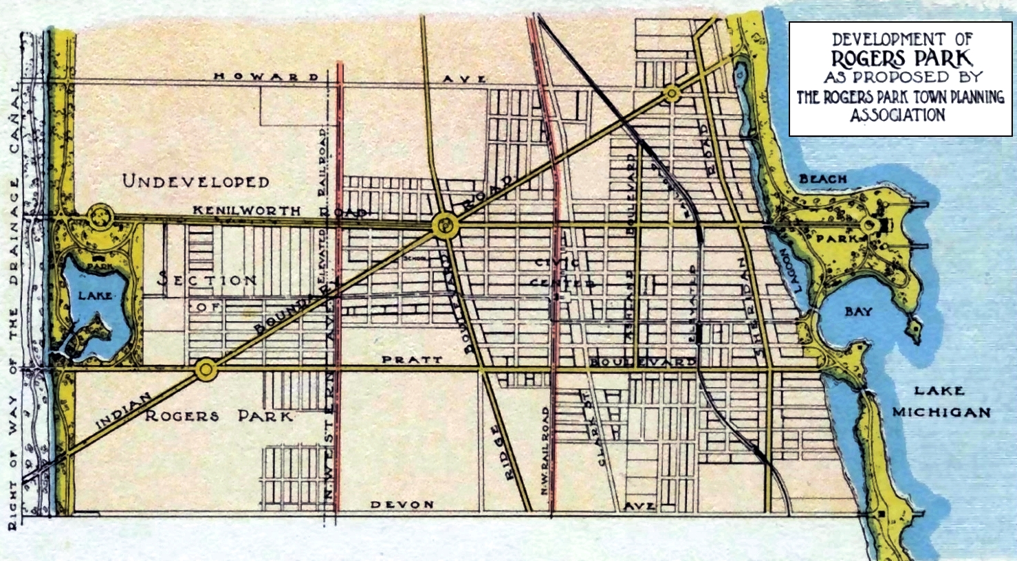
CLICK MAP FOR ENLARGED VIEW
Map of the Rogers Park and West Ridge communities of Chicago showing Indian Boundary Road. - Interested in the 'LAKE' at Pratt and Kedzie?
Phillip Rogers began buying land from the government in the 1830s, and by the time of his death in 1856, Rogers owned 1,600 acres of government land, part of which formed the basis of Rogers Park. In the beginning, Clark Street, known then as Chicago Avenue, was a mere path connecting the growing settlement of Chicago to the cluster of Ridgevill farms and homes. The growth of the railroad and canals contributed to the development of Chicago and the surrounding communities.

In the mid-1850s, landowners sold right of way to the Chicago and Milwaukee Railroad, and shortly thereafter a commercial rail line was built, roughly paralleling what is now Clark Street. For its first 15 years of operation, there were no stations on this line in Rogers Park; but there are oral histories that state farmers on the Ridge had worked out a signal with the train engineers to create an informal stop for pickup and delivery of fresh produce and supplies to the Water Street Market (now Wacker Drive). Temperance would also define Rogers Park, as the 1853 charter for Northwestern University established a four-mile alcohol-free zone within the radius of the school. 
In 1869 a tollgate was installed at Rogers and Clark to profit from people traveling to Calvary Cemetery. 1884 Illustration. rpwrhs
With the railroad firmly in Rogers Park, around 1873 the Chicago and Milwaukee Railroad opened its Rogers Park station. An economic center emerged between Lunt and Greenleaf, extending to Clark Street, centered around the new stop on the Chicago and Northwest Rail Line near the location of the modern Metra station. By 1910 the tracks were elevated and a new station was built.

The early structures were wood frame with wooden sidewalks elevated above unpaved and often muddy streets. These were mostly two-story buildings with the storefronts on the bottom, with tenants or the store owners living above. The early businesses on Clark were catering to the new homeowners that were mainly white-collar workers commuting to downtown Chicago offices or railway workers.
Clark and Greenleaf, 1875. rpwrhs
The Great Chicago Fire of 1871 created a housing boom in Rogers Park, leading to denser settlement as well as an increase in economic activity. With a broader tax base and settlement, the Village of Rogers Park was formed in 1878. During this time the western portion of Rogers Park was still dominated by farmland while the eastern side was still undeveloped marsh.

In 1881, a three-story “brick building was erected on the southeast corner of Clark Street and Estes Avenue to serve as the Village Hall.” It also functioned as the police department, jail, and fire department. The first Rogers Park library was on Clark Street.

The oldest dairy that served Rogers Park existed between Rogers and Birchwood, east of Clark, founded by John Francis Ure in 1887 on his grandfather's, John Calder Ure's property. Ure obtained his milk supply from nearby Wilmette and eventually sold his business to the Bowman Dairy Company of Chicago in the early 1920s. 

John donated the right-of-way for Howard Avenue. Howard J. Ure was actually born John James Ure on January 13, 1896, at 5138 N. Clark Street (today, 7527 N. Clark Street). Howard, a banker, became a director of the Howard Avenue Trust and Savings Bank at the early age of 26. The Ure family had a heavy hand in developing the Howard Street district, which is named after Howard Ure (1896-1984) as is the Howard (Ure) Beach, Park.
The John Ure Dairy, 1914. rpwrhs
In 1888, the Weimeschkirch family opened a funeral home at 4861 N. Clark Street, (today, 7066-68 N. Clark Street). At some point, they Americanized their last name to Weimeskirch. They would be open for about 100 years serving the community with caskets and embalming, as well as a funeral hearse and ambulance needs. 
P. Weimeschkirch Undertaker at 4861 N. Clark Street, (today, 7066-68 N. Clark Street). rpwrhs
In 1891, Clark Street was finally paved between Devon and Chase. The 1893 World Columbia Exposition excited Rogers Park residents and some reported “growing support in favor of annexation,” thinking it would improve economic prospects. 
From the Evanston, Rogers Park and Wilmette Directory, 1892.
Weimeschirch funeral home closed in 1988. rpwrhs
In 1893 Rogers Park and the neighboring community of West Ridge were officially annexed to Chicago. The annexation improved infrastructure: streets were paved, gas and electric service were provided, and better sewers were installed, allowing the area east of the original Rogers Park subdivision to be drained and subdivided into parcels for development. Fire and Police services also improved.

A year after annexation into Chicago, Rogers Park had a major fire on August 8, 1894. At 9:30am an entire block of Rogers Park was wiped-out by fire. The Town Hall, Livery Stable, John Lindley's Store, Phillips Mill, Sharp Bros' Store, Drug Store, and Foote's Grocery, along with factories and dwellings, fourteen in all, while ten families were driven out homeless. 
As a product of the fire, stricter building codes were enforced and brick construction was mandated. The fire also illustrated a need to have a dependable water supply and better water infrastructure.  The rest of the decade was marked by a national economic depression; called "The Panic of 1893." In 1896, street light posts and fire hydrants were installed.

A 1901 business directory reflected “the addition of service providers to make goods needed by the new families, as well as support for the growing new housing market."

Residential housing begins to shift during this time from single-family to multi-unit dwellings as “the neighborhood’s suburban qualities faded.” Today you can still spot evidence of these important neighborhood buildings along Clark Street; they are still evolving to suit the community needs.
The Doland Block Building was built in 1900 at 7000 N. Clark Street. It was used as a Masonic Hall and was the original location of the Rogers Park Women’s Club. It became the first Rogers Park Library in 1905 when the Chicago Public Library took over and created a circulating library and deposit station.
By 1900 the population and commercial district were centered around the train station at Greenleaf and Clark.  By 1910 the railroad was elevated.
Railroad Station Greenleaf and Lunt, 1910. rpwrhs
Part of the population boom discussed during this period also had to do with the Northwestern Elevated Railroad (now-CTA Red Line) opening up a Howard Street Station in 1908. Development allowed for more people to easily commute downtown and helped make the far North Side a desirable place to live. The commercial areas near the station stops remain vital to the business community today as well.

Between the 1870s and 1930s local commercial district buildings were between two and three floors. Retail businesses would occupy commercial space on the ground floor while offices or apartments would be above. It was noted that “these buildings should be tightly spaced to maximize square footage. Quality materials and ornamentation were reserved for street elevations. The storefronts themselves were basically large panes of fixed glass supported by wood or metal mullions with a center-of-side entrance.

By 1920, the neighborhood had a population of 27,000 and was upper-middle class. Historians credit the 1920s period in Rogers Park for creating a building boom not matched for the next 80 years. The entertainment district developed on Howard Street around this time which became a hub of nightlife for the entire North Shore. Meanwhile, shops on Clark Street catered to residents, while also complementing the high-end entertainment and social needs of the area. Clark Street continued to be the main shopping district of Rogers Park. Moreover, it contained important institutions such as the police station, post office, and library. 

The Clark Devon Hardware at 6401 North Clark Street opened in 1924, the first of five Clark Street locations, by founder, William Walchak. The building had been at various times, a theater, a dance hall, an indoor soccer stadium, and a film production studio before it became a hardware store. The store moved from the corner to Clark and Wallen. From there it moved to 6339 North Clark Street. Then came the move to Clark and Highland, 6333 North Clark. In 1984, third-generation owners, Ken and Ed Walchak orchestrated the store’s move, back to the corner where it started and the store’s name once again matched its location and remains a local iconic store.
A 2-ton, lighted, stainless steel clock, added in 2012, on the building's southwest corner has already become a neighborhood icon.
The Rogers Park Chicago Library branch location was opened in 1917 at 6957 North Clark Street and lasted until 1922 when a more suitable location was built at 1731 West Greenleaf. The Greenleaf location would eventually be destroyed in a fire in 1951.
The Rogers Park Library at 6957 N. Clark Street. A Prudential Insurance office is on the second floor. rpwrhs
The number of people using public transportation through Clark Street remained a stabilizing force for local businesses. In 1910 the Chicago and North Western rail bed was elevated and a new station was built above street level.  This embankment cut off the retail activity on Market Street and divided Ravenswood into a light industrial area on the East and residential on the West. Another change to local transportation occurred in 1913 when the electric streetcars that ran along Clark were consolidated into the Chicago Surface Lanes.

The Devon Avenue car barn located at 6454-64 North Clark, was built in 1901 and housed the streetcars that cruised through Rogers Park. These streetcars housed the Clark #22, Broadway #36, and Western #49B lines. In 1922, a major fire devastated the building destroying a large part of the fleet. The facility was closed in 1957, and the site is now occupied by the 24th District Police Department. The Clark #22 bus is still an active line that connects Rogers Park to downtown Chicago.
Bus Barn, 6454-64 N. Clark Street, 1930. rpwrhs
As Rogers Park was growing into a wealthy community, residents had disposable income to spend on entertainment. While Howard Street was the official entertainment district, Clark Street had two movie houses. These were the Casino Theater 7053 North Clark, and the Adelphi Theater, 7074 North Clark at Estes. The Casino Theater (1915-1918), was the oldest motion picture theater in Rogers Park. Local historian Larry Shure mentions “for a small admission you could enter and stay as long as you like. A typical nickelodeon might show short features 16 hours a day, from 8 a.m. until midnight."

By 1918 the nickelodeon-type “Photo Play” was going out of style as real “Movie Palaces” started to appear. The death of the Casino Theater was the beginning of the construction of the luxurious  Adelphi Theater which was built at Estes and Clark in 1917, 14 years after the deadly Iroquois Theater fireThe original owners of the Adelphi theater were the Ascher Brothers who operated the theater between 1917-1927. A bowling alley would occupy the second floor from 1922-1927. The Adelphi would be torn down in 2006.
Adelphi Theater, 1917. rpwrhs
Adelphi Theater Interior, 1917. rpwrhs
Resident Edward Mogul reflected on the Adelphi Theater in the 1940s and 50s:
“I went to the Adelphi with my neighbors on a regular basis, usually arriving early on Saturday  morning. We would spend hours there watching thirty cartoons in a row and then Flash Gordon and Superman and we would come out of the theater with our eyes crossed.”
Chicago theaters designed by J. E. O. Pridmore (1867-1940):
  • National Theater (1904)
  • College Theater (1907)
  • Oak Theater (1910)
  • Columbia Theater (1911)
  • The Victoria Theater (1912)
  • Lexington Theatre (1912)
  • Empress Theater (1913)
  • Adelphi Theater (1917)
  • Sheridan Theatre (1927)
  • Nortown Theater (1931)
  • Evanston Theater (1937)
ADDITIONAL READING: Chicago's Rogers Park and West Ridge Communities Movie Theaters History.

Resident Edward Mogul reflected on the Adelphi Theater in the 1940s and 50s:
“I went to the Adelphi with my neighbors on a regular basis, usually arriving early on Saturday  morning. We would spend hours there watching thirty cartoons in a row and then Flash Gordon and Superman and we would come out of the theater with our eyes crossed.”
After the Second World War, a housing shortage created a residential building boom that wouldn’t taper off until the 1960s. This housing shortage was not only local — it was a part of a national trend that led to the rapid rise of suburbs. The white flight also resulted in many urban whites moving into the new suburban areas.

Rogers Park saw an influx of Russian and Eastern European immigrants which added to the local mix of stores and restaurants. By the 1960s Jews were the largest ethnic group in Rogers Park. Clark Street incorporated these new immigrants and remained an essential economic stretch of land. At the same time, redlining started to creep into the neighborhood, making bank financing inaccessible particularly for blacks.

The Romanian Kosher Sausage Company opened in 1957 at 7200 North Clark Street. Prior to its existence as a butcher shop, the location was an A&P grocery store. A&P started closing locations in the 1950s because they were failing to compete with the larger more modern supermarkets. 
Romanian Kosher Sausage opened when the Jewish population of Rogers Park was at its height. It remains a neighborhood icon today, serving the large Jewish population that resides in neighboring West Ridge,  Skokie, and surrounding suburbs.

Compiled by Dr. Neil Gale, Ph.D.
Rogers Park/West Ridge Historical Society, Contributor.

Thursday, January 9, 2020

The History of the Paleo-Indian, the Hopewell Culture, of the Albany Mounds, in Albany, Illinois.

One of the most important archaeological sites in Illinois, Albany Mounds, contains continuous human occupation over the last 10,000 years. The Albany Mounds date from the Middle Woodland (Hopewell) period (200 BC to 500 AD), older than either the Cahokia Mounds (700 AD to 1650 AD) or Dickson Mounds (800 AD to 1250 AD) of the Mississippian period.

The indigenous people who lived here as early as 500 BC were part of the Hopewell culture, so named because their existence was first learned of on the Hopewell farm in Ohio, where similar mounds had been built. It is not known what the people called themselves or what language they spoke.

The region around Chillicothe, Ohio, was the center of the ancient Hopewell Culture. This Paleo-Indian culture had trade routes extending to the Rocky Mountains. They built earthen mounds for ceremonial and burial purposes.

The "Hopewell culture" doesn't refer to a particular Indian tribe; instead, it’s a name for a distinctive set of artifacts, earthworks, and burial practices characteristic of sites found in Ohio, Indiana, and Illinois.
These artifacts show significant artwork of the Hopewell-Havana phase.
Vessels A and B were about the size of a modern 5-gallon bucket.


While still obtaining food largely through hunting and gathering, Woodland peoples began practicing basic horticulture of native plants. Woodland peoples are distinguished from earlier inhabitants by developing pottery and the building of raised mounds near large villages for death and burial ceremonies.

It is believed that their culture seemed to decline somewhere about 350 AD. From about 200 BC to 300 AD, the Albany Hopewell constructed over 96 burial mounds at this site. It was, and still is, one of the largest mound groups in the nation. It is the largest Hopewell culture mound group in Illinois. The Albany Hopewell built their mounds on the bluff tops above the village and on the terraces adjacent to the village.
The site was well suited to the Hopewell culture, which was not an Indian tribe but rather a term referring to the period of time in Paleo-Indian history marked by trade, communication, and a sharing of ideas throughout an extensive area of the continent. They preferred to build their villages at the base of bluffs along the floodplains of major rivers, such as the Mississippi, that offered transportation. At Albany, with the adjacent Meredosia Slough, which served as flood drainage for the Mississippi and Rock Rivers, there was an abundant source of food and water. The waters, forest, and prairie provided food and fuel for the Hopewell.


Today, about 50 mounds remain; thirty-nine of the mounds remain in good condition, while eight have been partially destroyed through erosion, excavation, or cultivation. Other mounds were totally destroyed by agricultural activities, railroad, and highway construction, site looter. Still, others were destroyed in the process of being scientifically excavated in the early 1900s by the Davenport Academy of Natural Sciences.
Burial artifacts include non-local materials indicating the existence of trading networks with Indians from other areas. The site of the nearby village remains privately owned. The mounds were placed on the National Register of Historic Places in 1974.
In the 1990s, the site was “restored" to a natural appearance, and of about one hundred acres of the prairie was re-established.

Compiled by Dr. Neil Gale, Ph.D.

Wednesday, January 8, 2020

The John Turner Farmhouse at 1854 West Addison Street, Chicago.

Two horse-drawn sleighs wait in front of John Turner’s farmhouse at 1854 West Addison Street at Wolcott Avenue. Turner’s Lake View farm was about thirty acres. He was quite successful in business until he lost everything in the Great Chicago Fire in 1871, including his house (but not the farmhouse, which was about 3 miles northwest of the farthest reach of the Chicago fire). The Turner farmhouse sheltered refugees during the Fire. Turner lost his house in the Chicago fire. Turner relocated his farmhouse tenant and took over the farm himself and raised sheep, stabled horses, and pastured cattle. It's been claimed that Turner had the magic touch with animals.
Chicago Public Library Digital Collection: 1854 West Addison Street, Chicago. (No Date)
Chicago Tribune Article, Tuesday, November 20, 1888.
John Turner of Lake View is the proud possessor of an old-fashioned carriage which was used to convey William Henry Harrison through the streets of Chicago during the 1840 campaign [the 14th quadrennial presidential election, held from Friday, October 30th to Wednesday, December 2, 1840, which Harrison was elected the 9th President of the United States].

Mr. Turner then had a livery stable at Clark Street. The carriage, which had been stored away for over twenty years, was dusted off and drawn by four horses in a parade Saturday night, the 17th of November.

Compiled by Dr. Neil Gale, Ph.D.

Sunday, January 5, 2020

Juan Rivera charged in 1992 for rape and murder, in prison 20 years, was exonerated January 6, 2012.

On August 17, 1992, 11-year-old Holly Staker was raped and murdered while babysitting two young children in Waukegan, Illinois. Ten weeks later, as a result of a tip from an informant, investigators began focusing on Juan Rivera, a 19-year-old former special education student, who had been convicted of a burglary and was on electronic home monitoring at the time of the murder.
THE INVESTIGATION
Starting on October 26th, detectives questioned Rivera for four days, while he denied any knowledge of the crime. At the end of the fourth day, around midnight, after the interrogation became accusatory, he broke down, and purportedly nodded when asked if he had raped and killed Holly Staker.

The interrogation continued until 3:00 a.m. when investigators left to type a confession for Rivera to sign. Minutes later, jail personnel saw him beating his head against the wall of his cell in what was later termed a psychotic episode. Nevertheless, within a few hours, Rivera signed the typed confession that the investigators had prepared. The document, a narrative account of what the investigators claimed Rivera told them, was so riddled with incorrect and implausible information, that Lake County State’s Attorney Michael Waller instructed investigators to resume the interrogation in an effort to clear up the inconsistencies. On October 30th, despite Rivera’s obvious fragile mental condition, the interrogation resumed, resulting in a second signed confession, which contained a plausible account of the crime.

THE TRIAL
The jury trial began on November 1, 1993, with the prosecution’s case based primarily on the second confession. On November 19, the jury found Rivera guilty and the prosecution asked for a death sentence. The jury rejected it, and Judge Christopher C. Starck, a month later, sentenced Rivera to life in prison. On November 9, 1996, the Illinois Appellate Court reversed the conviction based on the cumulative effect of trial errors and remanded the case for a new trial.

On September 16, 1998, Rivera’s second jury trial began. Again, the prosecution primarily relied on the second confession. But, it also produced an eyewitness to the murder who identified Rivera as the man who stabbed Staker. The witness, Taylor Englebrecht, was one of the two children for whom Staker was babysitting when she was attacked, but he was only two years old at the time. On October 2, after deliberating 36 hours over four days, the jury found Rivera guilty, and Judge Starck again sentenced Rivera to life in prison. On December 12, 2001, the Illinois Appellate Court affirmed the second conviction.

POST-CONVICTION AND DNA TESTING
On May 24, 2005, DNA tests eliminated Rivera as a source of the semen recovered from Staker’s vagina. On August 29, 2006, Judge Starck himself vacated Rivera’s conviction and ordered a third trial. Despite the DNA exclusion, Waller chose to retry the case.

On April 13, 2009, Rivera’s third jury trial began, again under Judge Starck. Assistant State’s Attorney Michael Mermel discounted the exculpatory DNA evidence, suggesting that Staker, at age 11, was sexually active, and DNA found at the scene was not that of her killer. He also suggested that the DNA might be Rivera’s, but was compromised by lab technicians. On May 8, the jury found Rivera guilty, despite the exculpatory DNA evidence.

On June 25, 2009, Judge Starck sentenced Rivera to life in prison for the third time.

Lawrence C. Marshall, Stanford University Law Professor, and co-founder of the Center on Wrongful Convictions was the lead attorney for the appeal of Rivera’s third conviction. He was joined by co-counsel from Jenner & Block LLP and the Center. Among the issues raised on appeal were whether the evidence had been sufficient to prove guilt beyond a reasonable doubt, whether Rivera had been denied his right to present a defense when Starck refused to allow his attorneys to present evidence rebutting the false claim of the police that Rivera knew facts only the perpetrator would have known, and whether Rivera’s confessions should have been suppressed on the ground that they were involuntary.

On December 9, 2011, the Illinois Appellate Court ruled that Rivera’s conviction was “unjustified and cannot stand,” and on January 6, 2012, Waller announced that the State would dismiss the charges. Waller told the press that, “Today, I believe the right thing is to bring to a conclusion the case against Mr. Rivera by electing not to appeal the reversal of his conviction.” Juan Rivera had served 20 years in prison.
— Center on Wrongful Convictions

Police planted blood on Juan Rivera's shoes in Waukegan slaying. Chicago Tribune, December 10, 2014

Thursday, January 2, 2020

West End Park, Champaign, Illinois (1893-1912)

Many street railways created amusement parks as generators of traffic. Not to be outdone, Harris set up the West End Park Company to operate such an amusement park for the Twin Cities.
A tract of land was set aside on West Church Street, just beyond the Champaign city limits. (This is the present-day Eisner Park.)  Here a pavilion, casino, bandstand, and grandstands were erected, baseball diamonds and tennis courts were laid out, and a 500-foot gravity powered “switchback railroad” (what we would today call a roller coaster) was built. (The Gazette devoted half a column to an ecstatic description of “the acme of sensations” to be enjoyed on the switchback railroad.)

Construction got underway in April 1893, but various problems delayed the opening until Saturday, June 17th. That evening, large crowds came out to the still-incomplete park, completely swamping the streetcars provided for them. Trains of at least three cars were run, moving huge crowds until the park closed at 11 p.m. In fact, there was one minor accident, when an emergency stop of a fully-loaded three-car train which had the motor car in the middle of the train caused the leading, motorless car to break free, bruising a few passengers. The street railway built a siding into the park, and installed a new passing siding along the line on Church Street to downtown Champaign, to increase its crowd handling capability.

Harris was very careful that West End Park has the best possible reputation. From the first announcement of the project, and in all the advertising, it was emphasized that intoxicants were not allowed, and that order would be strictly kept.

During the winter of 1893-94, further improvements were made in West End Park. A new refreshment pavilion was built, and the casino which had formerly served this purpose was extended and remodeled as a summer theater, seating about 600 people. A three-lane bowling alley and a shooting gallery were also added. City water was piped in, “modern” arc lighting installed, new landscaping arranged, a photographic studio set up, and a new dancing pavilion erected which “gives the dancers such seclusion as is desired” (according to the Gazette). The Florence Miller Burlesque and Vaudeville Company were engaged for the opening week of the season, beginning in April of 1894.

Beginning in 1894, elaborate Fourth of July celebrations were staged at West End Park. Band concerts, baseball games, dancing, acrobatic shows, and of course a grand fireworks display, were among the attractions that year. Such celebrations continued every July Fourth for a number of years.

The whole purpose of West End Park was to generate streetcar traffic. At first, the park itself had no admission charge, but later, there was a 5¢ entry fee. A free admission ticket to the park was given when you paid 5¢ to ride the interurban streetcar to West End Park. 

None of the structures survived.

Compiled by Dr. Neil Gale, Ph.D. 

Twin Lakes Amusement Park, Paris, Illinois. (ca.1954-ca.1983)

The Twin Lakes Park, located at the northern limit of the City, comprises some 37 acres in two tracts and the water area adjacent to them. In addition, there is a large water acreage with no park development on the shoreline.

The small amusement park had a carousel, bumper cars, miniature train ride, Tilt-a-Whirl, the Scrambler, a kiddie car and airplane ride, a roller coaster, an arcade, and a high swing ride, along with a "Goofy Golf" miniature golf course.

The park had a bathhouse and shelter, a picnic area, boat rentals, and tour boats, a dance hall, a professional league baseball diamond, Archery range, lighted horseshoe courts, a concession and novelties stand and the West Lake Scout Camp.

Compiled by Neil Gale, Ph.D. 

Storyland (Amusement) Park, Elk Grove Village, Illinois. (1957-1961)

Storyland Park was a fairy-tale story experience for young children. It opened on May 1, 1957, at Higgins Road and Touhy Avenue in Elk Grove Village by an enterprising ex-ice skaters Durell Everding (who also owned Santa's Village), Shirley Taylor, George McIlvaine, and Ray Abney.  They constructed exhibits attractive to children and adults on the theme of Mother Goose and Fairyland.
The Storyland owners had about 22 exhibits starting out and were striving to add one per week to the total. The owners constructed all the exhibits themselves. The storybook figures and houses were constructed of plastic and concrete. Everding and Abney doing the heavy sculpturing work and Miss Taylor the painting, and McIlvaine, who worked during the week with his father in an electronics manufacturing business, responsible for the mechanical work.
A sausage and cheese factory (If you know the company name, please comment) was the entrance to the park. Visitors had to go through the factory to the entrance to Storyland Park. It was noted that most children would hold their noses on the way through, only to be delighted to be welcomed by an 8-foot high figure of Mother Goose. 

Storyland Park's claim to fame happened in June of 1957 when a deer named "Brownie" gave birth to triplets, adding to the park's animal population which also included a midget cow weighing 125 pounds, ducks, rabbits, and deer. Since deer rarely have triplet fawns, this made the news around the area. There was a small duck pond where a child could fill a barge with seed, press a button that starts a tugboat which pulls the barge in circles. The live ducks chase the barge to get the seed and sometimes upset it in their eagerness for treats.
Among the amusement park, kiddie rides were several mechanical storybook exhibits. A child can push a button and one of the Storyland characters will perform.  At Red Riding Hood's house, a wolf pops out of the window and snaps his jaw. At another exhibit, a button prompts a cow to jump over the moon. 
Other mechanical operations included the white whale Moby Dick which spouts water 10 feet in the air. There was a gingerbread house that proved such a dangerous attraction for Hansel and Gretel, depicted in plastic figures. A little girl figure drenched in rain; in keeping with the poem - "Rain, rain go away."
For some yet unknown/undiscovered reason, in July of 1961, the owners of Storyland withdrew an application to build Storyland amusement park at Busse and Landmeier. (Unknown why they left their old location.) The Elk Grove Townships site was zoned for single-family residential development, which the application, submitted 6 months earlier, to change the zoning to B-5 general commercial district was denied. 

Compiled by Neil Gale, Ph.D.

Shireland Theme Park, Hampshire, Illinois, (1988 & one month in 1991).

On May 28, 1988, Thomas J. Smrt held the grand opening for a new shire horse-based theme park on Dietrich Road and Lake Street in Hampshire, Illinois. 
The park covered 111 acres and contained a 68,000-square-foot circus tent as well as four 10,000-square-foot exhibit tents.
The concept centered around the horses, however, it also incorporated traditional clown shows. It followed a medieval theme, with area names like "dragon wood" (a small forest which incorporated a tram ride, animatronic dragons, and "shire knights riding shire horses). At the end of summer 1988, Shireland shut down for unspecified reasons and did not reopen until 1991.
It was only open for a month in 1991, after which it closed permanently. The property sat mostly untouched for 15 years thereafter and became a popular place for urban exploration groups to take photographs.
In June 2005, Smrt sold the property to a developer who began demolishing the existing buildings but had no specific plans to develop the property.

VIDEO
Shireland Dragonwood Tram Ride

Compiled by Neil Gale, Ph.D. 

Riverside (Amusement) Park, aka Old Homer Park, Homer, Illinois. (1905-1928)

W. B. Mckinley bought the ground for Homer Park in 1904 and C. B. Burkhardt leased & started Homer Park in 1905 (for a short time the park was called "Riverside Park," finally being referred to as "Homer Park.").
The Illinois Traction System interurban line put the amusement park in on the banks of the Salt Fork River to encourage the use of the interurban line. The park recreation included pocket billiards, boxing, swimming, a bathhouse, bathing pool, steel boat rentals and fishing, toboggan slide, and a skating rink. A new pavilion with white maple floors and wide verandas were perfect for dancing along with the free use of their piano.
Today, it is referred to as the "Old Homer Park." The acreage today is just trees, bushes, etc., and still floods along the river after large amounts of rain. In the beginning, featured within the park was an old covered bridge that served as a bridge across the Salt Fork River, eventually, it collapsed. 
The "Old Homer Park" land was later purchased by Mr. & Mrs. William Edwards, local residents. The Edwards donated the site to the present Homer Forest Preserve, part of the Champaign County Forest Preserve.

Compiled by Dr. Neil Gale. Ph.D.
Special Thanks to the Homer Historical Society.