Wednesday, November 30, 2016

The Bowe Brothers of Company "D" of Birge's Western Sharpshooters (66th Illinois Volunteer Infantry)

The three brothers from the Bowe family of Michigan, Seth, Prosper and Gilbert, enlisted in Company "D" of Birge's Western Sharpshooters (later known as the 66th Illinois Volunteer Infantry). The unit was recruited by John C. Fremont, organized in St. Louis and mustered into Federal service on November 23, 1861. 
Tintype photograph of five Company "D" privates reveals the diversity of dress in the regiment. Seated from the left - Front row: Prosper O. Bowe, James Smith, Unidentified. Rear: Unidentified, Gilbert S. Bowe. Note the smoking pipes, oversized cravats and bottles pouring into a cup.
It consisted of ten companies recruited in different Midwestern states, Company "D" being from Michigan. Seth and Prosper enlisted in late 1861, and Gilbert in September 1862. The regiment first operated in Northern Missouri; five companies would see their first action there at Mount Zion Church. In February 1862, they were shipped to Fort Henry shortly after its capture, taking part in the capture of Fort Donelson.
Sergeant Seth A. Bowe left, and brother Gilbert S. Bowe.
Note the sack coats tucked into their trousers.
At Fort Donelson, Pvt. Prosper Bowe was known to have captured the colors of the 3rd Tennessee Infantry. Although, it's not exactly known if he captured it in battle or after the surrender. 

The Western Sharpshooters went on to see action at Shiloh and in the Luka-Corinth Campaign. In late 1862 they were transferred to Illinois service, becoming the 66th Illinois Volunteer Infantry (Western Sharpshooters). Seth A. Bowe was discharged on June 17, 1862, due to disability, Gilbert enlisted on September 1, 1862, and Prosper remained in service and reenlisted on December 24, 1863. That December, 470 men reenlisted, and the regiment was sent to Chicago to be given a veteran furlough. 

Prosper O. Bowe in civilian
clothing. Date unknown.
Prosper O. Bowe's two brothers, Seth, were the oldest, born in 1837, and Gilbert, the youngest, born in 1844. They also had a sister, Dorcas P. Bowe, born in 1840, to who Prosper is known to have written letters. 

All four siblings seem to have originally been born in Jefferson County, New York; the family moved to Michigan in 1855.

After the reorganization in early 1864, the 66th Illinois Sharpshooters returned to Pulaski, leaving for Chattanooga in April. From there, they would travel to the Army of Tennessee in Georgia and see action in the Atlanta Campaign. 

Being sharpshooters, they saw a good amount of skirmishing all throughout the campaign and were heavily engaged on July 22, 1864, at the Battle of Atlanta. 

The 66th Illinois was known for being largely equipped with Henry repeating rifles. Prosper wrote to his sister about how he put his Henry rifle to good use in the Battle of Atlanta, "I stood and fired nearly ninety rounds without stopping. My gun was so hot I could not touch it - spit on it... and it sizzled!"
To become a member of this regiment, a prospective member was required to fire a 3-shot group of 3 ⅓″ or tighter cluster at 200 yards. These rifles were originally known as Birge's Western Sharpshooters after their commander Col. John W. Birge. They were made in various calibers ranging from 33 up to 69 and fired a special Schuetzen bullet.
The 66th Illinois finally participated in the March to the Sea and Carolina's Campaign (May 7, 1864 - December 2, 1864).

They marched in the Grand Review at Washington on May 24, 1865, and were discharged from service on July 7, 1865. All three brothers survived the war; both Prosper and Gilbert mustered out with the regiment on July 7, 1865.

Compiled by Dr. Neil Gale, Ph.D.


The Bowe Family Genealogy

Seth A. Bowe:
Birth: February 20, 1837, Watertown, Jefferson County, New York, USA
Spouse: Nellie H. Walton Bowe (1850-1931)
Death: March 21, 1905, Oshkosh, Winnebago County, Wisconsin, USA
Burial: Riverside Cemetery, Oshkosh, Winnebago County, Wisconsin, USA

Prosper O. Bowe:
Birth: March 26, 1842 - Clayton, Jefferson County, New York, USA
Death: March 25, 1923, USA
Burial: Watervliet Cemetery, Watervliet, Berrien County, Michigan, USA

Gilbert L. Bowe:
Birth: April 1844, Watertown, Jefferson County, New York, USA
Spouse: Mary Bowe (????-1926)
Death: January 16, 1921, California, USA
Burial: Los Angeles National Cemetery, Los Angeles, Los Angeles County, California, USA

SISTER: Dorcas Priscilla Bowe Boyer:
Birth: March 20, 1840, Watertown, Jefferson County, New York, USA
Children: Sterling Edward Boyer (1859-1923) & Seymour Albert Boyer (1871-1914)
Death: May 17, 1917, Bangor, Van Buren County, Michigan, USA
Burial: Arlington Hill Cemetery, Bango, Van Buren County, Michigan, USA

FATHER: Horace Bowe:
Birth: November 12, 1802, Connecticut, USA
Death: October 28, 1880, Watervliet, Berrien County, Michigan, USA

Horace moved from Connecticut with his family in 1848 to Watertown, New York and in 1855 to Michigan, where he settled in Berrien County. Horace died in the home of his son Prosper with whom he had been living for several years. 

MOTHER: Susan Clark Bowe:
Birth: November 5, 1809, Connecticut, USA
Death: November 25, 1882, Watervliet, Berrien County, Michigan, USA 

The History of Carmi, Illinois.

The story of Carmi, Illinois, reveals itself to anyone standing on the steps of the 1883 White County Courthouse. To the east is the Little Wabash River, which first attracted settlers from Kentucky or Tennessee via Shawneetown mostly from 1809 through 1814. 

Carmi is 15 miles west of New Harmony, Indiana. It is about 40 miles north of (Old) Shawneetown Illinois' first settlement on the Ohio River. This town was largely abandoned after the 1937 Flood, but its 1840 bank building, badly in need of restoration, impresses travelers crossing the Illinois Route 13 bridge. 

The oldest house in town, originally a double-pen log cabin built in 1814, sits just beyond the city park. It was used as a courthouse when White County was founded in 1815, and Carmi was chartered in 1816. 
Double-pen log cabin built in 1814.
U.S. Senator James Robinson and his family lived in the home until the 1870s, when the Italianate home of descendant Frank Hay was finished across the street. After the collapse of Hay's bank in the Panic of 1893, the family's fortunes declined and the Senator's granddaughter Mary Jane Stewart moved back into the sided cabin after 1901. Upon her death in 1966, she willed the home and its contents to the White County Historical Society which maintains it as a museum.

James Ratcliff, known as "Old Beaver" served in many county offices from 1818 to 1848. Abraham Lincoln stayed at the Ratcliff Inn on September 1, 1840 and spoke for the Whig Party at a rally at the western edge of Carmi. 
Ratcliff Inn, Carmi, Illinois.
A member of the Illinois House of Representatives, Lincoln was 31 years old when he hit the campaign trail for William Henry Harrison in the "Tippecanoe and Tyler Too" campaign song. Lincoln, although six years older in this photograph, still looked like he did when he visited Carmi in 1840.
Abraham Lincoln photograph 1846.
Directly across from the Courthouse is "the Castle," an 1896 mixture of Richardsonian Romanesque, Eastlake Victorian, and fantasy architecture dominated by three turreted towers and strong limestone arches over brick.

The home was built by Rep. James Robert ("Dollar Bob") Williams, who oversaw the construction of the Courthouse while serving as County Judge from 1882-1886. Williams served several terms in the U.S. House of Representatives, and spoke for his friend William Jennings Bryan in his presidential campaigns. 
"The Castle" built in 1896.
William Jennings Bryan (in 1896) and Harry Truman (in 1948) both made whistle-stop visits to Carmi during their presidential campaigns. Williams owned a house designed by Knoxville Tennessee architect George Franklin Barber, who sold plans by mail . Barber sold pre-cut woodwork and shipped it to wealthy homeowners in Washington, California and Texas. The home was almost destroyed in the 1980's, but local preservationists had the home placed on the National Register of Historic Places in 1987 and helped find buyers for the property.

To the east of the Castle is the James Robert Ready building, a small office building built in 1940 to the design of the Ready family storefront of 1840. The new building was needed to allow the Williams family to manage its oil interests, which was discovered in White County in 1939. 

Carmi's population grew from 2,700 to 5,500 in a matter of years during the Illinois Basin oil boom, and is now about 5,100 (in 2014). Many of these residents came to Illinois from Oklahoma and Texas, where the oil business was already established. West of the city park are the 1828 Ratcliff Inn and the 1896 L. Haas Store, both maintained as museums. 
L. Haas' Store (with banner) is next to the Schoemann's store in 1910.
Erwin Haas' cast-iron storefront reminds us that the early merchants of Carmi included several Jewish families who fled turmoil in German in the 1860s. These structures, as well as the Robinson-Stewart house are on the National Register of Historic Places.
Robinson-Stewart House, Carmi, Illinois.
The Webb-Hay house in Carmi, Illinois looking towards the Old Graveyard. Across the street is the Robinson-Stewart House. 


Compiled by Neil Gale, Ph.D. 

Tuesday, November 29, 2016

The Evolution of Streets in Chicago.

THE PRE-HORSELESS CARRIAGE ERA
The history of Chicago's street life has been shaped mainly by changes in predominant forms of transportation. Before the mid-1850s, Chicagoans walked or used private horse-drawn vehicles. 

The lack of effective paving and sidewalks made it difficult to use the streets for any purpose. Most people tolerated the mud and dust because they had no choice but to walk the largely unpaved streets to get to work. Even well-to-do men angrily petitioned city officials that the lack of sidewalks forced their wives to traipse through a thick coating of spring mud to get to church or to shop. Many women would not have used the downtown district at all had it not been for a group of young "crossing sweepers" — often homeless youth — who swept brick crosswalks that had been installed at the corners. 
Haymarket Square, Chicago. 1893
During the late 1850s, the elevation of the street grade to improve sewer flow also inhibited street life because it was done piecemeal by individual property owners. Those who lifted their buildings to the new level also elevated their sidewalks, leaving pedestrians to climb up and down tall ladders simply to walk down the street.
Raising Chicago Streets Out of the Mud.
From the beginning, the borders between private and public use of the streets were frequently blurred. Inadequate fencing allowed farm animals to wander, forcing the county to erect an estray in the courthouse square. And when early ships arrived carrying a miscellany of consigned merchandise, their captains set up impromptu retailing areas along boat docks and adjacent streets.

When street and sidewalk conditions finally improved, Chicagoans began to use them as places to spend idle time. A summer's eve stroll on Michigan Boulevard became a favorite way for middle and upper-class "saunterers" to catch the lake breezes. But the good citizenry of the city had a difficult time with a second group who used the streets for recreation. The press and city leaders condemned what appeared to be intentional idleness among a less desirable social stratum. Known in the 1850s as "corner puppies," these "loafers" whistled, made rude comments, or grabbed at women passing on the sidewalk. By mid-century, Chicagoans were avoiding such dangerous parts of town as "The Patch" and "Kilgubbin" (today's Goose Island), in part because the inhabitants appeared to be so menacing.

The development of the Omnibus, an urban version of the stagecoach, began a series of subtle changes in the perception of the street. Patrons could not only travel longer distances in the same amount of time they used to walk, but they also enjoyed a voluntary separation from the life of the street, much like the very wealthy who utilized private carriages. Omnibus riders became more interested in getting home as quickly as possible and began to regard any non-transportation uses of the street as obstacles.
In 1857, Mayor "Long John" Wentworth temporarily stopped businesses from invading the sidewalks with merchandise displays and signs. However, by the late 1860s, it had once more become commonplace for advertisers to cover the exterior walls with billboards and hang banners from wires strung over streets.

Despite the dominance of workday uses, there were many efforts to use the streets for unifying public celebrations. Some were impromptu. For instance, before railroads provided all-weather links to the outside world, crowds greeted the arrival of the first ship from the East, which signaled the end of the long winter isolation. Other events were more carefully planned. From the 1830s and 1840s, there were parades on the Fourth of July and St. Patrick's Day. Political parties also used the streets for torchlight parades that unified the ranks and demonstrated their strength to the opposition. An inaugural speech delivered from the tall steps of City Hall traditionally followed each mayoral election. 

Within a few years of the introduction of the telegraph in 1848, news of wars and elections would cause crowds to gather outside newspaper offices for public postings of telegraphic reports.
May 10, 1869 - The procession was going east on Lake Street from the corner of Clark Street in Chicago, celebrating the Central Pacific Railroad and Union Pacific Railroad's driving in four symbolic spikes, two of which were solid gold, to celebrate the completion of the first transcontinental railroad in Promontory Summit, Utah. Note the telegraph poles and all the wires which each company strung their own.
During the Civil War, the city reverberated to the sound of military marches, and torchlight parades accompanied departing units to rail depots. The same streets hosted victory celebrations and such mournful events as the funeral procession for Lincoln.

THE GOLDEN AGE OF THE STREET
The post-fire decades ushered in the era of the most intensive street life, as one observer's view of excitement became another's description of a nightmare. Increasing human and vehicular traffic volumes, squeezed into a public space that couldn't easily be widened, brought unprecedented congestion. At the same time, the growing anonymity of city life and the general inability of an understaffed city police force to control what went on in the streets created what amounted to laissez-faire conditions. 

Different social groups continued to compete for control of the same space. Those who might be described as "destination travelers" became a more clearly defined group; their principal use of the street was to get from one place to another with maximum efficiency. These included travelers moving between hotels and railroad stations and commuters who rushed to work and back home either on foot or on omnibuses and horsecars

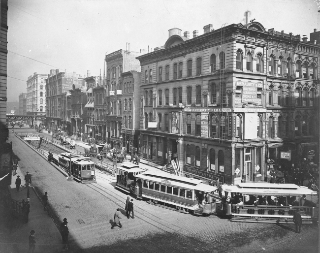
The introduction of cable cars in the 1880s and electric trolleys the following decade increased the intrusion of technology on the street, especially during rush hours. 
On June 6, 1892, the first elevated line called the "Alley L" opened for business, running from Congress Parkway and State Street to 39th Street, along the alley, behind and around buildings and through backyards. Photo from 1893.
The construction of the "L" system between 1892 and 1907 aided this quest for efficiency by creating a whole new layer of streets above the surface traffic. Its downtown structure assumed the name "Loop," initially describing a square of streetcar tracks.

Late-nineteenth-century street life also contributed to the mixed images of Chicago, especially as it was portrayed in illustrated national magazines and travelers' accounts. After the 1871 Chicago Fire, civic leaders were proud to point out how the busy streets reflected rebuilding and rebirth. At the same time, illustrations of the bloody railroad strikes of 1877, the 1886 Haymarket Affair, and the 1894 Pullman Strike focused on street confrontations. They provided a quick stereotype of the instability of society in the mushrooming city. Likewise, the street created an instant impression on such foreign visitors as Rudyard Kipling, who disdainfully described the "collection of Miserables" who daily passed through "turmoil and squash." In 1900, Scottish author William Archer proclaimed, "New York for a moment does not compare with Chicago in the roar and bustle and bewilderment of its street life." 

Similarly, many of Chicago's greatest writers — especially those of rural origin — wove their fascination with the energy and variety of the public spaces, especially downtown, into their works. This is evident in the arrival scenes in novels such as Theodore Dreiser's Sister Carrie (1900). Sherwood Anderson's Marching Men (1917) described how the working poor displayed their misery as they tramped the streets or rode the cars. Chicago-born Henry Blake Fuller's The Cliff Dwellers (1893) described the view from a skyscraper as if through the eyes of a bird of prey looking from its nest down at the street. Streetlife was also prominent in shorter forms of literature. George Ade drew inspiration from peddlers and passersby for his aptly titled column "Stories of the Streets and of the Town," which ran in the Chicago Record (1893–1900). And, of course, the "painted women" of Carl Sandburg's "Chicago," as well as "Clark Street Bridge" and other pieces among his lesser-known poetry, celebrated workaday street life.

In the real world, street life—and expectations about it—became as specialized as the neighborhoods that contained it. Downtown, the display windows of department stores invited pedestrians to pause and ponder. By the 1880s, strangers' guidebooks provided tourists with suggested routes and maps to enable them to wander in search of "the sights." Police, meanwhile, remained vigilant for "mashers," an updated version of corner puppies, which might make the Loop shopping visit unpleasant for women. Outside of downtown, commuting patterns concentrated traffic along certain main streets that linked downtown and the sprawling neighborhoods. Major outlying shopping districts appeared where these heavily used destination travel corridors intersected, such as at 63rd and Halsted 
or Lincoln and Belmont.

Out in the neighborhoods, the patterns of street life varied by class. The poverty levels and congestion in the adjacent housing usually determined the extent of the residents' dependence on public places for their daily survival. The street was home to those at the bottom of the social scale. After the fire of 1871, living in public places had become part of the survival strategy for tens of thousands of temporarily homeless victims, many of whom wandered the city for months. During the depression that began two years later, the first generation of tramps (mobile non-workers) and hobos (mobile seasonal workers) arrived in Chicago because it was the hub of the nation's growing rail network. 

By the end of the century, thousands of unemployed men populated three Skid Row districts that ringed the downtown area. Here, day labor agencies did their hiring curbside. At the same time, the local street life consisted of the denizens of cheap restaurants, barrooms, pawnshops, used-clothing stores, and various hotels ranging upwards of "nickel flops." Amidst them on the sidewalks and streets were such noisy "redeemers" as the Salvation Army band and the Gospel Wagon of the Pacific Garden Mission. It was easy for the more affluent Chicagoans to conflate idlers with the poor, who utilized public spaces as a necessary last resort for survival.

Each step up the economic ladder allowed participation in street activities to become more voluntary. Above the transients, the tenement neighborhood provided more permanent dwellings, although conditions still forced a blurring between private and public distinctions. The street functioned as a verbal communication conduit within largely non-literate communities and a place to work and play. Sweltering nights saw much of the population sleeping on the sidewalks, and evictions cast newly homeless families and their meager possessions onto the curbstones. By 1868 there was already enough homeless youth peddling papers on the streets to justify the creation of the Newsboy's and Bootblack's Home, and their ranks grew. Greedy adults also snatched the earnings of many immigrant juveniles imported during the 1870s to become street musicians.

Mass-produced subdivisions — reached by streetcar and "L" — further increased the social scale by making such bungalow neighborhoods like Englewood affordable with its world of small porches, vegetable gardens, and modest fences. Further up the income scale, the lawns and ornamental fences in such substantial middle-class areas as Ravenswood divided neighbors from the street and each other while children played in parks rather than on the streets. Neighborhood improvement associations also pressured residents to maintain peace and order and beautify their private property, and residents joined private bicycle clubs. Finally, at the top of the social scale, residents of such elite neighborhoods as Prairie Avenue and Astor Street utilized streets primarily for such symbolic activities as the annual opening-day parade to the Washington Park Race Track or for efforts toward public beautification. The wealthy rode in private carriages ate lunch at downtown clubs, and conversed by telephone or at teas, not on the curbstone.

The level of independence from the street helped determine one's social class, and that same space was often the meeting place or interface between social classes. More affluent Chicagoans, who could ride through tenement districts on streetcars, the "L," and commuter trains, came in contact with mainly the poor through the street trades. Peddling, which involved a fantastic variety of goods and services, was the source of economic survival for some and convenience or annoyance for others. Adult immigrants realized that a minimum financial investment and hard work could provide an entree into capitalism and the means to avoid working for someone else. Successful vendors positioned themselves amidst the flow of likely customers. "Shoeshine boys" and news vendors knew where to find male commuters, while fakirs, who generally sold useless trinkets, occupied spots just outside department stores where mothers, who might have felt a bit of guilt at their personal spending, might be tempted to buy something for their children. 

Similarly, teamsters maintained street stands near furniture retailers and other large ticket items, while hacks (unregistered taxis) cruised near the depots and hotels. Street trades on the edge of legitimacy and beyond also knew the importance of location. Years of contact with the street brought an understanding of traffic flow: a location outside of train stations, for instance, was ideal for collecting donations from sympathetic rural travelers. Streetwalkers (prostitutes) peddled sex in public places, and their customers mutually discovered places where they did not draw unnecessary attention to themselves.

Other types of vendors learned the most productive routes through residential neighborhoods. Street peddlers bought food that was often near the end of its shelf life from wholesalers and carried it to poorer districts that were too far from marketplaces for housewives to visit in person. Such mobile services as knife and scissors grinders alerted neighborhoods of their presence by the sound of a bell. Recyclers of various kinds also worked their way through the neighborhoods. Rag pickers, metal buyers, and other scavengers resold their findings at a profit because bottles, cloth, and even castoff cigar stubs could be recycled into new products. The specialties that developed in this economic street life mirrored the city's ethnicity, with Italians dominating produce sales, Greeks as confectioners, Jews in recycling trades, Dutch in scavenging, and Germans in handyman services. But what was a convenience to the working class was a nuisance to the more affluent, who valued privacy and wanted peddlers banned from their neighborhoods.

This hierarchy of class and privacy explains much about the nature of street life but superimposed over the story were the temporal rhythms that determined the ebb and flow of activity. In the predawn hours, hundreds of workers bought and sold produce at the Randolph and South Water Markets while lamplighters turned off gas jets and crews from the city and the Municipal Order League watered and swept the surfaces. The morning rush hour saw factory workers walk to work and thousands of vehicles cross the bridges into the Loop. Women shoppers began to appear on the streets later in the morning, while the noon hour saw thousands of downtown employees and shoppers pour out of buildings in search of lunch.

sidebar
At the turn of the 20th century, restaurants grouped together in downtown (the Loop) Chicago. The reason is not hard to understand. Groups of the same kind of restaurants attracted flocks of lunch customers who knew they were likely to find something they wanted to eat. Chain restaurants were becoming common and lesser-known restaurants were eager to locate near the successful, established eating establishment6s to catch their overflow. It was also used as a marketing ploy as City officials nicknamed streets of similar-style restaurants called a "row" to help boost the local economy.
  • Cafeteria Row: Wabash Avenue had the largest number of self-service restaurants in the world. 
  • Dinner Pail Avenue: Near North Milwaukee Avenue.  
  • Restaurant Row: Randolph Street, where there were 39 busy restaurants within a six-block stretch.
  • Toothpick Row: Clark Street had lots of lunchroom businesses.
In the mid-afternoon, women shoppers left downtown to be home when their children returned from school. Then began the evening rush hour of streetcars and pedestrians. Workers walked home along "Dinner Pail Avenue" near north Milwaukee Avenue, where there were many reasonably priced diners and restaurants.

The character of street life changed after the dinner hour. In the patchwork of ethnic neighborhoods, children played in the roadway while their parents conversed on stoops and curbstones. Some workers left for all-night factory shifts. In warm weather, middle-class bicycle riders took to the outlying streets. But the deepening darkness also increased the fear of crime. Chicagoans thought many tough neighborhoods were safe enough to pass through in the daytime but dangerous at night. Newspapers reported frequent muggings near the ends of streetcar lines and at open bridges and described the night as dominated by criminal elements. Downtown, there were sharp contrasts. Diners and theatergoers filled the "bright light" Randolph Street district late into the night, while the nearby Levee district hosted a lively street life around the clock. But after the cleaning crews departed, the large office blocks became what one newspaper called the "loneliest place in Chicago."
Vice Districts of Chicago's Article.
The street's life reflected other life cycles, including age and seasonality. Cold weather drove indoors all but the heartiest peddlers of necessities while others restocked with holiday merchandise. Transit lines utilized closed-side equipment, heated by stoves, instead of the open-style cars, which brought summer riders close to the sounds and smells of the street. The street also meant different things to people near the beginning or the end years of life. The street was a micro-environment of socialization where youths set their own rules and learned the ways of the world. Their games and songs were a part of city folklore. Youth gangs, however, had already begun battling for domination of neighborhood turf by the mid-nineteenth century. At the other end of the spectrum, aged Civil War veterans came to the Loop post office to collect their monthly pension checks, and many elders sold newspapers or worked at such jobs as "baby watchers" outside of outlying department stores.

THE NEW AGE OF THE STREET
By the turn of the century, several factors were already beginning to transform the streets and create a more restrictive attitude toward them. First, various reform efforts attacked inner-city street life as the locus of the city's social problems. Laws were enforced in the red-light districts. Middle-class reformers joined economic elites to separate the poor from public places. Curfew and truancy laws were aimed not only at eliminating child labor but also at keeping children off the streets; the Special Park Commission created dozens of inner-city playgrounds with the same goal. Reformers also became increasingly hostile to street peddlers, condemning them as public health hazards, loiterers, and disorderly and intrusive obstructions to traffic flow. New health laws banned outdoor dining and the vending of perishable food avoiding contamination from dry clouds of airborne horse manure.

At the same time, decades of urban growth had fostered the process of sorting urban functions by land use (wholesale, retail, residential), social class, and ethnicity. The heterogeneous urban mixture of the mid-1800s had given way to a pattern of more homogeneous districts of social classes and neighborhoods. Citywide anti-noise laws were aimed at silencing obtrusive peddlers and imposing quietude and order in middle-class neighborhoods and the Loop. In 1913 the city began an effort to push all street trades out of middle-class areas and into the Maxwell Street district. At the same time, enforcing anti-loitering laws gradually drove the transient population into Skid Row districts to the north, south, and west of the Loop. The goal of these efforts was a more orderly street life that was confined to what was deemed appropriate districts.

Finally, the efficiency of crowd control during the 1893 World's Columbian Exposition inspired Chicagoans to believe that they could impose a similar sense of beauty and order on the rest of the city. 
World's Columbian Exposition - Chicago Day, October 9, 1893 
Infrastructure innovations included newly designed bridges, and the elevation of steam railway tracks to remove crossing hazards. But nothing symbolized the desire for aesthetic and efficient streets more than Daniel Burnham's Plan of Chicago (1909)

Its emphasis on traffic flow countered the traditional working-class social uses of the street. The plan's impressionist-style illustrations by Jules Guerin emphasized the celebratory city as if viewed on a warm Sunday afternoon. Meanwhile, a series of statues financed by the Benjamin F. Ferguson Fund stressed the streets' artistic rather than survival possibilities. Beauty and efficiency, which were supposed to contribute to the economy by making workers happier and more contented, also represented a triumph of the middle and upper-class view of what street life should be.

With its unimpeded traffic flows, Burnham's plan also represented a transition into the automobile age, dramatically changing the relationship between Chicagoans and their streets. The auto not only benefited from the growing disdain for the street by providing the kind of isolation from street life that had once been enjoyed by only the wealthy but cars and trucks also accelerated other changes. Their gradual displacement of horse-drawn vehicles, in turn, displaced animals — along with manure and dead carcasses — which had been a regular part of street life. Drivers also demanded speed and the elimination of peddlers, plodding wagons, playing children, or any other street use that interfered with getting from here to there. 

By the 1920s, the growing volume of fast-paced traffic produced intersection hazards that encouraged the introduction of mechanical traffic signals; this, in turn, resulted in the displacement of hundreds of traffic officers, another normal part of street life. Even then, auto fatalities, which had already soared to 302 in 1918, included many pedestrians. The extension of Ogden Avenue from Chicago Avenue to Armitage at Lincoln Park symbolized a new attitude. In the quest for an efficient way to link the West and North Sides, the roadway slashed through existing neighborhoods and scaled Goose Island with a lofty bridge. That same attitude that almost any part of the built city might be expendable was present in early plans for wide, limited-access roadways. The idea of the street as a place for getting from here to there was about to triumph.

But hints of the former uses of the street would not disappear. During the Great Depression, the public ways again became a means of survival. Jobless thousands flocked to Chicago for work but ended up utilizing the street as an employer of last resort. Some of the newly homeless sold apples; others took jobs on government public works projects that built hundreds of miles of new infrastructure.
The Truth About Al Capone's Soup Kitchen at 935 South State Street, Chicago, Illinois.


That ended during World War II when the streets once more assumed a unifying and celebratory role. Downtown State Street became an outdoor museum of military equipment, while the LaSalle Street side of City Hall became "Victory Square," a scene of patriotic rallies. In the neighborhoods, civilian defense exercises, flagpole signs, and memorial shrines promoted unity, as did the countless parades that wound through every part of the city.

After V-J Day (
Aug. 14, 1945) — when the streets were once more used to celebrate — and the period of postwar recovery of the national economy, the street became a barometer of another kind of urban transformation. Pundits predicted that urban renewal, high-rise apartments, air conditioning, and television would kill off neighborhood street life. The newspaper box, for instance, displaced hundreds of human vendors, partly because the general decline in public transit ridership put so many former pedestrians into autos. The idea of the street as an employer of last resort survived in impoverished neighborhoods. Peddlers elsewhere became such a rarity that the once-ubiquitous scissors grinders' visit became the subject of great excitement. 

During the 1950s, the press noted a loss of neighborhood social life traditionally grown out of public places. The front porch or stoop, which had fostered neighboring on warm evenings, had begun to give way to air conditioning and television. And in the poorest neighborhoods, high-rise public housing completely destroyed the role of the street in the community.

The expressway system, which removed much of the traffic from the major city thoroughfares, represented the near triumph of the idea of the single-use street: the only possible function was as a place for cars to drive. (Chicago created an ingenious exception by routing rapid transit down the otherwise-useless median strip.) Neighborhoods that lay in the way were now regarded as irrelevant piles of rubble-to-be, and the older transient districts were flattened to make way for superhighways. 

Meanwhile, at the other end of the auto commute, the mass production of a limited number of house designs in booming suburbia was reflected in the mass creation of quiet residential streets. Juvenile trees matched tricycles and other juvenile transportation equipment. Sociologists noted that cul-de-sacs favored neighborliness. Even the temporal rhythm of the suburban street was different. Rush hour dominated the clock, although the shopping centers that displaced older commercial streets were now open evenings.

Meanwhile, the street life of downtown Chicago fell into decline, as the boast that State and Madison was the "world's busiest corner" disappeared during the 1960s and '70s. Loop department stores were partly displaced by suburbia and the rise of North Michigan Avenue as the high-end street for strolling and window shopping. As downtown streets began to empty out after dark and the Loop took on the unwarranted reputation of being unsafe, movie distributors helped to drive away the street life. They had formerly released new films in downtown theaters weeks before they arrived at outlying screens; when they began distributing them everywhere, the Loop theater crowds disappeared. 

In 1968 the term "Streets of Chicago" took on connotations of disorder similar to those of 1877, 1886, and 1894. In desperation, the city rebuilt State Street into a mall, a misplaced suburban model that failed to bring people back.
State Street Mall Illustration. 
But even during this low point, there had been a few hopeful signs. Mayor Richard J. Daley revived the downtown St. Patrick's Day Parade in 1956, an important symbolic gesture, while Chinese, Germans, Greeks, Poles, and others also used the streets for celebrations. Triumphs achieved by Chicago sports franchises and the symphony, astronauts, and other dignitaries prompted massive parades. Meanwhile, newly arrived Latin American and Asian ethnic groups quietly brought with them their celebratory processions and parades, as well as a strong tradition of street trading. And the taxicab industry continued to allow the kind of low-capital entry into American entrepreneurship for immigrants that street trades have always provided to newcomers.

Neighborhood block parties and the gradual return of outdoor dining were the first signs of how the booming economy of the late 1980s and 1990s and a gentrified inner city would bring about a revival of activity. New office towers and converting factories and warehouses into apartments nurtured a revival of center-city dining. But contemporary street life only hints at the wide variety of activities that were once there. What returned was closer to the "city beautiful" of the Burnham Plan than to the workaday intensity of the late nineteenth century. ChicagoFest, followed later by the Taste of Chicago, the Blues, and Gospel Music Festivals, and a patchwork of neighborhood festivals, represented a highly particular new form of 'Disneyfied' street life, carefully planned, advertised, predictable, sanitized, and policed.

During the late 1990s, many of the last remnants of the old street life were threatened. Police removed the homeless from Lower Wacker Drive while gentrification nibbled away at the old south and west transient districts. The demise of SRO (Single room occupancy) hotels and the charities that supported their tenants resulted in the removal of most transients, many of whom had been dumped from state institutions. Meanwhile, campus expansion at the University of Illinois at Chicago ended the storied Maxwell Street Market. At the same time, the city launched a crackdown on ethnic food street vendors, proclaiming them a nuisance and health hazard.

Compiled by Dr. Neil Gale, Ph.D.

Lost Communities of Chicago - Shanty Town and the District of Lake Michigan. (aka The Sands; Streeterville)

Captain George Wellington Streeter
George Wellington Streeter was born in Flint, Michigan, in 1837. Before the Civil War, he wandered the Great Lakes region, working at various times as a logger and trapper, an ice cutter on Saginaw Bay, a deckhand on Canada's Georgian Bay, and a miner. 

He married his first wife, Minnie, and then traveled west in a covered wagon, returning to Michigan on the eve of the Civil War. He joined the Union Army as a private and served in the Tennessee theater.

After the war, he became a showman, lumberjack, and steamship operator. After his wife left him (she ran off with a vaudeville troupe), he came to Chicago in the mid-1880s and married again. 

He and his new wife, Maria, decided to become gun runners in Honduras. Streeter bought a steamship and named it "Reutan." 

Before piloting it down to Central America, Streeter took a test cruise in Lake Michigan in 1886 during a gale. The ship ran aground about 450 feet from the Chicago shore.
The Steamship "Reutan" docked on the Chicago River.
In the days that followed, Streeter surveyed the situation and decided to leave his boat where it was. At the time, Chicago was amidst a building boom after the great Chicago fire of 1871. Streeter found excavation contractors who were eager to pay a fee for the right to dump fill on the beach near his boat. 

He eventually amassed 186 acres of newly created land. Consulting an 1821 government survey, Streeter determined that his man-made land lay beyond the boundaries of both Chicago and Illinois and therefore claimed that he was homesteading the land as a Civil War veteran.


Unfortunately, prominent Chicagoans such as Potter Palmer and N.K. Fairbank owned the land adjacent to Streeter's land accretions. These men claimed that Streeter was a squatter and had no legal rights to the land. Streeter argued differently, declaring, "When I come here ther warn't a particle of land for me to squat on!"
Sensing that his enemies would try to oust him, Streeter replaced his ship with a homemade two-story tar-paper "castle." The first floor was his war room; the second floor was his residence.
Captain Streeter's Converted Boat Fortress/Home
When private detectives and thugs attempted to serve allegedly specious warrants on Streeter, he and his wife responded with sawed-off muskets filled with birdshot. On one occasion, Streeter's wife drove off three deputies by dousing them with boiling water.
Click for a full-size map.
Several times, assailants were killed during their attempts to storm what Streeter called his "District of Lake Michigan." But the city found it challenging to keep Streeter in jail, and one time he was acquitted of self-defense. 

Another time he proved that the birdshot in his rifle could not possibly have killed the policeman found with a piece of lead in his heart. When he was arrested for refusing "to disperse," he successfully argued in court that he could not disperse as he was only one person. 


But in March 1902, John Kirk, an imported Western gunman, was killed in Streeter's district. Streeter was convicted of murder and sentenced to life in prison, and Streeter claimed he was framed; the governor of Illinois agreed and pardoned him nine months later. But while Streeter was in prison, his wife died.


Streeter resumed control over his domain. To finance his side of the battle, Streeter sold lots to upward of 200 prospective homeowners, as well as refreshments, alcoholic beverages, and snacks to real estate shoppers and the just plain curious. 


Unable to oust him by force, his foes turned to the courts. However, the law of riparian rights was murky, and Streeter's lawyers - paid with deeds of land - proved to be able adversaries. 


Streeter offered various theories about why the land belonged to him in real life. Sometimes he claimed it by squatters' rights, and other times he'd bought a deed from a mysterious John Scott "someplace in Michigan."

The longest-running explanation was a purported land grant from President Grover Cleveland that Streeter waved in front of judges for 25 years — until, that is, a handwriting expert took the witness stand in a 1918 trial and put a chemical test to the document's signatures, as the Tribune reported. "Lo and behold, the signature of Cleveland faded away, and there arose in its place the quaint and sturdy signature of President Martin Van Buren!" Streeter's name vanished by a similar process, revealing the actual grantee was Robert Kinzie, a pioneer Chicagoan. The judge ruled that the document "was and is now a clumsy forgery," adding that weather bureau records showed no evidence of a storm the night Streeter claimed to have been shipwrecked.

But finally, shortly after his arrest in 1918 for selling liquor without a license and assault on a police officer, agents of Chicago Title and Trust Company, armed with warrants, put the torch to Streeter's castle. 
By now, Streeter had married a third time, and his wife, Emma "Ma" Streeter, charged the group with a meat cleaver, but to no avail, and the couple retreated to a nearby boat to wanly continue the fight. He never returned, and Streeter spent the next few years operating a floating hot dog stand in East Chicago. The old rogue died on January 24, 1921, at age 84.

Many dignitaries, including William Hale Thompson, the mayor of Chicago, attended his funeral. His wife continued to wage war both inside the courtroom and on the shores of Lake Michigan. In 1925 the federal district court in Chicago ruled that because Streeter never divorced Minnie, his first wife, "Ma" Streeter, was not legally married and thus ineligible to file claims for Streeter's property. The last suit brought by alleged heirs was dismissed in 1940, thus finally ending a half-century of colorful warfare and litigation concerning the sovereignty of the District of Lake Michigan - to this day still called Streeterville, in honor of its founder. 
Shows Expanding Chicago Shoreline by Year. 
The land that Streeter so ardently fought for is now the most expensive part of Chicago. It is on the Near North Side of the city, bounded by Oak Street on the north, Michigan Avenue on the West, Grand Avenue to the south, and Lake Michigan on the east.

Today this area is a named neighborhood called Streeterville. The property continues to be valuable, and the John Hancock Center now towers where the Reutan fortress used to be.
A statue of "Cap" stands at Grand Avenue
and McClurg Court, Chicago, Illinois.
Read Captain Streeter, Pioneer. Published in 1914.

Compiled by Dr. Neil Gale, Ph.D. 

Monday, November 28, 2016

Downtown Chicago's "Cow Path" from 1844 is still Protected by Law.

Mz. Udders


To get the history of how this "Cow Path" came to be, one must go back to 1833, when Chicago was incorporated as a town on August 12, with a population of about 350 inhabitants. 

After working as a carpenter on the Erie Canal, Willard Jones, an early settler who migrated from New York, decided to make this town his home. For $200 ($8,225 in 2024), Willard purchased several plots of land in today's Chicago Loop business district.

The area of Clark Street on the east, LaSalle Street on the west, Monroe Street on the south, and Washington Street on the north in Chicago equals 33 acres.

sidebar
The average cost for Willard Jones property today (2025) would cost $10.3 Million per acre, or $340 Million for 33 acres of land without any improvements.

Willard built a farmhouse and some outbuildings in the 1830s and successfully worked the land while building a dairy barn. The terrain remained unchanged for many years.

Chicago was incorporated as a city on March 4, 1837. As the population started to grow and early industry emerged, real estate began to gain in value as early developers looked for ways to utilize land in ways more profitable than agriculture. In response to this phenomenon, Jones started selling off parcels of his land in 1844 in the surrounding vicinity of what today encompasses Clark Street on the east, LaSalle Street on the west, Monroe Street on the south, and Washington Street on the north. Some of the original commercial properties in downtown Chicago were eventually erected on this land, which ultimately planted the seeds for the birth of the Loop business district.

Jones sold the southern portion of his property to Royal Barnes in 1844, and Jones continued to operate a smaller version of his farm near the present-day intersection of Clark and Monroe. Jones sold the northern half of his original property to Abner Henderson two years after the Barnes sale. Written into the property deed was a provision that Jones would have access to Monroe Street via a 10-foot wide corridor west of the Barnes land to take his cattle from farm to pasture, just to the south, where the Board of Trade now stands. 

No construction was permitted which would obstruct this cow path in any way. As downtown Chicago began to develop over the upcoming decades, the easement was legally binding by the Illinois Supreme Court in 1925.

sidebar
The cow path is a public easement which is a legal right that allows the public to use a property for a specific purpose. Once a public easement is created, it cannot be abandoned or taken away. Therefore, the cow path is still a public easement, and anyone is legally entitled to use it to herd cows, even if it passes through private property.

In 1927, the owners of the old Barnes property were ready to erect a 22-story office building at Monroe and Clark. By then, they'd acquired title to the 10-foot corridor. However, the owners of the Henderson plot to the north still had that right-of-way guarantee and refused to surrender it. The courts ruled that work could proceed on the Barnes property only if the access corridor was retained. So, architect Frank Chase redrew his plans. Ultimately, the 100 West Monroe Building was constructed with an 18-foot-high tunnel through its western edge, big enough for any farm animals or hay wagons passing through the Loop.
November 26, 1932 - This photo shows the cow named Northwood Susan Sixth being milked on her arrival at the end of the historic cow path, which can be seen behind her.
To celebrate this unique attribute, Mayor Edward Kelly affixed a bronze plaque on this portion of the building proclaiming the tunnel was "reserved forever as a cow path" in 1937. 

The Plaque Reads:
Historic Cow Path: This areaway 10 x 177 x 18 feet is reserved forever as a cow path by the terms of the deed of Willard Jones in 1844 when he sold portions of the surrounding property. Erected by Chicago’s Charter Jubilee and Authenticated by the Chicago Historical Society, 1937.
While the plaque is long gone and unaccounted for, this unique bit of Chicago history still exists today. However, in 1969, when the Two First National Plaza Building was erected at 20 South Clark, it blocked off the northern end of the cow path.

According to a 1979 Tribune article, both Chicago Title & Trust and the Chicago Historical Society declared that "the action was legal, and there doesn't seem to have been any court challenges to it."
When the Hyatt Corporation began converting the 100 West Monroe building into a hotel, Chicago historians feared the cow path would be obliterated. Happily, hotel management has a sense of history preserving it. Hyatt also has a sense of whimsy; one of the hotel's conference rooms is named WILLARD JONES
You can still use the cow path tunnel as a shortcut to LaSalle Street.

sidebar
Chicago held a "Cows on Parade" public art project  in 1999, following Zurich, Switzerland which held the first  public "Cows on Parade" exhibit in 1998.  Over 300 life-size fiberglass cows were decorated by local artists and placed throughout the city. The cows were on display for several months and then auctioned off, with the proceeds benefiting local charities. The project was a huge success, attracting millions of visitors and raising over $3 million for charity.

The project has been held in over 80 cities worldwide since Chicago began this art form  and fund raising trend in 1999. 

Some of the other U.S. cities were: New York City, New York (2000), Stamford, Connecticut (2000), Kansas City, Missouri (2001), Houston, Texas (2001), Portland, Oregon (2002), Harrisburg, Pennsylvania (2004), Denver, Colorado (2006), and San Diego, California (2009). 

Chicago's idea caught on Internationally; Manchester, England, UK (2004), Edinburgh, Scotland (2006), Toulouse, France (2012), Perth, Western Australia (2014), Mississauga, Ontario, Canada (2021), and Toronto, Ontario, Canada (2022)

Compiled by Dr. Neil Gale, Ph.D.