Thursday, April 26, 2018

South Water Street, Chicago, beginning in the 1830s.

This is a rare view looking west on South Water Street, possibly in the early 1830s. Hogan's store was at South Water and Market Streets, while Wolf Point Tavern can be seen in the distance. (from a painting owned by the Chicago History Museum.)
The very first street Chicago ever had was a muddy, narrow trail running east and west along the south bank of the Chicago River, and its name described it as South Water Street. Along this street, the first markets and general stores were built, eventually becoming a gigantic produce market, only to be replaced by what is known today as West and East Wacker Drive. 

In 1833, when Chicago received its charter as a village, Lake Street was the town's main street; this same year, the first Tremont House was erected at the northwest corner of Dearborn and Lake streets. The first store building on Lake Street, a two-story frame structure, was built by Thomas Church. The first Court House followed in 1835, and the City Hotel, later the Sherman House, in 1837. From 1837 to 1842, the first City Hall was located in the Saloon building.
The "Saloon Building" was a three-story brick building erected in 1836 by Capt. J.B.F. Russell and George W. Doan at the Southeast corner of Clark and Lake streets. It was named after the French word salon, meaning a small reception or meeting hall, not a drinking establishment.


One of the country roads that came into the old Fort Dearborn settlement from the northwest was an Indian trail that was planked by the early settlers of the area to hold their wagons up from the bottomless mud. It was called the Northwest Plank Road. The original Indian trail name was the Milwaukee Trace, now known as Milwaukee Avenue.

The first road, crossing the "Dismal Nine-Mile Swamp," went west on Madison Street to Whiskey Point (Western Avenue), then southwesterly on the Barry Point Trail to Laughton's Tavern, where it forded the DesPlaines River and went southwest to Walker's Grove, now Plainfield. Portions of it still exist as Fifth Avenue in Chicago, Riverside Drive and Longcommon Road in Berwyn and Riverside, Barry Point Road in Lyons, and Plainfield Road from Ogden Avenue to Plainfield.

There is a dispute about the route taken from Chicago to Widow Brown's house in the woods on the north branch of Hickory Creek (east of Mokena). One historian asserts that it went southwest (on Archer Avenue to Justice Park), thence southerly through the Palos forests and across the Sag valley to about 151st Street , and thence southwest on what later became the Bloomington State Road. Others assert that it went southward on State Street and Vincennes Avenue on the road to Blue Island and thence southwesterly on what is now the Southwest Highway. These and other dirt roads were superseded or improved by the makeshift construction of plank roads which, although temporary, contributed much toward the growth of infant Chicago.

South Water Street, Wholesale District
After the 1871 Chicago Fire, many offices that had once been near the river moved farther south into the expanding commercial downtown, and South Water Street (which is presently located just north of Lake Street between Wacker Drive & Stetson Drive) became home to the city's central produce market. It was fairly accessible to the rail yards and, most of all, was backed up to the docks where many incoming vessels could bring fruits and vegetables from the states located around the Great Lakes. Michigan was a great supplier during the warm months. Cherries, celery, apples, plums and other fresh commodities were put on boats from Benton Harbor, St. Joe, Ludington, Traverse City and other Michigan port cities and shipped to the South Water Market.
Note the wooden sidewalks and dirt roads. The wood planks on the left sidewalk were to cover up rain gutters and support delivery wagons.


By the turn of the century, reformers and planners, over the objections of some Chicagoans, urged that the gritty and heavily trafficked area be cleared out as an unsightly intrusion to the downtown that created unnecessary congestion in the heart of Chicago and blocked access to the river. In addition, the market had become too cramped for a city of Chicago's size.
As part of the building of bi-level Wacker Drive in the mid-1920s and the accompanying of a walkway along the riverfront, the city leveled the buildings in this area. It moved the wholesale produce business to the new South Water Market, bounded by Racine Avenue on the west, Morgan Street on the east, 14th Place on the north and the railroad on the south.
To make room for the new South Water Market, deteriorated existing houses were bulldozed in this high-crime neighborhood called The Village. In 1925, the approximate 13 acres of land and buildings cost around $17 million. It took 6 months to complete, and there were 166 stores or units. They designed the streets to be 10 feet wide and the alleys at 42 feet. It was expected that the new market would service Chicago well for at least the next 25 years. Soon it was discovered that the streets needed to be wider, and the market became severely crowded.

The time came again in 2003 for the market to move. The name changed to the Chicago International Produce Market, conveniently located off Damen and I-55. It is a state-of-the-art facility, and many merchants are the third or fourth generations in the family business.

Compiled by Dr. Neil Gale, Ph.D. 

Tuesday, April 17, 2018

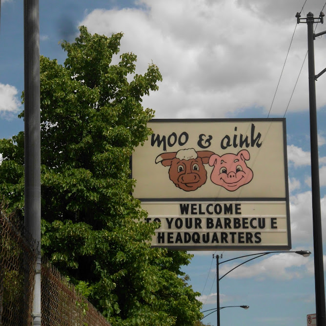
The History of Moo & Oink Grocery Chain of Chicago, Illinois.

Moo & Oink was a southside Chicago-based grocery store chain and wholesaler that catered to the inner-city community and south suburbs.
Originally named the Calumet Meat Company, the company was renamed Moo & Oink in 1976. Moo & Oink had three stores in Chicago and one in Hazel Crest.
It became well known for its odd late-night television commercials that ran in the 1980s and mid-1990s, usually featuring dancing people in cow and pig costumes. The commercials often featured a jingle that started off with: "Moo and Oink! Moo Moo Moo!" and eventually ended with a famous sign-off, "Moooooooooooooo & Oink!"

MOO & OINK 1987 TV COMMERCIAL

The First Isle in Moo & Oink, 2004.
In 2005, Tina Fey and Amy Poehler sang the Moo and Oink jingle on the "Weekend Update" portion of Saturday Night Live to prove to Scott Podsednik that they were native Chicago White Sox fans.

MOO & OINK JINGLE

Moo & Oink is famous for its Chicago-style hot links and hand-cleaned chitlins. 

In April 2010, they revealed a new company logo, replacing the classic cartoonish cow and pig logo with an animated but realistic-looking animal logo. 
All Moo & Oink stores closed in 2011, after the company went into Chapter 7 bankruptcy, though there was interest in buying and resurrecting the company. By the end of the year, the brand and trademark were sold to Best Chicago Meat, and the stores remained unsold. 


Compiled by Dr. Neil Gale, Ph.D. 

Wednesday, April 4, 2018

Celebrating "Chicago Flag Day" on April 4th.

CHICAGO INCORPORATION DATA
James Thompson surveyed Chicago, filing the plat on August 4, 1830. This action was the official recognition of Chicago's location. 

Chicago was incorporated as a town on August 12, 1833, with a population of about 350. 

With a population of 4,170, the town of Chicago filed new Incorporation documents on March 4, 1837, becoming the City of Chicago and the world's fastest-growing city for several decades.

CHICAGO FLAG DESIGN EXPLAINED
In 1915, Chicago Mayor Carter Harrison, Jr., decided that the time had come for Chicago to join the dozens of other American municipalities that had adopted an official flag. The 1893 World's Columbian Exposition had come and gone with only a red banner emblazoned with a white pall (Y-shape) to advertise the city's "municipal colors" (the Y-shape would also be employed in the city's less recognizable "Municipal Device").


Harrison's flag commission received more than 1,000 proposals before settling on a design submitted by Wallace Rice, a lecturer in heraldry and flag history at the Art Institute of Chicago. Rice's original design only incorporated two stars, symbolizing the 1871 Chicago Fire and the 1893 World's Columbian Exposition.
Rice chose six-pointed stars to distinguish them from the five-pointed stars commonly seen on national flags; the points formed a 30-degree internal angle to mark them as distinct from the Star of David. He aligned them to the staff (left) side rather than centering them, assuming city officials might wish to add more stars later. 

The city did that in the 1930s, adding two more stars (symbolizing the 1933/34 Century of Progress Exposition and Fort Dearborn). There have been numerous campaigns to add a fifth star to honor everything from Chicago's role in creating the atomic bomb (Fermilab, Batavia, Illinois) to Chicago's history with the Special Olympics. 

The current form has remained unchanged since 1939.

Compiled by Dr. Neil Gale, Ph.D. 

Sunday, March 18, 2018

The Frank Long House of Oak Park, Illinois.

Frank E. Long, a publisher from downstate Illinois, was born in 1865. By the standards of the time, he was already an elderly man when he commissioned architect Leon Stanhope to design his house in 1924. Long began his career downstate working for a manufacturer of agricultural implements and became the company's representative for publicity in Chicago, necessitating a move to the area. He eventually became vice president of operations. One of the company's publications lists Long's hobbies as motoring and fishing. He lived in several Oak Park homes before hiring Stanhope to build the 401 Linden Avenue house.
In a suburb made famous for Prairie design and Frank Lloyd Wright residences, the Long House stands apart in its architectural heritage. The cottage style home looks as if it should be sitting on a rolling hill in the English countryside, rather than the western suburbs of Chicago. 

Leon Stanhope, the Chicago-based architect behind the Long House's singular style, was a contemporary of Wright, but rather than embracing the new Prairie Style, he looked back in time in designing a home that combines the charm of a pastoral dwelling with the grandeur expected of a home in the estate section of Oak Park.
The wavy roof has earned the home the nickname the "hobbit house" because of its resemblance to a tiny dwelling that seems to rise from the ground, sporting a roof made of natural materials. While the home's distinctive roof appears to be made of thatching, it is, in reality, constructed of wood.
Often, these types of roofs are made up of steamed cedar shingles, which have the ability to be shaped in curved formations. A custom gutter system and a certain amount of creative underlying construction are also required to support the heavy materials.

The roof is a large part of what makes the Long House an example of the storybook style that was popular for a brief time in the 1920s. Very few homes of this style were built in the western suburbs and the Long House's large size makes it unique for what is usually considered a style represented by much smaller homes.

The house has four bedrooms and 4 1/2 baths which sits on 0.83 acres. It's 3,722 square feet sold in 2014 for $1,800,617.

Compiled by Dr. Neil Gale, Ph.D. 

Monday, February 12, 2018

Freedom Village, Illinois was America’s first Negro town founded in the early 1820s. Renamed Lovejoy, it's now called Brooklyn, Illinois.

In the early 1820s, "Mother" Priscilla Baltimore and her husband John led a group of eleven families, composed of both fugitive and free blacks, to flee slavery in St. Louis, Missouri. They crossed the Mississippi River to the free state of Illinois, establishing a freedom village in the American Bottom, naming it Freedom.

"Mother" Baltimore was said to have purchased her freedom as an adult from her master, a Methodist minister, and saw to it that religious faith would be one of the guiding pillars of her new community. She also hoped the community would be a refuge for others fleeing slavery. She also bought the freedom of members of her family. Born in Kentucky, she tracked her white father to Missouri and bought her mother's freedom from him.
1940 Aerial Photo of Brooklyn, Illinois.
Shortly after forming their new settlement, the townspeople were visited by Bishop William Paul Quinn, a missionary minister for the African Methodist Episcopal (A.M.E.) Church. After meeting with the families in the Baltimore home, Bishop Quinn helped found the Brooklyn A.M.E. Church in 1825. In addition to its public role as the community's church, Brooklyn A.M.E, later renamed in 1839 to Quinn Chapel A.M.E. Church, became part of a network of A.M.E. Churches that formed the Underground Railroad in Illinois. Tunnels still exist under the building that at one point secreted fugitive slaves.
Quinn Chapel A.M.E. Church, Brooklyn, Illinois.
The location of Brooklyn on the Mississippi River across from St. Louis, Missouri, helped its residents to become financially independent, providing opportunities for brick masons, carpenters, coopers, and boatmen. Nonetheless, the economic activities of blacks in Illinois were restricted by the Illinois Black Codes, enacted when the state joined the Union in 1818. These laws restricted the occupations blacks could pursue, virtually eliminated their civil rights, and controlled the entry of new blacks into the state. Aiding runaway slaves was a felony under the law, and authorities could expel any black who could not maintain an income.  
"Mother" Priscilla Baltimore Headstones.
In 1837, five white abolitionists platted the land and created an unincorporated, nearly all-black town. Thomas Osburn was one of them, documented as having lived in the area for decades. Priscilla Baltimore built a house on his former land, which she occupied from 1851-1872. In the 1840s and 1850s, the black population of the village was about 200. The white settlers dominated the town politically since blacks in Illinois were not allowed to vote. Still, it wasn't until 1886 that black voters, as the majority of the local electorate, regained political control of the town. 

Regional capital investment largely bypassed Brooklyn in the competing East St. Louis, Illinois, which gained the all-important railroad connection. Other white-majority towns also benefited by being part of the network of investment. "Almost none of the all-Black towns obtained a railroad." The small village soon became all black.

In 1891, then-Mayor Evans dedicated the town's new post office named Lovejoy (after the abolitionist Elijah P. Lovejoy, who had been assassinated in Alton, Illinois, in 1837). The later high school was also named after him. Black autonomy did not automatically yield unity in the village. Tensions ran high with class and color conflicts by the early decades of the twentieth century and evidence of political corruption. In addition, with the growth in the number of young, single male workers attracted to industrial jobs, the demographics changed, and family life in the village declined.

Archeological and Historical Research
A state archeological survey was required before construction of the Stan Musial Veterans Memorial Bridge between St. Louis and Illinois, which would require realignment of part of Rte. 3 near the village. In 2002, work revealed extensive prehistoric artifacts, so many that the researchers named the site "Janey B. Goode" after the popular Chuck Berry song, "Johnny B. Goode." This site lies within Brooklyn's incorporated limits but just east of the historical residential part of town. It lies along the southern margin of the Horseshoe Lake meander just north of the East St. Louis Mound Group of earthworks. By the end of the 2007 field season, the team had excavated 7,000 prehistoric features, making this one of the largest sites ever excavated in the U.S.A. Most of these features are associated with the Late Woodland Patrick phase and early Terminal Late Woodland Lloyd phase, approximately from 600 AD to 1200 AD. They suggest a more complex and dense indigenous community than researchers had known lived in the area.

In association with its work, the Illinois State Archaeological Survey (ISAS) (formerly ITARP), a joint project of the state and the University of Illinois, conducted outreach with the village of Brooklyn, volunteering to survey some of the areas associated with its early 19th-century history. A team of archaeologists led by Dr. Joseph Galloy found evidence of early Negro occupation from 1830 to 1850, as well as material in other areas from 1850 to 1870. This discovery suggests that the remains of Mother Baltimore's Freedom Village survive beneath the surface in Upper Brooklyn. It also means that artifacts and other evidence of the town's founding may be revealed if additional excavations are conducted there. This would enhance the town's historical significance and research potential.

Since the turn of the 21st century, residents have rallied around new work related to documentation of the village's rich historical past. They have worked to collect oral histories and personal accounts of the town. In 2007, residents founded the Historical Society Of Brooklyn, Illinois. The historical society, together with the ISAS' Drs. Joseph Galloy, Thomas Emerson, Miranda Yancey, Dr. Chris Fennell of the University of Illinois, and the Illinois State Museum are working to preserve the history of Brooklyn.

ISAS also helped the historical society to review documents to locate "Mother" Priscilla Baltimore's unmarked grave at Bellefontaine Cemetery in St. Louis. In September 2010, the Brooklyn Historical Society installed a gravestone in her honor at the cemetery. In addition, ISAS will assist the village in surveying the Brooklyn cemetery to detect gravesites and try to document the history.

Surveys in 2008 revealed that "the archaeological record of Brooklyn lies intact beneath the extensive open spaces of current-day residential parcels." In the summer of 2009, an archaeological field study began to excavate Mother Priscilla Baltimore's freedom village. The results of this collaborative project are expected to yield material that will aid the town in gaining designation for a historic district to be listed on the National Register of Historic Places.

The Historical Society of Brooklyn and its collaborators are seeking national designation for three particularly significant sites: the late prehistoric Janey B. Goode archaeological site, identified as 11S1232; Brooklyn's historic cemetery, identified as 11S1233; and Quinn Chapel A.M.E. Church. Built in 1836, Quinn Chapel African Methodist Episcopal Church was the first of that newly formed, independent black denomination to be built west of the Appalachian Mountains and the first in Illinois. The A.M.E. Church was founded as a denomination by free blacks in Philadelphia and its region in 1816. 

Compiled by Dr. Neil Gale, Ph.D.