Chicago is the alley capital of the country, with more than 1,900 miles of them within its borders.
Alleys have been part of Chicago's physical fabric since the beginning. Eighteen feet in width, they graced all 58 blocks of the Illinois & Michigan Canal commissioners' original town plat in 1830, providing rear service access to the property facing the 80-foot-wide main streets.
Originally, Chicago alleys were unpaved, and most had no drainage or connection to the sewer system, leaving rainwater to simply drain through the gravel, causing muddy ruts to remain dirty even after drying out.
In the mid-19th century, Chicago sought an economical solution to the muddy alleyways that plagued the city. Cinder paving emerged as a cost-effective alternative to other materials like brick,
Belgian woodblocks, or asphalt, providing access to the rear of buildings while minimizing the impact on side street traffic and heavy traffic on main thoroughfares.
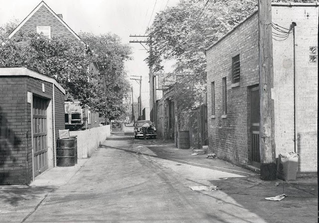
Despite their initial widespread adoption, cinder-paved alleys presented several drawbacks over time. The porous nature of cinders made them susceptible to erosion and dust generation, particularly during arid periods. Many children playing in these alleys ended up in hospital emergency rooms after scraping their knees and elbows on the rough surface. Today, no cinder alleys can be found in Chicago.
As Chicago's economy flourished and the demand for superior infrastructure intensified, the prevalence of cinder-paved alleys waned. Asphalt and concrete gained favor for alley paving due to their resilience, aesthetic appeal, and ease of maintenance.
By the mid-20th century, cinder-paved alleys had become a rarity in Chicago, gradually replaced by more durable and aesthetically pleasing alternatives.
Some heavily used alleys were paved with Belgian woodblocks. Before the Belgian blocks became common, many different pavement methods had wildly varying advantages and disadvantages. Because it was so cheap, woodblock was one of the favored early methods.
Chicago street paver bricks were also used, and then alleys were paved over with concrete or asphalt.
But private platting soon produced a few blocks without alleys, mostly in the Near North Side's early mansion district or in the haphazardly laid-out industrial workingmen's neighborhoods on the Near South Side.
However, alleys became the overwhelming norm in city planning as the National Land Survey imposed its grid framework upon Chicago's expanding street and block patterns. Together, they enabled the city to evolve a “system” of mass-produced services and mass-produced access, one of the civic accomplishments of the century.
By 1900, over 98% of the city's residential blocks had alleys; a century later, the proportion was still well over 90%.
 |
| A typical “Manure Vault” in a Chicago alley in 1918. |
Alleys were used by a variety of horse-cart peddlers selling everything from fresh fruit to knife sharpening. With so many peddlers throughout the city, horse manure was a huge problem. My article, "How the City Dealt with all the horse manure," explains how manure vaults were a big part of Chicago's alleys before the turn of the 20th century.
Early suburban developments showed a rising ambivalence toward alleys (Olmsted & Vaux's 1869 Riverside plat contains 31 blocks with alleys and 50 without them). Around World War I, 'modern' planning theory declared alleys wasteful and undesirable, and the last outer fringes of the city of Chicago, along with the vast majority of the suburban territory, were developed thereafter without alleys.
Alleys developed social meanings early on. In middle-class areas, the street represented the respectable front, while the alley saw the servants and suppliers do the dirty work. In working-class areas, alleys provided space for small manufacturing, repair shops, rear houses, children's play space, and, eventually, garages. Much of Chicago's elevated rapid transit system came to run along alleys.
Chicago's alley life, reflecting in many neighborhoods extreme low-rise urban congestion (in contrast to that of New York's tall tenement blocks), spurred intense social criticism by Century's end for the health and behavioral 'pathologies' it supported, but improvements came slowly. In the core areas, the impact of business district expansion, expressways, public housing projects, and large-scale urban renewal after World War II obliterated thousands of alleys. In the rest of the city and in some railroad suburbs, however, alleys have survived the new millennium largely intact and contribute hugely to the pulse of Chicago's daily life.
Compiled by Dr. Neil Gale, Ph.D.


