Saturday, December 3, 2016

The History of the Chicago Water Tower - One of Six Structures That Survived the Great Chicago Fire of 1871.

The Chicago Water Tower was completed in 1869 by architect William W. Boyington. It is 154 feet high and made from yellowing Joliet limestone. Inside was a 138-foot high standpipe, three feet in diameter, to balance the water flow.
In addition to firefighting, the pressure in the pipe was regulated to control water surges in the area. The foundation of the Water Tower consists of 168 piles filled with concrete and capped with 12-inch oak timbers. Massive stones in cement complete the base up to six feet below the grade. 
Looking northeast on Chicago Avenue at the Chicago Water Tower and Pumping Station in 1869.
The Water Tower rises in five sections from the square ground-level base with battlement pillars at each of its four corners. Each of the 40-foot-wide sides has a stately doorway and two grand windows. The second and third sections are similar in design as they rise in diminishing size.
Looking north on Pine Street (now Michigan Avenue) shortly after the Chicago Fire. 1871
The octagonal tower is centered and set back from the top of the third section, rising 154 feet above ground level. The standpipe was removed in 1911 when it was no longer needed. However, the spiral staircase that encircled the standpipe is still intact and used to reach the tower cupola. Together with the adjacent Chicago Avenue Pumping Station, it drew clean water from water cribs in Lake Michigan.
The Water Tower gained prominence after the Great Chicago Fire of 1871. While some incorrectly believe the tower was the only building to survive the fire, a few other buildings in the burnt district survived along with the tower. The Water Tower was the only public building in the burnt zone to survive and is one of just a few surviving structures still standing today.
Chicago Water Tower, 1890.
Looking south along Pine Street (now North Michigan Avenue) from Pearson, Chicago, 1892.
Since the great Chicago fire, the tower has become a symbol of old Chicago and the city's recovery from the conflagration of 1871. 
Water Tower and Pumping Station looking northwest from the corner of Pine Street (Now North Michigan Avenue) and Chicago Avenue, Circa 1890
In 1918, when Pine Street (now North Michigan Avenue) was widened, the plans were altered to give the Water Tower a featured location.
Looking North on Michigan Avenue, Chicago. 1926
Water Tower, Kaufman & Fabry, 1929
The intersection is at Michigan Avenue and Pearson Street, Chicago. 1940s
Double-decker Chicago Motor Coach Company bus in front of the Water Tower on Michigan Avenue, Chicago. 1941
The Water Tower has undergone two renovations. The first took place over three years, from 1913 through 1916. At that time, many of the limestone blocks were replaced. The second renovation occurred in 1978, mainly consisting of interior changes with only minor changes made to the exterior of the building.
Looking east at the Chicago Water Tower, circa 1975.
That's Water Tower Place - Shopping Center & Condominiums under construction.
The Water Tower is functionally obsolete and serves as a visitor information center where the public can obtain literature about Chicago attractions. The Tower is also home to City Gallery, Chicago's official photography gallery. 
The Chicago Water Tower was designated the first American Water Landmark in 1969 and a Chicago Landmark in 1971. Chicago Avenue Water Tower and Pumping Station were listed on the National Register of Historic Places as "Old Chicago Water Tower District" in 1975.

In 2014, Water Tower Park was renamed "Jane Byrne Park" to honor the 50th Mayor of Chicago (1979-1983) and the first female mayor of the City of Chicago. 


These six structures are the only structures from the burnt district to survive the fire:
  • St. Ignatius College Prep.
  • St. Michael's Church, Old Town, Chicago.
  • Chicago Water Tower.
  • Chicago Avenue Pumping Station.
  • Police Constable Bellinger's cottage at 2121 North Hudson, Chicago.
  • Ironically, O'Leary's House, located at 137 DeKoven Street, was spared from the fire.  O'Leary's Post Fire House Photographs.


Claims of Surviving Structures:
  • Old St. Patrick's Church was located at 121 Adams Street (700 West Adams Street, today) it was a survivor of the 1871 Chicago Fire because the church was not in the burnt district. The Church was a few blocks farther west than the fire reached.
  • St. James Cathedral at 65 East Huron Street, Chicago, was totally gutted when the Great Chicago Fire erupted. Nothing was left but the stone walls, the Civil War Memorial, and the bell tower, whose bells rang for as long as possible, warning the neighborhood of the encroaching fire.
NOTE: Addresses are before the City of Chicago's Renaming and Renumbering in 1909. Use the documents below to get today's street names and current address numbers.

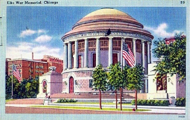
Elks National Veterans Memorial, Chicago, Illinois.

Elks National Veterans Memorial - 2750 North Lakeview Avenue, Chicago, at the intersection of Sheridan Road and Diversey Parkway in Chicago's Lincoln Park neighborhood.
The Elks Veterans Memorial is a tribute to the bravery, loyalty, and dedication of the thousands of Elks who have fought and died for our country. It has been described as one of the most magnificent war memorials in the world, but with its monumental architecture and priceless art, the Memorial is more a symbol of peace and of the patriotism of the members of the Elks fraternity.
Construction of the Elks Veterans Memorial began in 1923, after the Order unanimously agreed on a spacious site for the building, looking out over Chicago's Lincoln Park and within a stone's throw of Lake Michigan.
Workers laid the memorial's cornerstone on June 7, 1924, amid impressive ceremonies conducted by officers from the Grand Lodge.
Two years later, on July 14, 1926, the Annual Convention of the Order was held in Chicago and the building was officially dedicated to the memory of the more than one thousand Elks lost in World War I in front of a massive crowd of Elks and their families that stretched across the street and into the park.
A Chicago Landmark since October 1, 2003.
Compiled by Neil Gale, Ph.D.

A crowd of cyclists and spectators gathering for a bicycle race in front of the Chicago Water Tower. (1901)

A crowd of cyclists and spectators gathering for a bicycle race in front of the Chicago Water Tower. (1901)
-- Note the Ivy growing on the Water Tower. --

Champaign Automobile Company, 504 North Neil Street, Champaign, Illinois. (1908)

Champaign Automobile Company, 504 North Neil Street, Champaign, Illinois. Showing the west side of the structure. (1908)
This building is still standing. Listed at 514 North Neil Street, Champaign, Illinois.

Friday, December 2, 2016

The Green Tree Tavern and Inn, Lake and West Water Streets, Chicago, Illinois. A first hand account of an overnight stay.

The Green Tree Tavern was built the same year Chicago was incorporated as a town in 1833[1]. It was located at Wolf Point on the Northeast Corner of Lake and West Water Streets (Now Canal Street), Chicago, by Silas B. Cobb for James Kinzie (the second son born to John Kinzie and his first wife Margaret Mckenzie Kinzie) as a two-story frame building and opened by David Clock.

James Kinzie also lived and sold merchandise in part of the building. The Green Tree Tavern was an addition to the old Wolf's Point Tavern that was run at an early date by Elijah Wentworth. Later, Edward Parsons was the proprietor of the Green Tree Tavern. Renamed Stage House in 1835, then renamed to the Chicago Hotel a few years later. John Gray, of Grayland, Illinois, a beautiful Chicago suburb, was the landlord at the Chicago Hotel from 1838 to 1841. Still, later it was renamed the Lake Street House.
AN OVERNIGHT STAY AT THE GREEN TREE TAVERN & INN
At the Green Tree, we were spared the ceremony of registering because they had no book for that purpose. Nor was it certain that we could find accommodation until our host had returned from the kitchen, whether he had gone to consult with his efficient wife, who performed the never-ending duties of housekeeper, landlady, meat and pastry cook, scullion (a
 servant assigned the most menial kitchen tasks)
, chambermaid, waitress, advisor, and personal attendant upon all the ladies and children who took shelter under the Green Tree; while her liege lord filled the many positions of Boniface, clerk, bartender, butler, steward, walking encyclopedia, and general roustabout.

The momentous council was at length ended and we were assigned a room adjoining the one we had first entered, which was the bar, reading, smoking, and reception room, ladies parlor, and general utility place, in one. Our room was about 12x12 feet with two 6x8 foot windows, two doors, two beds, two red pictures, two chairs, a carpet worn in two, and was altogether too dirty for the comfort of persons unaccustomed to such surroundings. Placing our hand luggage and two trunks inside, we returned to the family room and public rendezvous and took observations.

On the east and west sides of the seemingly prehistoric whitewashed walls and board partitions were the inevitable puncheon benches. Scattered around in a more informal manner was an assortment of wooden chairs. Near the north end was a bar counter useful not only to receive the drinks but umbrellas, overcoats, whips, and parcels. The west end of the bar was adorned with a large inkstand placed in a cigar box filled with No. 8 shot, in which were sticking two quill pens — steel being unknown here, though invented in 1830. This end of the counter afforded the only opportunity in the establishment for a young man to write to the girl he left behind, standing up to his work like a prizefighter with a host of backers and seconds around him to see that he had fair play. Near the inkstand were several tattered newspapers, the latest giving an account of a great snowstorm in Boston. At the other end of the counter were a dozen or more short pieces of tallow candles, each placed in a hole bored in a 2x4 block fortified by sixpenny nails, standing like mourners around the circular graves in which they had seen so many flickering lights pass away into utter darkness.
Hanging in a row against the wall were large cloth and leather slippers, which the guests were expected to put on at night, that mud might not be tracked to every part of the house. Under the counter were a large wooden boot jack and a box containing two old-fashioned boot brushes and several pieces of hard, raw tallow, black from the application to boots. There was also a collection of old-fashioned, perforated tin lanterns. Though not equal to their glass descendants, they were a great improvement on the lanthorns [2] of ye olden times, and certainly very useful in enabling one to distinguish the difference between the necessary stepping-blocks in the streets and the altogether unnecessary mud puddles. 

There was also to be seen the indispensable tinder box, used fifty times a day, at least, for lighting pipes, when the old, rusty, bar stove was taking its summer vacation. Above the tinder box was one of the old-fashioned, square, cherry, veneered Connecticut clocks. On the glass door beneath the dial plate was a purple horse drawing a blue plow, which a man with a green coat and yellow trousers was guiding. The men of the Nutmeg State were giants in those days, judging by this specimen, who was taller than the apple tree in the corner, which, in turn, was loaded with fruit larger than the man's head. Beneath the tree was a monstrous bullfrog, considerably larger than the crimson calf beside it. The ablutionary arrangements were exceedingly primitive, consisting of tin washbasins, soiled towels, small mirrors, and toothless combs. Several dishes of soft soap were arranged along the back of the water trough. Though pretty strong for washing the hands of a "Tenderfoot," it was in great demand after greasing boots or applying tar to wagon axles.

In the middle of the room, standing in a low box filled with lake sand, was a large stove used in winter to good advantage not only for the warmth imparted to the room but for furnishing hot water for toddies, shaving, and washing as well. On the right side of the door going into our room was a Cook County License, costing $5, which permitted the recipient to keep an inn and tavern.

The license contained printed regulations as to prices:
For each ½ Pint; Rum, Wine, or Brandy - 25¢ 
For each Pint; Rum, Wine, or Brandy - 37½¢ 
For each ½ Pint Gin - 18¾¢ 
For each Pint Gin - 31¼¢ 
For each Glass of Whiskey - 06¼¢ 
For each ½ Pint Whiskey - 12½¢ 
For Cider or Beer: 1 Pint - .06¼¢; 1 Quart - 12½¢
For Breakfast and Supper - 25¢ 
For Dinner - 37½¢ 
For Horse single feed - 25¢ 
By the time we had read our fate in the license figures, we were called to supper by a large bell, which was run by our host in a manner that required no explanation as to its meaning. In the dining room were two tables, the length of the room, covered with green checked oilcloth, loaded with roasted wild ducks, fricassee of prairie chickens, wild pigeon pot pie, tea, and coffee, creamless, but sweetened with granulated maple sugar procured from our red brethren. These furnished a banquet that rendered us oblivious to chipped dishes, flies buzzing or tangled in the butter, creeping beetles, and the music of the Mosquito Band. We paid no attention to pewter spoons and pewter castors containing such condiments as mustard in an uncovered pot and black pepper coarsely crushed by the good housewife, or to cruets with broken stoppers filled with vinegar and pepper sauce. Our appetites put to flight fastidiousness and, even though the case knives and forks had never been scoured, we took it for granted that they were washed after every meal and we paid strict attention to our own business, and soon after tea retired.
Written by Edwin O. Gale in 1835.

GREEN TREE TAVERN SURVIVES THE
GREAT CHICAGO FIRE OF 1871
The Green Tree Tavern survived the Great Chicago Fire because it was on the west side of the Chicago River. The conflagration consumed the east side of the north and south branches, jumping the river from the south to the north. See Burnt District Map.
Green Tree Tavern on Milwaukee Avenue,
between Fulton and Lake Streets, Chicago circa 1880s
In 1880 the Green Tree Tavern was loaded on rollers and moved away from its historic stand at the northeast corner of Canal and Lake streets and dumped down on the new, unhistorical thoroughfare called Milwaukee avenue.

It was given the address of 33-35-37 N. Milwaukee Avenue, which today is at the 200 block of North Milwaukee Avenue, between Fulton and Lake Streets.

The structure was in poor shape before the move. Impertinent trade had sheared off the corners, leaving only a disjointed wreck of a building, with a quivering chimney atop. 

A tottering, paralytic old wreck, sway-backed, with the windows all askew and the clapboards rattling in the cool night winds. It was demolished by 1903.


Compiled by Dr. Neil Gale, Ph.D.


[1] The first plat of the town of Chicago was filed in 1830. Chicago was incorporated as a town on August 12, 1833, with a population of about 350. With a population of 4,170, the town of Chicago filed new Incorporation documents on March 4, 1837, to become the City of Chicago and for several decades was the world's fastest-growing city.

[2] Lanthorn is an old British word that is defined as a lantern. 

The 2900 South Michigan Avenue Block, Chicago. (circa. 1890)

The 2900 South Michigan Avenue Block, Chicago. (circa. 1890)

The Mammoth Spring Ice House, Fullersburg, Illinois. (1880-1910)

The Mammoth Spring Ice House was built in 1880 by John F. Ruchty, owner of the Mammoth Spring Ice Company, on Salt Creek at the foot of Washington Street in Fullersburg, Illinois. Now a part of Oak Brook, Illinois.
The Mammoth Spring Ice House, Fullersburg, Illinois
The Mammoth Spring Ice House building was 100 feet long, 50 feet wide and 30 feet high, with double walls 18 inches thick filled with sawdust. The ice was packed in tiers, each layer covered with wood shavings. Fifty to sixty men were required to fill the ice house. 

When the ice reached the thickness of twelve to eighteen inches in the creek, a field was marked out, cut in blocks 24 inches square and floated on rafts through channels to the water box. Then the ice was hauled up a chute by means of a jack attached to a long rope through a series of pulleys. Two teams of horses furnished the power. 

Several thousand tons of ice was stored each winter for delivery the following summer at 50¢ per one-hundred pounds. Five wagons made daily trips supplying ice to markets and homes in LaGrange, Western Springs, Hinsdale and South Elmhurst. In 1885, the increasing demands for ice resulted in construction of an additional ice house and two more wagons to serve the area.

When artificial ice (from refrigeration cooling systemsreplaced natural ice, the Ruchty Brothers sold their business in 1910 to the West Suburban Ice Company. A few timbers lining the bank of Salt Creek are all that remains of the ice house. 

Compiled by Neil Gale, Ph.D.

The story of Frink, Walker & Co., Stage Line, northern Illinois' transportation monopoly of the 1800s.

What the railroad station was to rural country towns, Frink, Walker & Co., was to early Chicago. It was the center of public interest. Several times a day strangers arrived in town, residents set out upon long and often hazardous journeys, mail was received and dispatched and it was the transportation center of the growing town.

A man named John Frink set up the first successful stage line out of Chicago in 1832 with partner Charles K. Bingham. The first Frink, Bingham & Co. Stagecoach ventured west out of Chicago to Fullersburg [1] (Oak Brook), 15 miles from Chicago, which followed the Indian Boundary Line (Indian Boundary Park, Chicago so named because the park is on the Indian boundary).
Frink joined forces with Martin O. Walker and Walker's brother, Curan (a silent partner) on June 1, 1840. Frink provided the political, operational and sales know-how, while Martin provided business experience and funding along with Curan.
The new line was known as the Frink, Walker & Co., and their coaches started from a shanty-like building located in the heart of Chicago at the corner of Lake and Clark Streets. By 1835, Frink moved two doors west, on the south side of Lake Street, off the corner of Lake and Dearborn streets.
Frink, Walker & Co., General Stage Office, two doors west, on the south side of Lake Street, off the corner of Lake and Dearborn streets, Chicago, Illinois. (1844)
From 1832 until the construction of the first railroad in 1848, the stagecoaches of Frink, Walker & Co., were the largest company connecting Chicago with the outside world. For several years after the primitive locomotives had come puffing in and out of town, the stages continued to run regularly, carrying passengers and mail to and from many places not reached by the first railroads. 
Frink, Walker & Co., General Stage Office.
Even before Chicago was incorporated as a town in 1833, the firm established a stagecoach line to Galena in 1832. Oddly enough, that town was also the terminus of the first railroad.

The Galena-Chicago route had many stops; at Lena, Illinois, going east, the stage route followed today's US 20 through Eleroy, Freeport, Rockford, Belvidere, Bloomingdale and other towns along the way. 

The stages typically left the Frink, Walker & Co., Chicago depot between 4 and 6 am to take advantage of as much daylight as possible. They stopped for the night at inns along the route. The 150 to 160 mile trip, depending on the route, took the better part of five days but that was cut to two days when they ran around the clock, with stops every 12 to 15 miles at relay stations to change horses. The fare was $12.50 ($315.00 today). Passengers were often forced to help push the coaches out of the mud or help with repairs. Accidents were common, as were injured horses that often immobilized the stages and forced passengers to continue their trips on the first farm wagon that came along.

Even meals could be an ordeal. The inns usually didn't start cooking until the coach arrived. That took about 50 minutes, so the passengers had to wolf down lunch or dinner in just 10 minutes to avoid being left behind after the hour layover.

A few years later, the 97-mile trip from Chicago to Milwaukee by stage consumed two days, with an overnight stop in Kenosha, but competition from Great Lakes ships had reduced the summertime fare to $3 ($70 today).
Frink, Walker & Co., Offices, 1845.
The first non-local stagecoach line arrived from Detroit in 1833 after the Black Hawk War of 1832 ended an Indian revolt over ownership of Illinois farmland and made land travel safe west of Chicago.

In 1834, Dr. John T. Temple started a stage line from Chicago southwest to Peoria to meet the steamboats plodding up and down the Illinois River from St. Louis. (The 96-mile Illinois and Michigan Canal that would eventually connect Chicago with the Illinois River at Ottawa was not completed until 1848.) Frink, a Connecticut native who learned the stagecoach business in the East, formed a rival stage-steamboat line in 1834, then in 1837, he bought out Temple.

The mail in the 1830s and '40s traveled on Frink, Walker & Co. coaches that rattled and bounced over Potawatomi trails to Detroit, Peoria and Galena at an average of fewer than 10 miles per hour dodging tree stumps and fording streams.

Frink fought all the other stage lines, in true Chicago style, eventually emerging in control of the stages in and out of Chicago. 

The Chicago-Rockford route began sometime around 1837. In 1848 the schedule from Chicago to Rockford was 24 hours. The coaches were always drawn by four horses and the horses were changed at intervals of 15 miles at stations built for that purpose. Coaches left the main office in Chicago on Sunday, Tuesday, and Thursday and returned on the alternate days. The fare was $5.00 ($175 today).

As settlements increased in number, Frink, Walker & Co., met the growing demands by establishing new stagecoach lines to all parts of the Northwest, as far as Milwaukee and Prairie du Chien Wisconsin, and to the south, a line extended to St. Louis Missouri. Many a lady passenger became hysterical in the Stagecoach when the driver seemingly headed for the middle of Lake Michigan while fording the more shallow water in the delta to the Calumet River, in the days before bridges.
The Stagecoach wasn't as glamorous as the movies made them out to be.
The stagecoach office, from which all the coaches departed, and which was usually surrounded by an interested group of idlers [2]. Many of the stages, especially those obliged to traverse muddy roads, were equipped with six horses, and, in addition to the skillful driver, carried a postillion [3], who blew a horn gaily when the stage was pulling out, and played a fanfare on its arrival to notify the idlers that the stage was in with the mail and passengers. 

Now and again the passengers and drivers on these coaches had a brush with the Indians on lonely stretches of the road, but more often their experiences were confined to struggles with the deep mud of the roads through the woods and across the prairies. The extension of the railroad lines to all parts of the territory reached by the stages led to the abandonment of a picturesque feature of life in early Chicago.

Frink sold the stagecoach business to Walker sometime in the 1840s, then began investing in iron horses.

Frink died of a stroke in 1858 at age 63; Walker operated stagecoaches for another 30 years in more remote areas of the Midwest not served by railroads.

Compiled by Dr. Neil Gale, Ph.D.


[1] Fullersburg, Illinois was on the edge of Indian Country. It was where a roadhouse once stood along the Southwest Plank Road (now Route 34 / Ogden Avenue), a stop on the Frink, Walker & Co. Known as Castle Inn, it is believed that Abraham Lincoln spoke from their veranda while riding his circuit. 

Lincoln's circuit extended thru 18 counties and that he went from Clinton to Monticello, then to Urbana, Danville, Paris, Charleston, Shelbyville, Sullivan, Decatur, Taylorville, and Springfield. At different times in the course of Lincoln's circuit-riding, he traveled thru each of the following counties: Sangamon, Menard, Mason, Tazewell, Woodford, Livingston, McLean, DeWitt, Piatt, Champaign, Vermilion, Edgar, Coles, Shelby, Moultrie, Macon, and Christian.


[2] Idler; A habitually lazy person.


[3] Postillion; A person who rides the leading left-hand horse of a pair or team drawing a coach or carriage, especially when there is no coachman.

Chicago's Famous Block 37.

The story of Chicago's Block 37 is the history of a great American city's downtown business districts in a microcosm. Block 37 is bordered by State, Randolph, Dearborn and Washington streets.
Block 37 - Randolph Street, Chicago, Illinois. 1909
At the center of Chicago, this typical urban block missed no trend, from the first office buildings in the 1870s to the early skyscrapers of the 1890s and the supermarkets of the 1930s. Even through long decades of decline, from the perceived street anarchy of the 1960s to the massive urban renewal of the 1980s that finally demolished the block, Block 37 has mirrored the enthusiasms and fears of the City. The movie palaces, seedy political hangouts, fine billiard parlor, novelty store, and gourmet food hall made it a primary destination for those seeking the Loop's pleasures. Also, a place of work where small newspapers were published, violins repaired, hair cut, and fortunes read, this one city block, in its prime, attracted thousands of people an hour. On a typical day, it housed the population of a small town, only to be completely empty at night. 

All the City's variety was packed into 16 buildings of various sizes and conditions. Its landlords, high and low, were among Chicago's first families and fabled entrepreneurs. A scene for brilliant acts of charity and extraordinary moments of predation. Block 37 was a prime arena for the urban arts, from fly-by-night retailing and three-card monte to international real-estate deals involving hundreds of millions of dollars. To understand the rise and fall of this one block in some of its daunting details is to appreciate Chicago's unique attraction to city lovers and haters alike. To know Block 37 is to know Chicago.

Favored by its unique geography, the land was to become Block 37 already had a rich history before the first Europeans couldoed into the swampy prairie on Lake Michigan. At least 100 years before Chicago (Chicagou or Chicagoua) was surveyed, scribed, and squared, the Potawatomi pursued an active commercial life on the site. With its proximity to the lake and the main branch of the Chicago River, the block was important, too, after Fort Dearborn was established, and the area became a key area of settlement of the Northwest Territories.

The block was platted in James R. Thompson's 1830 survey and numbered one of the City's original 58 blocks. Its strategic location between State and Dearborn Streets to the east and west and Randolph and Washington to the north and south assured that the block's original eight lots, equally cut from only 120,000 square feet of ground, would become fully deployed in the City's remarkable political, commercial, and industrial development.
James R. Thompson's 1830 plat survey.


After Chicago's incorporation as a town in 1833, Block 37, situated only several hundred yards from the Cook County courthouse and across the street from the City's largest bank, boomed along with the City. The famous Crosby Opera House was built between State and Dearborn Streets on Washington Street.

When the Great Chicago Fire of October 8, 1871, razed the entire downtown, the block had already been densely developed for decades. Rebuilt immediately after the fire at over four times its original square footage and increasingly added to over the next century, Block 37 shared the fortunes of other American downtowns from New York to San Francisco. Resiliently prosperous and endlessly inventive in the sort of commerce it could support, the block survived not only the fire but a worldwide Depression and a host of cunning mayors and deal-makers until it finally fell prey in 1989 to the final "improvement" that flattened, in the name of urban renewal, every one of its buildings—including, without distinction, its architectural treasures and notorious firetraps.

Block 37 was, in the end, a victim of the trends it had so efficiently exploited in the past. After World War II, as Chicago's population began its permanent migration away from the core and out to the suburbs, the block started to suffer from the neglect that would eventually make it a candidate for urban renewal. Beginning in the early 1960s, the historic Loop was bypassed to redevelop North Michigan Avenue. The old downtown was perceived and relentlessly advertised as hopelessly decayed and dangerous. 

The once superior location of Block 37 at the matrix of the City's political, commercial, and social life now doomed it. By the 1970s, State Street had lost its preeminence as a shopping center to the department stores on Michigan Avenue and the large regional malls multiplying in the suburbs. The entertainment "Rialto" along Randolph Street — Chicago's equivalent to Times Square — had closed its live shows and subsisted on pornography and action films. At the same time, on Washington Street, the gourmet shop Stop and Shop, a city institution, went out of business. Offices for lawyers, political activists, and skilled artisans on the block's Dearborn Street side went unrented as the center of Chicago shifted to the grand new towers of the West Loop. None of the billions of dollars flooding the City during the skyscraper boom of the 1980s reached Block 37 in time.

Ironically, the block's very dereliction became its last chance. Speculators and city hall insiders had written down the land values of the entire North Loop to the point in 1979 when the Chicago Plan Commission declared 26.74 acres, seven full or partial blocks including Block 37, "blighted." This designation qualified the area for a "taking." Once, a valuable commercial property was seized from its lawful owners, condemned, and written down as worthless. After speculators had delayed the taking almost a decade and bid up land costs, the City paid nearly $250 million for the entire North Loop, including almost $40 million for Block 37 alone. In 1983, a local development group, JMB, won the right to develop the whole block. 

A series of delays, beginning with a challenge from historic preservationists and prolonged by costly legal battles, put off the block's demolition until 1989, when t
he City started to leveling Block 37 in 1989, making way for the construction of a mixed-use development that included office space, retail stores, and restaurants. Shoppers Corner was in the last demolition phase, closing in June 1991.

Chicago traded the land title to the developers for $12.5 million, less than a third of what it had paid. Plans to build two towers and a large retail mall fell prey to the national real-estate crash of the 1990s.
The Block 37 building at State and Washington Streets in Chicago's Loop.
The block was temporarily used as a winter skating rink and a summer student art gallery for almost a decade. At the opening of the twenty-first century, this once diverse and active place still lies empty, an unwanted orphan of progress. The history of Block 37 will continue to mirror the rise and fall of Chicago's downtown. Its long and varied history is an intimate calibration of the history of a great American city.

Compiled by Dr. Neil Gale, Ph.D. 

Looking North on Clark Street and Lincoln Park West, Chicago, Illinois. 1899

Looking North on Clark Street and Lincoln Park West, Chicago, Illinois. 1899

Thursday, December 1, 2016

Fort de Crévecoeur and Fort Pimiteoui in the Illinois Country.

On January 5, 1680, eight canoes passed through the Narrows of the Illinois River above Peoria and came upon the Peoria Indians camped on both sides of the Pimiteoui Lake. With René-Robert Cavelier, Sieur de La Salle (Sieur de La Salle being a title only)  canoe on the right and Henri de Tonti on the left, eight canoes in total formed a line to cover the width of the river, signaling the Indians that they came in peace. The Indians were frightened at first, but, upon realizing that the white men meant no harm, welcomed them with a feast of bear meat, buffalo fat, and porridge. 
Antique French map of North America in 1681 by Claude Bernou, showing Fort de Crevecoeur location. Click for a jumbo sized map.
Fort Crevecoeur (broken-heart) was the first public building erected by white men within the boundaries of the modern state of Illinois and the first fort built in the West by the French. It was founded on the east bank of the Illinois River, in the Illinois Country near the present site of Creve Coeur, a suburb of Peoria, Illinois, in January 1680. It was destroyed on April 16th of that same year by members of La Salle's expedition, who were fearful of being attacked by the Iroquois as the Beaver Wars extended into the area.
Fort de Crévecoeur
La Salle paid the Indians for the corn taken from their village by what is now Starved Rock, Illinois, presented the chiefs with gifts of axes and tobacco, and smoked the calumet pipe. The Indians rubbed the bare feet of the priests with bear's grease to stimulate their fatigued muscles.
Map of Fort de Crévecoeur in 1680
That night, the Peoria Indians were visited by Monsoela, chief of the Maskouten nation, who, accompanied by a party of Miami Indians and their enemies, the Iroquois. Frightened by the sudden change in attitude on the part of the Peoria Indians, six of La Salles' men deserted the camp the following day.

Fort de Crévecoeur
This fort is known variously as Fort Saint Louis II, Fort Saint Louis du Pimiteoui, Fort Pimiteoui, and Old Fort Peoria (Pimiteoui, was the name of what is today's Peoria Lake).

On April 15, 1680, Tonti left Fort Crévecoeur with Father Ribourde and two other men to begin fortification of what is today called Starved Rock; Fort Saint Louis du Rocher. The following day, the remaining seven men at Fort Crévecoeur pillaged the fort of all ammunition and provisions, set it ablaze destroying it, and fled back to Canada.

In order to reassure the Indians, La Salle agreed to help defend them against the Iroquois. The Illinois River had frozen over during the night, but as soon as the river began to thaw, LaSalle and his men began the building of Fort Crévecoeur one league downstream and across the river from the Pimiteoui Village.

According to La Salles' journals, translated by Pierre Margry;
"On January 15, toward evening a great thaw, which opportunely occurred, rendered the river free from ice from Pimiteoui as far as there (the place destined for the fort). It was a little hillock about 540 feet from the bank of the river; up to the foot of the hillock the river expanded every time that there fell a heavy rain.
Two wide and deep ravines shut in two other sides and one-half of the fourth, which I caused to be closed completely by a ditch joining the two ravines. I caused the outer edge of the ravines to be bordered with good chevaux-de-frise (a series of heavy timbers placed in a line, interlaced with other diagonal timbers which were often tipped w/ iron spikes), the slopes of the hillock to be cut down all around, and with the earth thus excavated I caused to be built on the top of a parapet capable of covering a man, the whole covered from the foot of the hillock to the top of the parapet with long madriers (beams), the lower ends of which were in the groove between great pieces of wood which extended all around the foot of the elevation; and I caused the top of these madriers to be fastened by other long cross-beams held in place by mortise and tenon with other pieces of wood that projected through the parapet.
In front of this work I caused to be planted, everywhere, some pointed stakes twenty-five feet in height, one foot in diameter, driven three feet in the ground, pegged to the cross-beams that fastened the top of the madriers and provided with a fraise at the top 2½ feet long to prevent surprise. I did not change the shape of this plateau which, though irregular, was sufficiently well flanked against the savages[1]. I caused two lodgments[2] to be built for my men in two of the flanking angles in order that they be ready in case of attack; the middle was made of large pieces of musket-proof timber; in the third angle the forge, made of the same material, was placed along the curtain which faced the wood. The lodging of the recollects was in the fourth angle, and I had my tent and that of the sieur de[3] Tonti stationed in the center of the place."
Fort St Louis du Pimiteoui 
Reestablishing a more lasting presence, Fort St Louis du Pimiteoui was established nearby in 1691, a center of trade during the colonial period. Henri de Tonti was a primary founder of both the Crevecoeur and Pimiteoui posts.
Fort Pimiteoui (Old Peoria) circa 1702
Two of the men who had been at the fort joined Tonti at Starved Rock and told him of the fort's destruction. Tonti sent messengers to La Salle in Canada to tell him what had happened and returned to Fort Crévecoeur to collect those tools that had not been destroyed and take them to the Kaskaskia Village at Starved Rock.

On the tenth of September 1680, six hundred Iroquois warriors, armed with guns, came upon the Kaskaskia village. Both the Iroquois and the Illinois Indians accused Tonti of treachery. He tried to mediate their differences and detain the Iroquois until the old people, women, and children could flee the village. Tonti was wounded by an Iroquois who stabbed him with a knife. The Kaskaskia village was burned and the Iroquois built a fort on the site. Tonti, with his companions, fled for Green Bay.

ADDITIONAL READING:
Fort Crévecoeur By Arthur Lagron, Civil Engineer and Ex-Officer of the French Genie Militaire. (This article was published in the early 1900s and in a Historical Journal housed at the Peoria Library. Transcribed by Kim Torp) 

Compiled by Neil Gale, Ph.D.


[1] "SAVAGE" is a word defined in U.S. dictionaries as a Noun, Verb, Adjective, and Adverb. Definitions include:
  • a person belonging to a primitive society
  • malicious, lacking complex or advanced culture
  • a brutal person
  • a rude, boorish or unmannerly person
  • to attack or treat brutally
  • lacking the restraints normal to civilized human beings
Unlink the term "RED MEN," dictionaries like Merriam-Webster define this term, its one-and-only definition, as a Noun meaning: AMERICAN INDIAN (historically dated, offensive today).

The term Red Men is used often in historical books, biographies, letters, and articles written in the 18th, 19th and early 20th centuries.

I change this derogatory term to "INDIANS" to keep with the terminology of the time period I'm writing about.

[2] Lodgments: A place in which a person or thing is located, deposited, or lodged.

[3] Sieur de: {French}; French nobility.