Thursday, August 30, 2018

Fort Nonsense, Will County, Joliet, Illinois (1832)

While the Black Hawk war was raging in 1832, the few settlers who remained to keep their homestead claims, built a fort in the present city limits of Joliet, which they called "Fort Nonsense." The fort was labeled “Fort Nonsense” because it was constructed without provision for obtaining basic necessities such as food, fuel, and fresh water.

The fort was built on the homestead of Mr. Jesse Cook, which stood on a bluff overlooking the west side of the Desplaines River in today's Joliet, near the current site of St. Peter’s Lutheran Church and School at 310 N. Broadway Street. The fort was near the “old settler’s cave,” used for protection against Indians in the early settlement of the area.
The fort was of the stockade order, approximately 100 square feet in size, with a blockhouse at the northeast corner and fenced in upright logs (vertically) set in the ground, and about eighteen feet high.
"The hill was the shape of a round knob; difficult to ascent in those days. The bluff at the right was broken and abrupt, and a silvery cascade during some seasons of the year, with a cedar lined dell, formed a picturesque background. The fort was of the stockade order, with a blockhouse at the northeast corner, projecting beyond the stockade, with portholes for downward as well as "straight-out" shooting. This was built by a part of the regiment which was sent to the relief of the settlers from Danville, through the efforts of Gurdon S. Hubbard, who was there at the time." (unknown author)

The fort was torn down soon after it was built, but ironically, the blockhouse of Fort Nonsense was used as one of Joliet’s first schoolhouses. The first school was taught in Mr. Reeds cabin in the winter of 1832. For the 1833 school year, Miss Persis Cleveland taught school in the Fort Nonsense blockhouse.

Compiled by Neil Gale, Ph.D. 

Monday, August 27, 2018

Fort Piggott, Piggott's Ferry and a brief history of James Piggott.

ABOUT JAMES PIGGOTT
James Piggott took the long view regarding the development of Illinois territory. Born in Connecticut, his fortunes took him further west throughout his life. He served in the Revolutionary War as a member of the Eighth Pennsylvania Regiment. After his military service he joined George Rogers Clark recruiting families to live in the proposed town of Clarksville, close to present day Wickliffe, Kentucky. Chickasaw Indians forced the abandonment of this endeavor in 1782. 

Piggott and family settled in Columbia, Illinois, in 1783. During that time, the area was swampy and uninhabited. To get to St. Louis from the Illinois side, you'd have to start from Cahokia and go North, up the Mississippi, against the current, to get to St. Louis. Piggott had a brilliant idea. He laid a planked road from Columbia to a low point on Cahokia Creek. Then he built a 150-foot wood bridge over the creek so goods could get to his ferry landing. 

Piggott and seventeen families built cabins and a blockhouse just west of modern day Columbia. 

FORT PIGGOTT (1783-c.1791)
Fort Piggott, or as it was sometimes called; Fort Big Run. (It was Piggott’s wish to change the name of the town to “Big Run.”) James Piggott erected this fort in 1783 at the foot of the bluff, one and one half miles west of Columbia.
A drawing of Fort Boonesboroug, Kentucky - Fort Piggott was yet another look-a-like. 
The fort was located on what was known as Carr Creek, which the French called "Grand Risseau" (literal translation: large gully). The creek was named for Lenard Carr, an early settler.

James Piggott fought with George Washington in the Battle of the Brandywine. As Indian depredations increased, the Fort became a safe-haven for the settlers. When word went out to summon the settlers to the fort it was said that even the children realized the danger. In 1783 there were forty six inhabitants living at Fort Piggott. Indian killings accelerated during 1789 and 1790; no one was safe. Indeed, one-tenth of the population was killed by the Indians.

Assenath Piggott, James Piggott's daughter, was born on January 17, 1791 within Fort Piggott, St. Clair County, Illinois.

PIGGOTT'S FERRY
The growth of St. Louis encouraged the development of the Illinois side of the Mississippi River. Demand to ferry to St. Louis increased. In 1795 Piggott opened a ferry service which quickly became a central point for travelers and goods. The ferry transported people, animals, carts, wagons, and goods directly to the St. Louis docks. The area around the dock, developed very quickly. Piggott faced competition from other entrepreneurs interested in capturing some of the ferry business.

Illinois Territorial Governor, Arthur St. Clair, made Piggott a Territorial Judge in 1790.
The location of Piggott's Ferry complex in 1795.
After James Piggott died in 1799, the ferry continued operation by his sons. The McKnight-Brady operation invested in Piggott's ferry. Eventually was sold to the Wiggins Ferry monopoly. They platted the land behind the Piggott ferry in 1818 and named it Illinoistown.

Compiled by Neil Gale, Ph.D. 

Thursday, August 23, 2018

Looking Northeast at the intersection of 107th and Halsted at an 1840s sod house in Chicago.

This photograph, shot sometime in the 1920s by a Daily News photographer, was known as a sod house.[1] More common than you might think, this house was probably built while homesteading in 1840s Chicago. Many families lived like this in the new frontier of the 1800s.

Compiled by Neil Gale, Ph.D.


[1] The sod house or "soddy" was a successor to the log cabin during frontier settlement of the United States. The prairie lacked standard building materials such as wood or stone; however, sod from thickly-rooted prairie grass was abundant. Prairie grass had a much thicker, tougher root structure than modern landscaping grass. Construction of a sod house involved cutting patches of sod in rectangles, often 2'×1'×6" and piling them into walls. Builders employed a variety of roofing methods. Sod houses accommodate normal doors and windows. The resulting structure was a well-insulated but damp dwelling that was very inexpensive. Sod houses required frequent maintenance and were vulnerable to rain damage. Stucco or wood panels often protected the outer walls. Canvas or plaster often lined the interior walls.

The Eleven Mile House Tavern at 92nd and State Streets in Chicago, 1879.

The Eleven Mile House Tavern was built in 1838 at 92nd and State Streets in Chicago. Photographed in 1879.

Riverview (Amusement) Park, Aurora, Illinois (1899-1910) - Fox River Park, Aurora, Illinois (1910-1925)

According to legend, Aurora's Senator Henry Evans wanted to build an interurban line from Aurora to Morris and connect with his friend's line, Senator McKinley's Illinois Traction System. Senator Evans was the man who had organized the Aurora City Railway Company in 1882 and began streetcar service with mule-drawn cars which were quickly converted to electric cars beginning in 1890. During the 1890's, he also built many buildings in Aurora. 

By the mid-1890's, streetcar lines in Aurora and Elgin were flourishing. Sections of interurban lines were being built to connect the two cities. There were rumors of a major interurban line to be built from Aurora to Chicago which would in later years become the Chicago Aurora & Elgin Railroad. By the late 1890's, "interurban fever" was gripping the Midwest, and during April of 1897, Senator Evans incorporated his line to run south from Aurora - the Aurora, Yorkville & Morris Railway Co. 

Within three months Senator Evans had secured the necessary franchises to run in and along the roads as far south as Montgomery and was buying land to continue south. However, there was "a hitch" in his plans. The best route from Montgomery to Oswego was through a particular farmer's field, and that farmer did not want to sell a narrow strip for a railroad to cut through the middle of his farm. After haggling with the farmer and threatening condemnation and lawsuits for nearly two years, Senator Evans finally gave up trying to buy just the narrow right of way and bought the whole farm! 

The next question was what to do with the land. It had open areas which could be turned into ball diamonds and campgrounds. The farm had a nice stand of trees along the Fox River and a bubbling clear water spring. The Fox River ran clearly and slowly by the banks and there was an island not too far off shore. What an ideal location for a park - Riverview Park! 

Construction began during the summer of 1899 on both the park and the interurban line running south out of Aurora. Senator Evans didn't order any cars for his new company, but he contracted for service with his Aurora Street Railway Co. 
The Riverview Park depot had room for several cars to load and unload passengers all at once. Here, car 103, a double-truck 12-bench open car built by the J. G. Brill Company in 1897, waits for returning passengers after a day of fun at the park.
The cars begin arriving at the raised platform depot at Riverview Park in this photo from 1900.
Rather than wait until the following spring, Riverview Park was opened when streetcars left Aurora to run as far south as the park. The day was Tuesday, November 7, 1899, and the first cars were operating at 1:00 p.m. Montgomery was decorated with flags and the people were out to welcome the first train. Four cars were running in each direction by 2:00 p.m. when about 500 people were present for the dedication of Riverview Park.


The transfer is almost complete as the streetcars are lined up on north Broadway in front of the CB&Q's roundhouse and shops waiting for the "go ahead" signal for the short trip to the park.
Senator Evans was disappointed that the brass band which had been hired for the occasion didn't show up, but - as the Aurora Daily Beacon story put it - "there was plenty of music in the air when the oratory was on." In a short talk, Mayor Howard said, "This beautiful spot is to be a prohibition park, and if anyone drinks liquor here, he will have to bring it in his clothes. It will be a credit to Aurora and Montgomery," he added. More addresses followed and later in the day, Goddard's string band furnished music for dancing. 
The midway was alive with people in this photo from about 1908. The 1907 consolidation and refurbishing had been completed and a new front had been added to the dance hall in the center, background. The entrances to the Figure 8 and Roller Coaster and other midway activities were behind the lighted facades to the right.
Riverview Park soon closed for the winter months, but it reopened with a gala grand opening in the early spring of 1900. The Aurora Daily News ran the banner headline: Great Crowds Take a Sunday Ride Down to Riverview Park to Attend the Formal Opening. "The weather was ideal and many people went on an outing. The first excursion cars were loaded and a general rush was made for the park. The electric car line was taxed to its utmost as three cars each way were kept busy until night with nearly every trip loaded to the guards - the record running over two thousand passengers. Carriages lined the roads and everyone enjoyed a happy time. The park did not look its prettiest because the trees had not yet leaved and the bare limbs shocked some of the more fastidious visitors; Senator Evans promised to have them clothed in a few weeks. A string orchestra furnished the music, Professor Greenough walked the tight rope and Amateur Banker made the grand balloon ascension and parachute drop in quite a professional manner.”

By early summer of 1900, the Aurora & Geneva Railway completed the final segment in the line from Elgin to Aurora, opening up more opportunities for direct streetcar connections to Riverview Park. A month later the Aurora, Yorkville & Morris R y. reached Oswego and by December had completed its line to Yorkville. This tapped a rural population that would ride the Interurbans to Riverview Park for picnics, boating, Chautauquas and other amusements. 

There were many special outings at the park each summer. According to the Aurora Daily News, employees of the Chicago Corset Company (Aurora) had everything "their own way" at Riverview Park when they enjoyed their second annual complimentary picnic. The company chartered ten special cars, besides all the smaller ones. The employees loaded on at the factory and were taken directly to the park. "All the privileges were leased exclusively for them and no one else was allowed to intrude, so they had the best kind of time. Dinner was a grand affair - when all spread out it was a grand picture. A fine literary and musical program was given by Mrs. Emma Skinner-Miller, Huen's full band furnished the band music, and a parade and dance representing all nations was an interesting feature. Barrels of lemonade were at several prominent places on the grounds; ice cream, sandwiches and other refreshments were served in great abundance for the evening lunch." 

The Aurora, Elgin & Chicago Railway began operating from Chicago to Aurora during August of 1902. This opened up the vast Chicagoland area to Riverview Park via a connection between the "Third Rail" interurban line and the Aurora streetcar line in downtown Aurora. 

No admission was charged and accommodations were provided for automobiles and other vehicles. A 5¢ fare was charged on the company's cars which ran every half hour from Aurora to the park. 

Special excursions were run to the park throughout the summer months. The Electric Railway Journal of 1913 reported that the AE&C provided 40 special cars to carry 2500 people from Chicago for a company picnic in August, 1913. To handle such large groups, passengers would board the AE&C's third-rail interurban cars in Chicago for the trip to Aurora where the riders would transfer to smaller city streetcars.

PHYSICAL FEATURES
Riverview Park had many attractions including a roller coaster, auditorium for theatrical and stage shows, a dance hall, restaurant, and a merry go round, to name a few. But the natural beauty of the area is what attracted the first visitors. 
A spacious park atmosphere greeted visitors as they walked through the main gate with the busy activity of the amusements in the background.
According to a brochure about the park, it was heavily wooded, and "from a high elevation slopes gradually down to the river, which at this point is very wide and is studded with several islands. Looking up the river towards Aurora is a splendid view, and opposite the park is a beautiful hill country.
In several places streams break through between the hills and trees making some picturesque spots. A fine drive on the east side of the river, following to the south, is well patronized on pleasant days, and strung all along the banks are parties fishing and picnicking, or indulging in the shade, enjoying the scenery and watching the sports going on about the river."
"To the south is probably the most beautiful scene - about a quarter of a mile down the river is spanned by the railroad bridge. The wooded islands in front and the grand old oaks, looking out from the park over and down the river, make a lovely picture worthy of the palette of the greatest master." From the west end on high ground of the park, farm lands, wooded timber lands, streams and pastures with cattle and sheep can be seen "as far as the eye can reach." 
"The scenery here at sunset is especially enchanting, looking over the rich farm country for several miles; and the sun setting between the trees adds to the scene, making it one of the beautiful spots of the park. Parties enjoy this quiet part for their evening lunch; tables and seats for various sized parties are arranged at almost every shaded nook, with electric lights for the evening adding greatly to the comfort of the evening visitors." 
There was an artesian spring on the grounds which furnished constantly flowing pure water. There was considerable talk of the water having medicinal qualities, and Senator Evans even promoted the establishment of a sanitarium nearby for the purpose of using the mineral water for "healthful and curative purposes". However, nothing ever came of the plan and special pipes were installed to bring up the water, under its own pressure, to a pleasant drinking fountain level. 
By the grand opening in the spring of 1900, several structures were completed. They included a three arch entrance, the station, a dance hall, refreshment hall, bandstand, Chute-the-Chutes, merry go round and swings for children, plus a baseball diamond.

The triple arch entrance was at the north end of the park because the vast majority of visitors traveled to the park from the north. The arched entryway was built of wood studs and siding and actually spanned the single track mainline of the Aurora-Oswego line. The western portal was fenced, while the eastern portal was a gate constructed of the same wooden fencing material. 
Fox River Park Dance Pavilion.
The station platform, raised about two feet off the ground, was constructed of wood and was well over 100 feet long - long enough to easily accommodate half a dozen cars. A portion of the platform was covered by a wooden canopy constructed to normal railroad waiting platform guidelines. Under the canopy were simple wooden benches capable of seating approximately fifty people. A single track stub spur was installed toward the south end of the park in front of the ballpark which could easily accommodate ten or more cars waiting for the end of a game or special outing. 
The original dance hall was constructed of wood and was 62' x 114', large enough to accommodate hundreds of dancers. A park brochure said, "the floors have been carefully laid and have that desirable elasticity that is a delight to those who trip the light fantastic." It was lighted at night by electric lights. In addition, portable seating could be brought in for special events. Although usually left open, the dance hall could be enclosed on the sides by means of drop shutters. 

The refreshment or dining hall was 50'6" wide by 113' long and was built entirely of wood. On the south end of the building were two bays which were enclosed for a kitchen and living quarters. Only a part of the rest of the building was enclosed. 

An eight-sided bandstand was built as part of the original compliment of buildings, but it was later removed to provide additional space for new buildings and to encourage customers to use the dance hall. A new bandstand was incorporated in the later remodeled dance hall.
The chutes, rather crude by modern standards, consisted of a double-track incline constructed of wood. A somewhat rectangular shaped flat-bottom boat was hauled to the top of the incline by a motor driven chain. The boat was moved over to the other sets of rails by an operator and the passengers, who had walked up steps to the top, were loaded into the boat. Once aboard, the operator's helper would climb in, too, and the boat would shoot off at an ever increasing speed into the river below. Once in the river, the boat had a tendency to float down river away from the park; the helper "poled" the boat back to the dock so that the now wet riders could get out.
The Riverview Park Shoot-the-Chutes were crude even for those days. A flat bottom boat was pulled up the right track, moved over to the left track and was sent splashing down to the river to the thrill of the riders.
One of the major amusements, "The Flying Dutchman", (merry-go-round) arrived in Aurora on March 30, 1903. The machine was so large that it required an extra-large freight car for the shipment of all the parts. The parts were quickly unloaded so that artists and painters were able to put the finishing touches on the merry-go-round to make it one of the finest in the country. A magnificent automatic organ, containing a program of some 20 pieces of up-to-date music, was a feature of the merry-go-round. 

THE AE&C REBUILDS 
All of the previously mentioned streetcar and interurban lines, plus Riverview Park, were consolidated into the Aurora, Elgin & Chicago Railroad Company in 1905. By 1907 the consolidation of the various companies had settled in and railroad operations were running smoothly. The management turned to thoughts of improving the park. The first step was the adoption of a comprehensive plan for development which would capitalize on the naturally attractive topographical features of the park. 

The main thoroughfare extended across the park from the entrance at the electric railway station to a bridge leading to a pavilion on a wooded island. The bridge to the island and the pavilion were proposed at the time of the map, but it seems that they never were built. 

All of the concessions and amusement features were arranged symmetrically on the thoroughfare. At the time of the reconstruction several of the buildings, already on the grounds, had to be moved at a cost of $1,000. 

In addition, a unifying theme was adopted, and the dining hall and dance hall were given entirely new entrances of 2"x6" studding and lathing covered with a stucco finish in the "mission" style of architecture. A new gateway was added which greeted visitors just as they got off the trolley cars and entered the grounds. They, too, were constructed of 2"x6" studding and covered with lathing and a stucco finish. They were adorned with a cluster of five lights within frosted spheres. 

Once within the gates, the visitor found several paths leading to a semi-circular thoroughfare around which the concessions were grouped. The plan of arranging the buildings in semi-circular form was chosen because it made the best impression on the incoming visitor. It was found to be desirable to keep the attractions grouped closely together because there was a tendency for a crowd to form and add to the enthusiasm. As new buildings were constructed from year to year, they were connected by an ornamental wall or peristyle of the same stucco finish. This was done so that the visitor, as he entered the park, was greeted by a complete semi-circle of amusement structures with ornamental connections. 

The great auditorium appears to have been built at this time since it was well planned and was the most solidly constructed building at Riverview Park. 

It had a steel frame, including latticed columns on concrete piers, steel trusses and purlins, wood roof sheathing, wood sash, and a shingled roof which was 135 feet in diameter. 

The sides of the auditorium were open to a height of 8½ feet, above which was wood lattice work. The entrance to the auditorium was constructed of wood, with its exterior walls covered with wood lath and cement plaster. At the east end of the auditorium were the stage and dressing rooms. The auditorium covered an area of 5,895 sq. ft. and had a seating capacity of 3,500 on a tanbark floor. 

The building housed a complete installation of theater properties, including dimmers and similar mechanisms for artificial lighting. 

By 1909 the following amusement features were operated from the semi-circle: Figure eight; Roller coaster - 3,000 feet long extending to the river bank and back to the circle; Dance hall; Restaurant; Auditorium; Merry Widow (swing); and Carousel. Other features included rental canoes and a paddle wheel boat ride on the Fox River. Most rides were 5¢ c and 10¢. 

At the south end of Riverview was the baseball park. From about 1907 to 1921, Riverview's ballpark was the scene of many exciting games played by the Wisconsin/Illinois League. The traction company furnished the field and stands and even money at times to help support the Aurora team. In the 1910-1915 era, the late Casey Stengel played with the Aurora team in the WI League. 

After the Fox & Illinois Union Railway was completed in 1915, special trains were operated from Morris for the baseball games. 

From the records available, it appears that the name of Riverview Park was changed to Fox River Park in 1910. This probably was done because of the rising prominence of Riverview Park in Chicago and to avoid the confusion that must have arisen. 

On December 13, 1912, Fox River Park was in danger of being destroyed by fire. High grass in the park had been set afire by tramps, and flames were spreading to the baseball area and other buildings in the park. 

Division Superintendent Moorman of the traction company was notified of the fire and appealed to the Aurora Fire Chief for aid. The Aurora Chief sent the Number 3 Automobile Truck Company to the park even though it was outside the city limits. Had it not been for the aid of the Aurora Department, the grandstands and bleachers in the ballpark and the buildings in the amusement area would have been destroyed. 

It appears that the years 1900-1915 were the best for Riverview Park and Fox River Park. Records show that as many as 40 special cars at a time would come to the park for special events hosting upwards of 5,000 people. 

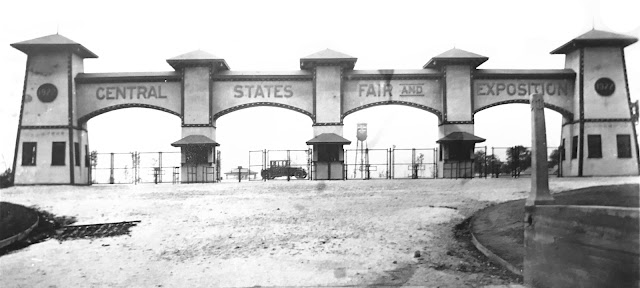
The decline came quickly after the war. Local people had their own automobiles. They could go longer distances for their entertainment. The opening in 1922 of the Central States Fair and Exposition (Exposition Park 1922-1931) in North Aurora was probably "the last nail in the coffin." Exposition Park featured a large swimming pool, many amusements and a race track. The ball fields at Exposition Park took away one of the major sources of revenue for Fox River Park. Finally, the interurban line to Yorkville was abandoned in January of 1925. It seems that Fox River Park was abandoned at the same time.

For several years after the close of the park, the old entrance light stands could be seen overgrown with weeds. The auditorium, the last building remaining on the property, was dismantled in the late 1920's. In addition, the old Fox River line city cars were scrapped on the siding in the late '20's. Even after the park was closed, Boy Scout outings were held on the campgrounds. 

The property was later sold. Part of it was subdivided and a large factory was built on a portion of the site. In recent years the factory has become the Montgomery plant of the Western Electric Company. The company has managed to maintain some of the beauty of the former wooded park along the banks of the Fox River. 

Compiled by Neil Gale, Ph.D. 

Exposition (Amusement) Park, Aurora, Illinois (1922-1931)

In 1921, Frank Thielen sold much of his investment in Aurora theaters and formed the Northern Illinois Fair Association, later to be known as the Central States Fair and Exposition Park. Founded on February 17, 1922, the 121 acre facility was located north of Aurora on North Lake Street Road (old Lincoln Highway). The facility grew to be one of the largest outdoor recreation centers in the Midwest.
The park operated from Easter until late fall, with the summer months being the busiest period; particularly the months of August and September, when the Central States Fair was held. The fair brought in as many as 75,000 persons during its usual nine day run. Agricultural exhibits and competition were the focuses of the fair, but fireworks, special band concerts, horse racing, auto racing, drum corps, balloon ascensions, and other attractions were added to the already long list of entertainment options available regularly at the park.
Front Entrance and Ticket Booth.

Fireworks, auto and airplane stunt shows, daredevils, locomotive collisions, and countless other unique forms of entertainment brought visitors in droves. The park also hosted sporting events such as baseball, wrestling, football, horse racing, auto racing and rodeos. Picnicking was always popular at the park.
Permanent offerings at Exposition Park included a 130 room hotel; the “world’s largest swimming pool,” measuring 320 feet by 160 feet; a race track with grand stand; a golf course; a beautiful pergola filled with imported flowers, birds and exotic animals; and a restaurant that later became a ballroom, roller skating rink and exhibit hall, situated in what was said to be the “world’s largest log cabin.” A “Kiddie Amusement Park” contained a roller coaster (the Exposition Flyer); tilt-a-whirl; Ferris wheel (the “Swooper”); a pony track; the House of Fun; “Monkey Island” with live monkeys; the “Ol’ Mill” boat rides; a penny arcade; “Leapin’ Leana” children’s playground; a miniature railroad (the “Exposition Limited’) and other attractions.
The largest crowds lasted throughout the 1920s, but depression years saw declining attendances. The Fair was ended after 1931, but the park remained opened on a limited scale until World War II. During the war, many of the buildings were used to house military goods. The merry-go-round and miniature railroad were sold to Chicago’s Riverview Park, and in 1957, the park was demolished to make room for new development. The Exposition park race track was revived as Aurora Downs but was not long lived.

Compiled by Neil Gale, Ph.D. 

Wednesday, August 22, 2018

The Southeast corner of Lake and LaSalle streets, Chicago

This is a balloon frame building on the Southeast  corner of Lake and LaSalle streets across from the Marine Bank building in 1856. The balloon frame structure built c.1845.

Abraham Lincoln Ribbons.

The above ribbon one is a Memoriam ribbon which was worn by people shortly after Lincoln’s assassination in April 1865; he was fifty-six years old.

The ribbon above was worn by people commemorating the 100th Anniversary of Abraham Lincoln’s birthdate of February 12, 1809.

Tuesday, August 21, 2018

The Ordinance of 1787 and Old Northwest Territory.

CLICK IMAGE FOR A FULL SIZE VIEW
The Ordinance of 1787 and Old Northwest Territory. This series of maps gives a capsular explanation of the evolution of the old "Northwest Territory" into the six states of Ohio, Indiana, Illinois, Michigan, Wisconsin and Minnesota. 

Willard F. Myrick (1809-1889), a brief biography of a Chicagoan.

Willard F. Myrick arrived in Chicago in October of 1836 from the shores of Lake Champlain, Vermont, where he was born. Soon after his arrival in Chicago, he bought 70 acres on the lakefront between the present 35th and 43rd streets.
Myrick's stockyard on 28th Street is an ancestor of Union Stock Yards. He opened "Myrick's House" in 1839 which was a noted stop for drovers and cattlemen to buy food and drinks and enjoy shadier entertainments. Over the next few years, Myrick added a hotel, barrack style apartments, a betting parlor, and a racing track at 29th and Cottage Grove. All flourished in the rapidly growing city, often to the dismay of respectable citizens. 
The drawing depicts Myrick's operation in the mid-1840s.
Chicago's first census shows 398 dwellings, grocery [EXPLANATION], and provisions stores and 29 (green) groceries. Taverns outnumbered churches but not lawyers.

In 1854 John B. Sherman bought it and expanded the operation. All the local stockyards were eventually acquired by Sherman and consolidated to form the massive Union Stockyards in 1865.

Myrick Avenue, now Vernon Avenue, was named after Willard F. Myrick. Myrick is buried in the Oak Woods Cemetery, Chicago.

Compiled by Neil Gale, Ph.D. 

Lost Towns of Illinois - Little Fort, Illinois and the Story of the Little Fort Lighthouse.


A number of small, temporary fortified trading posts were constructed by the French in the late seventeenth and early eighteenth centuries in what would be the Chicago and collar counties today. The exact location of most of these trading posts is uncertain, and, although they were sometimes referred to as "forts," there is no evidence of permanent French military fortifications in the area during this period. In the early 1700s, the Potawatomi took over this region from the Mascoutens and the Miamis tribes. The area (and any possible forts) was abandoned by the French in the 1720s during the Fox Wars. It was customary for the Indians to burn down the Europeans' forts and posts after their triumphs, unlike Europeans who would take over the fort and often rename it.


In the early 1700s, the Potawatomi took over this region from the Mascoutens and the Miamis tribes. The area (and any possible forts) was abandoned by the French in the 1720s during the Mesquakie (Fox) Wars. It was customary for the native peoples to burn down the Europeans' forts and posts after their triumphs, unlike Europeans who would take over the fort and often rename it.
About the Little Fort Settlement; Today's Waukegan, Illinois.
First visited by Father Jacques Marquette in 1673, Waukegan is one of the oldest communities in Illinois. The site was recorded as Rivière du Vieux Fort ("Old Fort River") and Wakaygagh on a 1778 map by Thomas Hutchins. The settlement started as a French trading post by a Potawatomi village sometime in the late 1600s. The French name was "Small Fort River" as translated from French to English. The settlement became known as "Little Fort."
Plat Map of "Little Fort" the City of Waukegan created in 1861 showing the block where the Little Fort actually stood in red. Click map for a full-size view.
On the 1861 plat map, the original blocks were numbered. On the section of the map above, the original "Little Fort" sat to the right of the dotted line, with the red arrow pointing to block 39. You can see block 38 above it and block 40 below. The left half, on the other side of the dotted line, is an addition to “Little Fort” at a later time and numbered within that addition.
Records dating back to 1829 tell of the Treaty of 1829[1] signed by the United Nations of the Potawatomi, Chippewa, and Ottawa tribes in which they ceded all of their lands in this area to the federal government.

The Little Fort Lighthouse
With the opening of the Erie Canal in the 1820s, a direct water passage was opened between the Great Lakes and New York, and the following thirty years witnessed an ever-increasing flow of immigrants seeking their fortunes in the growing number of settlements along the southern shore of  Lake Michigan. Situated between Milwaukee and Chicago, the area that would become Little Fort was deeply forested, with deep ravines leading down to the shore. The natural bounty of the area spurred both settlement and investment, and by the late 1830s vessels were anchoring offshore from the settlement, where lighters would be sent out to transport passengers and freight into the settlement.

After the construction of a private pier in 1841, vessels were finally able to make their way to shore, and in 1844, 151 vessels made their way into Little Fort, delivering almost a million feet of lumber, 250 tons of merchandise and furniture, 758 barrels of salt, 650 barrels of flour, 145 barrels of pork and beef, and loading 66,000 bushels of wheat, 200 bushels of oats, 200 pounds of furs, 8,000 pounds of hides and 15 barrels of pork. Seeking federal assistance for harbor improvements, Illinois Congressman John Wentworth presented a petition from citizens in Illinois and Wisconsin on January 5, 1846 "praying an appropriation for the construction of a harbor and the erection of a light-house at Little Fort, on Lake Michigan, in the State of Illinois." Congress appropriated $12,000 for harbor improvements that year and followed up with an additional appropriation of $4,000  in 1847 for the construction of a lighthouse to serve the new harbor.
The Little Fort keeper's dwelling showing the tower installed in 1860, and the picket fence installed in 1867.
Stephen Pleasonton, the Fifth Auditor of the Treasury, was responsible for the nation's aids to navigation at this time, and with no maritime background, his administration was typified by fiscal tightness. It is an unfortunate fact that most of the lighthouses built under his administration were built at minimum cost, and construction suffered as a result. Such was to be the case with the Little Fort Light, which was built under contract on a bluff a half-mile to the north of the harbor in 1849. While we know that the station consisted of a brick tower and detached wood-frame keepers dwelling, we have as yet been unable to identify any further information about the structure.

A year later, Henry B. Miller the Superintendent and Inspector of Lights on Northwest Lakes, arrived in Little Fort on July 18 while conducting his annual inspection of the lights in his district. In his report to Pleasonton, he stated that while he found the keeper to be conscientious and effective, he was dismayed with the condition in which he found the tower. It appeared that the brick used in its constructed was of inferior quality, being entirely too soft for use in such an exposed location. In effect serving as a sponge, the brick was absorbing moisture and subsequently flaking and cracking during the freeze/thaw cycle of the area's harsh winters. Concerned that the deterioration had advanced to the point that the entire structure needed re-facing with hard brick to permanently stem the deterioration, he was also well aware of the frugality under which the department was operated would make the availability of such funds virtually impossible, and thus he proposed that the sum of fifteen dollars be spent to effect a temporary repair through the re-pointing of the masonry and whitewashing of the tower's exterior.

In 1852, William B. Snowhook, the Collector and Superintendent of the Eleventh District under the newly formed Lighthouse Board, followed in Miller's footsteps and arrived in Little Fort while conducting his first inspection of the lights now under his supervision. Snowhook held no punches in his report, stating that he found the station to be "in a dilapidated condition, and defective in every respect." Observing that the temporary repairs made by the prior administration had done little to stem the deterioration of the tower's exterior surface, he went on to describe how he found the bricks in some areas to have crumbled to a point where a full three inches of their surface had disintegrated. He also noted that the gallery floor was lower at its center than at its circumference, rainwater was pooling on the floor and running into the lantern, damaging the iron of the lantern, stairs and the masonry within the tower.

Estimating that a complete repair would cost $10,500, he recommended that an appropriation be sought for the necessary funds, but also made a recommendation that would lay the groundwork for the future lighting of the harbor. Two years earlier, Congress had passed a bill appropriating $15,000 for the construction of breakwaters at Little Fort under the supervision of the Army Corps of Topographical Engineers. Snowhook observed this work underway, and realizing that a light of some type would be needed at the extremity of these breakwaters to guide vessels into the harbor, proposed that an iron beacon light be constructed at the northern end on their completion and that the existing Little Fort Light station be discontinued at that time since it would no longer serve any real purpose.

It would appear that Snowhook's recommendation was well received since Congress only approved $1,000 for the Lighthouse Board in 1860 to keep the Little Fort Light shining, but appropriated $10,500 for the Army Corps of Engineers to construct an iron pierhead beacon on the end of the new breakwater upon its completion.

With a mere $1,000 appropriation available for repairs at Little Fort, the Eleventh District Engineer was forced to seek a considerably less expensive alternative to keep the light shining until the new breakwater lights' completion. Conducting a complete survey of the station's structures, it was found that the keeper's dwelling was still in excellent condition, and thus a wooden tower with a standard octagonal cast iron lantern was constructed at the apex of its roof in 1860. With the relocation of the lens from the old brick tower, the new temporary Light was placed in service, and the crumbling brick tower was demolished.

Subsequent changes and additions in the harbor plan continued to delay the completion of the breakwaters, and with the Little Fort keeper's dwelling continuing to serve as the only light for the harbor, 1867 saw the construction of new outbuildings at the station, followed by the replacement of the roof in 1870.

Unbelievably, the arrival of 1880 found the Army Corps of Engineers still busy in the harbor, and without an apparent end in the work, it appeared that the "temporary" installation of the light atop the keeper's dwelling was fast becoming a permanent arrangement. Since the town of Waukegan was now encroaching on the station reservation on the bluff, a picket fence was constructed around the entire reservation to provide security.

Finally, in 1898 the work on the breakwaters was drawing to a close, and a temporary iron post supporting a white lens lantern was erected at the outer end of the north breakwater. With the construction of a small lamp cleaning building on the pier to provide keepers with a protected area in which to perform the constant maintenance required of the illuminating apparatus, this new light was exhibited for the first time on the night of August 10, 1898. With this new light in service, the "temporary" Fifth Order light installed on the Little Fort Keepers dwelling twenty years previous was permanently discontinued on December 31, 1889.

Little Fort became the county seat of government[2] in 1841 by virtue of its population. Between 1844 and 1846, the town's population grew from 150 to 750 people. In 1859 when the town was incorporated, the population had risen to 2,500.

Proud of the growth of their community and no longer wanting to be characterized as "little," the name "Waukegance" and then "Waukegan" (meaning "little fort"; from Potawatomi, Wakaigin "fort" or "fortress") was created by John H. Kinzie (John Kinzie's son) and Solomon Juneau, and the new name was adopted on March 31, 1849.

Early settlers were initially attracted to Waukegan as a port city and shipped produce and grain from Lake County and McHenry County farms to Chicago. The creation of the Illinois Parallel Railroad (now the Chicago and North Western Railway) in 1855 stimulated interest in Waukegan as a manufacturing center. The town continued to grow and diversify, and Waukegan was incorporated as a city on February 23, 1859, with an area of 5.62 square miles.
Above and below are current map sections showing where the "Little Fort" was with a red overlay.

Compiled by Neil Gale, Ph.D. 


[2] Treaty of July 29, 1829 - Ratified on January 2, 1830.
Articles of a treaty made and concluded at Prairie du Chien, in the Territory of Michigan, between the United States of America, by their Commissioners, General John McNeil, Colonel Pierre Menard, and Caleb Atwater, Esq. and the United Nations of Chippewa, Ottawa, and Potawatomi Indians, of the waters of the Illinois, Milwaukee, and Manitoouck Rivers.

ARTICLE I.
The aforesaid nations of Chippewa, Ottawa, and Potawatomi Indians, do hereby cede to the United States aforesaid, all the lands comprehended within the following limits, to wit: Beginning at the Winnebago Village, on Rock river, forty miles from its mouth, and running thence down the Rock River, to a line which runs due west from the most southern bend of Lake Michigan to the Mississippi River, and with that line to the Mississippi river opposite to Rock Island; thence, up that river, to the United States' reservation at the mouth of the Wisconsin; thence, with the south and east lines of said reservation, to the Wisconsin river; thence southerly, passing the heads of the small streams emptying into the Mississippi, to the Rock River aforesaid, at the Winnebago Village, the place of beginning. And, also, one other tract of land described as follows, to wit: Beginning on the Western Shore of Lake Michigan, at the northeast corner of the field of Antoine Ouilmette, who lives near Gross Pointe, about twelve miles north of Chicago; thence, running due west, to the Rock River, aforesaid; thence, down the said river, to where a line drawn due west from the most southern bend of Lake Michigan crosses said river; thence, east, along said line, to the Fox River of the Illinois; thence, along the northwestern boundary line of the cession of 1816, to Lake Michigan; thence, northwardly, along the Western Shore of said Lake, to the place of beginning.

ARTICLE II.
In consideration of the aforesaid cessions of land, the United States aforesaid agree to pay to the aforesaid nations of Indians the sum of sixteen thousand dollars, annually, forever, in specie: said sum to be paid at Chicago. And the said United States further agree to cause to be delivered to said nations of Indians, in the month of October next, twelve thousand dollars worth of goods as a present. And it is further agreed, to deliver to said Indians, at Chicago, fifty barrels of salt, annually, forever; and further, the United States agree to make permanent, for the use of the said Indians, the blacksmith's establishment at Chicago.

ARTICLE III.
From the cessions aforesaid, there shall be reserved, for the use of the under-named Chiefs and their bands, the following tracts of land:
For Wau-pon-eh-see, five sections of land at the Grand Bois, on Fox River of the Illinois, where Shaytee's Village now stands.

For Shab-eh-nay, two sections at his village near the Paw-paw Grove. For Awn-kote four sections at the village of Saw-meh-naug, on the Fox River of the Illinois.
ARTICLE IV.
There shall be granted by the United States, to each of the following persons, (being descendants from Indians,) the following tracts of land, viz: To Claude Laframboise, one section of land on the Riviere aux Pleins, adjoining the line of the purchase of 1816.
To Francois Bourbonné, Jr. one section at the Missionary establishment, on the Fox River of the Illinois. 

To Alexander Robinson, for himself and children, two sections on the Riviere aux Pleins, above and adjoining the tract herein granted to Claude Laframboise. 

To Pierre Leclerc, one section at the village of the As-sim-in-eh-Kon, or Paw-paw Grove. 

To Waish-kee-Shaw, a Potawatomi woman, wife of David Laughton, and to her child, one and a half sections at the old village of Nay-ou-Say, at or near the source of the Riviere aux Sables of the Illinois. 

To Billy Caldwell, two and a half sections on the Chicago River, above and adjoining the line of the purchase of 1816. 

To Victoire Pothier, one-half section on the Chicago River, above and adjoining the tract of land herein granted to Billy Caldwell. 

To Jane Miranda, one-quarter section on the Chicago River, above and adjoining the tract herein granted to Victoire Pothier. 
To Madeline, a Potawatomi woman, wife of Joseph Ogee, one section west of and adjoining the tract herein granted to Pierre Leclerc, at the Paw-paw Grove. 

To Archange Ouilmette, a Potawatomi woman, wife of Antoine Ouilmette, two sections, for herself and her children, on Lake Michigan, south of and adjoining the northern boundary of the cession herein made by the Indians aforesaid to the United States. 

To Antoine and Francois Leclerc, one section each, lying on the Mississippi River, north of and adjoining the line drawn due west from the most southern bend of Lake Michigan, where said line strikes the Mississippi River. 

To Mo-ah-way, one-quarter section on the north side of and adjoining the tract herein granted to Waish-Kee-Shaw. 
The tracts of land herein stipulated to be granted, shall never be leased or conveyed by the grantees, or their heirs, to any persons whatever, without the permission of the President of the United States.

ARTICLE V.
The United States, at the request of the Indians aforesaid, further agree to pay to the persons named in the schedule annexed to this treaty, the sum of eleven thousand six hundred and one dollars; which sum is in full satisfaction of the claims brought by said persons against said Indians, and by them acknowledged to be justly due.

ARTICLE VI.
And it is further agreed, that the United States shall, at their own expense, cause to be surveyed, the northern boundary line of the cession herein made, from Lake Michigan to the Rock River, as soon as practicable after the ratification of this treaty, and shall also cause good and sufficient marks and mounds to be established on said line.

ARTICLE VII.
The right to hunt on the lands herein ceded, so long as the same shall remain the property of the United States, is hereby secured to the nations who are parties to this treaty.

ARTICLE VIII.
This treaty shall take effect and be obligatory on the contracting parties, as soon as the same shall be ratified by the President of the United States, by and with the advice and consent of the Senate thereof.


[1] An Act to Incorporate the Town of Little Fort, Lake County, Illinois. 1841
Be it enacted by the People of the State of Illinois, represented in the General Assembly, That the resident  inhabitants of the Town of Little Fort, in Lake County, arc hereby constituted a body politic and corporate, to be known by the name of "the President and Trustees of the Town of Little Fort, and by that name shall be known in law, and have perpetual succession, may sue and be sued, plead and be impleaded, defend and be defended, in courts of "law and equity, and in all actions and matters whatsoever : may grant, purchase, receive and hold real and personal property within the limits of said Town, and no other, (burial grounds excepted,) and may lease, sell, and dispose of the same for the benefit of the Town, and may have power to lease any of the reserved lands, which have been or may be appropriated to the use of said Town, and may do all other acts as natural persons, which may be necessary to carry out the powers hereby granted, and may have a common seal and alter the same at pleasure.

Sunday, August 19, 2018

Downtown Joliet, Illinois. circa 1900

This is the interlocking tower in downtown Joliet, circa 1900, before the tracks in Joliet were elevated and relocated. This photo was taken from the roof of the Joliet Warehouse & Storage Company building, looking southwest.
The tracks running from left to right directly behind the tower belonged to the Chicago, Rock Island & Pacific Railroad.

The tracks running from the lower right to the center background belonged the Chicago & Alton Railroad.

The building in the center was the Chicago & Alton Railroad passenger depot.

The tracks running from the lower right side of the photo to the background on the left belonged to the Atchison, Topeka & Santa Fe Railroad.

In the background on the left were the tracks of the Michigan Central Railroad's Joliet Cut-Off.

Compiled by Neil Gale, Ph.D.