
A number of small, temporary fortified trading posts were constructed by the French in the late seventeenth and early eighteenth centuries in what would be the Chicago and collar counties today. The exact location of most of these trading posts is uncertain, and, although they were sometimes referred to as "forts," there is no evidence of permanent French military fortifications in the area during this period. In the early 1700s, the Potawatomi took over this region from the Mascoutens and the Miamis tribes. The area (and any possible forts) was abandoned by the French in the 1720s during the Fox Wars. It was customary for the Indians to burn down the Europeans' forts and posts after their triumphs, unlike Europeans who would take over the fort and often rename it.
In the early 1700s, the Potawatomi took over this region from the Mascoutens and the Miamis tribes. The area (and any possible forts) was abandoned by the French in the 1720s during the Mesquakie (Fox) Wars. It was customary for the native peoples to burn down the Europeans' forts and posts after their triumphs, unlike Europeans who would take over the fort and often rename it.

First visited by Father Jacques Marquette in 1673, Waukegan is one of the oldest communities in Illinois. The site was recorded as Rivière du Vieux Fort ("Old Fort River") and Wakaygagh on a 1778 map by Thomas Hutchins. The settlement started as a French trading post by a Potawatomi village sometime in the late 1600s. The French name was "Small Fort River" as translated from French to English. The settlement became known as "Little Fort."
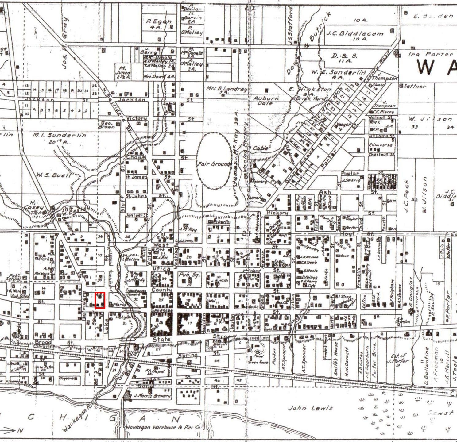 |
| Plat Map of "Little Fort" the City of Waukegan created in 1861 showing the block where the Little Fort actually stood in red. Click map for a full-size view. |
 |
| On the 1861 plat map, the original blocks were numbered. On the section of the map above, the original "Little Fort" sat to the right of the dotted line, with the red arrow pointing to block 39. You can see block 38 above it and block 40 below. The left half, on the other side of the dotted line, is an addition to “Little Fort” at a later time and numbered within that addition. |
The Little Fort Lighthouse
With the opening of the Erie Canal in the 1820s, a direct water passage was opened between the Great Lakes and New York, and the following thirty years witnessed an ever-increasing flow of immigrants seeking their fortunes in the growing number of settlements along the southern shore of Lake Michigan. Situated between Milwaukee and Chicago, the area that would become Little Fort was deeply forested, with deep ravines leading down to the shore. The natural bounty of the area spurred both settlement and investment, and by the late 1830s vessels were anchoring offshore from the settlement, where lighters would be sent out to transport passengers and freight into the settlement.
After the construction of a private pier in 1841, vessels were finally able to make their way to shore, and in 1844, 151 vessels made their way into Little Fort, delivering almost a million feet of lumber, 250 tons of merchandise and furniture, 758 barrels of salt, 650 barrels of flour, 145 barrels of pork and beef, and loading 66,000 bushels of wheat, 200 bushels of oats, 200 pounds of furs, 8,000 pounds of hides and 15 barrels of pork. Seeking federal assistance for harbor improvements, Illinois Congressman John Wentworth presented a petition from citizens in Illinois and Wisconsin on January 5, 1846 "praying an appropriation for the construction of a harbor and the erection of a light-house at Little Fort, on Lake Michigan, in the State of Illinois." Congress appropriated $12,000 for harbor improvements that year and followed up with an additional appropriation of $4,000 in 1847 for the construction of a lighthouse to serve the new harbor.
 |
| The Little Fort keeper's dwelling showing the tower installed in 1860, and the picket fence installed in 1867. |
A year later, Henry B. Miller the Superintendent and Inspector of Lights on Northwest Lakes, arrived in Little Fort on July 18 while conducting his annual inspection of the lights in his district. In his report to Pleasonton, he stated that while he found the keeper to be conscientious and effective, he was dismayed with the condition in which he found the tower. It appeared that the brick used in its constructed was of inferior quality, being entirely too soft for use in such an exposed location. In effect serving as a sponge, the brick was absorbing moisture and subsequently flaking and cracking during the freeze/thaw cycle of the area's harsh winters. Concerned that the deterioration had advanced to the point that the entire structure needed re-facing with hard brick to permanently stem the deterioration, he was also well aware of the frugality under which the department was operated would make the availability of such funds virtually impossible, and thus he proposed that the sum of fifteen dollars be spent to effect a temporary repair through the re-pointing of the masonry and whitewashing of the tower's exterior.
In 1852, William B. Snowhook, the Collector and Superintendent of the Eleventh District under the newly formed Lighthouse Board, followed in Miller's footsteps and arrived in Little Fort while conducting his first inspection of the lights now under his supervision. Snowhook held no punches in his report, stating that he found the station to be "in a dilapidated condition, and defective in every respect." Observing that the temporary repairs made by the prior administration had done little to stem the deterioration of the tower's exterior surface, he went on to describe how he found the bricks in some areas to have crumbled to a point where a full three inches of their surface had disintegrated. He also noted that the gallery floor was lower at its center than at its circumference, rainwater was pooling on the floor and running into the lantern, damaging the iron of the lantern, stairs and the masonry within the tower.
Estimating that a complete repair would cost $10,500, he recommended that an appropriation be sought for the necessary funds, but also made a recommendation that would lay the groundwork for the future lighting of the harbor. Two years earlier, Congress had passed a bill appropriating $15,000 for the construction of breakwaters at Little Fort under the supervision of the Army Corps of Topographical Engineers. Snowhook observed this work underway, and realizing that a light of some type would be needed at the extremity of these breakwaters to guide vessels into the harbor, proposed that an iron beacon light be constructed at the northern end on their completion and that the existing Little Fort Light station be discontinued at that time since it would no longer serve any real purpose.
It would appear that Snowhook's recommendation was well received since Congress only approved $1,000 for the Lighthouse Board in 1860 to keep the Little Fort Light shining, but appropriated $10,500 for the Army Corps of Engineers to construct an iron pierhead beacon on the end of the new breakwater upon its completion.
With a mere $1,000 appropriation available for repairs at Little Fort, the Eleventh District Engineer was forced to seek a considerably less expensive alternative to keep the light shining until the new breakwater lights' completion. Conducting a complete survey of the station's structures, it was found that the keeper's dwelling was still in excellent condition, and thus a wooden tower with a standard octagonal cast iron lantern was constructed at the apex of its roof in 1860. With the relocation of the lens from the old brick tower, the new temporary Light was placed in service, and the crumbling brick tower was demolished.
Subsequent changes and additions in the harbor plan continued to delay the completion of the breakwaters, and with the Little Fort keeper's dwelling continuing to serve as the only light for the harbor, 1867 saw the construction of new outbuildings at the station, followed by the replacement of the roof in 1870.
Unbelievably, the arrival of 1880 found the Army Corps of Engineers still busy in the harbor, and without an apparent end in the work, it appeared that the "temporary" installation of the light atop the keeper's dwelling was fast becoming a permanent arrangement. Since the town of Waukegan was now encroaching on the station reservation on the bluff, a picket fence was constructed around the entire reservation to provide security.
Finally, in 1898 the work on the breakwaters was drawing to a close, and a temporary iron post supporting a white lens lantern was erected at the outer end of the north breakwater. With the construction of a small lamp cleaning building on the pier to provide keepers with a protected area in which to perform the constant maintenance required of the illuminating apparatus, this new light was exhibited for the first time on the night of August 10, 1898. With this new light in service, the "temporary" Fifth Order light installed on the Little Fort Keepers dwelling twenty years previous was permanently discontinued on December 31, 1889.
Little Fort became the county seat of government[2] in 1841 by virtue of its population. Between 1844 and 1846, the town's population grew from 150 to 750 people. In 1859 when the town was incorporated, the population had risen to 2,500.
Proud of the growth of their community and no longer wanting to be characterized as "little," the name "Waukegance" and then "Waukegan" (meaning "little fort"; from Potawatomi, Wakaigin "fort" or "fortress") was created by John H. Kinzie (John Kinzie's son) and Solomon Juneau, and the new name was adopted on March 31, 1849.
Early settlers were initially attracted to Waukegan as a port city and shipped produce and grain from Lake County and McHenry County farms to Chicago. The creation of the Illinois Parallel Railroad (now the Chicago and North Western Railway) in 1855 stimulated interest in Waukegan as a manufacturing center. The town continued to grow and diversify, and Waukegan was incorporated as a city on February 23, 1859, with an area of 5.62 square miles.
 |
| Above and below are current map sections showing where the "Little Fort" was with a red overlay. |

Compiled by Neil Gale, Ph.D.
[2] Treaty of July 29, 1829 - Ratified on January 2, 1830.
Articles of a treaty made and concluded at Prairie du Chien, in the Territory of Michigan, between the United States of America, by their Commissioners, General John McNeil, Colonel Pierre Menard, and Caleb Atwater, Esq. and the United Nations of Chippewa, Ottawa, and Potawatomi Indians, of the waters of the Illinois, Milwaukee, and Manitoouck Rivers.
ARTICLE I.
The aforesaid nations of Chippewa, Ottawa, and Potawatomi Indians, do hereby cede to the United States aforesaid, all the lands comprehended within the following limits, to wit: Beginning at the Winnebago Village, on Rock river, forty miles from its mouth, and running thence down the Rock River, to a line which runs due west from the most southern bend of Lake Michigan to the Mississippi River, and with that line to the Mississippi river opposite to Rock Island; thence, up that river, to the United States' reservation at the mouth of the Wisconsin; thence, with the south and east lines of said reservation, to the Wisconsin river; thence southerly, passing the heads of the small streams emptying into the Mississippi, to the Rock River aforesaid, at the Winnebago Village, the place of beginning. And, also, one other tract of land described as follows, to wit: Beginning on the Western Shore of Lake Michigan, at the northeast corner of the field of Antoine Ouilmette, who lives near Gross Pointe, about twelve miles north of Chicago; thence, running due west, to the Rock River, aforesaid; thence, down the said river, to where a line drawn due west from the most southern bend of Lake Michigan crosses said river; thence, east, along said line, to the Fox River of the Illinois; thence, along the northwestern boundary line of the cession of 1816, to Lake Michigan; thence, northwardly, along the Western Shore of said Lake, to the place of beginning.
ARTICLE II.
In consideration of the aforesaid cessions of land, the United States aforesaid agree to pay to the aforesaid nations of Indians the sum of sixteen thousand dollars, annually, forever, in specie: said sum to be paid at Chicago. And the said United States further agree to cause to be delivered to said nations of Indians, in the month of October next, twelve thousand dollars worth of goods as a present. And it is further agreed, to deliver to said Indians, at Chicago, fifty barrels of salt, annually, forever; and further, the United States agree to make permanent, for the use of the said Indians, the blacksmith's establishment at Chicago.
ARTICLE III.
From the cessions aforesaid, there shall be reserved, for the use of the under-named Chiefs and their bands, the following tracts of land:
For Wau-pon-eh-see, five sections of land at the Grand Bois, on Fox River of the Illinois, where Shaytee's Village now stands.ARTICLE IV.
For Shab-eh-nay, two sections at his village near the Paw-paw Grove. For Awn-kote four sections at the village of Saw-meh-naug, on the Fox River of the Illinois.
There shall be granted by the United States, to each of the following persons, (being descendants from Indians,) the following tracts of land, viz: To Claude Laframboise, one section of land on the Riviere aux Pleins, adjoining the line of the purchase of 1816.
To Francois Bourbonné, Jr. one section at the Missionary establishment, on the Fox River of the Illinois.The tracts of land herein stipulated to be granted, shall never be leased or conveyed by the grantees, or their heirs, to any persons whatever, without the permission of the President of the United States.
To Alexander Robinson, for himself and children, two sections on the Riviere aux Pleins, above and adjoining the tract herein granted to Claude Laframboise.
To Pierre Leclerc, one section at the village of the As-sim-in-eh-Kon, or Paw-paw Grove.
To Waish-kee-Shaw, a Potawatomi woman, wife of David Laughton, and to her child, one and a half sections at the old village of Nay-ou-Say, at or near the source of the Riviere aux Sables of the Illinois.
To Billy Caldwell, two and a half sections on the Chicago River, above and adjoining the line of the purchase of 1816.
To Victoire Pothier, one-half section on the Chicago River, above and adjoining the tract of land herein granted to Billy Caldwell.
To Jane Miranda, one-quarter section on the Chicago River, above and adjoining the tract herein granted to Victoire Pothier.
To Madeline, a Potawatomi woman, wife of Joseph Ogee, one section west of and adjoining the tract herein granted to Pierre Leclerc, at the Paw-paw Grove.
To Archange Ouilmette, a Potawatomi woman, wife of Antoine Ouilmette, two sections, for herself and her children, on Lake Michigan, south of and adjoining the northern boundary of the cession herein made by the Indians aforesaid to the United States.
To Antoine and Francois Leclerc, one section each, lying on the Mississippi River, north of and adjoining the line drawn due west from the most southern bend of Lake Michigan, where said line strikes the Mississippi River.
To Mo-ah-way, one-quarter section on the north side of and adjoining the tract herein granted to Waish-Kee-Shaw.
ARTICLE V.
The United States, at the request of the Indians aforesaid, further agree to pay to the persons named in the schedule annexed to this treaty, the sum of eleven thousand six hundred and one dollars; which sum is in full satisfaction of the claims brought by said persons against said Indians, and by them acknowledged to be justly due.
ARTICLE VI.
And it is further agreed, that the United States shall, at their own expense, cause to be surveyed, the northern boundary line of the cession herein made, from Lake Michigan to the Rock River, as soon as practicable after the ratification of this treaty, and shall also cause good and sufficient marks and mounds to be established on said line.
ARTICLE VII.
The right to hunt on the lands herein ceded, so long as the same shall remain the property of the United States, is hereby secured to the nations who are parties to this treaty.
ARTICLE VIII.
This treaty shall take effect and be obligatory on the contracting parties, as soon as the same shall be ratified by the President of the United States, by and with the advice and consent of the Senate thereof.
[1] An Act to Incorporate the Town of Little Fort, Lake County, Illinois. 1841
Be it enacted by the People of the State of Illinois, represented in the General Assembly, That the resident inhabitants of the Town of Little Fort, in Lake County, arc hereby constituted a body politic and corporate, to be known by the name of "the President and Trustees of the Town of Little Fort, and by that name shall be known in law, and have perpetual succession, may sue and be sued, plead and be impleaded, defend and be defended, in courts of "law and equity, and in all actions and matters whatsoever : may grant, purchase, receive and hold real and personal property within the limits of said Town, and no other, (burial grounds excepted,) and may lease, sell, and dispose of the same for the benefit of the Town, and may have power to lease any of the reserved lands, which have been or may be appropriated to the use of said Town, and may do all other acts as natural persons, which may be necessary to carry out the powers hereby granted, and may have a common seal and alter the same at pleasure.
No comments:
Post a Comment
The Digital Research Library of Illinois History Journal™ is RATED PG-13. Please comment accordingly. Advertisements, spammers and scammers will be removed.