In 1961, Gertrude Kerbis, with the architectural firm of Naeas & Murphy, later known as C.F. Murphy, designed the Seven Continents/ O'Hara Airport Rotunda Building as a multi-purpose structure housing several restaurants and airport functions. It served as a magnificent passenger link connecting two major airport terminals. The Rotunda Building is a Jet Age design that was once the centerpiece of Chicago's O'Hare International Airport and is an excellent example of Mid-century modern airport architecture.
 |
| Seven Continents Building / O'Hare Rotunda Building, exterior view. |
Gertrude Kerbis was a groundbreaking architect and one of the first women at the forefront of Chicago architecture, working in the modern style in the 1960s. She studied with Walter Gropius at Harvard and Ludwig Mies van der Rohe at IIT—Illinois Institute of Technology in Chicago. Kerbis worked with Skidmore, Owings & Merrill (SOM), and later at Naeas & Murphy/C.F. Murphy. She opened her own architectural firm, Lempp Kerbis Architects, in 1967. Kerbis was one of the few female architects working in a male-dominated profession. She worked on the original O'Hare Terminal structures and the Chicago Civic Center, now known as the Richard J. Daley Center, a designated Chicago Landmark.
 |
| Seven Continents Building / O'Hare Rotunda Building, exterior view. |
Kerbis designed the Seven Continents Rotunda Building using an elaborate structural system consisting of one mile of heavy bridge cables spanning a 190-foot ceiling and measuring approximately five inches in thickness, considered by some to be a structural feat. This system resembles a sunburst pattern sheathed in concrete visible from the floor of this unique circular, public, two-story space. The Rotunda Building remains largely intact today but has faded from public use due to the closing of the original restaurants, the expansion of O'Hare Airport, and the difficulty of accessing the building beyond added security checkpoints.
Preservation Chicago advocates for a greater appreciation, recognition, restoration, and Chicago Landmark status for this iconic building. The Seven Continents Rotunda Building should be retained and restored as an extensive $8.5 billion O'Hare modernization effort is about to begin.
HISTORY
Before O'Hare Airport was built, Chicago's Midway Airport (initially named Chicago Municipal Airport) on the Southwest Side of Chicago was the busiest in the country. Midway Airport was suffering from overcrowding and a lack of space for expansion. Orchard Field, a site northwest of the city, had 10 times the land that Midway occupied and was chosen in 1945 as a site for a new airport to be built. The airport opened to commercial air traffic in 1966. In the 1960s, work began on two new terminals, infrastructure, and support buildings for what is now known as O'Hare International Airport. The architectural firm of Naess & Murphy/C.F. Murphy Associates was commissioned to design most of this early work, completed in 1963.
 |
| The grand concourse connecting Terminals 1 and 2 with entry to the Seven Continents Restaurant on the mezzanine and the Tartan Tray Coffee Shop on ground level, circa 1963, with original oculus skylight and lighting before extensive modifications. Seven Continents Building / O'Hare Rotunda Building, interior view. |
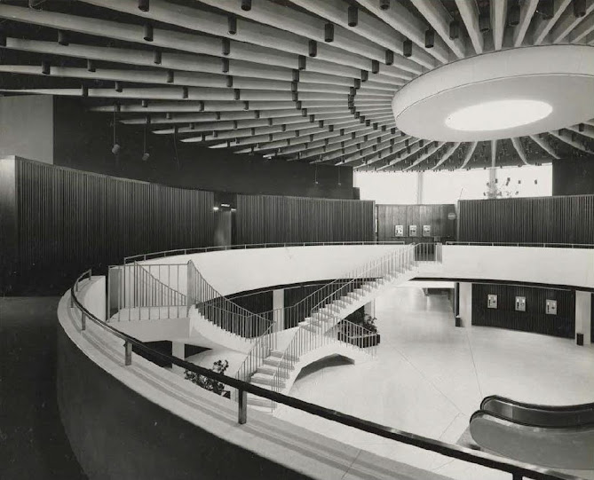
The Seven Continents Rotunda Building, designed by Gertrude Kerbis during her time at Naess & Murphy/C.F. Murphy Associates, was centrally located between the first two terminals at O'Hare Airport. The circular form of the Rotunda Building is covered by a shallow roof dome consisting of a concrete shell hung by metal cables from a steel support structure overhead. The circular two-story atrium at the building's central core was also a terminal passageway and a grand space. It contains two floating sculptural staircases leading to a balcony on the mezzanine level above, which also wraps around the perimeter of the open atrium.
The building's interior perimeter also included restaurants and a bar. People could gather, watch airplanes take off & land, and board on the adjacent tarmacs visible through the expansive two-story windows.
The first level of the building contained an informal dining room, coffee shop, lunch counter, pancake shop, and cocktail lounge, all of which conformed to the curved perimeter of the building's exterior. In a soaring, two-story space with a cantilevered mezzanine on the second level, the mezzanine level appears to float within the larger space. This was a brilliant use and program, forming a universal space for two distinct dining establishments stacked upon one another: a casual dining room and an elegant dining facility.
The casual dining room and a coffee shop called 'The Tartan Tray' referred to the Scotsmen who had founded the Chicago-based Carson Pirie Scott & Company [1] department store. The Carson Pirie Scott & Co. store at 1 South State Street at the corner of East Madison Street in Chicago's Loop had the Tartan Tray Cafeteria on the basement level.
It was part of Carson's immense restaurant and food service division. Carson's operation provided food service to its regional stores, cafes within the airport, and in-flight meals to airline passengers. Many of these meals were prepared on the ground floor/lower level of the building within the vast kitchens at the tarmac level. The ground floor included a bakery, offices, storage, mechanical and electrical, and an employee cafeteria.
 |
| Seven Continents Rotunda Building, with a view of the skylight and lighting after extensive and insensitive modifications. |
The mezzanine level, accessed in the two-story circular atrium core by the two floating staircases previously mentioned, was the location of the famed Seven Continents Restaurant and a second kitchen. It also included five private dining rooms that could be combined into one larger space. The Seven Continents Restaurant provided a fine dining experience where travelers worldwide could enjoy a meal in a sophisticated setting overlooking the airfield and surrounded by art. They could also watch airplanes take off and land through expansive windows. The Seven Continents Restaurant became a destination for elegant dining, even those not leaving the city on a plane. It was dining at its best and was said to once rival restaurants elsewhere in the region. The building was known simply as "The Seven Continents," although it contained a vastly complex program of services and wide passages connecting two massive termini for airline customers.
During the 1960s, airports throughout the country were expanding futuristic structures to reflect the excitement of the Jet Age. In 1960, Pan Am built the flying saucer-shaped Worldport at John F. Kennedy (JFK) Airport, designed by Ives, Turano & Gardner Associated Architects, and Walther Prokosch ofTippets-AbbettMcDarthy- Stratton. Sadly, Worldport was demolished in 2013. In 1962, Eero Saarinen's TWA Flight Center at JFK opened, and that same year, Saarinen's terminal at Dulles International Airport outside of Washington, D.C., was dedicated by President John F. Kennedy. While portions of the original TWA Flight Center have been reconfigured, the Saarinen-designed head house at JFK has been renovated and now serves as a destination hotel for travelers. Eero Saarinen's Dulles Main Terminal remains a well-known landmark. In 1961, the Los Angeles International Airport LAX opened its Theme Building by William Pereira and Charles Luckman. This iconic flying saucer on stilts design remains at LAX.
Completed in 1963, the centerpiece of Chicago's new O'Hare International Airport was the Rotunda Building, designed by Gertrude Kerbis. The Rotunda Building remains largely intact and is one of the few remaining elements of O'Hare's Jet Age design and C.F. Murphy's contributions to this critical early airport design. O'Hare's Rotunda Building was notable for its design and trailblazing female architect, who was at the forefront of Chicago architecture, working in the modern style in the 1960s.
 |
| Seven Continents Building / O'Hare Rotunda Building, exterior rendering. |
 |
| Seven Continents Building / O'Hare Rotunda Building, interior rendering. |
Gertrude Kerbis was born in 1926 to German and Russian immigrant parents on Chicago's Northwest Side. She had been attending the University of Wisconsin when she became inspired by a Life magazine article on Frank Lloyd Wright. This prompted her to travel from Madison to Wright's Taliesin estate in Spring Green, Wisconsin. Gertrude became ecstatic by the interior rooms as she peered through the glass of Talies and managed to climb through a window to spend the night there. In a short film about her life, Kerbis recalled that she knew she wanted to become an architect when she awoke.
The University of Wisconsin did not have an architecture school, so she transferred to the University of Illinois at Urbana-Champaign. Graduating in 1948 with a bachelor of science in architectural engineering. She then attended Harvard University's Graduate School of Design and studied with architect Walter Gropius. Gertrude left Harvard to attend Chicago's Illinois Institute of Technology, where she studied under Ludwig Mies van der Rohe. She graduated from IIT in 1954 with a master's in architecture and planning.
 |
| Seven Continents Building / O'Hare Rotunda Building, construction aerial view. |
Gertrude Kerbis began her career in the drafting room of the Chicago architectural firm Skidmore, Owings & Merrill (SOM), where she was one of the few women. While at SOM, she designed a futuristic cadet dining hall at the U.S. Air Force Academy campus in Colorado Springs, Colorado. The dining hall was designed to serve thousands of cadets at one time. Before leaving SOM, she designed the Skokie Public Library, which won national design honors from AI. Working at Naess & Murphy/C.F. Murphy & Associates from 1959 to 1967, Kerbis designed the Rotunda Building at the newly built Chicago O'Hare International Airport. Starting her own firm in 1967, she took on the unusual role of simultaneously designing and developing her projects. These projects included the award-winning Green House Condominiums at 2131 N. Clark Street and a Highland Park tennis club for her second husband, tennis pro-Don Kerbis. She also taught architecture at Harper College in Palatine and helped find the omen in Architecture. Kerbis's group supported women in architecture and strived to show what a woman can accomplish by example.
 |
| Seven Continents Building / O'Hare Rotunda Building original ceiling plan and staircase details. |
Gertrude Kerbis's daughter, Kim, said: "Trailblazing Chicagoan Gertrude Lempp Kerbis became an architect at a time when most women in the field were either receptionists, secretaries, or relegated to the interior departments despite their qualifications. Inspired by and then studying and working with modern masters, she forged a unique career that merged her engineering passions with her modernist aesthetic, fierce independence with a desire to strengthen the architectural community (particularly for women), and her continued pursuit of individual architectural excellence with a desire to pass those skills on to the next generation of architects. Modern architecture made its mark on Gertrude Lempp Kerbis, and in return, she left her mark on it."
THE SEVEN CONTINENTS RESTAURANT
Seven Continents restaurant opened in the Rotunda building in Terminal 3 in 1963 as a fine-dining restaurant at O'Hare International Airport. The waiters wore tuxedo jackets, busboys filled and refilled water from Sterling Silver pitchers, white-clot, and hed tables were adorned with fresh-cut flowers and pretty glassware. Seven Continents was on the upper level of the rotunda that connects terminals 2 and 3. Once upon a time, that meant that Seven Continents' neighbors were United Airlines and American Airlines.

The dining room was black and dark brown; the soft, low-backed booths closest to the windows afford views of several American gates, and a couple of the restaurant's names suggest a global menu. Still, in fact, the selections were all-American. There was a lot of seafood among the selections, all fresh, flown in fresh daily. The Seven Continents restaurant's signature entree was made from Chicken Kyiv from scratch. Many diners had planes to catch, and the kitchen tended to crank out the food quickly. The atmosphere was rather like a 'round-the-clock pre-theater hour.' Diners tend not to dawdle. On the plus side, the food hit the table hot; the waiters seem to know instinctively who's on a timetable and who isn't, and diners never feel rushed.
Seven Continents restaurant closed in November 1994.
THREATS TO THE ROTUNDA BUILDING
Planning called for a new global terminal to replace O'Hare's Terminal 2. The Rotunda Building is directly adjacent to the $8.5 billion expansion project. With the Seven Continents Restaurant, shops, and public gathering places closed or modified, the Rotunda Building now serves as a vestibule and throughway and houses TSA offices. It has been remodeled over time, with oversized advertising to Terminal 3's Concourse G. A new control tower built adjacent to the Rotunda Building blocks the visibility of this architectural gem.
Preservation Chicago was concerned that the Rotunda Building wouldn't be adequately valued during the most significant and extensive airport expansion. The potential failure to recognize this critical Midcentury Modern building by a trailblazing woman architect could result in an inappropriate treatment or possible demolition.
Preservation Chicago has submitted a landmark suggestion for the Seven Continents Rotunda Building to the Commission on Chicago Landmarks and Land. Landmarks included Gertrude K.erbis' Rotunda Building on their Landmarks Illinois' Most Endangered List in 2017. These recommendations have been made, but the building does not have a Landmark designation or any protections to date.
PRESERVATION RECOMMENDATIONS
Preservation Chicago supports a Chicago Landmark designation for the Seven Continents Rotunda Building and a complete restoration. The structure meets and fulfills four of the seven criteria set forth for the Proposed Designation of Chicago Landmarks, and it is the fugacity criterion" required for Landmark designation. Landmark status would protect the Rotunda Building from neglect or demolition as O'Hare Airport plans for the future. With the $8.5 million modernization effort and replacement of Terminal 2, we hope the Building will be restored and returned to become a lively center of activity. With new uses that both honor and restore the integrity of this remarkable structure and its complex and sophisticated spaces and finishes, it can be enjoyed by the public once again. Suppose the positioning of the Rotunda Building will not allow for it to function as a public thoroughfare. In that case, it should be considered a particular lounge area with an acceptable dining option.
 |
| Seven Continents Building / O'Hare Rotunda Building, interior view of stairs. |
 |
| Seven Continents Restaurant on the mezzanine level of the Rotunda Building, Seven Continents Restaurant interior view. |
There has been an effort at airports nationwide to restore and reuse the Midcentury Modern airport buildings. The TWA Flight Center headhouse by Saarinen at JFK is being redeveloped as a hotel, and the Theme Building at LAX by Pereira and Luckman is anticipated to be preserved in the airport's master planning efforts. The Rotunda Building should be included in this group of Jet Age, Midcentury Modern airport architecture.
 |
| Expansive view of O'Hare airfield from the ground floor Tartan Tray Coffee Shop. |
Gertrude Kerbis and this incredible structure should be honored in March 2019 for Women's History Month. Chicago Landmark designation would adequately honor the Rotunda Building's place in women's 20th-century achievements in architecture and aviation, and it would protect it during current and future expansion plans at O'Hare. After years of additions and remodeling throughout O'Hare Airport, the Rotunda Building has endured, and it is as enjoyable, fresh, and relevant as ever.
Preservation Chicago was instrumental in working with the Kerbis family to facilitate a donation of drawings, photographs, papers, and other archival materials to the Ryerson and Burnham Libraries at the Art Institute of Chicago.
 |
| Owned and operated by Carson, Pirie, Scott & Co., the Seven Continents Restaurant was the white-tablecloth "oasis of civility in busy O'Hare Airport" located on the mezzanine level above the Tartan Tray Coffee Shop on the ground floor below. |
 |
| Kerbis, one of the first women architects in the modern style, studied with Mies van der Rohe at IIT. In 1958, she designed the dining hall at the U.S. Air Force Academy in Colorado Springs while working at Skidmore Owings and Merrill (SOM). She later went on to teach and form her own practice. Kerbis was a founding member of Women in Architecture. She received the AIA Lifetime Achievement Award in 2008. A fascinating story told by a fantastic woman. |
Compiled by Dr. Neil Gale, Ph.D.
 |
Carson Pirie Scott & Co.
Tartan Tray Cafeteria, Chicago. |
[1] Carson Pirie Scott & Co. (1854─2007). The chain began in 1854 when Scotsmen Samuel Carson and John Pirie first clerked in Murray's dry goods store in Peru, Illinois - then opened their own store in LaSalle, Illinois, followed by one in Amboy, Illinois. The Great Chicago Fire destroyed 60% of the store's stock in 1871. John Edwin Scott operated a dry goods store in Ottawa, Illinois. He later moved up to Chicago and became the first partner of Samuel Carson and John T. Pirie in the owner-owned store, which was owned by Pirie Scott & Co.
In 1961, Carson Pirie Scott & Co. expanded in Illinois by purchasing the 20-unit Block & Kuhl chain headquartered in Peoria. In 1980, to diversify its business, Carson Pirie Scott & Co. borrowed $108 million to buy Dobbs Houses, Inc., an airline caterer and owner of the Toddle House and Steak 'n Egg Kitchen restaurant chains. These were sold in 1988, as was the County Seat clothing chain.
In 1989, Carson Pirie Scott & Co. was acquired by P.A. Bergner & Co. (founded in Peoria), who operated the Bergner's, Charles V. Weise, Myers Brothers, and Boston Store chains. In 1991, P.A. Bergner & Co. filed for Chapter 11 bankruptcy; upon emerging from bankruptcy in 1993, it became a NASDAQ publicly traded company, changing its operating name to Carson Pirie Scott & Co. One year later, the company commenced trading on the NYSE under the CRP symbol.
By 1998, Carson Pirie Scott & Co. ownership was held by Proffitt's, Inc. (later renamed Saks Incorporated to reflect the acquisition of Saks Fifth Avenue). The Carson Pirie Scott, Bergner's, and Boston Store chains, along with Younkers and Herberger's nameplates, eventually operated as Saks' Northern Department Store Group (NDSG), based in Milwaukee, Wisconsin. In late 2005, however, the group was put up for sale as Saks Incorporated tried to refocus itself primarily on its core Saks Fifth Avenue stores.
Carson's and its associated stores became part of The Bon-Ton Stores Inc. in a $1.1 billion deal completed on March 6, 2006. The group's merchandising and marketing base remained in Milwaukee. Bon-Ton converted Elder-Beerman stores in Indiana and Michigan to the newly shortened Carson's name in 2011 and 2012. The chain expanded into Metro Detroit in 2013 by converting three Parisian stores. Bon-Ton announced on April 17, 2018, that they would cease operations and began liquidating all 267 stores after two liquidators, Great American Group and Tiger Capital Group, won an auction for the company. The bid was estimated to be worth $775.5 million. This included all remaining Carson's stores after 164 years of operation. According to Nationalporter Mitch Nolen, stores are supposed to open within 10 to 12 weeks.
The intellectual property of Bon-Ton, including Carson's, was quickly sold in bankruptcy to CSC Generation, and online retail was reopened. The new owners, based in Merrillville, Indiana, also explored opening new store locations. On October 29, 2018, Under this new ownership and using the same company and stores' names, Bon-Ton started announcing it would reopen the Evergreen Park, Illinois Carson's store on November 24 (Black Friday)–one of Bon-Ton's first brick-and-mortar stores to reopen. Bon-Ton had announced plans to open brick-and-mortar Carson's stores in Bloomingdale, Lombard, and Orland Park. The only location to open was in Evergreen Park. The company never opened Bloomingdale, Lombard, or Orland Park. The Evergreen Park location closed in October 2020 due to the COVID-19 Pandemic.