Tuesday, October 16, 2018

Fort Johnson (1814), and Cantonment Davis (1815-1816), Warsaw, Illinois.

Nestled high upon a bluff within Warsaw, Illinois, and overlooking the former confluence of the Des Moines and Mississippi rivers lies a large residential yard dotted with a few evergreen trees. Hidden within the sod of this tranquil setting are remnants of two American military posts dating to the War of 1812 period. These military posts are known today as Fort Johnson and Cantonment Davis[1].

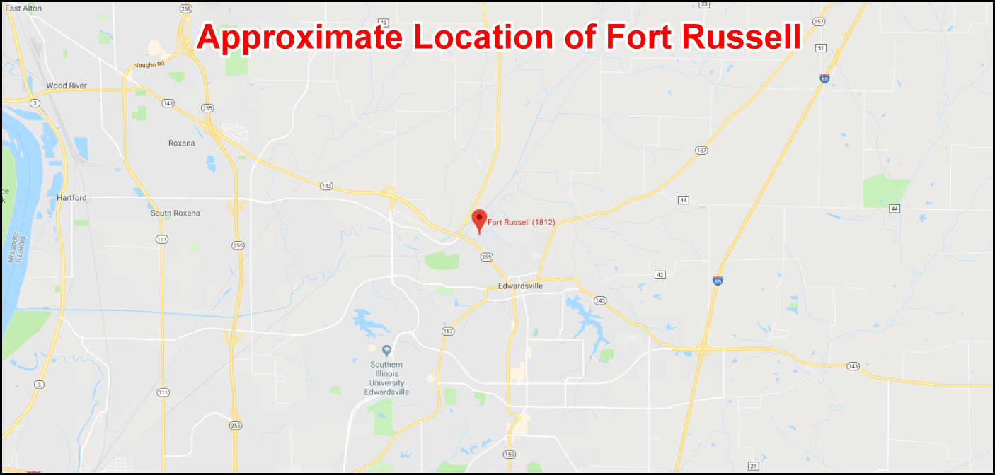
There are letters from William Henry Harrison Sr., the future 9th President of the United States, dated 1807, the Governor of the Indian Territory (1801-1812) requiring all settlements to have a small fort or blockhouse constructed.
Established in the late summer–early fall of 1814 to defend what was then the western frontier of the United States against the British and their Indian allies, Fort Johnson was constructed by future president Zachary Taylor under the watchful eye of Sauk leader Black Hawk, who were hiding on a nearby hill. Fort Johnson was a U.S. Army post and stockaded fort about 100 feet square with two timber blockhouses, a stone powder magazine, and several barracks and quarters.

The commander of the fort, James Callaway, was the grandson of Kentucky legend Daniel Boone. Despite its initial association with these historic figures, the fort would last only a matter of weeks before it was destroyed and abandoned by the same soldiers who had labored to build it. Almost exactly one year later, the site hosted the winter encampment of a large contingent of soldiers charged with the establishment of several forts along the upper Mississippi River. This camp, christened "Cantonment Davis," served as the soldiers’ home and base of operations until June of the following year. The location is identified in the May 13, 1816, treaty with the Rock River Sauk as the place where all property “plundered or stolen from the citizens of the United States” by the Sauk since the Treaty of Ghent be returned. 

Little, however, has been written regarding the fort and the cantonment, with the few contemporary accounts—be they civilian, military, British, or American—even occasionally contradicting one another. A brief background of the two military posts is therefore presented below, which establishes the occupation length of each and estimates the number of military men that may have been present. A history of the then-undiscovered Fort Johnson and Cantonment Davis can also be found in Talbot (1968). The personal letters of Captain Callaway are published by Wesley (1927).

Fort Johnson
In early September 1814, just a week before the British navy bombardment of Fort McHenry that inspired Francis Scott Key to pen “The Star Spangled Banner,” Brevet Major Zachary Taylor led a retreating group of army regulars and militia down the Mississippi River after their defeat at the Battle of Credit Island. Stopping at the confluence of the Des Moines and Mississippi rivers, they established Fort Johnson upon a high bluff overlooking that strategic juncture. 
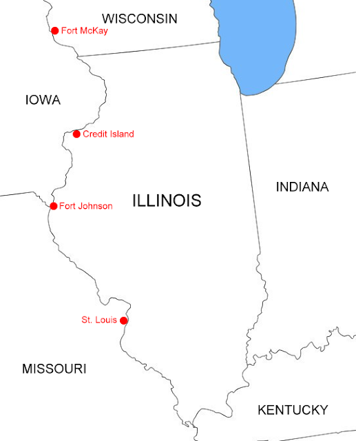
Upper Mississippi Valley, September 1814, with locations mentioned in the text.
While there is some debate as to the number of soldiers originally with Taylor on his Credit Island expedition and therefore initially present at Fort Johnson, citing the September 3, 1814, edition of The Missouri Gazette, states that Taylor was accompanied by 430 militia and rangers. The newspaper article actually reads “Eight barges containing about 400 rangers and militia left Capeau Gray on the 22nd.” In October 1814, other newspapers were circulating a similar article, which reported that “the Major’s command consisted of about 400 men, including regulars, rangers, and militia.” Taylor, however, in his September 6, 1814, account of the battle, recorded that the American forces consisted of “334 effective men, officers, non-commissioned officers and privates.” Taylor’s use of the word “effective,” in addition to referencing the number of men available to fight, may also imply that there could have been nonmilitary personnel associated with his Credit Island expedition. In any case, as Taylor should have known the number of men in his command, 334 is believed to be the number of Americans taking part in the Credit Island battle. Of this total, 40 soldiers belonged to the 7th Regiment of Infantry. Taylor, perhaps in an attempt to vindicate himself regarding what would be his only military defeat, later wrote that his force of men was “principally” of the militia. This statement is generally corroborated by Callaway, who wrote his wife that there were “about forty five Regular Troops” at the fort during its construction with members of the militia and rangers comprising the remaining men.

Three Americans were killed during the Credit Island battle and eight were seriously wounded. On September 10, 1814, just five days after the battle, a barge with the sick and wounded arrived back in St. Louis. As such, there would have been approximately 323 soldiers initially present at Fort Johnson. 

In a letter dated September 25, 1814, Captain James Callaway wrote his wife that “we have the fort finished” and that he was ordered to remain at the fort with “fifty of my own men and fifty of Capt Whiteside’s company.” He further writes that “we have not more than ten Days of provisions for the troops” and that if provisions “does not reach this place against the last of this month that the post will be evacuated.” Those provisions never reached “this place,” and in October 1814 Callaway dismantled and burned the fort, abandoning the frontier of west-central Illinois and embarking for Fort Cap au Gris (aka: Cape au Gres or Capo Grey) near Troy, Missouri.

While the exact length of time Fort Johnson was occupied is not recorded, a reasonable estimate can be constructed utilizing three primary sources: (1) Captain Callaway’s letters to his wife; (2) the journal of Captain Thomas Anderson, who was the British commander of Fort McKay in Prairie du Chien, Wisconsin, during the fall of 1814; and (3) an October 20, 1814, letter from 7th Regiment and District Commandant Colonel William Russell in St. Louis to Secretary of War James Monroe.

The Battle of Credit Island[2], which was fought near present-day Davenport, Iowa, and from which Taylor’s U.S. forces were retreating, occurred by American accounts on 4–5 September 1814 and by British accounts on 5–6 September of that year. Given that both Taylor and Callaway agree on the dates, the American timeline will be followed herein. In a letter dated September 6, Callaway writes his wife “we are on our return from Rock River and at this place we have to build a fort” indicating that the troops had already arrived at the mouth of the Des Moines River where the fort was to be constructed. As mentioned previously, on September 25 he wrote his wife that the construction of the fort was finished and included a sketched map of the fort, but went on to note that the fort had only 10 days of provisions left, or enough to last until October 5. After that date, if additional supplies were not obtained, Callaway noted that he believed the fort would have to be abandoned. In the same letter, Callaway continued to express hope that the provisions would arrive in time, telling his wife “I expect to be Relieved in twenty or twenty five Days,” which would be approximately October 15–20, 1814. Therefore, based on Callaway’s letters, the troops arrived at the proposed location of the new fort on September 6, with construction completed by September 25. Immediately following, Taylor took most of the men and continued on to St. Louis, leaving Callaway in charge at Fort Johnson. Taylor arrived in St. Louis on October 1, which suggests that he left Fort Johnson around September 29th.

While 20 days may seem like an exceptionally quick time to build a fort, this was evidently not unusual for American forts during the War of 1812. Captain Anderson, describing the construction of Fort Johnson in his 1814 journal, relates, “The forts they build are constructed in such a manner, that three or four hundred men knock up one in the course of three weeks.” This suggests that Brevet Major Taylor was likely at Fort Johnson with his 323 men from at least September 6 through September 25 (i.e., the length of time of fort construction stated in Callaway’s letters), plus a few more days. As previously noted, Taylor then took all but 100 of the men and returned to St. Louis, arriving there on October 1. The population of the fort over the rest of its short existence (about 18 days) was therefore approximately 100 soldiers, with most, if not all, composed of militia and rangers, as opposed to the regular army.

Callaway does not record the exact date of the fort’s abandonment, but it can be reasonably estimated to be within a day or two of that event. In his history of the fort/cantonment, Talbot, appearing to quote directly from Peck (1850), states, “It is reported that in ‘Late October (about the 22nd) of 1814, citizens of St. Louis were astounded to learn that the troops at Fort Johnston [Johnson] had burned the blockhouses, destroyed the works, and retreated down the river to Cap au Gris.’” Peck’s actual sentence, however, reads, “And in the month of October, the people of St. Louis were astounded with the intelligence, that the troops stationed in Fort Johnston, had burnt the block-houses, destroyed the works, and retreated down the river to Cape au Gres.” No mention of a specific abandonment date is listed in Peck’s account, but he was likely referring to the October 22, 1814, edition of The Missouri Gazette, which mentions the arrival of the Fort Johnson troops at Cap au Gris.

Wesley also had earlier championed the October 22 date for the abandonment of Fort Johnson: “The supplies evidently failed to arrive, for the post was evacuated and burned about October 22.” While Wesley also does not cite a source for the October 22 date, he too was likely referring to the October 22, 1814, edition of The Missouri Gazette mentioned above. The Missouri Gazette was a weekly newspaper published on Saturdays, thus October 22 presumably refers to the date of the newspaper’s publication, not the date of the fort’s abandonment.

British Captain Thomas Anderson, writing in his 1814 journal, does provide a somewhat more specific date for the abandonment: “Three Sauk canoes arrived, bearing each a flag. They bring word that the American fort, at the foot of the Riviere des Moines Rapids, was abandoned about the 20th of October. The Americans had burnt the fort, and proceeded to the Illinois.”

An even more precise date of abandonment, however, can be estimated from a letter written from Colonel William Russell on October 20, 1814, to Secretary of War James Monroe: “I have to apprise you, that fort Johnson, recently built by Maj Taylor, up the Mississippi is evacuated, the troops and all the stores, have arrived here on yesterday.” Interestingly, an article relating to the abandonment of Fort Johnson was circulating among newspapers in November 1814. Usually titled “Fort Johnson Evacuated and Burnt” and dated “St. Louis, October 18,” the article begins “A few days ago the troops who were stationed at the new fort, [Johnson at the foot of the Rapids of Lamoin] arrived at Cape aux Grei, having burnt the Block houses and otherwise destroyed the works,” implying that the troops arrived in St. Louis before October 18, 1814. The “few days ago” likely refers, however, to the period immediately prior to the October 22, 1814, publication of The Missouri Gazette, where the article originally appeared, and not the October 18 byline published in the November 1814 papers. As the later articles in all likelihood misrepresented the actual return date of the troops, Russell’s October 20 letter will serve as the primary source regarding the date of their return.

While we now know the date of the troops’ arrival at Fort Cap au Gris, which was October 19, we still don’t know the date of their departure from Fort Johnson. This can be estimated by examining the rate of travel of Taylor’s retreat from Credit Island in 1814, as well as a journal kept by noted U.S. Army explorer and engineer Major Stephen Long in 1817.

Taylor’s troops left Credit Island, which is located at River Mile 480, around noon on September 5, following a 6-hour battle that began at daybreak. Traveling in keelboats, they stopped at least once about 3 miles south of Credit Island to attend to the wounded and repair the boats. They arrived at the Fort Johnson location, which is located approximately at River Mile 360, sometime on September 6. On the same day, both Taylor and Callaway wrote letters detailing the Credit Island battle. Interestingly, Taylor’s letter to General Benjamin Howard is dated “Fort Madison,” which had been burned late in 1813 or approximately one year before the Credit Island battle, while the locational reference in Callaway’s letter is less specific, other than to note that “at this place” the troops are to build a fort. Whether Taylor stopped briefly at the former location of Fort Madison to write his report or was simply referring to Fort Madison as a point of reference while writing his report from the yet unnamed location of Fort Johnson, is unknown. It should be noted that in his letter to General How-ard Taylor does not mention stopping again after repairing the boats; also Fort Madison is located approximately 22 miles upriver from the site of Fort Johnson. Nevertheless, it is apparent that Taylor’s men traveled approximately 120 miles downriver in slightly more than 24 hours, and presumably, the retreating soldiers may also have sailed at night.

Fort Cap au Gris is located approximately at River Mile 240, a distance of 120 miles downriver from Fort Johnson. In 1817, Major Stephen Long left Fort Edwards, which is located approximately one-half mile north of Fort Johnson, at 2:00 p.m. on August 11 in a skiff and “Arrived at Little Cape Gris about dark” on August 13. Long stopped sailing for about 5 hours the night of August 12 due to “an unfavorable wind accompanied by rain” and also stopped at “Burr’s Tavern” early in the morning of August 13. Other than these two layovers, Long appears to have continuously sailed for the two days and nights. Considering the rate of travel downriver by both Taylor and Long, Callaway and his men therefore should have easily made the journey downriver from Fort Johnson to Fort Cap au Gris in two days if they also sailed at night, suggesting they left Fort Johnson on October 17.

A reasonable estimate for the construction, occupation, and abandonment of Fort Johnson is therefore from September 6 through October 17, 1814, or a total of only 42 days.

Black Hawk described the founding of the fort and a skirmish in his Autobiography: Life of Black Hawk as dictated by himself.
"A party of braves followed to watch where they landed, but they did not stop until they got below the Des Moines Rapids, where they came ashore and commenced building a fort. I did not want a fort in our country, as we wished to go down to the Two River country in the fall and hunt, it being our choice hunting ground, and we concluded that if this fort was built, it would prevent us from going there. We arrived in the vicinity in the evening, and encamped on a high bluff for the night. We made no fire, for fear of being observed, and our young men kept watch by turns while others slept. I was very tired, and was soon asleep. The Great Spirit, during my slumber, told me to go down the bluff to a creek, that I would there find a hollow tree cut down, and by looking in at the top of it, I would see a large snake with head erect—to observe the direction he was looking, and I would see the enemy close by and unarmed. In the morning I communicated to my braves what the Great Spirit had said to me, took one of them and went down a ravine that led to the creek. I soon came in sight of the place where they were building the fort, which was on a hill at the opposite side of the creek. I saw a great many men. We crawled cautiously on our hands and knees until we got to the bottom land, then through the grass and weeds until we reached the bank of the creek. Here I found a tree that had been cut down; I looked in at the top of it and saw a large snake, with his head raised, looking across the creek. I raised myself cautiously, and discovered nearly opposite to me, two war chiefs walking arm in arm, without guns. They turned and walked back toward the place where the men were working at the fort. In a little while they returned, walking directly towards the spot where we lay concealed, but did not come so near as before. If they had they would have been killed, for each of us had a good rifle. We crossed the creek and crawled to a cluster of bushes. I again raised myself a little to see if they were coming; but they went into the fort, and by this they saved their lives. 
We recrossed the creek and I returned alone, going up the same ravine I came down. My brave went down the creek, and I, on raising the brow of a hill to the left of the one we came down, could plainly see the men at work. I saw a sentinel walking in the bottom near the mouth of the creek. I watched him attentively, to see if he perceived my companion, who had gone toward him. The sentinel stopped for some time and looked toward where my brave was concealed. He walked first one way and then the other. 
I observed my brave creeping towards him, at last he lay still for a while, not even moving the grass, and as the sentinel turned to walk away, my brave fired and he fell. I looked towards the fort, and saw the whites were in great confusion, running wildly in every direction, some down the steep bank toward a boat. My comrade joined me, we returned to the rest of the party and all hurried back to Rock River, where we arrived in safety at our village. I hung up my medicine bag, put away my rifle and spear, feeling as if I should want them no more, as I had no desire to raise other war parties against the whites unless they gave me provocation. Nothing happened worthy of note until spring, except that the fort below the rapids had been abandoned and burned by the Americans."
Cantonment Davis
One year later, in October 1815, Colonel Robert C. Nicholas and eight companies of infantry, totaling approximately 825 men, along with Colonel Stephen Byrd and an unknown number of his mounted militia, established a winter encampment, christened “Cantonment Davis,” amid the ruins of Fort Johnson. The mission was to erect a new, more permanent fort to the north of Fort Johnson’s former location, as well as to establish additional forts along the upper Mississippi River.

While the exact date of their arrival is unknown, Talbot reports that, based on the military correspondence of that time, the “forces began moving upstream about the 10th or 12th of October toward their appointed objective” and estimates their arrival to be around October 20, 1815. “A number” of the mounted militia, who were employed to drive cattle up the Mississippi River valley to Cantonment Davis, had arrived at and vacated the cantonment prior to October 29, 1815.

In addition to the personnel garrisoned at Cantonment Davis, the facility also served as a staging area for other troops as they moved upriver to establish other military posts. Brevet Brigadier General Thomas A. Smith and an unknown number of men (“part of his command” of 820 officers and men) arrived at the cantonment in April 1816 on their way to establish forts at Rock Island and Prairie du Chien. Smith and his men arrived at Rock Island on May 10, 1816, to construct Fort Armstrong. Newspapers of that time reported, “Gen. Smith with about 1000 regular troops, is erecting a fort on Rock Island.” Smith supervised construction at Rock Island for only a short time, arriving in Prairie du Chien in June 1816 to begin construction of Fort Crawford. 

Cantonment Davis’ primary mission, the construction of what would later be named Fort Edwards, commenced in the late spring of 1816 after Smith’s soldiers had continued on up the Mississippi River. The probable beginning construction date of Fort Edwards is June 1816, based on an excerpt from Major Stephen Long’s 1817 journal: “They [the fort works] have been wholly executed by the soldiery stationed there since June 1816.” As late as August 1817, the construction of Fort Edwards was still not completed.

Based upon the previously cited Stephen Long journal, the remaining Cantonment Davis soldiers likely began living at the site of Fort Edwards in June 1816. Thus, the maximum occupation span for the cantonment is eight months, from the end of October 1815 until sometime in June 1816. The population of the cantonment is more difficult to estimate and fluctuated throughout the life of the camp. From October 1815 until April 1816, however, at least 825 soldiers likely lived there, consisting mainly of regular army troops as opposed to the militia. That number may have nearly doubled in April 1816 when additional troops were staged at this location, with some leaving in late April or early May to construct forts Armstrong and Crawford. Others, such as the 100+ men of Major White Young’s company, may have remained until the construction of Fort Edwards began in June 1816.

Summary
Based upon a review of the available archival resources, the following can be deduced for the occupation spans and populations of Fort Johnson and Cantonment Davis:

1) Construction of Fort Johnson occurred from September 6th to 25th of 1814, carried out by approximately 323 members of the militia, rangers, and regular army. 

2) Around September 29, 1814, Major Taylor took approximately 223 soldiers and arrived in St. Louis on October 1, leaving Captain Callaway in charge of 100 members of the militia and rangers.

3) Callaway abandoned and burned Fort Johnson on October 17, 1814, arriving at Fort Cap au Gris on October 19, 1814.

4) Around October 20, 1815, Colonel Nicholas, with approximately 825 members of the infantry and an unreported number of militia, arrived at the deserted Fort Johnson location and established Cantonment Davis.

5) The militia, whose primary mission was to drive a cattle herd to Cantonment Davis to supply food for the winter, left the camp prior to October 29, 1815.

6) Additional troops under the command of General Smith arrived at Cantonment Davis in April 1816. The arrival of Smith’s men may have nearly doubled the camp’s population.

7) General Smith’s men left the cantonment in late April–early May 1816 to construct Fort Armstrong on Rock Island, eventually arriving at Prairie du Chien in June 1816 to begin construction of Fort Crawford.

8) The remaining cantonment soldiers, approximately 100 men, likely began living at the location of Fort Edwards in June 1816, bringing an end to Cantonment Davis.

Fort Johnson, therefore, had a population of approximately 323 soldiers for 24 days, decreasing to 100 men for the remaining 18 days. While precise dates and population numbers for Cantonment Davis are difficult to determine, at least 825 soldiers were at the camp for a minimum of six months, with a larger number staying there in April 1816. A contingent of around 100 soldiers continued to live at Cantonment Davis between early May 1816 and sometime in June 1816. The maximum total occupation span of the cantonment is therefore eight months. Nonmilitary personnel connected to either the fort or the cantonment could also include sutlers, officers’ wives, and officers’ servants and slaves, as well as washerwomen, nurses, and other camp followers, making the total population of each military post even larger.

Rediscovering Lost History
The initial search for Fort Johnson and Cantonment Davis' footprint began in 1983. More work at the site began again in 2003 targeting several spots before they found the footing of a limestone fireplace. To protect the integrity of the site, the location hasn’t been disclosed to the general public.

Archaeologists speculate that the camp used the foundation of Fort Johnson as a trash receptacle, later covering it with sand to conceal the garbage and level of the area.


Compiled by Dr. Neil Gale, Ph.D.


[1] Cantonment - A camp or military quarters, usually large in size, where people are trained for military service. Also the winter quarters of an army.


[2] The Battle of Credit Island 1814 - Credit Island is an island in the Mississippi River on the southwest side of Davenport, Iowa within the Quad Cities area. The name was derived from the use of the island as an early Indian trading post. Credit could be obtained on the promise of hides and skins to be delivered at a later time - hence Credit Island.

The Battle of Credit Island occurred on September 4th and 5th of 1814, as American troops tried to take control of the Upper Mississippi away from the British and the Sauk Indians. For the Americans, Major Zachary Taylor led a force of more than 350 U.S. regulars and militia in eight gunboats, to relieve Fort Crawford at Prairie du Chien, Wisconsin, and evacuate the fort. The American force hoped to destroy the Indian village and crops on the Rock River, upstream from its confluence with the Mississippi River. When Taylor realized his artillery would not be effective from the gunboats and a large number of Indian warriors present would not permit him to disembark his guns, Taylor decided to feint movement upstream, as if his target was the Prairie du Chien. The Americans had just begun this upstream move on the afternoon of September 4, when a strong storm blowing downstream forced the Americans to stop for the night at Pelican Island. At least two of the American boats had poor anchors, and these boats tied off to the island.

At first light on September 5, a number of Indians had waded to Pelican Island from Credit Island, and an American sentry was shot and killed. The Americans disembarked a force and cleared the Indians from Pelican Island. At about this same time, the few British with a 3-pounder and two swivel guns abandoned their position watching the Rock Island rapids and moved downstream to the western bank of the Mississippi, where they had a clear view of the American boats. 

Taylor had one of his boats drop downstream to cover the channel between Credit and Pelican Islands, to keep the Indians from returning to Pelican Island. Shortly thereafter, the British began an artillery barrage, inflicting serious damage to the American boats. By one account, 51 of the 54 shots hit American boats. The barrage continued for only 45-60 minutes before Taylor recognized the need to retreat from his untenable position. The Americans retreated downstream. The Indian forces and the British were low on ammunition and supplies and did not pursue the Americans.

Mississippi River Boundary Anomalies.

While it might seem logical for the border between Missouri and Illinois to follow the Mississippi River, this has led to some rather peculiar situations. 
Mississippi River Near Galena, Illinois.
The boundary is fixed, but the river is not. The Mississippi River is a dynamic waterway that has shifted its course over time, leaving some portions of land on the opposite side of the river from where they should be according to state boundaries.

sidebar
In geomorphology, avulsion is a sudden and dramatic change in the course of a river or stream. It occurs when the river abandons its existing channel and forms a new one, typically on its floodplain. Avulsions can be caused by a variety of factors, including floods, landslides, and human activities such as dam construction. Avulsions can have a significant impact on the landscape, creating new landforms and destroying existing ones. They can also have a major impact on human settlements and infrastructure. For example, an avulsion can isolate a community from its water source or transportation network.

Below are the seven locations along the Mississippi River affected by an avulsion. 

NORTH TO SOUTH VIA THE MISSISSIPPI
Roughly 110 Miles.
  1. Ste. Genevieve-Modoc Ferry Landing, IL
  2. Kaskaskia Island, IL
  3. Crains Island, IL
  4. Wilkinson Island, IL
  5. Grand Tower Island, IL
  6. Marquette Island, Cape Girardeau Township, MO
  7. Missouri Sister Island, IL
Ste. Genevieve-Modoc Ferry Landing: The ferry crossing north of Ste. Genevieve joins Missouri and Illinois, but only barely. The land immediately north of the Ste. Genevieve-Modoc Ferry landing on the Illinois bank is actually part of Missouri.
Missouri is on the left, and Illinois is on the right.


VIDEO
Hop on, we're going to Ste. Genevieve,
on the Modoc Ferry from Illinois.

Kaskaskia Island: 
The most well-known avulsion was at Kaskaskia Island, where a sizable chunk of Illinois now sits on the Missouri side. Kaskaskia is one of many such oddities, though. Walking across the Missouri-Illinois state line several times without crossing a bridge, riding a boat, or getting your feet wet is possible.
Note: The green area is in Illinois, although it's now on the Missouri side of the  Mississippi and is legally Illinois.
Explore this area via Google Maps.


The town of St. Mary was originally a riverport called St. Mary's Landing. After a flood in the 1880s, the river shifted a few miles east at the opposite side of Kaskaskia Island, leaving St. Mary without any riverfront property (except in 1993). A bridge at St. Mary crosses the old channel, providing the main entrance to this isolated portion of Randolph County, Illinois.

This is the signage along US 61 at the entrance to Kaskaskia Island in St. Mary.
The island does have a second entrance along Cottonwoods Road, a gravel road connecting US 61 with the village of Kaskaskia. The road doesn't cross any bridges -- the old river channel is long gone -- so there's no indication when driving across the state line.
The foreground is Illinois, and Missouri is in the distance; the boundary is unmarked.

Crains Island: 
This sliver of land south of Chester is on the Missouri side of the river and is protected by a Missouri levee but under Illinois laws.
It's hard to tell from my maps, but this post marks the state line in the middle of a field.
The boundary at Crains Island is complicated, shown as "Indefinite" on topographic maps.

Wilkinson Island: 
If you were to launch a boat from Seventy-Six Conservation Area in Perry County, go straight across the river, and dock on the other side, you would technically still be in Missouri. The island was presumably named for John Wilkinson, the founder of the ghost town of Seventy-Six and the only person who could explain how Seventy-Six got its strange name.
The view from the boat ramp at Seventy-Six, looking from Missouri... into Missouri.

Grand Tower Island: 
This former island south of Grand Tower, Illinois, is the largest chunk of Missouri territory on the Illinois side of the river. Driving south from Grand Tower along Levee Road, you go from Illinois to Missouri and back to Illinois without passing a single sign or marker.
Looking north along Levee Road from Missouri into Illinois. The end of the pavement marks the state line.
The old river channel is now a U-shaped lake called Tower Island Chute. It still looks like a river but is cut off by a levee from the modern river channel.

Marquette Island: 
This 835-acre island (a sand bar) is part of Missouri just south of downtown Cape Girardeau, connected to the Illinois shore when the river is low. 

Missouri Sister Island: 
The name is an oxymoron: it's not an island, and it's not in Missouri. Sitting inside a sweeping 'S' bend of the river northwest of Cairo, this piece of Illinois has found itself on the Missouri side. Thanks to the crazy geography, the river flows to the northwest here -- and Missouri is east of Illinois. Yes, it's all somewhat confusing.

Compiled by Dr. Neil Gale, Ph.D. 

Sunday, October 14, 2018

The History of Fort Edwards in Warsaw, Illinois. (1814-1824)

The City of Warsaw, which sits on the east bank of the Mississippi River across from Alexandria, Mo., and south of the Mississippi’s confluence with the Des Moines River, got its start around 1812, an outgrowth of two forts, Fort Johnson was 1/2 mile south of Fort Edwards and the settlement they fostered. 
Fort Johnson and Fort Edwards were built on the east side of the Mississippi River as counters to a British military installation about 100 miles north and part of about 94 forts in today's Illinois footprint.

There are letters from William Henry Harrison Sr., the 9th President of the United States, dated 1807 requiring all settlements to have a small fort or blockhouse constructed.
The Fort was abandoned in 1824. There are no remains of Fort Edwards.

In addition to soldiers posted in the area by 1814, Indians from the Sauk and Iowa tribes settled near the fort and had started to raise corn. Fort Edwards was built in 1814 on the northernmost bluff and named for Ninian Edwards, the first Illinois governor. The purpose of the log-constructed fort was to protect the movement of supplies on the Mississippi River. 

The fort was leased to the American Fur Company from 1828 to 1832 and served as a fur trading post for more than a decade.

Members of the Mesquakie (Fox) tribe were scattered along the Mississippi from Prairie du Chien, Wisconsin, to Fort Edwards by 1822. Early Warsaw residents Maj. John R. Wilcox, Mark Aldrich, John Montague, and John Vineyard platted the city in 1834.

Major Wilcox had been stationed at Fort Edwards in 1822. He left for a short time after the fort was abandoned in 1824, then returned to live in the area. He built a log cabin in 1827 near the Mississippi River just below the original site of Fort Johnson. His home is believed to be “the first house in what was later to become the town of Warsaw.” Nine years later, Wilcox started a ferry that enabled the movement of people and commodities across the Mississippi from Warsaw to Alexandria and vice versa.

Mark Aldrich arrived in Warsaw in 1832, building the second house in the town – a two-story log home. Despite a brief time of upheaval during the Black Hawk War in 1832, Warsaw grew until there were about 24 inhabitants in 1834.

In the 1840s the Mississippi River opened up to passenger boats filled with “thousands… among them many emigrants, some from Ireland, others from Germany and France.”

Warsaw became a town in 1839 and a city in 1853.

Many people settled in Warsaw during that time, and commerce began to bloom: “… three distilleries, a tobacco factory, flour mills, brickyards, scores of cooperage shops. In 1845, the little town was claiming a population of 473 by 1850.” The French immigration began in the late 1850s and continued through the ’60s and ’70s. Many of the French people settled in Warsaw in the country extending from Warsaw to Basco.”

In 1855, a brick foundry was built on North Fourth Street where the brewery road turns east. Two years later, 20,000 bushels of grain were delivered to Warsaw for use by its three distilleries and three flour mills. Thousands of barrels were made yearly for the shipment of lard, meat, apples, cider flour, whiskey, and wine.

William Grover, Esq., of Warsaw in 1871 spoke to the Pioneer’s Association, describing Hancock County, Illinois, on a trip he made from Carthage, Illinois, to Warsaw in 1837:

"When the Black Hawk war broke out, the population of the county was still very small and thinly scattered and many settlers left the county for a while. There were no actual depredations here by the Indians but there was, perhaps, just reason for apprehensions of danger. Fort Edwards was then standing upon that point, within 100 yards of this square. It had been abandoned some years before as a military post, but the buildings were then in possession of Col. Farnham, an agent of the government, and by his permission, a number of men and a few families took shelter and protected themselves, if necessary. Among these were Col. Farnham, Mark Aldrich and his wife, Isham Cochrane and his wife and James Wells. Among them was an Indian woman who was married to a white man and it is stated that she stood in more fear of an attack from Indians than any of the pale-faced women at the Fort.

I have a distinct recollection of the appearance of the county from Carthage to Warsaw in 1837,” he said. “Coming west from Carthage, the first house was then owned by William A. Patterson. The next was the Chapman's place. The next places… were the farms of Benjamin Marsh and Gotham Clark, side by side. This brought us to the edge of what was then generally called 'The Warsaw Timber.' From thence to Warsaw we passed Truman Hosford’s cabin, Bartholomew Slattery’s vineyard farm (now part of Warsaw), and Mark Aldrich’s cabin, and from thence down a winding road through small timber and hazel brush to Andrew Monroe’s. At this point, we got up on Main Street and passed a little frame building they used as a meeting house, and three other one-story frame houses of a single room each, on the south side of the street, one used by James Chittenden as a saddler shop, one by Samuel Brown and Wm. Mcllhenny, as a tailor shop, one by Smith Robbins, as a sort of fancy grocery. ("Grocery" had a different meaning than today's grocery stores, which was called a General Store.)

On the other side of the street was a two-story frame house, unfinished, by R.L. Robertson. This brought us to the ‘Warsaw House’ then kept by ‘Old Man Newberry’ as the boarders irreverently called him, and here I slept my first night in a house after five months of railroad exploration.

I do not think there were then in all our large prairies a hundred improvements a mile distant from the timberline. The few roads across the prairies followed the most favorable ground for settlement, regardless of section lines; and in some directions, you might travel for hours without seeing a house or enclosure. If the direction of the beaten road did not suit you, you had full liberty of taking short and direct cuts to your journey’s end."

Today’s Ralston Park in Warsaw, Illinois was the area behind the fort’s stockade and near the fort’s parade ground.

Fort Edwards State Memorial, Warsaw, Illinois.
Today, the forts are gone, but a monument honoring Fort Edwards was built in 1914 on the fort’s site and still stands.
This obelisk known as Fort Edwards State Memorial stands on this promontory overlooking the Mississippi river as a monument to Fort Edwards.
Why does this brass plaque show the wrong build date instead of the correct date of 1816? In 1914, a 50-foot tall monument was erected at the former Fort Edwards location, known as “The Point.” The dedication was thought to be on the 100-year anniversary of the founding of Fort Edwards, however, the monument was built in the wrong year to celebrate Fort Edwards. At that time, the date Fort Edwards was built was not so clear because most of the military documents had been misplaced or lost to fire. The date they chose was later proven historically inaccurate. 1814 was the year that Fort Johnson was built, which was 1/2 mile to the south of Fort Edwards. Fort Edwards was built in 1816.

Compiled by Dr. Neil Gale, Ph.D

The 1918-1919 Influenza Pandemic and its effect on Chicago.

From its start as a marshy portage for Indians and French trappers and traders, Chicago grew to a bustling city of 2.7 million by the time influenza arrived on September 8, 1918, when few sailors at the nearby Great Lakes Naval Training Station fell ill with the disease. A week later, seven army cadets from the Northwestern University SATC unit came down with influenza. Then, a few days after that, cases developed among cadets at the Lewis Institute SATC unit on South Hoyne Street in Chicago itself. The epidemic had begun... and was spreading.
Inspecting Chicago street cleaners for Spanish influenza. Officials are wearing gauze masks. 1918
Military officials acted quickly in an attempt to contain the disease. At Great Lakes Naval Training Station, officers instituted isolation and quarantine controls, ordered all 50,000 sailors to be given daily nose and throat sprays (where, presumably, they could also be quickly examined for symptoms), placed 1,000 men in isolation when they developed symptoms and an additional 4,000 sailors under quarantine for suspect contact with the ill, and cancelled all liberty leave for enlisted sailors until the epidemic had passed. Surprisingly, although sailors were prohibited from leaving Great Lakes station, civilians were still permitted to visit.

By late-September, it appeared that the epidemic at Great Lakes station had crested. Station health officers were happy to report that the number of new cases was decreasing at a rate of approximately 10% per day. In Chicago, Health Commissioner Dr. John Dill Robertson announced that officials had “the Spanish influenza situation well in hand now.” To monitor the situation, Robertson made influenza a reportable disease on September 16, but took no further action.

Chicago’s epidemic, however, had only just begun. On September 21, city health officials took note of a sudden marked rise in the number of deaths due to acute respiratory diseases. By September 30, there were 260 cases in the city. The large and sudden jump in new cases led Health Commissioner Robertson to order the immediate isolation at Cook County Hospital of all known cases. Realizing that hospital isolation would soon become impossible, he told residents to prepare to isolate themselves should they become sick. “Every victim of the disease is commanded to go to his home and stay there,” he announced. “No visitors are to be allowed.”

Robertson was hesitant to implement any further epidemic control measures that might disrupt life or lower morale, and he therefore moved in a slow, step-wise fashion. A survey of the city’s schools showed that Chicago children had thus far managed to escape the brunt of the epidemic, and attendance was still nearly normal despite excluding all students with cold or flu-like symptoms. Schools were therefore to remain open. Robertson and representatives of the city’s various child welfare agencies and organizations believed that children were better off in schools anyway, where they were under watch and kept from roaming the streets.
Despite his hesitation, Health Commissioner Robertson did ask Chief of Police John Alcock to have his officers stop all persistent sneezers and coughers who did not cover their faces with handkerchiefs. Those violators who promised to obey instructions in the future would be let go, but anyone who gave the officer a difficult time would be arrested, given a lecture on the dangers of influenza, and sent before a judge for arraignment. Robertson also warned theater managers and owners to ensure patrons used handkerchiefs or he would shut down their establishments. Churches, schools, theaters, restaurants, streetcars, and other places where people congregated were ordered to maintain proper ventilation. For the time being, these were the extent of Chicago’s control measures. Both Robertson and the Illinois Influenza Advisory Commission agreed that no closure order should be issued, arguing that the epidemic was “practically at a standstill” in Chicago and the northern part of the state.
Chicago may not have needed a public gathering ban yet, but it did need more nurses. On October 11, the Chicago chapter of the American Red Cross issued an urgent call for volunteers. Highlighting the plight of the city’s ill and playing on the heartstrings of women across the region, the Red Cross printed the story of a nurse who made a house call expecting to find a sick mother. Instead, she discovered that the entire family was stricken with influenza: the mother and two young children were all bedridden with high fevers, a 10-month old baby was starving, and the father was wandering the streets in fevered delirium, desperately trying to find a physician to care for his family. “This case,” the Red Cross coordinator wrote, “tells its own story and makes its own appeal to the womanhood of Chicago.” The city’s settlement houses likewise called for volunteers. Some turned themselves over entirely to the epidemic cause. The University of Chicago Settlement House, for example, stopped all its regular activities for several weeks during the epidemic in order to host an emergency hospital and diet kitchen, the latter serving a total of approximately 3,000 meals.

Perhaps because of the increasing occurrence of news such as this, the Illinois Influenza Advisory Commission slowly began changing its tune. The first steps it took were to pass a binding resolution on October 11 banning public dancing in all clubs, cabarets, and halls and to prohibit all public funerals across the state. The Commission reasoned that public dancing was a particularly efficient way both to transmit and contract influenza because of the close contact between dancers and the chilling of sweaty bodies that usually followed a rigorous dance. Receiving the news the next day, Health Officer Robertson notified Chief of Police John Alcock of the ruling and requested that officers stop all dances across the city starting that night – the first night in nearly 16 years that Chicago did not have a weekday public dance. 

On October 12, the Commission recommended that Chicago’s transit company keep streetcar front doors open to ensure a constant stream of fresh air into the cars. The only large gathering that was permitted in Chicago was the WWI military parade held on this day. The Commission realized there was little they could do at this late date to try to stop the event. The best that could be done was to warn parade-goers to take precautions. The Chicago health department gave very specific instructions to those attending. They were to strip, scrub their body’s areas with soap and take a laxative when they got home to prevent catching the deadly flu virus. The parade path ran south on Michigan avenue beginning from the Art Institute. Over a million spectators showed up. It resulted in an increase in the number of new influenza cases.
By now, Chicago physicians were reporting a staggering number of new cases, reaching as high as 1,200 a day and climbing. The Illinois Influenza Advisory Commission, with Health Commissioner Robertson fully participating, now had little choice but to contemplate seriously the closure of public places. On October 14, the Commission invited representatives from professional organizations, the Red Cross, clubs and trade organizations, federal and state officials, and the Liberty Loan committee to meet at the upscale Hotel Sherman, a well known night spot for celebrities, jazz musicians, and Chicago’s high society set, to discuss the possibility of issuing a general closure order. As Robertson put it, “We wish to take no rash action, and desire to be sure that whatever we do will be for the benefit of the city.”

After hearing from constituents, the Advisory Commission handed down its final decision: beginning on Tuesday October 15, all theaters, movie houses, and night schools were to close immediately for an indefinite period, and all lodge meetings and other similar gatherings were prohibited. The Commission included “all other places of public amusement” in its order, but acknowledged that further clarification was needed in order to determine the exact extent of the phrase. Churches were left off the list for the time being, since no religious services would be held for at least three more days. In the end, Chicago churches were not required to close, although clergy were asked to keep services short and their buildings well ventilated. An unintended but salutary effect was that many churches organized parishioners into soup brigades to help families stricken by influenza. At a time when charity and volunteer work was practically the only safety net, churches and synagogues were major centers and organizers of aid, and many did their best to alleviate as much of the ancillary suffering as they could.

Movie houses and theaters were the prime focus, as they were seen as the places most likely to cause the spread of influenza. Public schools were to remain open because of well-organized systems of medical inspection already in place. In fact, school health officers and nurses were instructed to drop all their routine work and concentrate solely on student inspections. Closing schools may have mattered little by this late date anyway, as absentee rates had already reached as high as thirty percent, and would spike to nearly fifty percent within a week. Not all of these absences were due to illness; some were the result of worried parents. Others were due to mischievous students who took to sniffing pepper in order to induce a coughing or sneezing fit, knowing that they would be sent home for a week.

On one horrible October day 381 people died from influenza in Chicago. Considering how badly Chicago was hit in October, it turns out to be a blessing that the World Series (Cubs versus the Red Sox) was held a month earlier because of the War. The Cubs-Red Sox World Series of 1918 remains the only World Series in history to be held in September. The President of the United States (Woodrow Wilson) had ordered the season ended on September 1st, so that any and all able men would work for the war cause and/or enter the military. He had no way of knowing it when he made that order, but it probably saved lives in Chicago and Boston. Having huge crowds come out for something like this only would have helped the influenza spread more quickly. Baseball was still affected by loss. The Boston Braves outfielder Larry Chappell died in San Francisco. Former St. Louis Browns outfielder Emmet Heidrick died in Pennsylvania. Former Pirates and Reds outfielder Jake Stenzel died in Cincinnati (he had started his career with the Cubs, but played only a handful of games for them many years earlier). American League umpire Silk O’Loughin also perished in the pandemic. As did former Tigers owner William Yawkey.

CHICAGO WAS CLOSED!
Despite the grumblings of some residents, the closure order had the desired effect. Chicago’s loop district, home to most of the city’s entertainment district, was suddenly empty at night. Newspapers reported that the sidewalks were clear, the restaurants half deserted, and the taxicabs idle. Health Commissioner Robertson was pleased with the news. Theater and movie house owners and employees, naturally, were not. Estimates as to the financial losses they would suffer varied greatly, but it was generally agreed that approximately 650 theater workers and an additional 500 movie house employees were now out of work. Lost box office receipts were difficult to ascertain, but at least one theater had already sold $80,000 in advance tickets for just a single performance. Workers were especially hard hit. “Unfortunate now are these comely young women of the chorus,” one newspaper columnist wrote of the theater closures, “for their misfortune is not their fault. It is not to preserve their health but our health that they bravely forgot their right to earn bread and rest.”
Posters like this one were posted around Chicago and at most public venues.
More businesses were about to be affected. On October 15, the Illinois Influenza Advisory Commission met to try to decide what other places of public amusement and gathering should be closed. No definite consensus could be reached, although the group did agree that ice skating rinks would be added to the list. The next day the Commission members finally concluded that all non-essential public gatherings should be banned, but that actual implementation of the recommendation should be left up to State Health Commissioner C. St. Claire Drake and local authorities. Drake immediately issued the recommendation as a statewide order, decreeing that all public gatherings of a social nature and not essential to the war effort be discontinued indefinitely. All banquets and public dinners, conventions, lectures and debates, club and society meetings, union gatherings, and athletic contests (whether indoor or out) were therefore prohibited. Saloons could remain open, as could poolrooms and bowling alleys, so long as they were properly ventilated. All other forms of gathering not expressly prohibited by the state order could continue, so long as spitters, coughers, and sneezers were kept out and crowding was not permitted. Both Illinois and Chicago officials continued to enact epidemic control measures in a stepwise manner.

During the epidemic, “Fresh Air Cars” were introduced on the elevated train systems. These were 'L' cars with the windows locked open to maximize air circulation. One sign said: “Get the fresh air habit. Dress warm enough to enjoy it.” Another sign said: “Too much fresh air is just enough.” The idea the fresh Lakefront air promoted health was widespread, especially at a time when the rest of Chicago’s air was horrendous. A result of this "Fresh Air" concept was the opening of the "Chicago Daily News Fresh Air Fund Sanitarium" in 1920.
Makeshift Hospital Ward during the 1918 Epidemic.
The epidemic raged. Sad stories of influenza-stricken Chicagoans filled the pages of the city’s newspapers: Phyllis Padula and her four young children suffering from bad cases of influenza when her husband Angelo ventured out in search of a physician, only to commit suicide by jumping into the frigid Chicago River; a Spanish-American War veteran, armed with a shotgun and two revolvers and delirious with fever, in a two-hour standoff with police; a wife suffering a mental breakdown after caring for her sick husband and five children, dousing her family’s clothing in gasoline and setting the pile ablaze as they all shivered in the cold. In another case, Peter Marazzo killed his wife and four children by slitting their throats. Brought to trial, the jury found him not guilty by reason of insanity due to his high fever brought on by influenza. An army doctor at the trial testified that the toxins from the influenza germ had “lodged in the brain cells and wrecked Marazzo’s mind.” Several physicians at the time observed that various psychoses, most notably dementia praecox (schizophrenia), seemed to develop shortly after bouts with influenza.

By the last days of October, new case reports indicated that the epidemic might be on the decline across Illinois. The Illinois Influenza Advisory Commission hesitated to recommend lifting the closure order and gather ban just yet, though, preferring to hear from local authorities as to the precise conditions in the communities. In Chicago, Health Commissioner Robertson was hopeful that the epidemic would soon be over, but believed that the control measures be kept in place for a short while longer. In the meantime, he suggested that everyone curtail his or her usual Saturday night revelry, go to bed early, and get plenty of rest on Sunday. To many, it sounded far too much like a dose of parenting.

Whether or not Chicagoans followed his advice, by Monday, October 28 the case tallies had declined enough to warrant serious consideration of removing the bans. Robertson and the Health Department drafted a tentative plan that called for the step-by-step and district-by-district return to normal city life over the course of a week. The next day, Tuesday the 29th, after gaining Drake’s approval, Robertson and the Chicago Health Department put the plan into action. Beginning that day, all music and entertainment could resume in the city’s restaurants, cafes, and hotels. On Wednesday the 30th, theaters and movie houses between Howard and Diversey Parkway could re-open. The following day, theaters and movie houses between Diversey Parkway and 12th Street could resume their hours. On Friday, November 1, the rest of the city could re-open. Public meetings were to follow a similar schedule starting on Thursday, with all meetings allowed in all parts of the city by Saturday, November 2. Theaters had to pass inspection before they could re-open their doors, coughers and sneezers were prohibited from entering, no crowding would be allowed, and all public places were required to close by 10 pm. Public dances could resume on Monday, November 4. The reason for the geographically staged schedule was simple: by the fourth week of the epidemic, the greatest number of new cases had occurred in the half of the city south of 12th Street, and Robertson believed that area needed a few more days before it was firmly in the clear.

Conditions in Chicago continued to improve even as residents mixed and mingled in theaters, movie houses, cabarets, and restaurants. In most cities, the removal of social distancing measures was met with a great deal of joy. In Chicago, it was met with some grumbling, aimed primarily at Health Commissioner Robertson. During the epidemic, Robertson had banned smoking on all streetcars, elevated trains, and suburban light rail lines. Now that the danger had passed, however, Robertson refused to remove the no-smoking ban. Reporting on the news, the Chicago Tribune referred to Robertson as “his highness.” On November 2, Robertson ruled that city entertainment venues could remain open until 10:30 pm, adding an extra half hour to Chicago’s nightlife. Robertson advised that all revelers therefore get an extra half hour sleep on Sunday morning in return. The Tribune quickly attacked him for his paternalism, referring to him as “his eminence” repeatedly. “Chicago may disport itself tonight into the late hour of 10:30 by virtue of the gracious order of Dr. John Dill Robertson, city health commissioner,” wrote the Tribune. The following day, when the last remaining flu bans were about to be removed, the Tribune continued its attack on Robertson. “Outside of the fact that you mustn’t cough, sneeze, expectorate or osculate, mustn’t smoke on street cars or in the elevated trains, can not visit sick friends and must continue to observe the food and fuel regulations and keep up your installment payments on Liberty bonds, you can get up tomorrow and do as you darn please,” the article began. Those who wished to attend one of the long-suspended public dances could glide across the floor “without fearing the intrusion of a health department chaperon with untimely remarks about the dangers of proximity.” The editorial staff of the Tribune, and likely many other residents, had thoroughly tired of Robertson’s restrictions and paternalism, especially when they had been placed on top of the already onerous wartime social restrictions and civic responsibilities.

THE OUTCOME
Between the start of Chicago’s epidemic on September 21 and the removal of restrictions on November 16, the Windy City experienced a staggering 38,000 cases of influenza and over 13,000 cases of pneumonia. The white population of the city experienced an increase in deaths of 2,610 percent over the previous year. The African American population, on the other hand, experienced an increase of only 1,400 percent. Health Commissioner Roberston attributed the difference to the intrinsic immunity to influenza and pneumonia among the city’s African American population. In reality, the discrepancy was likely due to racial disparities in Chicago’s health care and access: African American Chicagoans were already much more likely to die of disease than their white counterparts. Epidemic influenza, a disease that did not respect color or socioeconomic lines, therefore only appeared to attack whites with more virulence.

Doctors and nurses worked around the clock during the crisis. Morris Fishbein, a prominent Chicago doctor and later editor of the Journal of the American Medical Association, wrote in his memoirs that most Chicago physicians visited some sixty to ninety patients each day during the height of the epidemic, unable to do much besides try to make them comfortable. Yet, despite these staggering numbers, Chicago actually did fairly well for a city of its size. In fact, with a population of 2.7 million, Chicago’s epidemic death rate for the period was only 373 out of 100,000, not much worse than much touted (and its long-time rival) St. Louis.

Chicago’s epidemic experience led to important changes in the city’s medical care infrastructure. In January 1919, with the main danger over, Health Commissioner Robertson turned his attention to correcting some of the shortcomings the city experienced during the crisis. Highest on his list was the nursing shortage. In 1907, after several failed attempts, the Illinois legislature had passed a law creating a board to register trained nurses after two years of schooling. At the time, Robertson opposed the bill, arguing that it would drive up the cost of nurses and create a system whereby those of only modest means would not be able to afford adequate care. “The nurse has become a necessity in our present civilization,” he argued, “but her cost has made her services a luxury that only those in good circumstances can enjoy.” He believed that any woman (and, following the sexism of the times, he considered women as natural nurses due to their innate ability to follow a man’s orders) with intensive training could be made a competent nurse in a matter of three to six months, not two or three years. If the army could churn out perfectly good officers in three months, he argued, good nurse educators should be able to do the same. Now, in the wake of the epidemic, Robertson felt an even greater sense of urgency in bolstering Chicago’s nursing corps.

To create a large contingent of these “practical nurses” as he called them, Health Commissioner Robertson suggested several changes. First, hospitals should immediately modify their curricula so that two classes of nurses could be trained. One track would become registered nurses, while the other would take six months of intensive training. Second, the state legislature should change current nursing law to allow for the training of these practical nurses as well as lower the number of years required of registered nurses from three to two. Lastly, Robertson suggested that if Illinois lawmakers did not act, then Chicago should take the lead in licensing practical nurses much the same way as it licensed undertakers.

His ideas were welcomed by some and angrily dismissed by others. Within a week of announcing the idea, the city’s Director of the Department of Education and Registration had already drafted a bill allowing for a one-year course of training for practical nurses, which he said he was prepared to present to the state legislature. A group of supportive physicians offered to travel to Springfield to support the bill if necessary. The Journal of the American Medical Association endorsed the idea of a separate track of practical nurses in an editorial blaming trained nurses for the current woes. A nurse should be “a true physician’s assistant and will be a household helper not too proud to assist in the kitchen or even to help care for the baby,” the editor wrote.

On February 18, 1919, the new nursing bill was introduced in the Illinois General Assembly. The bill provided for a one-year course of training for practical nurses, granted authority to the State Board of Registration to license those who passed the training, and made it illegal to pose as a registered nurse unless entitled to do so. Hospitals, which would benefit from the lower cost of practical nurses, supported the bill. Registered nurses, who stood to lose some control over their profession and who feared a decrease in their wages, naturally opposed it. In the end, the support for the proposal was simply too strong for nurses’ groups to withstand. The bill passed.

On July 21, 1919, Chicago’s Training School for Home and Public Health Nursing opened its doors. Nearly 800 women completed the inaugural class, and within two years some 3,000 women had passed the course. When influenza returned in 1920, 600 of these graduates answered the call for volunteers, exactly as Health Commissioner Robertson had hoped they would.

The program worked so well that Robertson instituted a second similar program in connection with the Municipal Tuberculosis Sanitarium in 1920. Never again would Chicago be faced with a critical shortage of nurses during a time of need.

In the two years that this flu ravaged the earth, a fifth of the world’s population was infected. It infected 28% of all Americans. An estimated 675,000 Americans died of influenza during the pandemic. 117465 Americans died in the WWI.

Compiled by Neil Gale, Ph.D. 

Saturday, October 13, 2018

The History of Fort Russell in Edwardsville, Illinois. (1812-1815)

The approximate location of Fort Russell is known, but even after years of intense searching the exact location is unknown — and we may never find out. A Government Land Office survey gives the general location, northwest of Edwardsville along what was then called the "Edwards Trace," now Springfield Road, which itself was a route used by Indians for hundreds of years.
CLICK FOR A FULL SIZE VIEW
The killings by Indians in 1812 of a settler near what is now the Village of Pochahontas, Illinois and another in present-day lower Alton led territorial Gov. Ninian Edwards to order the construction of a series of blockhouses — two-story, windowless buildings where pioneers could take refuge — at 20-mile intervals between the Mississippi and Kaskaskia Rivers.

Here is what's known. In early June of 1812, the U.S. declared war on England, launching the War of 1812 during the time that France and England were locked in a bitter conflict. The British were doing everything they could to keep America from trading with their cross-channel French enemy. As part of their campaign, England took seamen from U.S. merchant ships and made them serve in the British Navy. England began arming the Indians to help stir up trouble against Americans moving west and encroaching on more Indian land.

Soon after war was declared, Ninian Edwards realized settlers here needed a fortification to protect them from potential attacks. Edwards had been born to a family of wealthy tobacco farmers in Maryland and studied law in Kentucky, where he became the chief justice of the state’s court of appeals. Then, in 1809, President James Madison appointed him governor of the Illinois Territory, which in those days also included Wisconsin and parts of Minnesota and Michigan as well.

Edwards ordered the construction of a fort, which he named for Gen. William Russell, son of a prominent colonel in the Revolutionary War and a fighter himself in the War for Independence in the summer of 1812. 
This model of Fort Russell was made in 1925 by boys of the Manual Training Department at Wood River Elementary schools. It’s now in the basement of Madison County Historical Museum.
But this was not just any fort for Edwards. Once it was built, he reportedly used it as his personal headquarters. Described in one book as a five-gun stockaded blockhouse, it also served as the main supply depot for the territorial militia. John Reynolds, who would become Illinois’ fourth governor in 1830, described it like this in his autobiography, “My Life and Times.”:
“This fort was not only the seat of military operations, but was also the resort of the talent and fashion of the day,” wrote Reynolds, who served as an Army Ranger at the fort. “The governor opened his court here and presided with the character that genius and talent always bestow on the person possessing them."
Fort Russell was 150 square feet on one-half acre. It was defended with five King Louis XIV cannons from Fort de Chartres, a former French outpost. (One of the cannon exploded during use; the others were later sold for scrap.)

It was one of at least 94 forts and blockhouses in the southern part of the Illinois Territory. Most were small places for settlers to take refuge when threatened, but Fort Russell was different. It was the largest and best-equipped fort in all of Illinois. People don't realize that there was not much north of Edwardsville during this time period, so this fort was crucial.

Russell himself had found out how high the stakes could be. In 1773 he had seen his brother Henry captured and tortured to death after an attack by Indians during Britain’s first attempt to establish a permanent settlement in Kentucky. By the 1800s, he was overseeing 10 companies of Army Rangers defending the Western frontier. Fortunately, records seem to indicate that Fort Russell saw no hostilities. Instead, it was used to store munitions and to launch raids into northern Illinois.

Ninian Edwards and 400 mounted troops marched north out of Fort Russell on October 18, 1812, to burn two Kickapoo villages on the Saline Fork of the Sangamon River. In a 13-day campaign, they also reached Peoria to attack villages of the Kickapoo, Miami, and Potawatomi, capturing 80 horses and a few French settlers who were thought to be Indian sympathizers. The following year, an army of nearly 1,400 would repeat the journey. While there were no battles this time, it kept the Indians from massing.

After the war ended in early 1815, the fort was abandoned. As a result, it deteriorated rapidly and was razed by fire in 1837.

Which leaves the ongoing mystery: Where exactly was it? The best guess comes from a 1941 aerial photograph of the Edwardsville area, which may show an outline of such a site about a mile northwest of Edwardsville on Springfield Drive just east of Illinois 159 (Section 34, Township 5-8). It’s a secret that may never be unlocked.
The Marker Reads: One quarter-mile to the west stood Fort Russell, a wooden stockade which served as a base of supplies and operations for the Illinois Militia during the War of 1812. From here, for months at a time, Governor Ninian Edwards administered the affairs of Illinois Territory.

The Marker has been reported missing. The Marker was near Edwardsville, Illinois, in Madison County and could be reached from Springfield Road just east of IL Rt. 159.
“Things that have happened in intervening years might have destroyed any trace of the fort,” according to Greg Vogel, an anthropology professor at Southern Illinois University Edwardsville. “Even if the fort had been there, we might not be able to demonstrate conclusively that it was.”

Compiled by Neil Gale, Ph.D.