
 |
| CLICK FOR A FULL SIZE VIEW |
Here is what's known. In early June of 1812, the U.S. declared war on England, launching the War of 1812 during the time that France and England were locked in a bitter conflict. The British were doing everything they could to keep America from trading with their cross-channel French enemy. As part of their campaign, England took seamen from U.S. merchant ships and made them serve in the British Navy. England began arming the Indians to help stir up trouble against Americans moving west and encroaching on more Indian land.
Soon after war was declared, Ninian Edwards realized settlers here needed a fortification to protect them from potential attacks. Edwards had been born to a family of wealthy tobacco farmers in Maryland and studied law in Kentucky, where he became the chief justice of the state’s court of appeals. Then, in 1809, President James Madison appointed him governor of the Illinois Territory, which in those days also included Wisconsin and parts of Minnesota and Michigan as well.
Edwards ordered the construction of a fort, which he named for Gen. William Russell, son of a prominent colonel in the Revolutionary War and a fighter himself in the War for Independence in the summer of 1812.
 |
| This model of Fort Russell was made in 1925 by boys of the Manual Training Department at Wood River Elementary schools. It’s now in the basement of Madison County Historical Museum. |
“This fort was not only the seat of military operations, but was also the resort of the talent and fashion of the day,” wrote Reynolds, who served as an Army Ranger at the fort. “The governor opened his court here and presided with the character that genius and talent always bestow on the person possessing them."Fort Russell was 150 square feet on one-half acre. It was defended with five King Louis XIV cannons from Fort de Chartres, a former French outpost. (One of the cannon exploded during use; the others were later sold for scrap.)
It was one of at least 94 forts and blockhouses in the southern part of the Illinois Territory. Most were small places for settlers to take refuge when threatened, but Fort Russell was different. It was the largest and best-equipped fort in all of Illinois. People don't realize that there was not much north of Edwardsville during this time period, so this fort was crucial.
Russell himself had found out how high the stakes could be. In 1773 he had seen his brother Henry captured and tortured to death after an attack by Indians during Britain’s first attempt to establish a permanent settlement in Kentucky. By the 1800s, he was overseeing 10 companies of Army Rangers defending the Western frontier. Fortunately, records seem to indicate that Fort Russell saw no hostilities. Instead, it was used to store munitions and to launch raids into northern Illinois.
Ninian Edwards and 400 mounted troops marched north out of Fort Russell on October 18, 1812, to burn two Kickapoo villages on the Saline Fork of the Sangamon River. In a 13-day campaign, they also reached Peoria to attack villages of the Kickapoo, Miami, and Potawatomi, capturing 80 horses and a few French settlers who were thought to be Indian sympathizers. The following year, an army of nearly 1,400 would repeat the journey. While there were no battles this time, it kept the Indians from massing.
After the war ended in early 1815, the fort was abandoned. As a result, it deteriorated rapidly and was razed by fire in 1837.
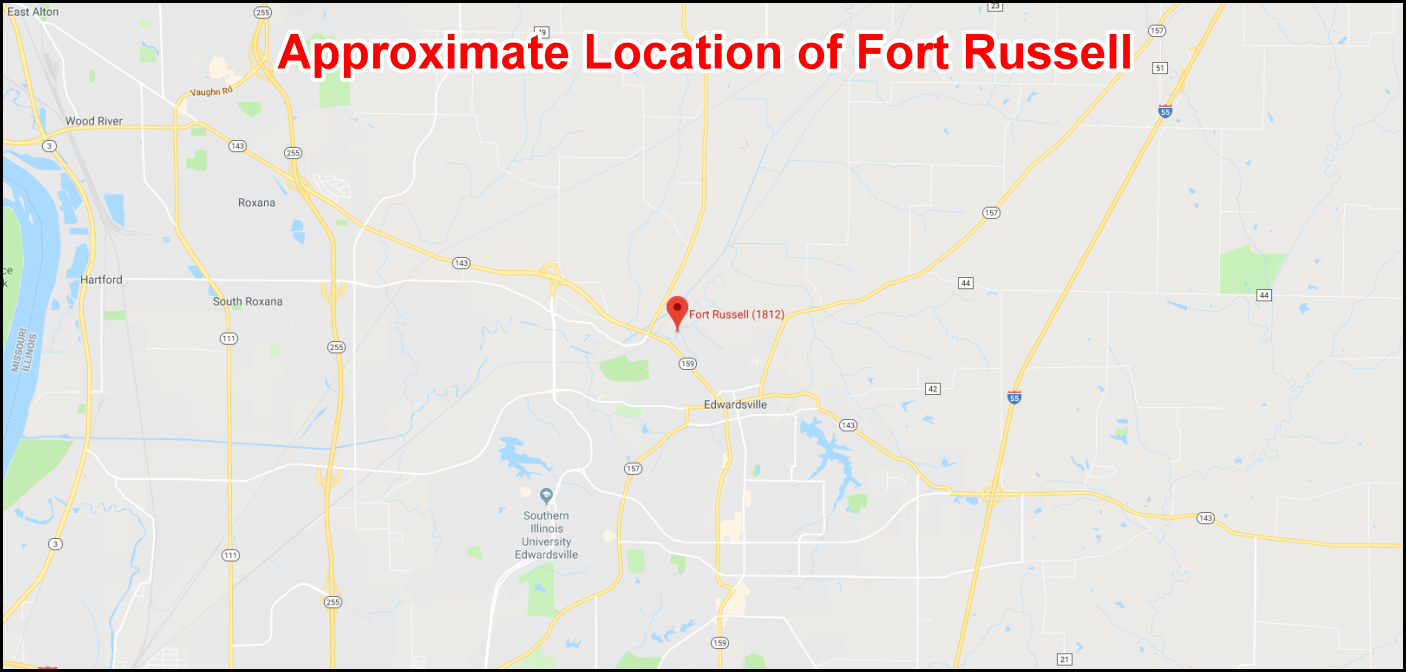
Which leaves the ongoing mystery: Where exactly was it? The best guess comes from a 1941 aerial photograph of the Edwardsville area, which may show an outline of such a site about a mile northwest of Edwardsville on Springfield Drive just east of Illinois 159 (Section 34, Township 5-8). It’s a secret that may never be unlocked.
 |
| The Marker Reads: One quarter-mile to the west stood Fort Russell, a wooden stockade which served as a base of supplies and operations for the Illinois Militia during the War of 1812. From here, for months at a time, Governor Ninian Edwards administered the affairs of Illinois Territory. The Marker has been reported missing. The Marker was near Edwardsville, Illinois, in Madison County and could be reached from Springfield Road just east of IL Rt. 159. |
Compiled by Neil Gale, Ph.D.
It's a shame we can't preserve, or at least rebuild these historic places. I realize saving a place as this didn't come to mind in 1815 but, it would sure would have been nice. For me, this is a weekend getaway spot. Just absorbing the events that took place over 20 hundred years ago is my kind of vacation!
ReplyDeleteIn this fast world we have ancient fort s ...but don't have fort that built best and latest ...said to be the best fort of Illinois
ReplyDeleteThough the fort has remained hidden from view, a group of folks are still searching, and results hold promise it will come up for air some day. As a temporary frontier fort, it was constructed with upright logs buried 48" or so into a trench. As one would imagine, without constant rotation, the logs decay quickly. Ft Russell was likely abandoned by 1815 and anything of construction value ( i.e. sawn lumber, stone, brick ) was carted off by the local area farmers, similar to the fate of Belle Fontaine. Russell may not be extinct, just in a place not looked yet. The search continues!
ReplyDeleteThis is some more current in my view logical location of the fort. They would not build a fort in a floodplain at the bottom of a hill.
ReplyDeletehttps://www.siue.edu/artsandsciences/anthropology/pdf/12_Miller.pdf
Soon, hopefully, this site will be exposed by 2 guys who have been searching and documenting for the last 3 years, with help from local land owners, an Illinois state archaeologist, a state surveyor, the Madison County Hist society president.
ReplyDeletewe have also located the missing marker, and is now in the hands of the Madison County Historical Soc.
ReplyDelete