Showing posts sorted by date for query portage. Sort by relevance Show all posts

Thursday, September 2, 2021

An In-Depth History of Jean Baptiste Pointe de Sable, Chicago's Founder.


In historical writing and analysis, PRESENTISM introduces present-day ideas and perspectives into depictions or interpretations of the past. Presentism is a form of cultural bias that creates a distorted understanding of the subject matter. Reading modern notions of morality into the past is committing the error of presentism. Historical accounts are written by people and can be slanted, so I try my hardest to present fact-based and well-researched articles.

Facts don't require one's approval or acceptance.

I present [PG-13] articles without regard to race, color, political party, or religious beliefs, including Atheism, national origin, citizenship status, gender, LGBTQ+ status, disability, military status, or educational level. What I present are facts — NOT Alternative Facts — about the subject. You won't find articles or readers' comments that spread rumors, lies, hateful statements, and people instigating arguments or fights.

FOR HISTORICAL CLARITY
When I write about the INDIGENOUS PEOPLE, I follow this historical terminology:
  • The use of old commonly used terms, disrespectful today, i.e., REDMAN or REDMEN, SAVAGES, and HALF-BREED are explained in this article.
Writing about AFRICAN-AMERICAN history, I follow these race terms:
  • "NEGRO" was the term used until the mid-1960s.
  • "BLACK" started being used in the mid-1960s.
  • "AFRICAN-AMERICAN" [Afro-American] began usage in the late 1980s.

— PLEASE PRACTICE HISTORICISM 
THE INTERPRETATION OF THE PAST IN ITS OWN CONTEXT.
 

Jean Baptiste Pointe de Sable: "Pointe" is the proper French spelling, but the final 'e' is almost always dropped in documents. The 'du' of Pointe du Sable is a misnomer (a wrong or inaccurate name or designation). It's an American corruption of 'de' as pronounced in French. "Du Sable" first appears long after his death in 1818. I use the correct spelling in this article.


Jean Baptiste Pointe de Sable was the founder of modern Chicago and its first negro resident. Pointe de Sable was his chosen legal name; he was never called Pointe de Sable during his lifetime. Pointe de Sable was an inseparable element of his name, which he had assumed by 1778. The prosperous farm he had at the north branch of the Chicagou River (the French spelling) from about 1784 to 1800 helped stabilize a century-old French and Indian fur-trading settlement periodically disrupted by the wars and raids of Indians and Europeans and abandoned by the French during the Revolution from 1778 to 1782.

The earliest known documents that refer specifically to him establish that in 1778 and 1779, perhaps as early as 1775, Pointe de Sable managed a trading post at the mouth of the Rivière du Chemin (Trail Creek), at present Michigan City, Indiana, not at Chicago, as is usually asserted. Pierre Durand of Detroit was associated with him and Michel Belleau in the ownership of this business. Here is Durand’s own 1784 account of Pointe de Sable’s post translated from his petition to Gen. Frederick Haldimand, then governor of Canada: “I found the waters low in the Chicagou River; I did not get to Lake Michigan until October 2, 1778. Seeing the season so far advanced that I could not reach Canada, I decided to leave my packs at the Rivière du Chemin with Pointe de Sable, a free negro, and I returned to Illinois to finish my business. On the 1st of March, 1779, I sent off two canoes to take advantage of the deep water [at Chicagou]. I gave orders to my commis [business manager] to take these two canoes to the Rivière du Chemin loaded with goods and to go ahead of me with all the men to help me pass at Chicagou . . . I met my commis [Michel Belleau] at the start of the bad part [of the portage] . . . Some days later, I arrived at the Rivière du Chemin, where I found only my packs [of furs]. The guard told me that M. Benette [Lt. William Bennett of the 8th regiment] had taken all my food, tobacco, eau de vie (brandy). A canoe to carry them . . . ” Durand also learned that this British force had taken Pointe de Sable prisoner as a suspected rebel back to Michillimackinac, which began an important phase of his career as a minor but valuable member of the British Indian Department.

Up to the time of his capture, Pointe de Sable had been an engagé in the fur trade, traveling on the Great Lakes, the Illinois River, and elsewhere from perhaps 1768 to 1779. From 1775 to 1779, his associate Durand was known to have been active in the upper country under an official trade license. Only British subjects were allowed to work in the fur trade, supervised by military officers and the governor of Quebec. All engagés and the license holder had to swear an oath of loyalty to the king before the commander at Montreal and sign a printed oath incorporated in the license. Wealthy individuals posted bonds that would be forfeited for the slightest infraction of the rules of the fur trade or acts of disloyalty. The Durand-Belleau license itself and documents of Pointe de Sable’s hiring at Michillimackinac have not been found. Pointe de Sable would have signed by making his mark since he was illiterate, as most engagés were. Still, he must have been a skilled man when Lt. Governor Sinclair hired him in 1780 for his semi-official operation at the Pinery, adjoining Fort Sinclair north of Detroit.

Once Pointe de Sable settled in Chicagou, in territory regarded by law as Indian-owned, he was mainly a farmer at the end of the Revolution. His farm was known, as far away as the nation’s capital, as the only source of farm produce in the area until after he moved away in 1800. Like all people living in the barter economy of the frontier, he traded with Indians and Europeans alike for goods and services he needed, but he was not a professional trader. William Burnett, who may already have had a financial stake in the farm during the time Pointe de Sable managed it, became the actual owner (of the buildings, not the land) after Pointe de Sable left in 1800. Burnett used it as his Chicagou trading post until his associate John Kinzie arrived in 1804. By the 1795 Treaty of Greenville, the Indians defeated at Fallen Timbers granted the United States a six-mile square tract at the river's mouth; Pointe de Sable was thus a tenant or licensee, not an owner, of the land.

The cessation of hostilities created an environment in which Pointe de Sable could prosper. He was a British subject in what was still British-controlled territory. It is generally forgotten that the Northwest Territory, ceded by Great Britain to the United States by the 1783 Treaty of Paris, was still almost completely controlled by British military forces and traders until 1796 with the implementation of Jay’s Treaty of 1794 and the surrender of military posts, such as Detroit and Michillimackinac, to the United States. However, British agents remained in place until the Treaty of Ghent ended the War of 1812 in 1815. In Chicago, the British agent was John Kinzie, who changed allegiance in 1812 at great personal risk. When Pointe de Sable sold [transferred] his improvements and household goods for 6,000 Livres in 1800 ($1,200 today), a value certified by appraisers Kinzie and Burnett, and moved to St. Charles in present Missouri. His farm in the Spanish colony of Upper Louisiana was comparable to that of prominent people in Cahokia, Illinois. There is no record that Pointe de Sable ever became an American citizen.

Pointe de Sable means “sand Pointe” in French and was probably taken as a surname by Jean Baptiste to identify a place (one of many so-named) important to him that has not yet been identified. Sable means sand. It can also mean black in the aristocratic Norman French or English heraldry, but only because this color was used to represent sand on coats of arms. Pointe de Sable is unlikely to have known this, for his command of English was rudimentary at best. Moreover, people of African descent were always called nègre in French America.

Pointe de Sable in any form is not a French surname found in any vital records of France, Canada, or the United States. In nearly all of the many surviving documents from 1779 to 1818, most of them written in French, in which Pointe was a party or was mentioned, his surname appears as Pointe de Sable. The Sieur de Sablé (without the Pointe) was a title of minor nobility used in the 18th century in the Dandonneau family of Quebec. This family had no known connection to Pointe de Sable, although the related Chaboillez family were prominent fur traders. A Haitian family named Des Sables, again lacking the Pointe, were French subjects and cannot be related to Chicago's founder, whose family probably did not even have a surname, despite the elaborate, undocumented assertions of a member of that family in a fanciful 1950 biography.

Pointe de Sable was born free, as Durand implied by calling him a “free negro.” He was the son of parents still not identified, possibly born at Vaudreuil, near Montreal, before 1750. A Jean Baptiste, nègre, native of Vaudreuil, is listed as an engagé in a 1768 fur trade license. Pointe de Sable’s mother was a free woman, not a slave. Children of slave mothers, black or Indian, were slaves under Quebec law, regardless of the father's status.

Where Pointe de Sable was before 1775 has not been reliably documented. In that year, he seems to have been hired in Montreal by Guillaume Monforton or Montforton of Detroit, a trader and notary at Michillimackinac, to travel there from Montreal. In the surviving British license papers, he is simply Baptiste, nègre; earlier licenses are similarly vague. There is no truth to the two-century-old myth that for several years from 1773 to about 1790, he farmed land at Peoria under a 1773 deed from the supposed British commander there, Jean Baptiste Maillet, and was a member of the militia in 1790. Aside from the fact that Maillet was a traveling engagé in the fur trade, under licenses from 1769 to 1776, and lived near Montreal, where he had two daughters born in 1768 and 1771, any such grant was illegal under British law. This myth was exploded in 1809 by the U.S. land commissioners hearing land claims at Peoria, who found that no purported British land grant presented to them, of which this was one, was authorized. The militia rolls for Illinois, published in 1890, have many men named Jean Baptiste, but none with a surname resembling Pointe de Sable.

In 1775, Pointe de Sable joined forces with the experienced trader Pierre Durand, a Detroit resident, and left Michillimackinac under the trade license of Michel Belleau. Jean Orillat, the wealthiest merchant in Montreal, financed and bonded his associates. They had previously been in Illinois. Orillat had been trading between Illinois and Montreal since 1767, perhaps earlier. Belleau and Durand travelled to Illinois. Belleau set up a post where Bureau Creek enters the Illinois River. Bureau is an obvious corruption of his name, most likely by local Indians whose dialect replaced the sound of 'l' with that of 'R.' For example, the Illiniwek Indians called themselves Irenioua (plural Ireniouaki). Bureau was recorded as early as 1790 as the “River of Bureau,” or at Bureau’s, which helps locate his post. Near this post was a conspicuous peninsula of sand (French, Pointee de sable), now called Hickory Ridge, behind which was a harbor providing a place to load canoes, pirogues, or batteaux. They spent some of their time in Cahokia, Peoria, and on the Illinois River from 1775 to 1779. They dealt with each other and with various local merchants such as Charles Marois (interestingly, he was illiterate), Charles Gratiot of Cahokia, Pepin & Benito, and Charles Sanguinette of St. Louis. 

Pointe de Sable had an account, managed by Marois, with Michel Palmier dit Beaulieu (no relation to Belleau), a wealthy farmer and prominent Cahokia citizen. Pierre Belleau, Michel’s brother, was hired to go to Illinois in 1776 by Orillat’s former partner, Gabriel Cerré. Nothing further is known of him, but Pierre and Michel seem to have been killed by Indians along the Illinois River in the spring of 1780. Michel’s estate was administered in Cahokia, where his creditors were, although, when he went to Montreal in 1777 without Durand to get his trading license renewed, he seems to have stated that he lived in Detroit. Perhaps he and Pointe de Sable were the two young male boarders in Durand’s modest household noted in the 1779 Detroit census.

Pointe de Sable was at his trading post on the Rivière du Chemin in October 1778, when Durand, with two boatloads of furs, was forced by the lateness of the season to leave his cargo with “Baptiste Pointe Sable (a negre libre - free Negro)” instead of taking it to Montreal as he had planned. Durand had left Kaskaskia in June, just before George Rogers Clark occupied it, but was delayed by the turbulent events of the time. He eventually got underway, passing up the Illinois River and through Chicagou, reaching Lake Michigan on October 2, 1778. After leaving his furs with Pointe de Sable, Durand returned to Cahokia and Old Kaskaskia Village for the winter. Perhaps he was able to settle his and Pointe de Sable’s debts to the estate of Charles Marois, who had died recently.
A trader named Guarie had built this trading cabin and farmed the land on the west side of the Guarie River [north branch of the Chicago River] as early as 1778. It's not documented when Guarie moved. Jean Baptiste Pointe de Sable established “Eschikagou  a settlement in 1790. He lived in the Guarie cabin (unsure if he purchased it or if it was vacated) and farmed the land, raising pigs and chickens, growing corn, and trading with local Indians.


Durand sent off Michel Belleau and two canoes of furs to the Rivière du Chemin on March 1, 1779. He remained in Cahokia and Old Kaskaskia Village to collect on his and Pointe de Sable’s accounts with Clark’s army. In July 1779, Durand stopped at Peoria, where he met his Cahokia friend Captain Godefroy de Linctot, the leader of a small army that had left Cahokia at the end of June. Lanctot had brought with him Clark’s commission of Jean Baptiste Maillet as captain of the Virginia militia (the Illinois Country was ceded by Virginia in 1778) at Peoria, a community he was expected to defend from attack. However, as Durand later told Lt. Gov. Patrick Sinclair, there was no fort there. A year later, Maillet was in St. Louis, and his clerk, Pierre Trogé or Trottier, was on the Maumee River in present Ohio. Linctot, coordinating his movements with those of Clark, was planning to attack Detroit. Major Arent Schuyler De Peyster, the British commander at Michillimackinac, got wind of this plan on July 3 and, on the 4th, dispatched Bennett overland with 20 soldiers, 60 armed traders serving in the militia, and about 200 Indians to intercept Linctot’s force, which, like Clark’s, never reached Detroit.

Durand met Belleau and 14 engagés at the start of the Chicagou portage des chênes. At Chicagou, the local Indian leaders brought him some bad news: Pointe de Sable had been at his post at the Rivière du Chemin when a detachment of Bennett’s forces under Corporal Gascon arrested him, about August 1st, confiscating 10 barrels of rum, food, clothing and a birchbark canoe with repair supplies, all worth 8,705 Livres (French: £94,756 or US: $98,766 today), all the property of Durand. Gascon took Pointe de Sable’s many packs of furs under guard to Michillimackinac, pending Durand’s expected arrival with additional packs. These would be brought by 30 horses provided by the Chicagou Potawatomi. Gascon took Pointe de Sable prisoner to Bennett, who was camped on the nearby St. Joseph River.

Bennett and De Peyster must at the least have known of Pointe de Sable because Bennett’s first report to De Peyster of his arrest, written at his St. Joseph camp on August 9, 1779, simply says, “Baptiste Pointe au Sable I have taken into custody, he hopes to make his conduct appear to you spotless,” without explaining who Pointe was or where he lived. As commandant De Peyster was responsible for keeping track of all traders in his area, Pointe could not have been a stranger to him; he was zealous in enforcing fur trade rules.

Pointe de Sable must have known some of the traders and Indians with Bennett because when he arrived at Fort Michilimackinac (a French fort and trading post, later British, at today's Mackinac Island, Michigan) about September 1st, Bennett reported to De Peyster that “the negro Pointe au Sable” had “many friends who give him a good character,” a clue to his earlier trading voyages. Pointe de Sable was married by now, but there is no mention of his family.

Pointe de Sable met De Peyster upon his arrival at Michillimackinac on September 1, 1779. De Peyster was waiting for news of glorious military exploits by troops under his command. Instead, he received Pointe de Sable’s demand that he pay for the property Bennett had confiscated from his trading post at the Rivière du Chemin. De Peyster refused to pay for these goods, valued at £580, treating them as spoils of war owned by a rebel trader. De Peyster knew he would have to reimburse Durand out of his pocket if they were not spoils of war. This was a sizable liability for an officer whose annual salary was £75. Durand was finally reimbursed in 1784, probably to De Peyster’s relief.

Shortly before De Peyster left for his new command at Detroit, Durand also arrived at Michillimackinac and learned that De Peyster had ordered his arrest. He managed to avoid being detained and wrote out an itemized bill for his property confiscated from Pointe de Sable’s post. Translated from French, the heading of the bill reads, “Memorandum of Property which I, Durand, left in the custody of Baptiste Pointe de Sable, free negro, at the Rivière du Chemin, which Mr. Bennett, commander, gave orders to seize.” De Peyster refused to pay this bill because, as he explained to Governor Haldimand when it was presented to him again in 1780, there was a rumor (not true) that Durand “had made lampoons upon the King, which were sung at the Cascaskias.” The miscreant was later identified as Jean-Marie Arsenault, dit Durand, no relation.

There is a widely accepted myth that Pointe de Sable’s farm of 1788 was not at the Rivière du Chemin, as amply documented at the time, but at Chicago. The evidence for this myth is worse than flimsy and can be briefly dealt with. Andreas, in his history of Chicago, drew upon an uncritical reading of the much later writings of De Peyster, which flatly contradicted his own and other documents from 1779 to 1784. De Peyster published a pseudo-historical narrative of his experiences at Michillimackinac in 1813 under the title of “Speech to the Western Indians” in his self-published Miscellanies by an Officer. In a fanciful recasting of the arrest of Pointe de Sable, De Peyster characterizes him as a handsome Negro, well educated, and with French sympathies. In fact, Pointe de Sable was illiterate, and in 1780 De Peyster had urged his successor Sinclair to hire him for a position at a sensitive British location. De Peyster further mangled the historical record by stating that Pointe de Sable was arrested by Capt. Charles de Langlade, not Bennett’s Corporal Gascon, and that Pointe de Sable was established at “Eschikagou  (a settlement founded by Jean Baptiste Pointe de Sable on the north branch of the Guarie River [1], where his farm was located).” Amazingly, Andreas and every subsequent historian have swallowed these fantasies whole, although the essential contemporary documents have been available in published form for more than a century. By the time De Peyster wrote this piece of fanciful doggerel (words that are badly written or expressed), he had probably heard from old friends, like John Askin of Michillimacknac and Detroit, that Pointe de Sable was then at Chicagou (as De Peyster spelled it in his July 1, 1779 order to Langlade), and mixed up the dates. The obvious conflict between the facts and De Peyster’s late recollection of them has regrettably never been examined to discredit students of Chicago history. No credence should be given to the late jottings of a retired officer whose memory had failed him.

Pierre Durand managed to get passage on a boat manned by black sailors that took him to the Rivière du Chemin to get the 120 packs of furs he had left there in Pointe de Sable’s absence. On October 15, 1779, De Peyster left for his new command at Detroit, replacing Lt. Gov. Henry Hamilton, now a prisoner of war at Williamsburg. Shortly after De Peyster’s successor, Lt. Gov. Patrick Sinclair, assumed command at Michillimackinac, Durand arrived with his treasure of furs. Having barely survived a harrowing stormy lake voyage, the exhausted trader landed his cargo in this small leaky sailboat about October 20. Sinclair arrested him, confiscated his papers, and refused to pay Pointe de Sable's bill. Durand’s papers included a copy of Belleau’s declaration of loyalty to Virginia, a bill of exchange endorsed to Pointe de Sable, and Virginia paper money, all worthless payments for goods requisitioned from them by Clark’s rebel forces in Illinois. This convinced the erratic and generally paranoid Sinclair that Durand and Pointe de Sable were both rebels and the confiscated property was mere spoils of war. It soon became evident, however, that both were loyal British subjects who had been victimized by Clark’s impecunious Virginia forces, like many others.

Sinclair bought more trade goods from Durand on credit and promised to reimburse Durand for the cost of shipping his furs to Montreal, promises he never kept. He failed to pay Durand for moving and repairing a house for Matchekiwish, a local Chippewa war chief. He also hired a piastre (dollar) a day to guide a war party headed by Langlade to Chicagou and down the Illinois River in 1780 to join the attack on St. Louis and Cahokia. Ironically, this war party passed the post of Michel and Pierre Belleau, who were killed about this time by Indians on British orders. Sinclair had confiscated a copy of Michel’s oath of loyalty to Virginia from Durand, which became his death warrant. Durand was never paid for anything but guiding this party and the property confiscated from Pointe de Sable. Sinclair characteristically declined to pay for about 10,000 Livres of charges on Durand’s second bill.

Pointe de Sable fared much better than Durand. Surprisingly, within a year, this prisoner, arrested under suspicion of siding with the Americans, was employed with De Peyster’s knowledge and at the request of Meskiash, village chief of the local Ojibway tribe, as manager of Sinclair’s Michigan estate, the Pinery. This property, illegally bought from Indians including Meskiash and others in 1765, was near the mouth of the Pine River at present St. Clair, Michigan. He held this position from August 1780 until 1784, when the property was sold. His wife and children had probably joined him there in a house built in November and December 1779 by British workmen. This structure was built of squared pine logs covered by hand-sawed boards. The interior was partitioned into rooms, and the board walls were plastered with clay from the bed of the Pine River.

Shortly after he arrived in the Detroit area, Pointe de Sable again pressed De Peyster to pay the 8,705 Livres. De Peyster again refused because of Durand’s supposed rebel sympathies. He was taking a big risk because if, as it turned out, these goods were requisitioned from a British subject, he would be legally responsible for paying out of his own pocket. This uncertainty hung over him until the wartime expenses of the upper posts were finally approved by the auditors in London in 1787.

The Pinery was supplied from Detroit, and the commandant there was responsible for regulating this trade, including approval of any voyages there and beyond, as far as Michillimackinac. As the officer who had jurisdiction over the Pinery, De Peyster must have had regular contact with and intelligence about Pointe de Sable, who was there with his permission and no doubt was an employee of the Indian Department. One of De Peyster’s sources would have been Meskiash, the Ojibway village chief near the Pinery, who participated in a 1781 Indian council that De Peyster had convened at Detroit.

In the late summer of 1781, Pointe de Sable was apparently running a British trading post at Ouiatenon (Lafayette, Indiana). Lt. Valentine T. Dalton, the Virginia commander at Vincennes, was kidnapped from his home by Indians and taken to Quebec. In a letter to George Rogers Clark, he describes his experiences and meeting “Jno Batiste.” At the forks of the Maumee River (Defiance, Ohio), he met Pierre Trogé (“Truchey”) of Vincennes, who was running another trading post. Significantly, he mentions one of Trogé’s former employers, LeGras of Vincennes, but not Jean Baptiste Maillet, whom he must have encountered at Peoria or Cahokia.

In 1784, Pointe de Sable shipped his household goods. Obviously the furnishings of the comfortable family home of a very loyal British subject, from the Pinery to Detroit and moved there with his family. Soon he became associated with William Burnett, a wealthy and wide-ranging trader at the mouth of the St. Joseph River, who also had a post at Michillimackinac and Chicagou. By 1788, Pointe de Sable had settled with his family at the Chicago River and was farming the land with his wife and two children. He had probably disposed of the telltale framed portraits that had adorned his home at the Pinery. The subjects included King George III and Queen Charlotte Sophia; the King’s younger brother (the Duke of Gloucester); His Serene Highness, Karl Wilhelm Ferdinand, Duke of Braunschweig-Luneberg, a cousin of George III, who had sent his Brunswick troops to Canada’s defense against the rebels; and Baron Hawke and Viscount Keppel, both First Lords of the Admiralty who had battled French fleets. These treasures from their home at the Pinery would have exposed him as a loyal British subject in a place now visited by patriotic citizens and soldiers of the new United States, such as the covert intelligence officer Lt. John Armstrong, traveling under secret war department orders in 1789.

In 1788 he and Catherine went from Chicagou to Cahokia to have their marriage solemnized (formal marriage ceremony) by Father de Saint Pierre in the newly rebuilt Church of the Holy Family. Jean Baptiste had established business and personal relationships in and near Cahokia, dating back to 1778 or earlier.

In 1790 the Detroit-Cahokia trader Hugh Heward stopped at Pointe de Sable’s farm and traded cloth for food which Pointe de Sable had grown. The cloth was a major item stocked by traders, and Pointe de Sable would not have needed it if he were himself in the business.

In 1794, the legendary Shawnee war chief Blue Jacket was making plans to move out of Ohio after Gen. Anthony Wayne’s defeat of his British-backed Indian forces at Fallen Timbers, near present-day Toledo. He thought of going to “Chicagou on the Illinois River” in British-controlled territory. Still, he didn’t because the defeated Indians were forced to cede a six-mile square tract at the mouth of the Chicago River to the United States in the 1795 Treaty of Greenville. A 1794 smallpox epidemic that killed 50 Indians at Chicagou must also have discouraged him.

In 1794, Pierre Grignon, a British trader living at Green Bay, paid a visit to Pointe de Sable at Chicagou. The brief report of this meeting by his brother Augustin Grignon included a cryptic reference to a government commission Pointe de Sable exhibited to his visitor, who probably then considered himself a fellow British subject in British-controlled territory. It seems unlikely that the United States would employ Pointe de Sable as a secret agent, a man who had been a British subject working at the Pinery, a post controlled by the British Indian Department for several years. The Grignons were themselves employees of the Indian Department as late as 1815. In fact, John Kinzie, the Chicagou trader who acquired Pointe de Sable’s farm in 1803, was an officer of this department. He narrowly escaped hanging or being killed by pro-British Indians for treason committed near Detroit after he had switched his allegiance to the United States in 1812. He had been reported by Shawnee Chief Tecumseh as attempting to win Indians to the American side while bringing them gunpowder furnished by his department.

Suzanne Pointe de Sable was married at Cahokia in 1790 to Jean Baptiste Pelletier; Father Pierre Gibault, long sympathetic to the American cause, officiated. The young couple must have lived with or near her parents in Chicagou. Their daughter, Eulalie, was born there in 1796.
The Kinzie Mansion. The House in the background is that of Antoine Ouilmette. 
Illustration from 1827.


Successive owners and occupants include:
  • Jean Lalime/William Burnett: 1800-1803, owner. (A careful reading of the Pointe de Sable-Lalime sales contract indicates that William Burnett was not just signing as a witness but also financing the transaction, therefore controlling ownership.)
  • John Kinzie's Family: 1804-1828 (except during 1812-1816).
  • Widow Leigh & Mr. Des Pins: 1812-1816.
  • John Kinzie's Family: 1817-1829.
  • Anson Taylor: 1829-1831 (residence and store).
  • Dr. E.D. Harmon: 1831 (resident & medical practice).
  • Jonathan N. Bailey: 1831 (resident and post office).
  • Mark Noble, Sr.: 1831-1832.
  • Judge Richard Young: 1832 (circuit court).
  • Unoccupied and decaying beginning in 1832.
  • Nonexistent by 1835.
In 1796, Pelletier got a receipt at Chicagou for some furs, credited to his father-in-law’s account, signed by the trader Jean Baptiste Gigon as agent for François Duquette of Michillimackinac and St. Charles. The receipt acknowledges payment of two dozen eggs to have the furs pressed and packed for shipment, a service not necessary if Pointe de Sable had a trading post equipped with the press needed to package furs. Three years earlier, Duquette, under a British trading license, had been selling trade goods below cost to the Wabash Indians in an effort to keep them loyal to the crown.

The Pelletiers and another pair of Chicagoans, the Le Mai's, went to St. Louis in 1799 to have their children baptized. Little Eulalie Pelletier, whose grandparents were not present, had two interesting godparents. Hyacinthe St. Cyr, now a prominent merchant in St. Louis, was the brother of Baptiste St. Cyr, who in 1770 had led a group of Jean Orillat’s engagés to Chiquagoux (another French name for Chicago) to evaluate it as a site for a trading post, which Orillat never established. Hyacinthe’s wife, Hélène Hebert, acted as godmother. St. Cyr would have known Pointe de Sable and may have acted as his representative at the ceremony. Hélène’s brother François had been Pointe de Sable’s fellow voyageur from Detroit to Michillimackinac in 1775.

Suzanne`s brother Jean Baptiste Pointe de Sable [Jr.], of whom little is known, was living in St. Charles before 1810. He worked for Manuel Lisa, a Spanish trader of St. Louis, as an engagé on an 1812-1813 trading expedition up the Missouri River. He died in 1814, and his father was the administrator of his meager estate. The surviving probate documents do not mention any heirs. It is not known when Catherine died. Pointe de Sable sold [transferred] his Chicago property in 1800 to his neighbor Jean Baptiste La Lime. William Burnett financed the deal, guaranteeing payment because La Lime put up no earnest money. Catherine did not sign the bill of sale, probably because she was no longer living. Jean Baptiste Pelletier may have been alive in 1815, but nothing is known of Suzanne and Eulalia at that time, nor indeed since 1799.

In the fall of 1800, Pointe de Sable moved from Chicagou to St. Charles in Spanish Upper Louisiana. There he bought a house and lot from Pierre Rondin, a free negro, and acquired two tracts of farmland. François Duquette was now his neighbor. He became involved in various real estate transactions that did not work out, including perhaps even the land he had bought for his home based on Spanish land titles of doubtful validity. In some of these deals, he was joined by his son. By 1809, he was in financial difficulties. Duquette got a judgment against Pointe de Sable for negligence in 1813, but the sheriff could not collect because Pointe de Sable was insolvent.

Somehow, Pointe de Sable’s name had become involved in the rampant land speculation of the time. Two spurious claims were made by men who had supposedly purchased his rights under acts of Congress to land in Illinois. These claims were filed by land jobbers with the U.S. Land Office at Kaskaskia about 1804, based on the fictitious assertion in perjured documents that he and his family had lived and farmed at Peoria from 1773 to after 1783 and that Pointe de Sable had served in the militia there in 1790. Of course, Pointe de Sable has been well documented as being elsewhere. In 1809, the Land Office rejected these claims as unproven. In 1815, it grudgingly and tentatively recommended that Congress consider approving these claims, but only to Pointe de Sable himself, who was probably unaware of the use of his name by swindlers. The disappointed speculator, Nicolas Jarrot, must not have told Pointe de Sable about Congress’s tentative approval in 1816; in fact, he seems to have abandoned these and several other dubious Peoria claims, and he did not mention them in his will, written in 1818, the year Pointe de Sable died. Had deeds been issued with Congressional approval, Pointe de Sable would have received title to 800 acres of valuable real estate in Peoria. But this was not to be, and his financial woes increased. No further land claims were made in his name before another land office in 1820, specifically under the law for consideration of Peoria claims, probably because they had already been exposed as fraudulent and would have been disputed by the testimony of long-time Peoria residents who recalled events well before 1779, but who did not remember the well-known Pointe de Sable.

By 1813, Pointe de Sable was destitute and had even been forced to borrow household utensils from his neighbor, Eulalie Barada. This Eulalie, who has been carelessly confused with Pointe de Sable’s granddaughter Eulalie Pelletier, was the daughter of Louis Barada (Baradat) of St. Charles, a prominent landowner, and Marie Becquet, a native of Cahokia. Eulalie was born in St. Louis, probably in 1788, and married her first husband in 1802. In 1813, Pointe de Sable deeded all his remaining property to his “friend” Eulalie, not for money, but for her promise to take care of him for the rest of his life in sickness and in health, to do his washing, provide firewood, repair his house, supply corn to feed his pigs and chickens, and to arrange for his burial in the parish cemetery. She and her second husband, Michel De Roi, both made their marks on the 1813 deed. Pointe de Sable affixed his usual “signature,” the block capitals IBPS, this time writing the S backward.

On August 28, 1818, Pointe de Sable died quietly in his sleep at the age of seventy-three. On the 29th, he was buried in the St. Charles Borromeo parish cemetery. The priest’s handwritten entry on the burial register describes him as nègre. Unlike the usual burial records of this period, there is no mention of his age, origin, parents, relatives, or people present at the ceremony. Nor is there any record of probate proceedings.

The contemporary documents, long-neglected and never assembled, tell a fascinating story of a successful free-born negro entrepreneur, advancing through a series of significant careers to a position of prominence in Chicagou and then in his final tragic years to poverty and ignominy (disgrace). 

The founder of the modern city of Chicago merits nothing less than recognition of the facts of his life.

NOTE: Chicago's Michigan Avenue Bridge was officially renamed the "DuSable Bridge" in October 2010 to honor Jean Baptiste Pointe de Sable, the first negro, a non-native settler in Chicago.
Michigan Avenue Bridge, Chicago
Compiled by Dr. Neil Gale, Ph.D.
Contributor John F. Swenson


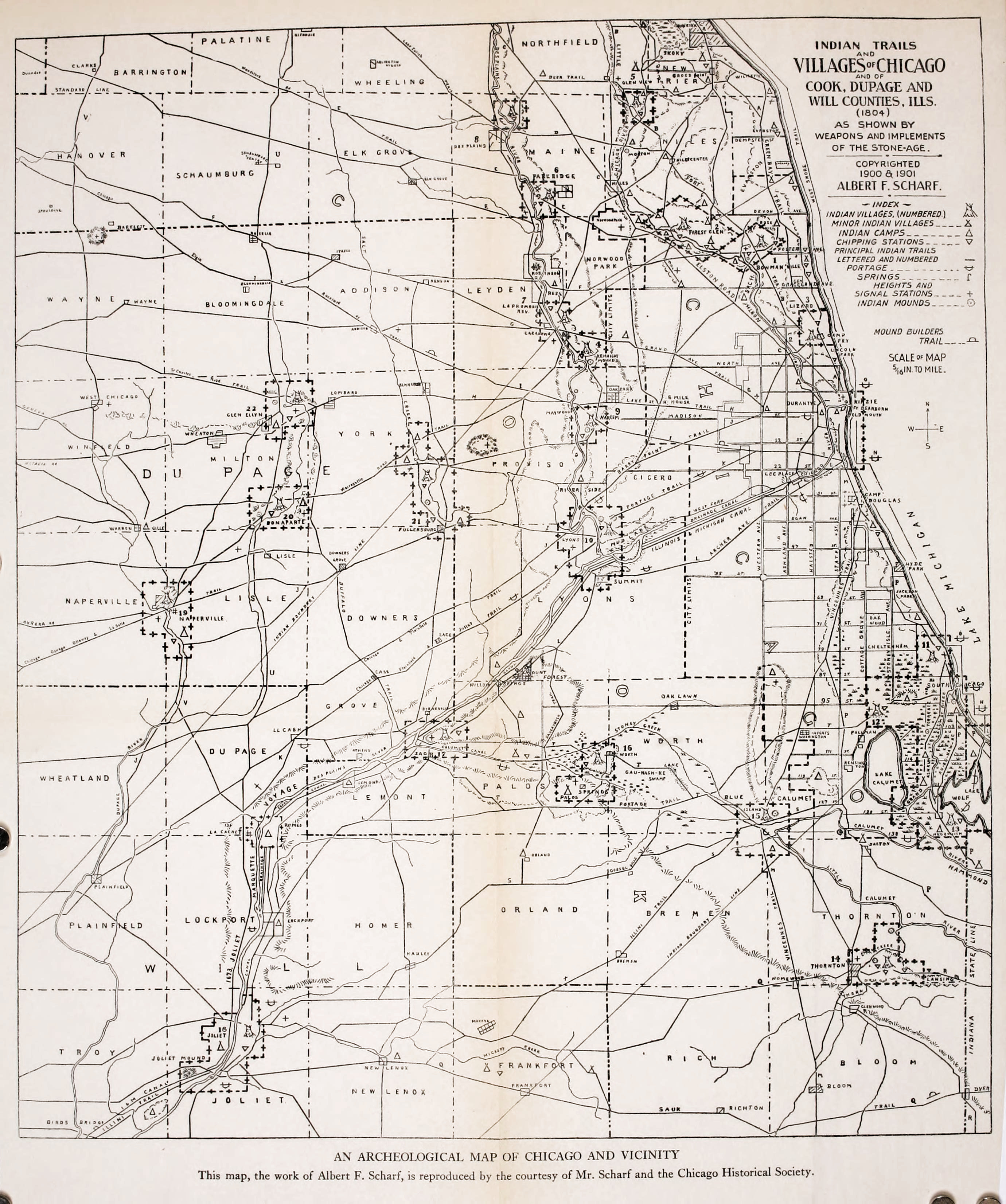
[1] Guarie or Guillory River (Guary, Gary): The first non-indigenous settler at Wolf Point may have been a trader named Guarie or Guillory. Writing in 1880, Gurdon Saltonstall Hubbard, who first arrived in Chicago on October 1, 1818, stated that he had been told of Guarie by Antoine De Champs, the man in charge of the “Illinois Brigade” of the American Fur Company, and Antoine Beson, who had been traversing the Chicago Portage annually since about 1778. Hubbard wrote that De Champs had shown him evidence of a trading house and the remains of a cornfield supposed to have belonged to Guarie. The cornfield was located on the west bank of the North Branch of the Chicago River, a short distance from the forks at what is now Fulton Street; early settlers named the North Branch of the Chicago River the Guarie River.

[2] The Métis (French) refers to a group of Indigenous peoples who inhabit Canada's three Prairie Provinces and parts of Ontario, British Columbia, the Northwest Territories, and the Northern United States. They have a shared history and culture and are of mixed Indigenous and European (primarily French) ancestry. They became a distinct group through ethnogenesis by the mid-18th century during the fur trade era.

“The Autobiography of Gurdon Saltonstall Hubbard" (in pdf), by Gurdon Saltonstall Hubbard, published in 1911.

Sunday, August 8, 2021

Beverly, officially Beverly Hills, and Surrounding Chicago Communities History.


In historical writing and analysis, PRESENTISM introduces present-day ideas and perspectives into depictions or interpretations of the past. Presentism is a form of cultural bias that creates a distorted understanding of the subject matter. Reading modern notions of morality into the past is committing the error of presentism. Historical accounts are written by people and can be slanted, so I try my hardest to present fact-based and well-researched articles.

Facts don't require one's approval or acceptance.

I present [PG-13] articles without regard to race, color, political party, or religious beliefs, including Atheism, national origin, citizenship status, gender, LGBTQ+ status, disability, military status, or educational level. What I present are facts — NOT Alternative Facts — about the subject. You won't find articles or readers' comments that spread rumors, lies, hateful statements, and people instigating arguments or fights.

FOR HISTORICAL CLARITY
When I write about the INDIGENOUS PEOPLE, I follow this historical terminology:
  • The use of old commonly used terms, disrespectful today, i.e., REDMAN or REDMEN, SAVAGES, and HALF-BREED are explained in this article.
Writing about AFRICAN-AMERICAN history, I follow these race terms:
  • "NEGRO" was the term used until the mid-1960s.
  • "BLACK" started being used in the mid-1960s.
  • "AFRICAN-AMERICAN" [Afro-American] began usage in the late 1980s.

— PLEASE PRACTICE HISTORICISM 
THE INTERPRETATION OF THE PAST IN ITS OWN CONTEXT.


The Weekly Review of Beverly Hills, Chicago, in its issue of October 29, 1926, said:

The Weekly Review presents herewith the first of a series of articles on the history of Beverly Hills, which are published through the courtesy of Mrs. Walter F. Heinnemann, 10423 S. Seeley Avenue.

The seven articles appeared from October 29, to December 17, 1926. They were copied from the files the Weekly Review graciously made available and have been reproduced for the convenience of local residents.

A sociological survey of Beverly Hills involves many problems peculiar to that community. Boundaries have shifted, are shifting today; the entire boundary line of the district has never been officially determined and can be given only according to the opinion prevailing at present.

Beverly Hills is a suburban community inside the city limits of Chicago. It lies east of Western Avenue from 87th Street to 107th Street. Its eastern boundary is the Right-of-Way of the Chicago, Rock Island, and Pacific Railroad (called the Rock Island R.R. forward) from 87th Street to100th Place, Charles Street to 103rd Street, and Church Street between 103rd and 107th Streets. This district includes the eastern part of the elevation known in the early days as the Blue Island Ridge and two lower ridges lying almost parallel to it on the east. These elevations have been and in many places still are heavily wooded, the trees being, for the most part, several varieties of oak.

Beverly Hills was entirely a residence community. There were no business that does not exist to meet local needs. There is no hotel, no restaurant, except in connection with a bakery, no moving picture theater, and only one apartment house. There are a few two-family houses, most of them built to resemble single-family dwellings. There is no streetcar inside Beverly Hills, the only transportation being the suburban line of the Rock Island R.R. Most of the houses are occupied by their owners and are surrounded by well-kept grounds.

There are two parks, seven churches, two public schools, four private schools, the latter not including music and dancing schools. The State Bank of Beverly Hills has been opened—in August 1926—the first bank in Beverly Hills. The residents are dependent on Washington Heights for their post office, freight depot, express, and telegraph.

The history of most communities reveals a shifting population and changing social structure in a geographical location of more or less fixed boundaries under one name. The population of Beverly Hills has changed by addition only and comparatively slowly, but the community has been known by several well-established names. The changes of name and shifting of boundaries have made research into the history of Beverly Hills difficult and confusing. It has seemed best to give as full and detailed a history as possible of that period ending in 1874, the year the Village of Washington Heights was incorporated. 

To understand the history, it will be necessary to review first the succession of names. The whole elevation of land of which Beverly Hills is a part was originally called Blue Island, and this name was chosen by the first village, which was located at the south end of the island, the present city of Blue lsland. After that, the rest of the ridge was called North Blue Island until the early 1870s.

In 1844 Thomas Morgan bought the Blackstone House and established his home there. This was about 92nd Street and Pleasant Avenue. He called the place Upwood. Although he owned perhaps 3000 acres, the name Upwood seems to have been confined to the neighborhood of his house and only while he lived there.

A few years after 1865, what is now Washington Heights was called "The Crossing." In 1874 the village of Washington Heights was incorporated. It included the higher land between 107th and 95th Streets. The name seems to have been chosen by real estate men to describe the three ridges of land. But the names Washington Heights and Morgan Park were used almost interchangeably for some time.

In 1870 the first train ran over the branch line of Rock Island R.R. This line left the main track at about 97th Street, curved west on 99th Street to near Wood Street where it turned south and continued through Morgan Park to Blue Island. The station near 97th Street was called "Dummy Junction." 
There was a station or rather a platform on the south side of 99th Street near what is now Beverly Avenue and was then Oak Street. It was called the Oak Street station. Today's station.
The next was at Prospect Avenue and was called the Prospect Avenue station. The one at what is now 103rd Street was known as Tracy. Tracy Avenue was the name of that street, named for a Rock Island conductor. The one at 107th Street was called Belmont.
A steam engine called the 'dummy' train had the engine enclosed so that it would look like a passenger car, hence the name 'dummy.' The story goes that if the horses saw the engine, they would get spooked. It was thought that the more familiar appearance of a coach presented by a steam dummy, as compared to a conventional locomotive engine, would be less likely to frighten horses when these trains had to operate in city streets. Later it was discovered that it was actually the noise and motion of the operating gear of a steam engine that frightened horses rather than the unfamiliar outlines of a steam engine.


In 1889 the suburban line was changed. The new line left the mainline at Gresham, and following its present course, joined the old line at 99th Street. This gave a new series of names, Beverly Hills at 9lst Street, Longwood at 95th Street, and Walden at 99th Street.

Annexation by Chicago of what is now considered the Washington Heights community area took place in three stages. In 1890 the area north of 95th, including the Brainerd subdivision, was annexed along with South Englewood. Later that year, the Village of Washington Heights voted to join them. Annexation of Fernwood in 1891 brought the last section of the current community area within the city of Chicago.

The people who lived near to what was called the "Dummy Line" and who went back and forth between these stations and the city got in the habit of saying they lived at Tracy or Longwood even though they were inside the village of Washington Heights and its post office, freight station, and stores.

When they wanted to indicate the higher ground in the village of Washington Heights and north of it by some inclusive name, many people called it The Ridge.

In 1917 various agencies petitioned the Rock Island R.R. to change the names of all the stations between 9lst and 107th Streets to Beverly Hills, adding the street name to each. This was done except at Belmont, over which there was some disagreement as the station lay south of 107th Street and therefore in Morgan Park territory. A vote was taken in 1925 of the people who use this station, and, following this, the station was named Beverly Hills, 107th Street.

The giving of one name to the seven stations which were half a mile apart in a homogeneous community was probably suggested by the action of the Chicago Telephone Company, which chose the name Beverly for its new exchange, which, in July 1914, replaced three old exchanges named Washington Heights, Longwood and Morgan Park. The name Beverly was, of the local names available, best suited for telephone use.

This long but necessary discussion of names may be extended to include Longwood Manor, though it is not part of Beverly Hills. This is the name chosen in 1924 by that part of the old village of Washington Heights, which lies between Beverly Avenue and Vincennes Avenue and 95th Street and 100th Place. Two Rock Island R.R. stations on the mainline have been painted in the mid-1920s with the names of Longwood Manor-95th Street and Longwood Manor-99th Street.

The history of the beginnings of Beverly Hills has been written by Miss Alice S. Barnard and her brother, the late W.W. Barnard. Their father was William Barnard, who came out in 1834 as a teacher for the Morgan family. In 1841 he bought a farm extending north from 103rd Street, where he lived in 1847, and bought a farm lying between 103rd and l07th Streets and between Wood Street and about Longwood Drive. The two brothers, William and Erastus, married sisters, daughters of Wm. Wilcox bought 180 acres in 1844. Mr. Barnard's paper was written for a meeting of the "Fortnightly Club of Tracy" in 1894. Miss Barnard's papers were written for the Historical Society of Morgan Park in 1924. Miss Barnard has given the writer much valuable help, including permission to make use of these papers, which will be largely quoted.

The following is an extract from Alice S. Barnard's "Historical Sketch of Beverly Hills," which extract originally appeared in the weekly "The Chicago Democrat (1833-1846)," Tuesday, August 4, 1835, when the population of Chicago was an estimated 3,625:

"Nearly south from this town and 12 miles distant is Blue Island, situated in the midst of an ocean of prairie. The name is peculiarly appropriate. It is a table of land about six miles in length and, on an average about two miles in breadth, of an oval form, rising suddenly some 30 or 40 feet high out of an immense plain that surrounds it on every side. The sides and slopes of the table, as well as a portion of the table itself, are covered with a handsome growth of timber, forming a belt surrounding about four or five thousand acres of prairie except a small opening at the south end. In summer, the plain is covered with prairie grasses and luxurious herbage. It is uninhabited, and when we visited it, from its stillness, loneliness, and quiet, we pronounced it a vast vegetable solitude. When viewed from a distance, Blue Island appears standing in an azure mist or vapor—hence the appellation 'Blue Island.' 

A map of Indian trails in the Chicago Historical Society shows that two trails—one from a portage trail from the mouth of the Calumet River to Lemont and Lockport, and another to Vincennes, Indiana passed through this region, crossing it at Washington Heights. From this crossing, the portage on or near the line of 103rd Street, about one-half mile, then deflected slightly to the south, probably to avoid a slough, crossed the island diagonally, going down the west slope where Mount Olivet Cemetery is. The Vincennes Trace followed the low ridges to the east of this table of land, crossing this island through the present site of the Village of Blue Island. The map also shows signal stations at both the north and south ends of the island and a village on Stony Creek just south of Blue Island. Arrowheads, hatchets, etc., found by those who first turned the sod in this vicinity, bear silent witness that the Indians were here. Evidence of fires and many Indian implements were found by E.A. Barnard on a sandy ridge that was on or near the portage as described above. The Potawatomi Indians met in the last great council with the whites, held near Chicago in the autumn of 1833, a few months before the description of Blue Island quoted above, was written, and signed away their last Illinois lands. The tribe of Potawatomi Indians was in the region until 1844, but the treaty devised by the U.S. government forced their removal to Kansas and Oklahoma. E. A. Barnard stood on the corner of 47th Street and Vincennes Avenue in 1847, saw the last of them in a train of 35 or 40 wagons pass by."


''For 25 years after that, occasional stories floated around of having seen an Indian who had returned to visit the home of his fathers.

Probably the reporter for the Chicago Democrat drove out over the Vincennes road, the only well-established thoroughfare, the survey of which was completed in 1832 and its course marked by milestones, giving the distance to Vincennes. The course of this road from Gresham to Blue Island was not that of our present Vincennes road. From Gresham, it ran a little south of west diagonally to the Blue Island, striking it near 91st Street where it went uphill and ran along nearly south a little west of the grove skirting the east side of the island. 

There was a milestone on 115th Street on top of the hill and one on 123rd Street east of Western Avenue. It went downhill at the south end of the island, nearly at the same place as the present Western Avenue. Many of us remember a post · with a hand pointin9 east down 95th Street marked "To Chicago" where Robey Street (Damen Avenue) enters 95th Street from the north. This post was erected to turn travelers down the new town line road.

The first white settler, De Witt Lane, built his log cabin in 1834, south of 103rd Street to the east of the grove, which bordered the island's west side. The same year Norman Rexford built a large log house in the northeast part of the island near 91st Street. He put up a sign "The Blue Island" and entertained travelers. Both of these first settlers soon moved. Mr. Lane sold his claim in 1836 for $1000 and moved to Lane's Island. Mr. Rexford moved out of our vicinity to the south end of the island.

Jefferson Gardner built a house in 1836, which he built as a tavern. This house, although additions have greatly altered it, still stands (in 1926). My grandfather, Wilcox, bought this house, and his family moved into it in 1844. There were five other houses in the vicinity. The two log houses of 1834 are no longer occupied. The Pringle house where Mount Olivet Catholic Cemetery is, the Peck house near what is now the corner of 95th and Western, the Blackstone house near where the old Rexford tavern was. All of these were commodious frame houses. The Springhouse was a small house on the site of the Vanderpoel School and so-called because there was a natural spring of water there. A log house near where 95th Street goes downhill at the west side of the island completes the list for our neighborhood. The Village of Blue Island had a cluster of houses." 

Excerpt from "The Original Tracy." by W. W. Barnard from Tracy 50 Years Ago. 1894:

''Let us look at the present site of Tracy as it appeared then from the top of the hill, choosing a familiar spot, about where Mr. E. L. Roberts lived (the corner of 101st Street and Longwood Drive). The whole country was a common, covered with a growth of nature's sowing, the only exception being five or ten acres around each settler's home. From the point selected you may look north over an unbroken prairie and see in the distance the smoke hanging over Chicago, which then extended no further south than 12th Street (Twelfth '12th' Street was renamed Roosevelt Road on May 25, 1919). To the east, the view is quite unobstructed, as the ridges, which were covered with trees, had then only brush which the prairie fires kept so low that with very few exceptions, their tops rubbed against the shoulders of a man passing through. Looking south the view between the hill and the ridge where the Dummy Track ran, was a slough in which the waters seldom dried up even in midsummer, and the greater part of the season was difficult to cross. Conclusive of this fact it is stated, a sandhill crane, as late as in the 1860s, built her nest for several years between Uncle Erastus' house and the site of the Tracy depot (corner of S. Wood Street and 104th Streets), unmolested. No one would wade out after the eggs. Also, when he fenced his farm, the corner of Wood Street and Belmont Avenue was left without fencing, the water there is so deep that the cattle would not cross. Father told of driving, also, from here to Purington, Illinois on ice.
 
NOTE: Purington was a railroad station located 14.4 miles southwest of the La Salle Street Terminal of the Rock Island R.R. It was a station between Washington Heights at 12.0 miles and Blue Island-Vermont Street at 15.7 miles from Chicago. The Purington station was at 119th Street and S. Wood Street, {Geolocation: 41°40'38.9"N 87°39'58.6"W} that served the Purington-Kimbell Brick Company, and the small residential area serving employees the brick factory.

This slough was covered with a growth of coarse grass edged by high weeds. The weeds were the thickest for two or three rods just under the bluff, especially where the ravines poured their waters into the lowlands. Here, in autumn, wild artichokes, wild sunflowers, and ironweed waved their yellow flowers high above the heads of the tallest men, far surpassing in height the young oaks and hickories beyond. Their rank growth was attained during the summer when the immense swarms of flies kept the cattle away. When the frosts finally killed these insects, droves of cattle, from 50 to 100, entering them would be completely hidden from view in the high grass and weeds. Father tells of one day being in the weeds with a farm wagon and a yoke of oxen, having stepped a few rods (1 rod = 16.5 feet) away he could not find them again except by shouting to his brother, who had remained with the team. The ravine opposite Mr. Hauke's was known as Horse Thief Hollow. Here horse thieves utilized their friendly shade as a hiding place. 


On the place just west of our present school house jointed bluegrass and pea vine grew together and were so dense and thickly interlaced that snakes ran along on the top of them.

Where the fires had swept the ground clean of the coarse growths the more delicate varieties of prairie flowers, phlox, shooting stars, violets, etc., literally covered the earth with varied and beautiful flowers as the grass covers with green, a profusion of bloom of which we have no adequate conception. The orchid family was represented by several varieties of lady slippers, of which great masses showed their pink and white or yellow heads under the trees at the edge of the groves. Wild fruits were abundant. West Pullman was then a huckleberry patch. Wild strawberries grew thickest on the prairie east of Prospect. Aunt Mary tells of seeing the ground red with them at their place after her older brothers had mowed off the long grass with a scythe so she could find them. Blackberries were thick on almost all of the ridges. Plums were plenty. Hazelnuts were found, but the hickory trees were too small to bear the abundant supply which we enjoyed in our childhood. 

The nearest adjoining community was to the south, at Blue Island, where lived the Robinson, Rexford, Wattle, Jones, Wadham, and Brittan families and where Samuel Huntington, Mrs. Sutherland's father, came almost, if not quite, a half-century ago. Kyle's tavern, the old ten-mile house on Vincennes Road near Auburn, was the first house north. The nearest house east, situated a little west of a point where State Street strikes the ridge east of South Englewood, was occupied by a member of the great Smith family. The nearest schoolhouse was at Blue Island, where the Methodist circuit rider spoke on Sunday. The doctor came from Chicago.

The Vincennes Road has been mentioned as on the hill, later travel followed the present line of Vincennes Road. Far away settlers in Indiana and Illinois carried their produce to market in Hoosier wagons, called prairie schooners, that is, wagons with white canvas covers. Long trains of these passed by from morning till evening, their numbers fully equal to that of the teams which now drive over the road. When nighttime came, their campfires glowed in the darkness. Near grandmother's house where they could enjoy the water from her excellent well was a favorite camping ground, and one of the diversions of the family was to visit the campers in the evening. 

Cattle, hogs, sheep, and occasionally turkeys drifted across the prairie in droves of from 100 to 500. In the fall thousands of these animals covered the prairies, for miles around the city as thick as they could be herded, in separate droves, waiting to get into the stockyards at 12th Street. 

The wild animals had not wholly disappeared, yet were greatly reduced in numbers. At night the howl of the wolf filled the air, but this occasioned no alarms. The game, such as prairie chickens, pigeons, quail, rabbits, squirrels, etc., were abundant and with guns and traps, the tables were well supplied. The only large game was the deer, the hunting of which afforded the most exciting sport. Preparatory to these hunts in the fall of the year it was the habit to burn off the prairie grass beyond the timbered ridges to the west. These fires were started and spread by a man mounted on horseback dragging a long burning rope saturated with turpentine through the dry grass. This left the prairie clear for the horses and hounds. The 'Morgan Boys,' as they were always called by my uncles, kept a pack of 25 or more greyhounds for deer hunting. Taking advantage of the fact that the deer would come to water then always found in the slough in this valley, the hunters would gather well-mounted on horseback, with their dogs and start the game to the west in a wild chase across the prairies. The strife among the hunters was to reach the game first and claim the horns as a trophy. 

Stagnant water and the breaking up of the new soil made prevalent the fever and ague. Many families still talk of all being sick at one time and of retiring to bed with a pitcher of water to quench the thirst which was sure to come and to which no one would be able to administer. Chills every day for a whole year were not infrequent experiences.

Prairie fires were very frequent and much dreaded. I feel no account of the early days of Tracy would be complete without a prairie fire. In the afternoon of an autumn day of 1845, our family had their first experience with a prairie fire. Grandfather had died within the first few months of their residence here. The oldest son was sick in bed with the ague. Grandmother with her four younger sons and 14-year-old daughter went out to fight the flames, but Mary who was too small to help, remained at home, carrying water to her brother watching the fire. As she looked to the west and south she heard loud roaring and saw the flames running to 10 to 12 feet high where they reached the tall weeds and extending as far as she could see. Eagerly she watched the family who was fighting the flames. They had nothing with which to plow and they could only set backfires and whip it with wet bags and brush. They fought heroically but were continually obliged to retreat. Nearer and nearer the house it came, but at last, when it came to the low grass only a few rods from the door the fighters conquered. It was the custom to plow around the houses and stacks for protection against these fires. Sometimes two circles were plowed and the grass between them burned off, thus an effective barrier was made. Dr. Egan, one of the early doctors of Chicago, asked one of the farmers the best way to protect his stacks from fire and was told to plow around them and burn between. He followed the instructions by plowing several times around the stacks and then burning between them and the stacks, which resulted in his burning up his own hay.

Someone has asked me to add a few words about the price of real estate. In 1836 Mr. Lane sold his pre-emption rights to 160 acres for $1000. As long ago as that real estate had its ebb and flow in prices. Soon after this real estate went down. The land around here was sold for $1.25 an acre and many said it was not worth that."

The appended Material is taken from Alice S. Barnard's "Historical Sketch of Beverly Hills."

"In 1852 the Rock Island railroad was completed. A stagecoach route that had been passing through Blue Island since the late 1830s was discontinued. Trains stopped at Blue Island Village and at times a certain train stopped on signal at 95th Street. All produce was still hauled to Chicago in wagons. The line of the Vincennes road was altered and travel followed the new railroad. The drainage of the land by the railroad made this possible. In time the name followed the travelers, the road Commission formally gave the name Vincennes road to the new route.

I can learn of not more than ten or twelve houses in 1852, about twice as many as bought in 1844. My father bought land and in 1851 built upon it. John Lynch had a home here. Reuben Smith lived on Western Avenue near 109th Street. Probably the first resident on the site of Morgan Park, William Betts, had a good house on 103rd Street on the West Side of the Island. I have not been able to learn the date when the town line roads were first used. Part of them—certainly 95th Street and Western Avenue—were used in 1852 or '53. A notice in the Chicago Democrat in July 1853, called for subscriptions to the stock for the new Plank road. This road was built beginning near 87th or 9lst Street on Western Avenue where the toll gate stood. It ran into the present Blue Island Avenue at 26th Street. This was the most direct route from Blue Island to Madison Street. It became a free road in the early 1860s.

Timothy W. Lackore, fresh from the California goldfields, where he met with very moderate success, settled here in 1853, having bought the land on both sides of Western Avenue, extending some distance along the north side of 95th Street. The coming of the Lackore 1s was a notable event—there were so many of them who followed their leader, either that year or very soon. There were the three brothers, Timothy, Lemuel, and William, their three cousins, Luke Lackore and the Brightenballs, and Mullens, a cousin of Mrs. William Lackore and parents of Mrs. Timothy—eight families. Then they started things. Nat Mullen taught the first public school in the old spring house. Luke Lackore, a Methodist exhorter, led the first gathering for public worship in the Peck House, then owned and occupied by T. H. Lackore, built a blacksmith shop on the northwest corner of Western Avenue and 95th Street which he and Lemuel ran. Here you might see groups of men talking at a corner grocery (meaning of the word; grocery). The district school was discontinued and it was soon moved to a temporary structure about one-half mile west on 95th Street. On the north side of 95th Street, about two blocks east of Western Avenue there stood a row of poplar trees which were on the edge of the ground of the district school which was completed in 1856—the North Blue Island School. Luke Lackore continued to hold religious meetings, class meetings, etc., after the first one mentioned above and when the schoolhouse was finished, North Blue Island became a regular preaching station where a Methodist circuit rider held services once every two weeks.'' 

The following is contained in Miss Alice S. Barnard's "Reminiscences of North Blue Island in the 1860s:"

"By 1860 most of the land in this vicinity was fenced and tilled as farms. But considerable tracts, notably hundreds of acres owned by the Morgans, were neither tilled nor fenced, and the cattle of the community pastured in it freely. It is owing to these untilled acres that those of you who came in the 1870s and 1880s found so great an abundance and variety of wildflowers, especially the prairie flowers, as most of the farmers owning groves—the habitat of the wood flower, spared a part at least of the tract.

The 1860s—the decade of the Civil War! When I was a very little girl, standing by my mother, her brother in a tense whisper said something in her ear. With a look of surprise, she said 'Another?' It was many years after before I learned what this might mean. A few times my uncle, going in the morning to the barn, found a fugitive slave lying in the hay of the manger where he could feel the warm breath of the cattle. I asked the aunt who told me this: Did the farmers have similar experiences? She replied 'I don't know, we never told—you didn't know which side they were on.' 

When Lincoln was a candidate for president there was held in the North Blue Island schoolhouse what was probably the first political meeting of the neighborhood. The torch-light procession came down the road giving invitation in song to 'Come and join the Wide Awakes, the Wide Awakes of Illinois,' feelings at the meeting ran high. Mr. Welch, a school teacher, and a democrat were asked to speak. But when he expressed views contrary to republican sentiments he was attacked and had no personal friends and men of fairer minds protected him, he might have been roughly handled. The attackers and defenders, struggling together, produced quite a melee.

The call came for three months enlistments. In the Wilcox family were five sons. The two youngest enlisted. Returning at the end of this term they told the story of the reenlistment. Their company stood in line! The sign of reenlistment was a step forward—one after the other took the step—many hesitated. But finally all but one had taken the decisive step and when he finally came forward, wild cheering rent the air. The war went on, the two oldest sons enlisted, leaving the brother incapacitated for military service to care for the farm and their aging mother. One of these boys never returned and the other spent ten months in Andersonville Confederate army prison camp (aka Camp Sumter), in Georgia. This account of the Wilcox boys explains that the 'Wilcox Post' was the name of the local G.A.R. post. (The Grand Army of the Republic was a fraternal organization composed of veterans of the Union Army). Of the seven Morgan boys, several enlisted, and all returned. Erastus A. Barnard marched with Sherman to the Sea.

NOTE: The Rock Island R.R. (Chicago, Rock Island, and Pacific Railroad) and Panhandle (Pittsburgh, Cincinnati, and St. Louis Railroad) lines intersected at what became known as “the crossing." 

Several of the returning soldiers came home on the Panhandle; (Pittsburgh, Cincinnati and St. Louis railroad) line at 103rd and Vincennes, became known as ''The Crossing," which was completed in 1865 just before the close of the Civil War. This road ran an accommodation train stopping near its crossing with the Rock Island, and at Upwood, the name of the Morgan place. Commuter tickets were sold and it became possible to go to Chicago and back the same day for a day's shopping, visiting, or business, without the long tedious ride with horses.

Around the crossing of the Chicago, Rock Island and Pacific Railroad and the Panhandle or "The Crossing" grew the nucleus of a settlement of the telegraph operator, station master, freight handlers, section hands, and a few others that were not railroad men, as a blacksmith, carpenter, mason, etc. In the early 1860s, three new schoolhouses were built which affected the North Blue Island school by taking part of the pupils. One was on the site of the Mount Greenwood School; one was down on Plank Road where now is the school at the corner of 79th Street and Western Avenue, a third near where the Washington Heights substation of the Chicago post office now stands. The North Blue Island school was still the meeting place on Sundays. For some years service had been held there on alternate Sundays by a Methodist circuit rider.

ln 1866 a revival came. For many evenings in the summer under the leadership of our pastor, Brother Close, meetings were held, farmers came after their day's work—two at least, from six or seven miles away. In the small schoolroom, dimly illuminated by candles brought for that purpose, the interest was intense.  These meetings resulted in the formation of the North Blue Island Methodist Church. This church never had a resident pastor during its independent existence. Most of the preachers were Evanston students. They came down near the end of the week staying over Sunday with one of their parishioners, frequently calling on others, thus entering into real pastoral relations with their charges. The circuit, as I remember it, was North Blue Island, Lanes Island, and Black Oak. They preached in the morning at N.B.I. and on alternate Sunday afternoons at the other charges. Occasionally, when the presiding Elder came, three charges united in what was called a quarterly meeting.

It is hard for you to realize how much the hearing of this Elder, who came from elsewhere, was anticipated by people who seldom heard any public speaker on any subject, except their own minister. The people of the visiting charges were entertained at dinner by the people of the neighborhood where the meeting was held. And this social intercourse was also highly valued. Sunday school was held in the summer in pleasant weather. There were no Christmas festivals, for there was no Sunday school held during the winter, but we had a few picnics, though not annually. One long remembered one which was called the 'Four horse picnic' because each wagon was drawn by four horses. We owed to a gift of used books from the First Presbyterian Church of Chicago that we had a really interesting library. A small case of books owned by the school district constituted the first circulating library of this vicinity. 

We had certain customs of our own. A few years ago the name of a man who used to attend that church was mentioned in my presence. I thought there was something odd about that man—what was it? Soon memory answered, he used to sit with his wife in church. We were strictly segregated in church, The men sat on one side, the women on the other. Occasionally a bride and groom sat together on their first appearance in church. In each of these instances the man did not embarrass himself by sitting on the women's side; she sat on the men's side.

Persons going to The Crossing in the spring and summer of 1869 saw unwanted activities, new whitewashed fences, men clearing the underbrush from the grove, graders making streets. The explanation of all this was that the Blue Island Land Company had purchased a tract of land bounded, as nearly as our old maps show, on the west by Wood Street, between 99th and 107th Streets, extending east, north of 101st Street to Prospect and south of 101st Street the main Chicago, Rock Island and Pacific Railroad tracks at Prospect Avenue following the Grove was their principal street. There were miles of land vacant between here and Chicago, but this company had seen the beauty of these groves and ridges and was platting their ground for suburban lots. The Rock Island R.R. was making suburban life here possible by building the branch road to Blue Island. This branch left the mainline a little north of 99th Street, paralleled that street through part of its course, joining the track as it now is, a little south of 99th Street. The road was completed as far as the Panhandle; Pittsburgh, Cincinnati and St. Louis railroad tracks by the Fourth of July, 1869. On that day a great advertising picnic was held on the Ridge, east of the Panhandle between 95th and 99th, then unoccupied. Many trains ran out on the Panhandle; the Pittsburgh, Cincinnati and St. Louis Railroad and the Rock Island R.R. brought hundreds of people. There was picnicking in the grove—and military maneuvers given on the prairie just east of the grove."

1869 is the last year in the history of this neighborhood as a strictly farming community, thirty-five years after the first settler's cabin was built."

In January 1874, a meeting was held to organize a village government. The first annual election took place in April 1874.

The village was called Washington Heights. Its boundaries were Western Avenue on the west between 107th· and 95th Streets, on the north, 95th Street from Western Avenue to Halsted Street; the eastern boundary was Halsted Street from 95th Street south to 97th Street, west on 97th to Morgan Street, south on Morgan Street to 103rd Street, east on 103rd Street to Halsted Street, south on Halsted Street to 107th Street; the southern boundary was 107th Street between Western Avenue and Halsted Street. 

Homebuilding which followed the real estate picnic of 1869, had been greatly stimulated in 1871 by the Chicago fire. There was a boom in real estate and building which collapsed in the panic of 1873.

A map has been prepared of the Village of Washington Heights as it was about the time of its incorporation. This shows the location of most of the buildings. There has been no attempt at the kind of accuracy that only a tract book and deeds will give. The items on the map are located entirely by the memories of the old settlers. The area was named "Washington Heights" in honor of George Washington when a post office was established in 1869. 

By 1900, the western portion of the village, the high ground west of the Panhandle (Pittsburgh, Cincinnati and St. Louis Railroad), had become known as Beverly, dropping the "Heights.". Ironically, the low-lying eastern portion retained the name of Washington Heights. The Brainerd community to the north, between 87th, 91st, Racine, and Ashland, was named for E. L. Brainerd, who built a train station at 89th and Loomis Streets in 1887. Washington Heights was also known as Blue Island Ridge, Campbell's Woods, Dummy Junction, and North Blue Island.

The village consisted of about a dozen farms with a business and residence center at the railroad crossing. The principal residence street was Prospect Avenue which lay just east of a low ridge of land and followed its curves. Parallel to the Chicago, Rock Island and Pacific Railroad was Vincennes Road was constantly used by farmers and drovers. There were several taverns on this road. There were two picnic groves and a few houses on 103rd Street. The village population was made up of farmers who were there before the village grew, people whose work lay in the village and in railroad service, and a rapidly increasing number of people who worked in the city but wished to live in a suburban community. 

Hilliard and Hitt subdivided eighty acres bounded by what are now 103rd Street, Loomis Street, 107th Street, and Racine Avenue. They built a double store on the southeast corner of what is now Throop and 103rd Streets but were then called Hilliard and Tracy Avenues. The corner store was used by William Vear as a grocery; the other was a post office and shoe store, and Mr. Dittman, a shoemaker, was the postmaster. A few yards east, in the same block, was a shoe shop owned by Mr. Ebel. Across Throop Street west were four stores, one of which was the drug store of Dr. Louis Lowenthal. The others were a saloon, a hardware store, and a feed store. On the north side of 103rd Street was the school. In the south angle of the railroad crossing was a hotel, the Boutwell House. On Vincennes Road near 102nd was the Washington House, a tavern. Further north was Roesner's Hall and Melder's Tavern and a grocery. There were two schools on 95th Street, one at Winston Avenue and one a little east of Western Avenue. 

The first church in Washington Heights was Zion Evangelical Lutheran Church. It was founded in 1870 by Rev. A. Reink.

Bethany Union Church was organized in May 1872, with fourteen charter members representing six denominations. It was the first union church west of the Allegheny mountains. In July of the same year, the Rev. D.S. Heffron was elected regular pastor and remained sixteen years. For the first two years, the services were held in the Lutheran Church. In December 1874, the congregation moved into their own building on Prospect Avenue near 103rd Street, where they met in the basement for two years until the church was completed. In February 1905, the present building on Wood and 103rd Streets was dedicated. 

The Academy of Our Lady was founded in 1874.

Of these three churches, established before the incorporation of Washington Heights, only the Bethany Union Church is now in Beverly Hills. The other two are in Longwood Manor.

The rest of this article will deal in the briefest fashion with the history of Beverly Hills after 1874, attempting no more than a summary of the most important facts.

The development of Washington Heights between 1874 and 1889 was steady. In 1889 the Chicago Bridge & Iron Works was founded. This business was started in a small wooden shed at 105th Street, just east of the Rock Island R.R., by Horace E. Horton and a partner whom he afterward bought out. The shop burned down in 1897, and the building that was erected after that was the nucleus of the present large plant. They do extensive business, having contracts in Australia, India, Africa, to mention only a few places. They employ over four hundred men. The Chicago Bridge & Iron Works headquarters is today located in The Hague in the Netherlands. This was the only large manufacturing concern near Beverly Hills. 

As the population grew, construction went further west. The ground was more rolling and wooded, and there was no business to break into the strictly residence streets. Another reason was that until a few years ago, there were many saloons in Washington Heights. Very early legislation was passed confining them to Vincennes Road and east. The west end of Washington Heights came to be called Tracy, as that was the name of the station which most people used.

Tracy Hall, a frame building, was built on the north side of 103rd Street east of Prospect Avenue. After it burned, Tracy Hall was built just east of the Rock Island R.R.. When the property was purchased from William Barnard, the deed was a stipulation that no liquor should ever be sold there. The school built in 1875 was razed by fire soon after being built, and the present Alice L. Barnard school was built.

The high ground north of 99th Street was not accessible until after 1889. In that year, the Rock Island R.R. put in the present track for suburban service and opened up "The North End" to settlement. This centered around Longwood, where there was a hall with stores for groceries and hardware.

On November 4, 1890, the Village of Washington Heights and the land north of it to 87th Street were annexed to Chicago. This tended to break up the unity of Washington Heights. That name became more and more confined to the neighborhood of the train station. Two other centers developed, one at Tracy and also at Longwood. 

For a number of years, in the 1890s, the Fortnightly Club flourished. It was a very democratic organization, having neither by-laws, president, or dues. It met at the houses of the members, and the program was furnished almost entirely by the members.

Among the people who were active in the club, the following names have been mentioned: C.O. Howe, Bennett, Kingman, Barnard, Gorton, Griswold, Parker, Warfield, Murray, Beaman, Caberry, E. G. Howe, Wagner, Horton, Mrs. Sutherland, Dr. Heffron, Dr. Morgan, Halliwe ll, Givens and two ministers of Bethany Union Church, HR. Worrell and HR. Hunt. HR. Horton was head of the Bridge Works and HR. Parker was V.P. of the Chicago, Rock Island, and Pacific Railroad. 

NOTE: The abbreviation HR in the Christian clergy means 'His Reverence.'

Among the early settlers at the north end was Mr. W. H. R. French, the director of the Art Institute. He built a beautiful home near the site of the old Horgan home.

Mr. French influenced John Vanderpoel (1857-1911), an American artist, to come to Beverly Hills. The French's were a charming family and active in maintaining the social life of the neighborhood, which they kept simple and on a high intellectual level. There is still a pronounced interest in art in the north end of Beverly Hills. About 1910, after much agitation, the school board allowed the school at 95th and Prospect Avenue to be renamed the John Vanderpoel School as a memorial to the artist who had recently died in St. Louis, Missouri. His friends began sending pictures to hang in the school, which housed a very fine collection of modern American art. 

In September 1893, St. Paul's Union Church was organized. In the spring of that year, a Sunday School was conducted in the Longwood Station. In the summer, it was held in a tent nearby. A small frame church was built on the northeast corner of 94th Street and Vanderpoel Avenue by September. This was a union church from the beginning, eight denominations being represented by the first members. In 1902 and 1903, a stone church was built at the corner of 96th and Wood Streets, where it was used for a time as a studio by Mr. Schreiber, the husband of one of the Hofer sisters.

The Church of the Holy Nativity grew from a small group of people who held weekly meetings at different homes for several years. These services were conducted by the Rector of the Church of the Mediator in Morgan Park. Then for a time, they had afternoon services in St. Paul's Church. But the desire grew for morning services, and in 1899 one of the members offered her barn, rent-free. The members worked together, and soon the carriage room was ceiled, papered and carpeted, and converted into a comfortable and dignified chapel. In November 1899, this Chapel was organized into a Mission Church. It was from the association with a stable that the name "Holy Nativity" was chosen. On February 12, 1905, the present church at 95th Street and Longwood Drive was opened. In 1910this was enlarged. 

Trinity Methodist Episcopal Church occupied a new building on 99th Street and Winchester Avenue. This church was formed by the union of the Trinity Church of Chicago with the Prospect Avenue Methodist Church in 1920. The beginnings of the Prospect Avenue Church were with those of the St. Paul's Union Church. The congregation met in the Longwood Station as a mission church maintained by the Morgan Park Methodist Church. When they felt strong enough to have their own building, the Methodists built on Winchester Avenue and 94th Street. Those of the original congregation who were not methodists combined in a union church which was St. Paul's. After a few years, the Methodists felt that their church was too far away from most of the members, so they moved it down to Prospect Avenue and 99th Street, where the building still stands as the New Hope For Life Missionary Ministries. Coming down the hill at 99th Street, it broke away and coasted down. When The St. Paul congregation outgrew their first building, they purchased their present site from the Methodist Church.

The Thirteenth Church of Christ, Scientist, 10317 Longwood Drive, was organized on March 10, 1914. Its first reader was Dr. Elgin Me Whinney.

St. Barnabas' Church, 101st Place, and Longwood Drive held their first service on Christmas morning, 1914.

St. Andrews' Reformed Episcopal Church bought the old building of the Trinity Methodist Episcopal Church on 99th Street and Prospect Avenue in 1924 and was changed to a mission church.

The Ridge Woman's Club was organized in 1908 under the presidency of Mrs. Harry Keeler. In the spring of 1926, this club changed its name to The Beverly Hills Woman's Club. It began as a mother's club and has grown to a membership of about 500 with six departments. It was affiliated with the General Federation of Women's Clubs. It was the first club in the federation to organize a Floriculture Department. 

Ridge Park contained 7½ acres. It lies between 96th and 98th Streets on the east side of Longwood Drive. The field house was opened to the public in January 1913. It is the center of many of the community activities, athletics, swimming, club meetings, dances, as well as large general gatherings like the Fourth of July celebrations.

The De Walt Mechlin Chapter of the Daughters of the American Revolution was organized on December 6, 1915, and had more than one hundred members. Just one of the achievements of the chapter may be mentioned here, the placing of a marker on the site of an Indian Signal Station in the Beverly Forest Preserve. 

Beverly Post of the American Legion was organized in 1919.

The Ridge University Club was organized in 1923 and has grown rapidly. In February 1924, the Ridge Civic Council was organized as a clearinghouse for all organizations interested in the civic needs of this neighborhood. It includes Beverly Hills, Morgan Park, Washington Heights, and Brainerd. Delegates are sent to it from all the clubs and improvement associations. The following improvement associations were operating entirely or partially within the limits of Beverly Hills, Forest Ridge, Leavitt Street, Longwood Drive, Beverly Hills, Beverly Glen, Seeley Avenue, Washington Heights, and Ridge.

There was a weekly newspaper called 'The Weekly Review.' Its business office was at 9908 Walden Parkway. Under the name of the paper is this sentence, "Devoted to the Interests of Beverly Hills, Morgan Park, Washington Heights, Longwood Manor, Brainerd and Fernwood." The present issue is of Volume 19. This must count the years when it was a little church paper called "The Prospect" and was published by and for the Prospect Avenue Methodist Church. Later it was taken over as a commercial venture around 1915.

After giving a record of the events which make up the history of a community, there still remains the question; "What has given the community its own character?"

On the physical side, the strongest elements have been topography and transportation in the development of Beverly Hills. It is the highest land in Cook County and could be used for farming when miles of land surrounding it were little better than swamps. It was early open to settlements because the only road entering Chicago from the south, the old post road from Detroit, crossed the whole length of the Blue Island Ridge. The road came this far west to avoid crossing the Calumet River, which makes a bend at Blue Island. The character of the land, rolling and wooded, made it peculiarly suitable for homes.

On the social side, it is not so easy to determine the dominating influence. The Normal School at 68th Street, easily reached by the Rock Island R.R., and the academies in Morgan Park contributed an educational influence on the younger people. The kind of people who would endure the hardships of commuting forty years ago just to have a home in a beautiful place would exert a very definite influence. Mr. and Mrs. W.M.R. French are examples of how far that influence can reach.

The fortunate outcome of what must have been started as an experiment, the Union Church, had a liberalizing influence. There is no statement that St. Paul's Church was modeled after Bethany Union, but the latter already had 21 years of successful history when St. Paul's was founded. Trinity Methodist Episcopal was the only other church that is not Episcopal, Christian Scientist, or Catholic between 87th and 107th Streets.

A very strong unifying influence was the Rock Island R.R.. It has always been like a moving club. It was the only transportation, and many old friends are seen, and new friends met in the stations and on the trains.

The Beverly Hills Woman's Club was for some years the only organization with members from every part of Beverly Hills and was a factor making for unification. Another strong influence was Ridge Park because of its central location. Since 1920 organizations that represent the whole community have increased in number, for example, The Ridge University Club and the Beverly Hills Post of the American Legion.

The occasions for conflict have been very few. In the early years, there was a sharp line drawn and guarded between the parts of Washington Heights, where liquor could be sold, and the rest of the village. In 1889 when the Village Board of Washington Heights voted to allow the Rock Island R.R. to change the suburban line, there was bitter controversy. The people who owned property near the old line brought an injunction suit, and it was more than a year before the old tracks were removed. 

There was a steady pressure being exerted to open up parts of Beverly Hills to apartment houses; it has so far been unsuccessful (dated from 1926).

NOTE: There is some argument about whether Beverly/Beverly Hills neighborhood is named after Beverly, Massachusetts, or Beverly Hills, California which was incorporated on January 28, 1914. It was named for Beverly Farms. It's often referred to as "Beverly Hills" because it sits on a glacial ridge that, at 672 feet, is the tallest natural point in Chicago.

By Mrs. Walter F. Heinemann, 1926
Edited by Dr. Neil Gale, Ph.D.