Showing posts with label 1933-34 Century of Progress World's Fair. Show all posts

Saturday, June 3, 2023

The DeWitt Clinton Steam Locomotive at the 1893 and 1933/34 Chicago World's Fairs.

The New York Central Railroad built the DeWitt Clinton in 1831, which began the Mohawk & Hudson Railroad (M&H), a New York City predecessor (NYC)They also built this working replica of the DeWitt Clinton for the 1893 World's Columbian Exposition in Chicago.

sidebar
The Tom Thumb Locomotive was the first American-built steam locomotive to operate on a common-carrier railroad. It was designed and constructed by Peter Cooper in 1829 to convince owners of the newly formed Baltimore and Ohio Railroad (B&O;  now CSX) to use steam engines; it was not intended to enter revenue service.

In the 1933-34 Century of Progress World's Fair in Chicago, the DeWitt Clinton and Tom Thumb steam locomotives were part of the "Wings of a Century" transportation pageant: 

"Just south of Thirty-first Street, on the lakeside, you may watch the dramatization of this century of progress in transportation, the pioneer in the field of communication. On a triple stage, in an outdoor theater, two hundred actors, seventy horses, seven trail wagons, ten trains, and the largest collection of historical vehicles ever to be used, operating under their own power, present "Wings of a Century." Here is the "Baltimore Clipper," the fastest boat of them all. From 1825 to 1850, the "Tom Thumb," the first locomotive of the B&O, the De Witt Clinton, from the old Mohawk & Hudson (New York Central), the Thomas Jefferson (1836) of the Winchester & Potomac (first railroad in Virginia) than the old "Pioneer," the Northern Pacific engine of 1851 a giant locomotive of today (the 1930s) and the 1903 Wright brothers' first airplane.
A one-horse chaise (shay), a light, covered, two-wheeled carriage for two persons.


There is a one horse chaise, like George Washington traveled in, and covered wagons and stage coaches of the California Gold Rush 1848 to 1855 days."

The DeWitt Clinton was the first steam locomotive built for service in New York State, and it made its inaugural run on August 9, 1831, connecting Albany and Schenectady in New York State. It ran on rails made of wood or iron, laid on the ground to create a track.
This replica was built for the 1893 World's Columbian Exposition. Official Photograph. Note the barrels of water for the engine.


It was named after DeWitt Clinton, the governor of New York State responsible for the Erie Canal, a competitor to the railroad. DeWitt Clinton's first run was a success, and it helped to pave the way for the development of the railroad industry in the United States.
At the Louisiana Purchase Exposition, aka St. Louis World's Fair, held in 1904.


The DeWitt Clinton was a 0-4-0 steam locomotive.

sidebar
0-4-0 represents one of the simplest possible types, with two axles and four coupled wheels, all of which are driven.
The locomotive was powered by a coal-fired boiler, with a top speed of about 15 miles per hour. The DeWitt Clinton was a small locomotive. It played an essential role in demonstrating the feasibility of steam-powered locomotives in the United States for transportation purposes. It paved the way for the rapid expansion of the railroad industry and the subsequent development of the American transportation system.
Lionel O-Gauge DeWitt Clinton


Lionel O-Gauge DeWitt Clinton. (0.25" to a Foot) [runtime 12:41]
It was Also Available in H
O-Gauge (3.5 mm to a Foot). 

Comparing this train with modern trains, the 15 miles per hour was considered a terrific speed, and the accommodations afforded by the coaches were considered the height of comfort.

ADDITIONAL READING:  

Compiled by Dr. Neil Gale, Ph.D.

Saturday, April 22, 2023

Wilson & Company at the 1933/34 Chicago's Century of Progress World's Fair.

The Wilson & Company Certified Bacon Slicing Exhibit continuously sliced and packed 8,000 pounds of Bacon daily from 11:00 am to 11:00 pm in this beautiful modern exhibit at the 1933/34 Chicago Century of Progress World's Fair.
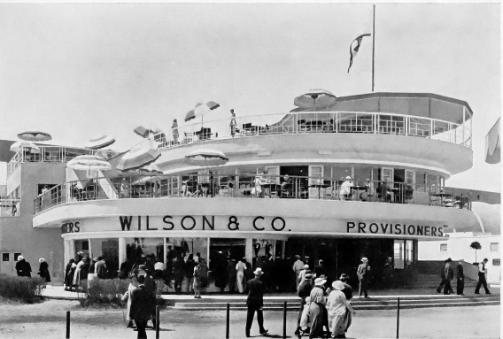
The 1933-34 Chicago Worlds Fair Wilson Exhibit Building.


Wilson & Co. extends a cordial invitation to all its customers and friends to see the Wilson  & Co. Exhibit Building on Northerly Island, in the heart of the Midway at A Century of Progress.
The Wilson & Co. Certified Bacon Slicing Exhibit is slicing and packing continuously from 11:00 am to 11:00 pm in this beautiful modern exhibit at the 1933/34 Chicago World's Fair, A Century of Progress.


Unique in the history of the Meat Packing Industry, a complete Bacon Slicing Room is in continuous operation in this beautifully designed building. Lovely girls in trim uniforms slice and pack 8,000 pounds of Certified Bacon daily under the same sanitary conditions found in all Wilson & Co. plants. During the 329 days the fair was open in 1933/34, 2,632,000 pounds of Bacon was sliced.

The picture above represents the Wilson deluxe Certified Sliced Bacon room in full operation on the first floor of our Exhibit Building. The giant slicer cuts 400 slices each and every minute. Girls are packing these slices of Certified Bacon with chrome tongs. No human hand touches Certified Bacon until it reaches the homes of consumers.

This room is glass enclosed and kept at a uniform temperature of 55° F. The same degree of efficiency and cleanliness is maintained in this Certified Bacon Slicing Room as is in effect in every one of Wilson & Co. plants in the United States. Wilson's Certified Sliced Bacon is Wilson Selected, Government Inspected, and Quality Controlled. It is the finest Bacon that science can produce. Millions of housewives take great pride in serving Wilson's Certified Bacon at their tables, and dealers everywhere are as proud to handle a product of exceptional quality and goodness.

Arranged around the Certified Bacon Slicing Room corridors are the interesting and instructive exhibits of all Wilson & Co. by-products, from soap to sporting goods and hair insulation.

The Wilson Terrace Restaurant and Roof Garden Restaurant are found on the second and third floors, where wholesome, satisfying plate lunches or steaks can be had at moderate prices.
The Wilson Terrace and Roof Garden Restaurants, Partial Menu.
$1.25 in 1933 Equals $29.00 in 2023.


Wilson & Co. had 10 Food Stands and the Wilson & Co. Stables at the World's Fair.
True lovers of horses will delight in the beauty of this prize-winning six-horse Clydesdale team. They participate in the "Wings of a Century" Pageant daily and are also on exhibition in their own Wilson & Co. stables on the fairgrounds.


History of Wilson & Company, 4100 South Ashland Avenue, Chicago, Illinois.
Wilson & Co. evolved over the years to adapt to a changing market and changing leadership. The business began in 1916 when founder Thomas Edward Wilson took control of the Chicago meat packinghouse Sulzberger & Sons Co. and rebranded it as Wilson & Company. 

By 1917, the Company ranked as one of the 50 largest industrial corporations in the United States and continued to employ thousands of workers at its plant in Chicago until the 1950s.


From its inception, Wilson & Co. has been noted for its progressive policies and efficient methods of operation. It has built an enviable reputation for efficiency of service, integrity, and high business ideals, and the same cardinal company characteristics have been instilled into all of its thousands of employees. 

Wilson & Co. held several subsidiaries that utilized animal by-products to manufacture sporting goods, pharmaceuticals, and industrial chemicals. Ashland Manufacturing ─ a subsidiary of Sulzberger & Sons Co. established in 1913 ─ manufactured athletic gear under the Thomas E. Wilson brand and became Wilson Sporting Goods in 1931.

The Company's headquarters are in Chicago, with other plants and branch houses throughout the United States, Canada and Europe. In 1916, Mr. Wilson founded the Company, heading it until 1934, when his son, Edward F. Wilson, succeeded him. The elder, Mr. Wilson, was then elected chairman of the Board.
Wilson & Co. full-page advertisement for "Wilson's Certified Brand Catsup and Chili Sauce," 1918.


Wilson's meat-packing plants are located in Chicago, Kansas City, Los Angeles, Oklahoma City, New York City, Albert Lea, Minnesota, Cedar Rapids, Iowa, and Nebraska City, Nebraska. Wilson & Co.'s Butter and Cheese factories are located at Abilene, Lubbock and Amarillo, Texas; Wichita, Kansas, Altus, Oklahoma City, Blackwell and McAlester, Oklahoma; Ottumwa, Cedar Rapids, Eagle Grove and Reinbeck, Iowa; Dixon and Lanark, Illinois.

The Company has upwards of 90 branch houses in the United States, in addition to the plants as mentioned above, and has branches, subsidiaries and agents in the United Kingdom, Norway, Sweden, and Denmark, as well as at other points in Continental Europe, Mediterranean Countries, South America, Central America, the West Indies, Mexico, Canada and Newfoundland, China, the Canary Islands, Singapore, Bangkok, Siam, Manila, and Batavia. There are approximately 25,000 persons employed by the Company, of which upwards of 1,000 are salesmen.

Mr. Thomas E. Wilson is a notably outstanding figure in the meat packing industry. In addition to making many valuable and constructive contributions to the industry, he was the founder of the Institute of American Meat Packers and its first president.

Timeline of Wilson & Company
March 22, 1916 - Thomas Edward Wilson is named President of the Chicago meatpacking firm Sulzberger & Sons Co. after banks force a change of management. Sulzberger & Sons had been accused of German sympathies when a shipment of meat was intercepted by a British blockade.

July 21, 1916 - Sulzberger & Sons Co. is renamed Wilson & Co.

Ashland Manufacturing – a subsidiary manufacturing athletic gear – is renamed Thomas E. Wilson & Co.

1917 - Wilson & Co. ranked as one of the 50 largest industrial corporations in the United States.

1927 - Thomas E. Wilson’s son, Edward Foss Wilson, enters the family business, starting in the stockyards.

1931 - Edward Foss Wilson named Vice President of Wilson & Co.

Subsidiary Thomas E. Wilson & Co. is renamed Wilson Sporting Goods.

1933/34 Wilson & Co. shows at the Chicago Century of Progress World's Fair. 

February 27, 1934 - Edward Foss Wilson is named President of Wilson & Co., and Thomas E. Wilson becomes Chairman of the Board.

1953 - Edward Foss Wilson becomes Chairman of the Board of Wilson & Co.

January 5, 1967 - Wilson & Co. is acquired by Ling-Temco-Vought, Inc., and its headquarters are transferred from Chicago, Illinois, to Dallas, Texas.

Ling-Temco-Vought reorganizes the company into three publicly-traded divisions: Wilson & Co. Inc. (meat), Wilson Sporting Goods Co., and Wilson Pharmaceutical & Chemical Corp.

1969 - Wilson Pharmaceutical & Chemical sold to American Can.

1970 - Wilson Sporting Goods is acquired by PepsiCo.

1976 - Wilson & Co. is renamed Wilson Foods Corporation.

1981 - LTV Corporation (Ling-Temco-Vought) divests itself of Wilson Foods.

1988 - Wilson Foods is acquired by Doskocil Companies, Inc.

1989 - Amer Group of Finland (later Amer Sports Oyi) acquires Wilson Sporting Goods.

1990 - Doskocil files for Chapter 11 bankruptcy and sells off Wilson Brands division.

1995 - Doskocil changes its name to Foodbrands America, Inc.

1997 - IBP, Inc. acquires Foodbrands America, Inc. (including Wilson Foods).

2001 - Tyson Foods acquires IBP, Inc. (along with remaining Wilson meat brands).

2018 - A Chinese investor group led by Anta Sports Products acquires a majority stake in Amer Sports Oyj.

Compiled by Dr. Neil Gale, Ph.D. 

Thursday, October 20, 2022

The Midget Club at 4016 West 63rd Street, Chicago. (1948-1982)

The Midget [1] Club bar was owned by Chicago native Parnell St. Aubin, who’d played a Munchkin soldier in The Wizard of Oz. His wife, Mary Ellen Burbach, was a former Mae West impersonator with the vaudeville troupes Rose’s Parisian Midget Follies. Mary also performed with: Fred Roper & His Wonderful Midgets, Henry & Dolly Kramer Midget Troupe, and Nate Eagle’s Hollywood Midgets.

In 1934, at Chicago’s World Fair, ‘A Century of Progress,’ Mary was part of the cast of ‘Midget City,’ “a colony of Lilliputians, living in miniature houses, furnished with tiny furniture.” A year earlier, Parnell had appeared in the same Midget Village, playing ‘Little Elmer,’ the smallest Midget at the fair. Both shows cost 25¢ to enter.
1933 Chicago World Fair, Midget Village.


Eyes center on dainty Stella Royal performing in an outdoor theatre in the Midget Village, Century of Progress, Chicago, 1933.


The couple met in the Toy Department of Chicago’s State Street Goldblatt’s Department Store in 1932, where Mary Ellen worked as one of Santa’s elves during Christmas. 

Parnell had come to see the little people at Goldblatt’s. When Parnell laid eyes on Mary, attention was swift and mutual. They got engaged on St. Valentine’s Day, February 14, 1933, 49 days after their first meeting. Mary and Parnell were married on Tuesday, April 4, 1933.

And then came the bar. “We created the bar to fit our size,” said Mary in 2008. “It was custom-built. Pint-size, so we could easily maneuver around, tend bar and serve customers.”

The Chicago Reader recalls: “The club was built for people of small stature: the stools were miniature, and the pay phone was installed just feet above the floor. St. Aubin, who was three-foot-seven, would climb up on a stool to reach the cash register. A large mural of Munchkins marching along the yellow brick road was painted behind the bar.”
The Midget Club


Richard Reeder was 16 when he first visited the bar, delivering supplies for his uncle’s company, Veteran Supply, in 1962. “It blew my mind,” he recalls. “I remember photos of St. Aubin with Judy Garland and Ray Bolger. It was just so out of context and, like Oz, a place of wonder and fantasy.”

The bar welcomed patrons of any height, and they did not discriminate. “If I depended on the midget trade, Parnell said, “I’d starve.”

After Parnell died on December 4, 1987, Mary kept the Oz theme alive, becoming First Lady of the Oz Festival, an annual tribute event in Chesterton, Indiana.

Compiled by Dr. Neil Gale, Ph.D.


[1] Midget (from midge, a tiny biting insect) refers to a very short but normally proportioned person. While not a medical term, it has been applied to people of short stature, often with dwarfism. The word Midget has a history of association with the performance arts as little people were often employed by acts in the circus, vaudeville, etc. The term midget is now rarely used and is considered offensive. But its usage was very common until the end of the 20th century. 

"Dwarf" refers to an extremely short adult who is 4 feet 10 inches tall. The average adult height in dwarfism is four feet. Common complications include bowing of the legs, hunching of the back, and crowded teeth.

Saturday, May 7, 2022

Ora Snyder, Chicago's Candy Queen.

Since the late 1800s, Chicago was known as the "candy capital of the world."

Chicago has many ties to the chocolate industry. Charles "Carl" Frederick Günther, known as "The Candy Man," opened his own candy factory and store at 125 South Clark Street in Chicago in 1868. He originated and introduced caramels, a staple product of most candy factories ever since.

The World's Columbian Exposition of 1893 featured a chocolate pavilion, a cocoa mill, a 38-ft. chocolate statue, and German chocolate-processing machines on display and available for sale. Milton Hershey purchased one of these chocolate-making machines and used it to make chocolate back in his home state of Pennsylvania. The first Hershey bar was produced in 1900. Hershey's Kisses were developed in 1907, and the Hershey Bar with almonds was introduced in 1908.

By the early 1900s, Chicago was home to over one thousand candy companies. The National Confectionery Association and The Manufacturing Confectioner magazine were founded in Chicago.

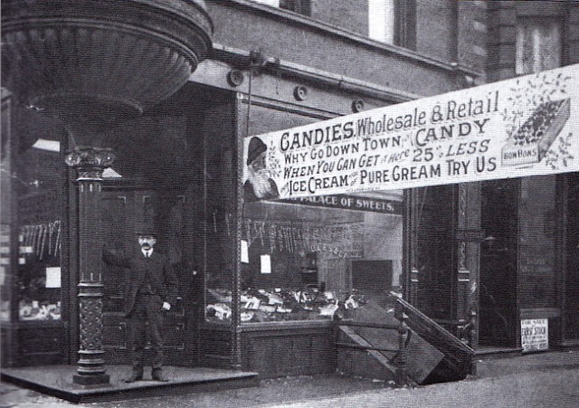
Emil J. Brach opened “Brach's Palace of Sweets” on North Avenue and Halsted Street in Chicago in 1904 and sold mainly chocolate bars and an almond nougat confection. After World War II, Brach's had more than 1,700 product lines.
Brach’s Confections, "Brach's Palace of Sweets," Chicago.
Johnson’s Candy Company developed Turtles candy in 1918 when a traveling salesman showed a piece of candy to one of the chocolate dippers because it looked like a turtle. In 1923, the candy maker’s stores dropped the "Johnson’s" name and was renamed DeMet’s, Inc., located at 177 North Franklin Street, Chicago. DeMet’s immediately trademarked the name "Turtles."
The first Fannie May candy shop was opened at 11 North LaSalle Street in 1920 by H. Teller Archibald, a prominent Chicago racehorse owner. The business was booming—by 1935, it had grown to 48 retail shops in Illinois and surrounding Midwest states. Key to the company’s success was its collection of decades-old candy recipes that, over the years, it refused to update or modernize. In 1946, Fannie May created “Pixies,” their most popular product. Since 2017 the company is currently owned by "Ferrero SpA" in Italy.
The first Fannie May Candies store opened in 1920 at 11 North LaSalle Street in Chicago.


Ferrara Pan, a Chicago-based company’s claim to fame, was the introduction of Bit O’ Honey in 1924, a honey-flavored taffy product with bits of almond embedded throughout. 
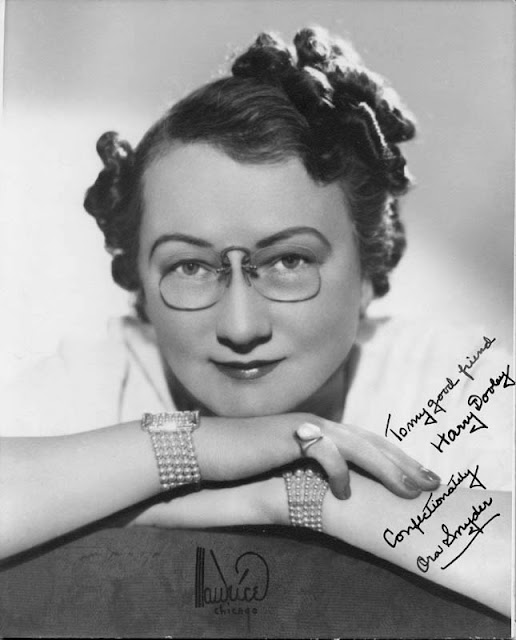
Aurora “Ora” Henrietta Hanson was born in 1876 in Michigan City, Indiana. When she achieved renown as a businesswoman, her origin story appeared in dozens of newspaper and magazine articles: her mother died when she was 3 years old, leaving her and her siblings with their sea captain father. Not allowed to have store-bought candy, young Ora learned to make confections for the family.
Aurora “Ora” Henrietta (Hanson) Snyder.
She married William Allen Snyder in 1894 and had one daughter, Edith. In 1909, William became ill, leaving Ora to consider how she might support the family should he not survive. She got to work making candy at home to sell at a local school, and her reputation grew enough to seek out other opportunities to sell her candy in Chicago. In 1910, she rented a nine-foot-wide store in the Hamilton Club Building.

From the start, Snyder’s business model came from her personal experience: people buy what they like. She focused less on her competitors and more on who her customers were and what they wanted. She gave out free samples to entice sales.

Another keen observation was that men bought more candy than women and preferred chewier and saltier varieties. She expanded her commercial ventures by opening new shops, not in shopping districts but in male-dominated business areas such as the Board of Trade Building.
Mrs. Snyder’s Homemade Candies Brochure.
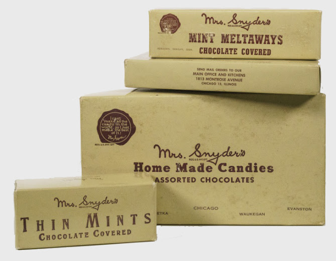
Mrs. Snyder marketed her brand to emphasize that she was a real person who cared about quality and her customers. Framed photographs of her hung in each shop with the message “Mrs. Snyder thanks you.” Early on, she recognized the benefits of pre-packaged candies and intentionally developed no-frills packaging.
Mrs. Snyder’s candy boxes bear her seal of approval and the words, “I can’t make all the candy in the world, so I just make the best of it!”


By the early 1920s, Mrs. Snyder’s had expanded to five locations, including a seven-story building at 119-21 North Wabash Avenue.
Vintage candy tin from Mrs. Snyder's Candy Shops. The tin features a Noblewoman being serenaded by the court musician.

In addition to her business, Snyder helped found the Associated Retail Confectioners of the United States, serving as their President between 1930 and 1932. She was also a Chicago Business and Professional Woman’s Club member and regularly gave speeches to similar groups.

By 1932, Mrs. Snyder's Candies had eleven downtown stores:
  • 2030 East 71st Street, Chicago.
  • 20 South Dearborn Street, Chicago.
  • 61 West Jackson Boulevard, Chicago.
  • 8 South LaSalle Street, Chicago.
  • 331 South LaSalle Street, Chicago.
  • 222 West Merchandise Mart Plaza, Chicago.
  • 406 South Michigan Avenue, Chicago.
  • 218 South Michigan Avenue, Chicago.
  • 1813 West Montrose Avenue, Chicago, IL. (H.Q. & Kitchens)
  • 65 West Randolph Street, Chicago.
  • 119-21 North Wabash Avenue, Chicago.
  • 130 South Wabash Avenue, Chicago.
  • 79 West Washington Street, Chicago.
  • 104 North Oak Park Avenue, Oak Park, IL.
  • 716 Church Street, Evanston, IL.
  • 1739 West Howard Street, Evanston, IL.
Ora Snyder's business instincts kicked in when she set up five shops at the Century of Progress International Exposition for the fair's second year in 1934. One was on the western approach to the 23rd Street bridge, and the four other shops were on the south of the wide promenade connecting the mainland with Northerly Island, just east of the Streets of Paris. 


Each store featured a candy kitchen in full operation, separated by large plate glass windows for visitor viewing. The favorite feature of the stores was the cutting-edge air conditioning and an ice cream machine. Air conditioning was still a novel feature in 1934, and it drew large crowds seeking relief from the summer heat, but it also kept the candy from melting and the workers from heatstroke.
Shoppers at Mrs. Snyder's Candy Shop on South Michigan Avenue, Chicago. 1927


Soon after, newspaper headlines announced, “Mrs. Snyder Decides to Air Condition all of her Stores” after her success at the World's Fair.
Ora Snyder (far right) built a candy empire earning the monicker "Chicago's Candy Queen."


Ora Snyder continued to be active in the business until 1947, when she stepped down as head of her company due to illness. She died in Chicago in 1948 at 72, leaving behind sixteen shops in the Chicagoland area and hundreds of employees.

William Snyder served as Chairman of the Board for Mrs. Snyder’s until he died in 1955. The business remained in the family with son-in-law Seymour W. Neill and grandson William J. Neill until it became part of Fannie May in 1967.  


Compiled by Dr. Neil Gale, Ph.D.

Monday, November 18, 2019

An Examination of the Birth of Chicago.


In historical writing and analysis, PRESENTISM introduces present-day ideas and perspectives into depictions or interpretations of the past. Presentism is a form of cultural bias that creates a distorted understanding of the subject matter. Reading modern notions of morality into the past is committing the error of presentism. Historical accounts are written by people and can be slanted, so I try my hardest to present fact-based and well-researched articles.

Facts don't require one's approval or acceptance.

I present [PG-13] articles without regard to race, color, political party, or religious beliefs, including Atheism, national origin, citizenship status, gender, LGBTQ+ status, disability, military status, or educational level. What I present are facts — NOT Alternative Facts — about the subject. You won't find articles or readers' comments that spread rumors, lies, hateful statements, and people instigating arguments or fights.

FOR HISTORICAL CLARITY
When I write about the INDIGENOUS PEOPLE, I follow this historical terminology:
  • The use of old commonly used terms, disrespectful today, i.e., REDMAN or REDMEN, SAVAGES, and HALF-BREED are explained in this article.
Writing about AFRICAN-AMERICAN history, I follow these race terms:
  • "NEGRO" was the term used until the mid-1960s.
  • "BLACK" started being used in the mid-1960s.
  • "AFRICAN-AMERICAN" [Afro-American] began usage in the late 1980s.

— PLEASE PRACTICE HISTORICISM 
THE INTERPRETATION OF THE PAST IN ITS OWN CONTEXT.


The growth of modern (Chicagoua) Chicago since its first beginnings has resulted in much bewilderment over the decades. Seldom has a great city arisen amid natural surroundings more unpromising than those afforded by the site of primitive Chicago.

The sluggish river slipped into the lake over a sandbar that effectually blocked the vessel entrance, and nowhere within a hundred miles could shipping find shelter from the storms, which raged with peculiar violence at this end of Lake Michigan. A few miles to the west ran a continental watershed but only a few feet in depth. The river itself commonly ran with no perceptible current, and to the horizon limit, the landscape stretched in one monotonous level of flat uniformity. The prairie at certain seasons of the year was entrancing, but the melting snows of spring or heavy rain at any time transformed it into a vast, shallow lake, over which the canoe of the Indian or the occasional bateau of the fur-trader plied its way regardless of the course of the river.

The consequences of such an environment from the viewpoint of human occupation are sufficiently obvious. During much of the year, early Chicago presented all of the attributes of a first-class marsh. Nothing was done about drainage until the townsmen in 1858, by a magnificent exercise of willpower and energy, raised Chicago out of the mud from the morass it had been built up to its present level. As for highways, during the dry periods in summer, one might travel anywhere over the prairie sod, which afforded an excellent footing for horses. In spring and autumn, however, and after rain, at any time, the road quickly turned to a bottomless sea of mud, the despair of all who were compelled to traverse it. It's no wonder that pioneers were fond of recalling that they had come through Chicago on their journey west and that they "wouldn't take a quarter section there as a gift."

From his particular point of view, the pioneer farmer was correct in his judgment, yet a wider knowledge would have shown him that nature had marked the site of early Chicago as the spot where a great city should arise. Cities are the offspring of commerce, and they commonly develop at points on the highways of traffic where a break in transportation occurs. Even a slight familiarity with the physiography of the continent's interior, combined with a knowledge of the workings of economic law, would have sufficed to assure the observer of the future destiny of Chicago. How the matter presented itself to the minds of far-sighted contemporary observers is revealed in the story of Arthur Bronson and Charles Butler, who first visited the place in the summer of 1833.
Chicago in 1833
CLICK TO VIEW A FULL-SIZE MAP
Bronson and Butler were two shrewd businessmen from New York whose attention had been directed to the Western country by the events of the Black Hawk War. They concluded to investigate the situation with a view to possible investments, and their attention was directed to Chicago by no less than General Winfield Scott [1], whose unhappy experiences there the preceding summer had not blinded him to the future promise of the place. On their arrival in August of 1833, they found a village of about two hundred people in the early flush of its first real boom, "infested" by thousands of Indians gathered for the impending council of peace with the Great Father (President of the United States). 

To the northeast lay the territory of Michigan, with a population of 20,000 souls, most of whom gathered near Detroit. The northern half of Indiana contained only a few scattered settlers, while between Lake Michigan and the Mississippi stretched a vast unoccupied expanse of land, covered with luxurious vegetation, beautiful to look at in its virgin State, and ready for the farmer's plow. "One could not fail," wrote Butler at a later time, "to be greatly impressed with this scene, so new and extraordinary, and to see there the potential of that future when these vast plains would be occupied and cultivated, yielding their abundant products of human food, and sustaining millions of population. Lake Michigan lay there, 420 miles in length, north to south. It was clear to my mind that the productions of that vast country lying west and Northwest of it on their way to the eastern market, the great Atlantic seaboard, would necessarily be tributary to Chicago, in the site of which even at this early day the experienced observer saw the possibility of a city destined from its position near the head of the lake and its great harbor formed by the river, to become the largest commercial emporium of the United States." 

The foresight of these men found an adequate reward, both of them reaping fortunes within a few years from their investments in Chicago real estate. Since the world had as yet no comprehension of the astonishing era of iron-horse (railroad) development that lay immediately at hand, this early forecast of Chicago's future was uninfluenced by any knowledge of the factor that has contributed most to the city's greatness. They were aware, however, of that other factor so potent in the upbuilding of Chicago, its location on nature's great central thoroughfare between the waters of the Great Lakes and those of the Mississippi River system.

Chicago's prosperity and possibilities of future growth have been conditioned by the character and extent of her highway systems at every period of her existence as a city. These have been threefold, comprising waterways, country thoroughfares, and railroads. The channels come first in point of time, if not of present importance, and some consideration of them necessarily enters into every discussion of the origin of Chicago.

Indeed, it is no exaggeration to say that Chicago owes its very existence to its strategic location on one of North America's most critical water routes. It was no mere chance that led the first white man who ever explored the upper Mississippi Valley to the site of the future Chicago. In the primitive State of the country, the waterways possessed importance unknown to the present generation. The Chicago-Illinois River route constituted one of the natural thoroughfares leading from the St. Lawrence River system to the Mississippi, and the Chicago Portage was one of the five great "keys of the continent." So low is the continental divide at this point that in times of spring floods or heavy rains, it was frequently covered with water, and the Des Plaines River at such times discharged through the south branch of the Chicago River into Lake Michigan, as well as down its normal channel. This was rectified in 1887, a novel in human history, by reversing the flow of the Chicago River, thereby sending the city's sewage down the Illinois River instead of into Lake Michigan, where its water supply is drawn.

Under such physiographical conditions, it is not surprising that the first explorer who ever visited this region conceived the idea of connecting Lake Michigan with the navigable waters of the Illinois River. With statesmanly precision, Louis Jolliet, in 1673, called his government's attention to the advantages of cutting a canal across the Chicago Portage. His hasty tour of observation afforded him no adequate conception of the difficulty and magnitude of the improvement proposed. Still, his vision was transmitted to posterity and almost two centuries later found realization.

From the first entrance of the American government into the Northwest, its officials understood the strategic importance of the Chicago-Illinois waterway. When in 1794, Anthony Wayne broke the power of the northwestern tribesmen in the battle of Fallen Timbers, a portion of the price of victory extorted from them in the ensuing treaty of Greenville was the unrestricted use of this highway and the cession of reservations at Chicago, Peoria, and the mouth of the Illinois River on which forts might be erected to safeguard it.

A beginning was made to this end with Fort Dearborn's construction at the Chicago River's mouth in 1803. The purchase of Louisiana from France in the same year gave the Illinois River route added importance for the United States. Down it in the spring of 1805 came Colonel Kingsbury with a company of troops from distant Mackinac to establish Fort Bellefontaine opposite the mouth of the Illinois River, and Fort Dearborn thereupon became a link in a chain of outposts set to guard the frontier against Mackinac to the Gulf of Mexico.

The Illinois and Michigan Canal is peculiar among the improvements of this character. In the fact that during the early years of agitation of the project, no local constituency was concerned with it. On the contrary, it was visioned as a work of national interest and importance long before the territory of Illinois had acquired a corporate existence. The exertions made by General Wayne during Washington's administration to acquire control of the Illinois waterway have already been noted. Following the acquisition of Louisiana in 1803, the vision gradually dawned upon the country of connecting New York with New Orleans by one grand continuous internal waterway. To do this, the Hudson must be connected with Lake Erie and Lake Michigan with the Illinois River.

The commercial demand for such a work was slight. The disasters on land encountered in the War of 1812 served to emphasize anew the military importance of a safe and practicable highway from the Great Lakes to the Mississippi River. In concluding treaties of peace with the Northwestern tribes at the close of the war with England, the opportunity was improved to secure for the United States a strip of land between Lake Michigan and the Illinois River through which the future canal must be built. Investigations of the route by army engineers quickly followed. In January of 1819, John C. Calhoun, as secretary of war, submitted a report to Congress urging the construction of a canal across the Chicago Portage.

Meanwhile, Illinois had been admitted to statehood in 1818. Contrary to the evident design of the framers of the Ordinance of 1787, its northern boundary had been advanced from the "southerly bend" of Lake Michigan to the line of 42° 30', with the avowed purpose of giving the new State a northern trend through the possession of a commercial outlet on Lake Michigan. Through this maneuver, local interest in forwarding the construction of the canal was created, and from this time forward until success crowned the enterprise thirty years later, local zeal and enthusiasm for the work took precedence over national interests. 
To the canal project, the birth of Chicago as a corporate entity was directly due. In 1827 Congress granted to the State the alternate sections of land in a five-mile strip along either side of the canal for the purpose of aiding its construction. After some delay, the state legislature in 1829 made provision for a canal commission of three members, with powers appropriate for the work in view. This commission proceeded to lay out the towns of Chicago and Ottawa at either end of the proposed route, and in the summer of 1830, the lots at Chicago were offered at auction to the public.

Under the sheltering walls of Fort Dearborn, a tiny settlement had gradually developed composed of civilian government employees, the families of discharged soldiers, and the establishments of the fur traders. Many of the settlers were Frenchmen who had taken married Indian wives or were themselves the offspring of such alliances on the part of an earlier generation. It is impossible to determine this civilian community's precise population at any given time, but its approximate size and importance are clear. As early as the spring of 1812, when the Indians murdered two of its members on the South Branch of the Chicago River, Captain Heald was able to enroll a force of "Chicago militia" fifteen in number from the residents of the settlement without the fort. A fate as tragic as any in our military annals shortly befell this pioneering body of Chicago's soldiery. Three of them deserted to the Indians, indicating their greater affiliation with that race by this act, while the loyal twelve remaining perished in the Fort Dearborn Massacre of August 15, 1812.

A new Fort Dearborn arose from the ashes of the old in the summer of 1816, and contemporaneously therewith, a second civilian settlement began to develop outside the fort. At the time of the Winnebago trouble in 1827, a second Chicago militia company was mustered, but its history, unlike that of its predecessor, is wholly comic. The fire that destroyed the Fort Dearborn barracks at this time is said by a contemporary to have been witnessed by about forty spectators; their number Included every person then present in the community. By 1830 the population was probably upwards of three or four scores (a score equals 20).

The habitations of the settlement had been built at the forks of the river and along the mainstream running eastward to the military reservation and into Lake Michigan. This territory was part of Section Nine of the United States land survey, one of the alternate sections that had fallen to the Canal Commission by a congressional grant. In modern terminology, this section extended from State Street West to Halsted and from Madison North to Chicago Avenue. On it, the surveyor employed by the commission, James Thompson, proceeded to lay out the town plat. Still, since considerably more than half of the section lies north of the river, he chose to play only that portion of it extending northward from Madison to Kinzie streets and westward from State to Des Plaines. Within this area of about three-eighths of a square mile, forty-eight blocks and fractional blocks were laid out on the familiar checkerboard plan with parallel streets running north and south and east and west, the only irregularities being such as were rendered unavoidable by the course of the river. East of the town plat, between State Street and the lake, south of the river, lay the Fort Dearborn reservation and north of it a fractional quarter-section which was entered the next year by Robert Kinzie on behalf of the heirs of his father, John Kinzie, the old Chicago trader. With the exception of Canal, Market, and Lake, and the several Water streets, the derivation of which is sufficiently obvious, Surveyor Thompson named his streets in honor of national or local characters. Washington, Randolph, Lake, South Water, Carroll, and Kinzie ran east and west. North and south streets were Dearborn, Clark, Market, East Water, West Water, Canal, Clinton, and Jefferson.
The survey was completed, and the town plat was filed for record on August 4, 1830, which may be taken as the first definite date in Chicago's corporate history. The public land sale held the following month developed only moderate enthusiasm on the part of bidders over the question of real estate values. For 126 lots, an average price of $35 was bid, while two eighty-acre tracts lying just beyond the limits of the town plat went for $1.25 ($59.50 today) an acre, and another similar tract for a few cents more. Many of the purchasers were residents of the place who were simply buying in their homes, which had been built on land to which they had no legal title. Aside from these, the purchasers, whether residents or outsiders, were evidently actuated by speculative considerations.

There is little to indicate that those most familiar with Chicago had any inkling of the revolution in real estate values that was soon to be witnessed here. A delightful story in this connection is preserved by Mrs. Juliette Augusta Magill Kinzie. [John H. Kinzie's wife]. A few months after the land sale of 1830, roused by such developments as had already taken place, Robert Allen Kinzie (1810-1873) journeyed to the land office at Palestine in Crawford County, Illinois. On behalf of the Kinzie family, they entered the fractional quarter-section lying north of the Chicago River and east of State Street, which included the old Kinzie home.
The Kinzie Mansion. The House in the background is that of Antoine Ouilmette. Illustration from 1827.


Successive owners and occupants of the Kinzie Mansion:
  • Jean Baptiste Pointe de Sable: circa 1796, fur trader/farmer. Moved from his 1790 farm on the Guarie River [1] (the north branch of the Chicago River). He departs Chicago in 1800.
  • Jean Baptiste La Lime: 1800-1803, owner {{a careful reading of the Pointe de Sable-La Lime sales contract indicates that William Burnett was not just signing as a witness, but also financed 100% of the transaction, therefore being the owner}}.
  • Dr. William C. Smith with Jean Baptiste La Lime: 1803. (Kinzie forced Métis[2] Jean La Lime to relinquish De Sable's large house, which he then occupied with his family. When La Lime protested the loss of his property, Kinzie first quarreled with the man and then killed La Lime.)
  • John Kinzie's Family: 1804-1828 (except during 1812-1816).
  • Widow Leigh & Mr. Des Pins: 1812-1816.
  • Anson Taylor: 1829-1831 (residence and store).
  • Dr. E.D. Harmon: 1831 (residence & medical practice).
  • Jonathan N. Bailey: 1831 (residence/post office).
  • Mark Noble, Sr.: 1831-1832.
  • Judge Richard Young: 1832 (circuit court sessions).
  • Unoccupied and decaying in 1832.
  • Nonexistent by 1835.
The tract, lying in the angle formed by the river and the lake, comprised but 102 acres instead of the full quarter-section which a claimant was entitled to enter. Kinzie, who might have entered 58 additional acres elsewhere, returned home without troubling himself to do so. On learning of this, his mother urged him to claim the cornfield at the river forks. Although Kinzie was a businessman, his response to her argument was a hearty laugh. "Hear mother," he said, "we have just got 102 acres, more than we should ever want or know what to do with, and now she would have me go and claim 58 acres more!"

The additional acreage was not claimed because, in the judgment of this man, who had spent his entire life at Chicago, it would be a mere waste of effort to do so. That he was not alone in his inability to see the future that Chicago held in-store may be seen from a comparison of the prices paid at the sale of 1830 for certain tracts of land with the value of the same tracts twenty-three years later. Thus, the eighty acres that Thomas Hartzell acquired for $124 in 1830 might have been sold for $800,000 in 1853. James Kinzie's (son of John Kinzie and his first wife Margaret McKenzie) eighty acres, purchased for $140, were valued at $600,000 at a later date. The lot for which William Jewett, in his excitement, parted with $21 at the land sale of 1830, if retained until 1853, would have netted him $17,000, while John H. Kinzie's (eldest son of John and Eleanor Kinzie) larger investment of $119 multiplied itself in the same period to $163,000.

These figures imply a great growth spurt in population and a corresponding increase in commercial importance. For the first few years, however, the growth was exceedingly slow, and the speculators of 1830 may well have bemoaned, during this period, their recklessness in parting with good money in return for titles to town lots in the wilderness.

The season of 1831 witnessed little outward change at Chicago, which continued to present the aspect of a village of log huts, with not a single frame structure in the place. Yet the season was marked by two occurrences significant to the trend of future events. Several settlers passed through the town, intent on finding homes in the valleys of the Des Plaines River and the DuPage River; Cook County was created by legislative enactment, and Chicago became the county seat.

The season of 1832 was in every way abnormal. With the spring came the panic occasioned by the incursion of Black Hawk's warriors into Illinois. Fort Dearborn had been without a garrison since May of 1831, but its walls afforded the only shelter available to the Des Plaines River and DuPage River settlers, and to Chicago, they fled in wildest terror. The normal population of perhaps 100 persons was quickly swelled to five times this number, and the confusion and crowding were intensified by the arrival of detachments of Michigan militia and regular soldiers. Housing accommodations were strained to the utmost in the effort to shelter the fugitives, and even the food supply soon became inadequate for the sustenance of the multitude that had so suddenly assembled.

In July of 1832 came General Winfield Scott, bringing several hundred soldiers from the East to the scene of the Indian War. With Scott came Asiatic cholera, and at the news of its approach, the Indian peril was forgotten. Townsmen and settlers alike took sudden flight before the dread presence, and overnight, as it were, Chicago was emptied of its civilian population. Only those remained who were compelled by the stern demands of duty. For weeks, the place was but a military lazaret (a building set apart for quarantine purposes) whose occupants were engaged in fighting the plague and giving hasty burials in the Cholera Cemetery, also known as the Lake and Wabash burial site to those who died from it. 

Before autumn, war and cholera had alike departed. The townsmen returned to their abandoned homes, and life at Chicago resumed once more. Meanwhile, far away from the tiny Fort Dearborn, community events had been prepared, which were shortly to terminate, rudely and forever, Chicago's long slumber. By Wilderness Trails and the National Road, settlers had been pouring over the mountains and down the Ohio River into the Lower West for a generation. The opening of the Erie Canal in 1825 afforded for the first time a practicable highway connecting the settled East with the Great Lakes. Along these trails, it streamed an ever-increasing number of settlers in the ensuing years, taking possession of western New York and northern Ohio and pouring on into the wilderness of southern Michigan and northern Indiana. 

For Chicago, the Indian War had two results exceeding the consequences. It brought about the extinction of the Indian title to the land between Lake Michigan and the Mississippi and the removal of the  Indians farther west. Of equal significance, perhaps, it caused hundreds of men to be taken upon an enforced excursion through the entrancing wilderness of northern Illinois and southern Wisconsin. We have already seen the effect produced upon their minds illustrated in the case of their commander, General Winfield Scott. They returned to their homes carrying marvelous tales of the country's surpassing beauty and of the wealth in forests, mill sites, and farms that awaited the coming of the settler. In hundreds of eastern communities, these reports were absorbed with the keenest interest, and the ambition was kindled in the breasts of the hearers to become sojourners in this new land of promise.

The first wave of the tide of migration into the new Northwest reached Chicago in the spring of 1833. Most of the home seekers passed through the place to find locations farther on. Some, however, attracted by the commercial promise of Chicago, ended their journey here. In either event, they made their contribution to the city's upbuilding, for its growth depended upon the development of its backcountry, and every homestead established in the wilderness west of Lake Michigan involved the addition of another source of tribute to Chicago's permanent prosperity.

At the beginning of 1833, the place was still a village of log huts, the only frame building being the warehouse of businessman George W. Dole, which had been erected the summer before. The season was one of feverish activity, however, and at its close, dozens of new frame buildings might be seen where but one had stood before. To be sure, they were of flimsy construction, hastily thrown together in the cheapest and rudest manner. Still, their presence afforded convincing evidence that a vigorous, throbbing life had replaced the laid-back atmosphere of old at the forks of the Chicago River. 

Building developments aside, the season was marked by two other occurrences of note. A canal implied a harbor for shipping at Chicago. Congress had long since lent its countenance to the canal project, but as yet, there was no harbor because of the sandbar blocking the mouth of the river. In March of 1833, Congress voted $25,000 ($656,350 today) for a harbor at Chicago, and on July 1st, construction began. The river was afforded a direct outlet to the lake by cutting a channel through the sandbar. The work by the army engineers was completed in the spring of 1834 by the Des Plaines River, which sent its spring flood down the Chicago River with such force as to dredge the channel deep enough to permit the entrance of the heaviest vessels. Piers to the north and south of the new river mouth, extending five hundred feet into the lake, completed the work of the engineers, and for the first time, shipping found a safe and adequate harbor at the south end of Lake Michigan.

The other event of importance in the expanding annals of Chicago was its incorporation as a town on August 12, 1833. At a preliminary election held on August 5th to elicit the will of the townsmen on the question, twelve votes had been cast in favor of the measure and only one in opposition. The negative vote was given by a man who lived down the South Branch, several miles away; on what theory he was permitted to participate in the election, contemporaries have neglected to enlighten us. Evidently, the result of the preliminary election was a foregone conclusion, over which the majority of the electorate abstained from wasting valuable time. Far different was it in the election for town trustees, held five days later. The entire electorate, twenty-eight in number, came to the polls, and thirteen of them consented to appear in the role of candidates for office. The state law required at least 150 persons to form a corporate town, and it seems evident from this first election that Chicago's population was dangerously close to the minimum. The arrivals of 1833, however, were probably not eligible to vote.

The council and treaty held with the Potawatomi in the early autumn, one of the most picturesque events in Chicago's annals, brought together, in addition to several thousand  Indians, a motley throng of white men, government officials, fur traders, claimants, speculators, and rogues of varying degree. In October, the sale at auction of the "school section," lying immediately south of the town plat and embracing the land between State and Halsted streets, extending southward from Madison to Roosevelt Road. This area embraces today the greater portion of Chicago's Loop. The intersection of State and Madison streets at its northeast corner is popularly supposed to be the busiest street corner on earth. The land had been subdivided into 144 blocks of approximately four acres each, and these were sold, mostly on credit, at an average price of $6.72 per acre. 

The per-acre price is said by one chronicler to have been "beyond expectations." Although the price paid marks a considerable advance over the $1.25 an acre paid at the land sale of 1830, it is evident that "expectations" were still far from extravagant with respect to Chicago's real estate values. The blocks of the school section were cut up into lots afforded, together with the canal lots in Section 9, the lots on which the speculative craze of 1835 and 1836 originally fed. As the mania grew, however, fresh "additions" were hastily platted and thrown on the market to feed the flame.

A professional economist's task is to expound upon the forces which lead men to embark upon an era of hopeful speculation with its inevitable aftermath of financial stagnation and despondency. Here, it will suffice to note that the middle 1830s saw the development of the wildest land craze the country has ever undergone. At the same time, 1837 ushered in perhaps its severest period of financial depression, commonly known as the Panic of 1837 [2].

At Chicago, the focal point of the Western migration, the speculative mania raged with a peculiar intensity. Throughout 1834, the tide of settlers thronged the town, and under this stimulating influence, signs of a real estate boom became evident. Confined within reasonable bounds, such a movement would have been justified by the substantial facts of the country's economic situation. But with the passing months, legitimate business transactions gave place to frenzied speculation for its own sake. Numerous tales of individual experiences have been handed down to us by contemporaries. Still, the underlying spirit of the time is perhaps best illustrated by the story, reported in the first issue of Milwaukee's first newspaper, of this conversation between two Chicagoans:
"I say," inquired one of the gentlemen, "what did you give for your portrait?" "Twenty-five dollars," was the reply, "and I have been offered fifty for it."
Nor was the speculative mania confined to Chicago real estate. All around the shores of Lake Michigan, on every inlet and creek, and for scores of miles inland, town sites were platted with enthusiastic zeal, and lots in them were bartered with eager abandon at ever-mounting prices. The pioneer historian of La Salle County relates that he set out some small apple trees on his farm and stuck a stake in the ground by each tree to mark the location. A passing stranger soon stopped to inquire about the name of the town he had laid out. On another occasion, he called at a log cabin where half a dozen farmers were assembled. They had evidently been engaged in high speculation throughout the day, for one of them, addressing the newcomer, said with a complacent slap of the thigh, "I have made $10,000 today, and I will make twice as much tomorrow." From further conversation, it developed that he had been the least successful in the entire company.

The pretentious scale of these paper towns may be illustrated in the case of Kankakee City, at the junction of the Des Plaines and Kankakee Rivers. In its prosperous days, this city never contained more than seventy inhabitants. Yet, its promoters had provided ten public squares, with parks and avenues enough to have a fair nucleus for another New York City. The plat, with its many "additions," covered 2,000 acres. In all the prominent centers of real estate speculation, highly ornamented engravings of this city, beautiful with magnificent buildings and busy with the traffic of capacious warehouses and crowded wharves, were on display.

When, in 1837, the bubble burst, it brought ruin to most of those who, for a season, had been reveling in paper fortunes. For many, this meant little loss of real wealth but merely a return to their previous status. An illustration may be seen in the case of John S. Wright, long a useful citizen of Chicago. He first landed here, a penniless boy of nearly seventeen in 1832. Four years later, still a minor, he was worth $200,000. The panic ensued. Wright was unable to meet his extended obligations, and he became penniless in 1832. Some, shrewder or more fortunate than the majority, turned their profits into cash in advance of the collapse. Thus, Arthur Bronson, of whose arrival to Chicago we have already discussed, in the autumn of 1834, bought a tract owned by Captain (afterward General) David Hunter for $20,000. In the spring of 1835, he resold it to his friend, Charles Butler, for $100,000. Butler caused the tract to be subdivided, and by offering it for sale within a month, the entire purchase price was realized from one-third of the lots.

Although the panic brought ruin to numerous individuals and stunted the growth of Chicago for a season, it was of no significance in the tale of the city's ultimate growth. The conditions determining growth cannot be better stated than in Charles Butler's account of the impressions he formed in 1833 concerning the city's destiny. With paper fortunes vanishing like the morning mist, men realized that something more than the art of the lithographer is requisite to the building of a city. After a season of stagnation, they focused anew on the task.

The span of Chicago's existence as a village was four years, from the summer of 1833 to the spring of 1837. In this period, the population increased from about 150 to 4,170. The village fathers entered upon their duties. One of their first public acts was the establishment of a free ferry across the river at Dearborn Street. A donation had been made by the State of certain lots in Section Nine to aid the new town, and a portion of these, set apart for a public square, still remains the seat of county and city government. On this square, the first prison, a log structure, was erected the first autumn, and on August 12, 1833, a code of ordinances for the government of the affairs of the town was adopted. The first financial obligation was incurred in October of 1834 when the sum of sixty dollars was borrowed to drain and otherwise improve State Street. In the autumn of 1836, under the influence of the expansive ideas of the period, a movement was begun to secure from the legislature a charter for a city. It was successful, and on March 4, 1837, the change to the new form of government was made. Although the population was little over 4,000, the corporate limits of the new city were drawn to embrace substantially all of the territories between Twenty-second Street (2200S) and North Avenue (1600N), extending westward from the lake to Wood Street (1800W), an area of ten square miles.

For three years after its incorporation, the city stagnated. Vivid are the recollections that contemporaries have put on record concerning this trying period. Of similar tenor is the evidence afforded by the census statistics of 1840. Only 300 residents had been added to the population in the three-year period. The city now resumed its onward march, and in 1843 the census revealed a population of 7,580, an increase in three years of 3,100, or almost 70%. Three more years saw the population of 1843 practically double, and in the ensuing four years, it doubled again. The census figure of 1850 was 28,269. By 1853, this figure had considerably more than doubled, the three-year increase amounting to 32,400. The next four years saw approximately the same increase, and by 1857, the closing year of the period under review, Chicago had become a city of 93,000 persons.

This figure does not seem particularly impressive in light of recent developments. Yet all human values are relative in their importance, and the significance of the achievement of these two decades in increasing twenty-threefold the population with which the city had started out in 1837 can scarcely be over-emphasized. Thereby, Chicago had become the giant of the Northwest and had stamped the country west of Lake Michigan with the seal of her commercial supremacy.

The explanation of this achievement is not obscure or difficult. Commerce is the lifeblood of an industrial city like Chicago, and the city's highways are the arterial system through which it circulates. Eastward from Chicago stretched the waters of Lake Michigan, affording nine months of the year a natural highway of unlimited capacity. Westward, in the beginning, the highways remained to be created, and it was apparent to all that the city's future depended upon her success in connecting with the backcountry. The work of establishing this connection was begun within a few months after the laying out of the townsite by Surveyor Thompson in 1830. It continued throughout the ensuing years until, in time, a series of radial highways stretched out from the city in all directions, connecting all points that lay within a practicable distance of Chicago. 

To trace in detail the evolution of these highways and describe the life that passed to and fro upon them is covered in my articles: The Green Bay Trail, aka "Old Jambeau Trail," and The Vincennes Trace.

The modern physician places a drop of blood under the microscope and, from the examination of it derives important information with respect to his patient's welfare. Along Chicago's historic highways pulsated the commerce of the time, and from an examination of this traffic, we may draw a remarkably vivid conception of the life of that bygone period. 

Compiled by Dr. Neil Gale, Ph.D.


[1] In 1832, President Andrew Jackson ordered Winfield Scott to Illinois to take command of the Black Hawk War conflict. General Winfield Scott led 1,000 troops to Fort Armstrong to assist the U.S. Army garrison and militia volunteers stationed there. While General Scott's army was en route along the Great Lakes, his troops contracted Asiatic cholera before they left New York; it killed most of his 1,000 soldiers. Only 220 U.S. Army regulars from the original force marched from Fort Dearborn in Chicago to Rock Island, Illinois. Winfield Scott and his troops likely carried the highly contagious disease with them; soon after their arrival at Rock Island, a local cholera epidemic broke out among the whites and Indians around the area of Fort Armstrong. Cholera microbes were spread through sewer-type, contaminated water, which mixed with clean drinking water, brought on by poor sanitation practices of the day. Within eight days, 189 people died and were buried on the island. 

By the time Scott arrived in Illinois, the conflict had come to a close with the army's victory at the Battle of Bad Axe. Also known as the Bad Axe Massacre it was a battle between Sauk (Sac) and Meskwaki (Fox) Indians and United States Army regulars and militia that occurred on August 1st and 2nd of 1832. This final Black Hawk War battle occurred near present-day Victory, Wisconsin.

[2] The Panic of 1837 was a financial crisis or market correction built on a speculative fever in the United States. The end of the Second Bank of the United States had produced a period of runaway inflation. On May 10, 1837, in New York City, every bank began to accept payment only in specie (gold and silver coinage), forcing a dramatic, deflationary backlash. This was based on the assumption by the former president, Andrew Jackson, that the government was selling land for state banknotes of questionable value. The Panic was followed by a seven-year depression, with the failure of banks and then-record-high unemployment levels.