Friday, November 9, 2018

The 1968 Illinois Earthquake, a "New Madrid Fault event," was the largest recorded earthquake in the state of Illinois.

Striking at 11:02 AM on November 9, 1968, it measured 5.4 on the Richter scale. Although there were no fatalities, the event caused considerable structural damage to buildings, including the toppling of chimneys and shaking in Chicago, the region's largest city. The earthquake was among the most widely felt in U.S. history, affecting 23 states over 580,000 square miles.
Isoseismal map for the 1968 Illinois event.
I–III are Not felt; too Weak, IV is Light, V is Moderate, VI is Strong, and VII is Powerful.
In studying its cause, scientists discovered the Cottage Grove Fault in the Southern Illinois Basin. Within the region, millions felt the rupture. Reactions to the earthquake varied: some people near the epicenter did not react to the shaking, while others panicked. A future earthquake in the region is highly likely; in 2005, seismologists and geologists estimated a 90% chance of a magnitude 6–7 tremor before 2055, likely originating in the Wabash Valley seismic zone on the Illinois–Indiana border or the New Madrid fault zone. The first recorded Illinois earthquake was from 1795, when a small earthquake shook the frontier settlement of Kaskaskia.

Data from large earthquakes—in May and July 1909 and November 1968—suggest that earthquakes in the area are of moderate magnitude but can be felt over a large geographical area, mainly because of the lack of fault lines. The May 1909 Aurora earthquake affected people in an area of 500,000 square miles; the 1968 Illinois earthquake was felt by those living in about 580,000 square miles. Contradicting that the region's earthquakes are felt over a wide area, a 1965 shock was only noticed near Tamms, even though it had the same intensity level (VII) as those of 1909 and 1968. Before 1968, earthquakes had been recorded in 1838, 1857, 1876, 1881, 1882, 1883, 1887, 1891, 1903, 1905, 1912, 1917, 1922, 1934, 1939, 1947, 1953, 1955, and 1958. Since 1968, other earthquakes have occurred in the same region in 1972, 1974, 1984, and 2008. 

The quake struck on Saturday, November 9, 1968, at 11:02 AM. The quake's epicenter was slightly northwest of Broughton in Hamilton County and close to the Illinois–Indiana border, about 120 miles east of St. Louis, Missouri. Surrounding the epicenter were several small towns built on flat glacial lake plains and low hills. Scientists described the rupture as "strong". During the quake, the magnitudes of the surface and body waves were measured at 5.2 and 5.54, respectively. The magnitude of the quake reached 5.4 on the Richter scale. The earthquake occurred at a depth of 16 miles. A fault plane solution for the earthquake confirmed two nodal planes (one is always a fault plane, the other an auxiliary plane) striking north-south and dipping approximately 45 degrees to the east and to the west. This faulting suggests dip-slip reverse motion and a horizontal east-west axis of confining stress. At the time of the earthquake, no faults were known in the immediate epicentral region. Still, the motion corresponded to movement along the Wabash Valley Fault System roughly 10 miles east of the area.

The rupture also partly occurred on the New Madrid Fault, which was responsible for the great New Madrid earthquakes in 1812. The New Madrid tremors were the most powerful earthquakes to hit the contiguous United States. Various theories were put forward for the cause of the rupture. Donald Roll, director of seismology at Loyola University Chicago, proposed that the quake was caused by massive amounts of silt deposited by rivers, generating a "seesaw" effect on the plates beneath. "The weight of the silt depressed one end of the block and tipped up the other," he said. However, scientists eventually realized the cause was a then-unknown fault, the Cottage Grove Fault, a small tear in the Earth's rock in the Southern Illinois Basin near Harrisburg, Illinois.
The fault, aligned east-west, is connected to the north-south trending Wabash Valley Fault System at its eastern end. Seismographic mapping completed by geologists revealed monoclines, anticlines, and synclines, all suggesting deformation during the Paleozoic era when strike-slip faulting took place nearby. The fault runs along an ancient Precambrianterrane boundary. It was active mainly in the Late Pennsylvanian and Early Permian epochs around 300 million years ago.

In 2005, scientists determined a 90% probability of a magnitude 6–7 earthquake in the New Madrid area during the next 50 years. This could cause potentially high damage in the Chicago metropolitan area, which has a population of nearly ten million people. Pressure on the fault where the 1811–1812 Madrid earthquakes occurred was believed to be increasing, but a later study by Eric Calais of Purdue University and other experts concluded the land adjacent to the New Madrid fault was moving less than 0.0079 inches a year, increasing the span between expected earthquakes on the fault to 500–1,000 years. Scientists anticipating a future earthquake suggest the Wabash Valley Fault as a possible source, calling it "dangerous." 

Compiled by Dr. Neil Gale, Ph.D.

Sunday, November 4, 2018

Acorn Ridge (Amusement) Park, Lemont, Illinois. (late-1940s-1989)


Acorn Ridge Park (late-1940s-1989) was located at 119th Street and Route 171 in Lemont, adjacent to the Cog Hill Golf Course and near I-55 and I-294.

Acorn Ridge was only open during the summer weekends and the rides operated only on weekends. A number of the rides were trailer mounted, as traveling carnivals use. They had "Pump cars" or hand-cranked cars, a trailer-mounted kiddie coaster, Bumper (7) cars, Hayrides (the park's favorite ride), (2) Arrow 3/4 scale 1906 replica 3-seat antique cars with 10 horsepower Kohler gasoline engine.

LOCATION MAP
I was contacted by R.J., searching for information and photos of this Amusement Park.

R.J. writes, "The most intriguing thing that I recall was that in the late fall, the rides would be tarped and moved to the side, and the grove would fill with actual gypsy wagons, which wintered there. 

I believe the park area was still there into the 80s, although by then, the rides were gone, replaced with many picnic tables.


I would occasionally drive by there to see what had happened to the park and to see if the gypsy wagons ever returned. They didn't, and the park fell into disuse. It was vacant probably until the early 90s and was eventually sold, and it may have been developed into a subdivision."

UPDATED August 16, 2022:
I joined and posted this article in the "Long Time Lemonters," Facebook group. Kelly Orbell Rauch, the granddaughter of Opal Orbell, one of the owners of Acorn Ridge Park, started out with a comment that said, "Who the hell gave these people that information[?]" said Rauch, referring to the personal comment in the article by R.J. 
 
Kelly Orbell Rauch, if you're interested in adding to the article, contact me at LivingHistoryOfIllinois@yahoo.com. 

In the last image in this post, we ask people to HELP expand this amusement park's history with pictures and stories. I'm also more than happy to discuss any issues people have with the data or pictures, but please, don't be aggressive out of the gate because there's nowhere to go from there. 

Compiled by Dr. Neil Gale, Ph.D. 


Below are photographs of Acorn Ridge Park, 1989.
Allen Herschell "Little Beauty" Merry-Go-Round; 2-abreast with (20) wood body, metal leg (1/2 & 1/2) horses and (3) kiddie ponies.
Sellner Tilt-A-Whirl
Eli № 10 Ferris Wheel

Thursday, November 1, 2018

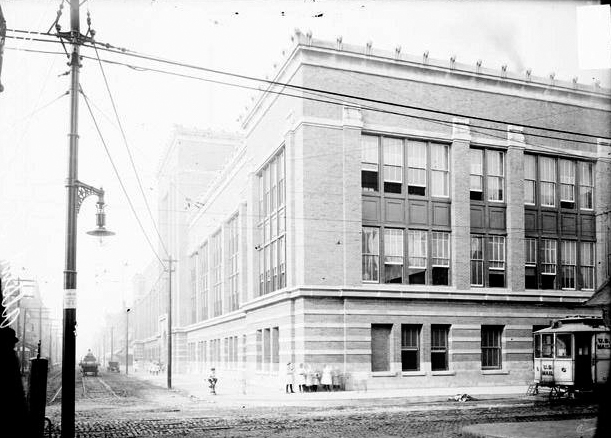
Albert G. Lane Manual Training High School, Chicago, Illinois. (1908)

Located on Division and Sedgwick, the Albert Grannis Lane Manual Training High School opened in September 1908. The school was formally dedicated on Washington's birthday, February 1909 and is named for Albert Grannis Lane, Chicago Superintendent of Schools. As industrial education's popularity continued to grow through the years and Lane added many new courses to its curriculum, Principal Bogan recommended that the school's name be changed to reflect all of the courses offered. In 1909 the school became known as the Albert Grannis Lane Technical High School.
Exterior view of the Albert G. Lane School with a group of children standing on the sidewalk at one corner of the building. The school was located at the intersection of West Division and North Sedgwick Streets in the Near North Side community area of Chicago, Illinois. (1908)
By 1915 the school was in full swing. The building was in almost constant use. Carpentry, cabinet making, and wood turning were offered to first year students. Sophomores were given extensive training in the fields of foundry, forge, welding, core making, and molding. Juniors worked in the most popular shop, the machine shop. It was equipped with 80 machines and 60 lathes cast and built at Lane. Seniors were given the most advanced shop, the electric shop. There they built motors, generators, transformers, and other instruments. Other classes, such as art, classical architecture, drafting, and English were offered to develop students' communication skills. The print shop was the best equipped high school print shop in America. It was equipped with the newest and most advanced equipment of the time. Its jobs included the 4 page Lane Daily, the 56 page monthly Tech Prep, and the annual 200 page yearbook plus other out of school jobs. At this time, Jack T. Nelson, a student, felt it was time for Lane to have a school song. He wrote the words and music of "Go Lane Go," making Lane one of only a handful of schools with an original school song.

In 1929 a comprehensive music program was established at Lane. Chicago Symphony Orchestra director Frederick Stock and Superintendent William Bogan worked together in making up the new curriculum. By 1930 Lane had grown to a population of 7,000 students. To relieve the overcrowded conditions at the school, it was decided to build a new Lane Tech. Board of Education architect John C. Christensen began preparing plans for the world's foremost high school complex. On June 24, 1930 groundbreaking ceremonies took place at Western and Addison. (today's Lane Technical High School) The new building was a beautiful combination of function and art. Like the old Lane, it was designed to allow the teachers and pupils to work in a comfortable environment. On dedication day, September 17, 1934, 9000 boys marched from Cubs Park to the new school. Lane's new population required many new provisions. Classes had to be staged in three shifts, and commencement exercises were held at the International Amphitheater.

World War II provided Laneites with many opportunities to show the ideals of Albert G. Lane and his school. Many war drives were carried out by Lane students. These drives provided the war effort with four Red Cross ambulances, a B-17 Flying Fortress, and over 3 million dollars in war bonds. Lane's 50th anniversary in 1958 brought a very important change to the school. America, fearing the Soviet space supremacy, became preoccupied with establishing a sound space program. To aid in the education of scientists and engineers, Lane assumed a closed admission policy. The school dropped its remedial courses and took only the students that would make the greatest contributions to American science.

The year 1971 brought the most noticeable change in Lane's history. The Board of Education approved Superintendent James Redmond's recommendation to admit girls to Lane Tech. He cited a drop in enrollment and the lack of a technical school that admits girls as reasons for the change. The school was in a turmoil after this decision. Fifteen hundred Lane boys protested at the Board of Education. The general fear was that the school's quality would drop and within a few years Lane would be just another high school. Actually, the school's overall academic quality improved with the addition of girls.

ALBERT GRANNIS LANE
Born in a small, modest home in 1841 on what is now the corner of State and Van Buren Streets, Albert Grannis Lane made a permanent impression on Chicago and its people. Imbued with a strong work ethic, Mr. Lane took his first job at the age of seven.

Through his initiative and hard work, Albert G. Lane earned an appointment as the principal of the Franklin School just after his graduation from high school. Thus, at the age of seventeen, he became the youngest principal in the history of the Chicago Public Schools system. In 1869, Mr. Lane became Superintendent of the Cook County schools where he made many innovations to improve the quality of the public schools. During his long career, Mr. Lane also served as Superintendent of the Chicago Public Schools and President of the National Education Association.

Mr. Lane's most cherished dream was the creation of a large high school dedicated to providing students with hands-on experiences in technical education while developing and enhancing their academic skills. Lane Technical High School is the realization of that dream.

Today they go by; Lane Tech College Prep High School.

Compiled by Dr. Neil Gale, Ph.D. 

Wednesday, October 31, 2018

Cream City (Amusement) Park, Lyons, Illinois. (1905-1908)

Cream City Park at 7601 W. Ogden Ave, Lyons, Illinois was built in 1905, only 15 miles from Downtown Chicago, on property that was previously the Fred Schultz quarry. The 45 acre site along the Des Plaines River was financed and controlled by wealthy Bohemian businessmen and a group of investors as a competitor to Chicago's White City Amusement Park. Joseph F. Klapka was chosen as the park’s general manager and promoter.
Cream City Amusement Park Entrance.
The park’s name was derived from the fact that all its buildings and towers were painted with a crème tint. Its main feature covering 15 acres was a reproduction of “Old Bohemia” (Czechoslovakia), featuring a Bohemian village with its picturesque streets, shops, modes of transportation, churches, theaters, natives, dancers, acrobats, musicians and mountain backdrop. Its large music hall seated 4,500 people and its dance pavilion held up to 1000 people, where live bands performed on weekends.
Bird's Eye View of Cream City Park.
Its entrance had five Grecian towers nearly 100 feet high flanked by eight massive arches in the center. Beyond was a natural lagoon, beautifully illuminated at night. At the far end along the Des Plaines River were facilities for bathing and boating.

There is little known about the rides and game attractions, but an advertisement in "Amusement Business Billboard Publications: gives some hint. It wasn’t unusual for parks to seek independent concessionaires because only large well financed parks owned all their own rides and concessions. Cream City sported an Old Mill, Merry-Go-round, Roller Coaster, Circular swing, Cave of the Winds, Billiard and Pool Hall, Illusion Shows, Pony Track, Skating Rink, a Ferris Wheel, An Electric Theater, Penny Arcade, Gypsy Camp, Katzenjammer Castle, Photo Gallery, Shooting Gallery and Japanese Tea Garden. 
Cream City survived only a few years, thanks in part to intense competition from White City Amusement Park, and it is believed, the beginnings of sewer work on Ogden Avenue that made reaching the park difficult.

Compiled by Neil Gale, Ph.D.

Saturday, October 27, 2018

The History of the Meskwaki (Fox) Indian Tribe and Fort du Renards (Fort Fox) built in 1730.


In historical writing and analysis, PRESENTISM introduces present-day ideas and perspectives into depictions or interpretations of the past. Presentism is a form of cultural bias that creates a distorted understanding of the subject matter. Reading modern notions of morality into the past is committing the error of presentism. Historical accounts are written by people and can be slanted, so I try my hardest to present fact-based and well-researched articles.

Facts don't require one's approval or acceptance.

I present [PG-13] articles without regard to race, color, political party, or religious beliefs, including Atheism, national origin, citizenship status, gender, LGBTQ+ status, disability, military status, or educational level. What I present are facts — NOT Alternative Facts — about the subject. You won't find articles or readers' comments that spread rumors, lies, hateful statements, and people instigating arguments or fights.

FOR HISTORICAL CLARITY
When I write about the INDIGENOUS PEOPLE, I follow this historical terminology:
  • The use of old commonly used terms, disrespectful today, i.e., REDMAN or REDMEN, SAVAGES, and HALF-BREED are explained in this article.
Writing about AFRICAN-AMERICAN history, I follow these race terms:
  • "NEGRO" was the term used until the mid-1960s.
  • "BLACK" started being used in the mid-1960s.
  • "AFRICAN-AMERICAN" [Afro-American] began usage in the late 1980s.

— PLEASE PRACTICE HISTORICISM 
THE INTERPRETATION OF THE PAST IN ITS OWN CONTEXT.


This Indian society is known to itself as the Meskwaki (sometimes spelled Mesquakie) or "People of the Red Earth." While there are variant spellings of the name." Neighboring Indian tribes referred to them as the “Outagami.” The French more commonly employed the name “Renard,” which in English becomes Fox.
The Meskwaki (Fox) Indian Tribe.
The Meskwaki originally lived in the lower peninsula of Michigan, but in 1656, when the first direct French contact with the Meskwaki is recorded by Father Gabriel Druillettes, they were occupying villages along the Fox and Wolf Rivers, near Lake Winnebago, in east-central Wisconsin.

Father Druillettes reports, "The two Frenchmen who have made the journey to those regions say that these people are of a very gentle disposition." At the time of contact, there may have been 1000 warriors with a total population of perhaps 2500. The French trader and adventurer Perrot were perhaps the only Frenchman to successfully interact with the Meskwaki. The exploitive and unscrupulous actions and sense of superiority of the French permanently disaffected them from French culture.

Meskwaki hunting parties ranged into northern Illinois, however, and in 1669 Jesuit priests reported that Meskwaki hunters encamped along the Des Plaines River in western Cook County had been mistaken for a Potawatomi tribe and had been attacked by a war party of Iroquois. Although they continued to reside in Wisconsin, by 1700, Meskwaki hunters frequently descended the Fox River Valley to hunt bison on the prairies of northern Illinois. Large numbers of Meskwaki also passed through the Chicagou region in 1710 when part of the tribe temporarily moved to the Detroit region.

In the first half of the eighteenth century, the Meskwaki became embroiled in at least three major periods of conflict with the French. From the French perspective, the Mesuqakies consistently blocked French economic interests and spread dissension and conflict among the Indians of the region.

A military confrontation between the Meskwaki and French at Detroit in 1712 ushered in a quarter-century of Meskwaki-French warfare. Although the Meskwaki returned to Wisconsin in 1712, Meskwaki Warriors continued to scour the Chicago region, attacking French traders, woodsmen, and French-allied Indians. After the defeat of the Meskwaki at Detroit, they preyed upon the French and their Indian allies throughout the upper Illinois country for four years.

On December 1, 1715, a Meskwaki war party led by Pemoussa (He Who Walks) attacked a French expedition led by Constant Le Marchand de Lignery and, in a series of skirmishes along the lakefront, drove the French and their allies back toward Michigan. The Meskwaki and French warfare flared intermittently for over a decade. Meskwaki war parties so disrupted the French fur trade in northern Illinois and Wisconsin that the French sent several additional expeditions against the Meskwaki villages.

During the period from 1719 to 1726, the Meskwaki were again at war with the Illinois and, by virtue of this, the French. Their raids extended as far as Fort de Chartres in southern Illinois. In 1726, in spite of a confused response on the part of the French, a formal peace was concluded.

By 1727 the French were again expanding trade with the Sioux and other societies of the upper Mississippi basin. French success in this venture depended on water routes cutting through central Wisconsin, hence the heart of the Meskwaki homeland. The Meskwaki resisted this incursion. The French response during this final period of conflict was attempted genocide. This policy culminated with the Meskwaki defeat on the prairies of east-central Illinois after a twenty-three-day siege.

The French campaigns achieved some success. During the summer of 1730, some of the Meskwaki attempted to abandon their villages in Wisconsin and pass through northern Illinois en route to joining the Senecas in New York. These Meskwaki descended the Fox River Valley just west of Chicago, crossed the Illinois River near Starved Rock, and traveled southeastward across the prairies in early August.

Over the course of several days, the Meskwaki built a defensive fort in the middle of a small grove of trees along the bank of the Sangamon River, surrounded by nearly two miles of open prairie. The fort was about 150 feet wide and 350 feet long. There were three walls with the Sangamon Riverside left open. They believed they had ample supplies of food and gunpowder and that the native tribes would not want to engage them in a long siege.

The French and their allies came upon the Meskwaki by the vicinity of today’s Village of Arrowsmith, formerly known as "Smith's Grove," in McLean County and not near Starved Rock, as many historical accounts claim. The Meskwaki took refuge in their new Fort, and after a 23-day siege, they broke through the French lines but were attacked and defeated by their enemies. They lost two hundred warriors and about three hundred women and children. This was the only battle ever fought in McLean County, Illinois.
Map of Meskwaki Conflict.
McTaggart (1973) relates to part of the Meskwaki oral tradition by recalling this event. It provides some sense of the Meskwaki people and is recounted here in this spirit:
It was back about the same time that White Robe lived; it happened in 1732 in Illinois when the Meskwaki were surrounded in the forest. We were surrounded on all sides by other Indian tribes and by the French and we couldn't get away.
There were two leaders. And they took the sacred bundle and started leading a song, a sacred song. And they drummed and they sang and they chanted until the other side all fell asleep. 
We had two runners, what you might call messengers. We don't have them any longer. And these two runners took a sacred wolf skin down to the river. And they were supposed to drag it lightly across the river to produce a fog.
But I guess they got overanxious in their duty and they dipped it in the water, dipped it in so that it was all covered up with water. On the top of it: they dunked it in the water. I guess they wanted to be sure that it would work. But instead it produced too much fog - a lot of rain and a lot of moisture in the air.
So while these people were all sleeping, the Meskwaki were to crawl away through this fog. As we were crawling over these sleeping bodies, we were being led by these two men who had taught us how to get away. One man's name was Mamasa: he was the drummer who had helped put the enemy to sleep. And the other man's name, I can't remember. 
But as our people were crawling over the sleeping bodies, the fog was so thick that we couldn't see each other. So in the middle of the line, somebody lost a hand hold and we couldn't see each other, so one group went in one direction and the other group went in the other direction. And the other group got lost from us.
While this narrative does little to pinpoint the location of Meskwaki Fort, it is intriguing in its own right. During this period, the Meskwaki were surrounded and heavily outnumbered by the French four times. On three of these occasions, they were able to employ the weather (a fog, a rainstorm, and a snowstorm) to escape and survive. Moreover, all of the French accounts of the siege remark on the singular nature of the storm that struck on the night of September 8, 1730. De Villiers states that it suddenly began an hour before sunset and lasted into the night "...so that, in spite of all I could say to our savages, I was unable to make them guard all the outlets." Reaume's narrative adds that the Meskwaki "...made a large fire... " inside their fort that night and thus forewarned him of their escape plans.

Following additional attacks upon their remaining villages in Wisconsin, in 1732, the Fox refugees established a new, heavily fortified village on Pistakee Lake, northwest of Chicago, astride the modern boundary between Lake and McHenry Counties. In October 1732, led by the war chief Kiala, the Meskwaki successfully defended this village against a large war party of French-allied Indians. However, during the following spring, they abandoned the village and returned to Wisconsin, where they sought sanctuary among the Sacs at Green Bay.

By 1733 fewer than 100 Meskwaki remained alive.

After 1733 the Meskwaki and Sacs lived together, first in Wisconsin, then in the lower Rock River Valley of northwestern Illinois, and finally in Iowa. A small village of Meskwaki reoccupied the Chicago region in 1741, but one year later, they rejoined their kinsmen near Rock Island.

Today, tribespeople from the Meskwaki Settlement near Tama, Iowa, form part of the modern Indian community clustered in Chicago's Uptown neighborhood.

French Accounts
While several documents that make reference to the siege are available in the published literature, only two may be properly considered primary accounts. One is the official report filed by Lieutenant Nicolas-Antoine Coulon de Villiers, Commandant at the River St. Joseph and commander of the French forces. The other is an unattributed narrative authored by a Fort de Chartres source under the direction of Lieutenant Robert Groston de St. Ange. De Villiers' account is dated September 23, 1730. It was carried to Quebec by his son, Louis Coulon de Villiers, and the interpreter, Jean-Baptiste Reaume. They delivered it to Charles de La Boische de Beauharnois, Governor of New France. The Fort de Chartres version is dated September 9, 1730, and was issued in New Orleans.

In the spring of 1989, a third narrative of the battle was identified in the Archives Nationales in Paris, France. The existence of the document had been suggested in a letter to the Minister of Marine from Giles Hocquart, Intendant of New France. It is dated November 14, 1730. In the missive, Hocquart indicates an "annexed relation" of the siege based upon his interview with Jean-Baptiste Reaume, de Villiers' interpreter. Hocquart even allows that he had "...retained the expressions of the Sieur Reaume which are according to Canadian usage." Hocquart's suggestion that it "...contains some details omitted by Monsieur Devilliers" is accurate from both history and archaeology perspectives.

The document is dated November  7, 1730, and was issued from Quebec. It thus precedes Hocquart's letter by a week. From the first paragraph, it is apparent that the informant and central character in the narrative is Jean-Baptiste Reaume, "...interpreter for the savages that dwell along the River St. Joseph." The account was transcribed by D'Auteuil de Monceaux. The document had been filed under a misspelling of his name. In a 1722 letter from Vaudreuil, Governor of New France, Auteuil is accused of being an immoral consort to the marriage of Jean-Baptiste Reaume's brother, Simon. Both Jean-Baptiste and Simon play major roles in the account.

The three accounts agree in general chronology and offer useful detail on the natural setting of the site and the architecture of the fort, and the strategy and internal politics of the allied forces. In July, the Meskwaki had captured several Cahokias near Fort St. Louis Le Rocher (Starved Rock) on the Illinois River and had burned the son of one of their chiefs. Angered, the Cahokias sent runners to Fort de Chartres seeking support. The Potawatomi, Kickapoos, Mascoutens, and The Illinois had also been attacked by the Meskwaki.

The Illinois had pursued the Meskwaki and found them marching east toward the Ouiatanons (west-central Indiana). Upon contact, The Illinois engaged the Meskwaki, who took possession of a small grove of trees and therein fortified themselves. (The Reaume narrative is the only one to provide a distance and direction reference to the fort. The interpreter places the site 50 leagues [1 League = 3.45 Miles] southeast of Fort St. Louis Le Rocher.) The next day runners were sent to the Miami post and to the St. Joseph command to report the fort's location and direct their support. The Fort de Chartres account indicates that the allied Indian forces had been awaiting aid for a month prior to the arrival of the French.

By August 10th St. Ange was moving north with 500 men and de Villiers southwest with 300. They joined with the 200 already present at the site. Another group of 400 Ouiatanons and Peanguichias under the command of Simon Reaume (Reaume Narrative) arrived the same day as de Villiers, bringing the total to about 1400 men at arms. St. Ange was the first to arrive (August 17th), with the rest of the forces arriving shortly after on August 20th.

According to the Fort de Chartres narrative, the Meskwaki fort was in:
...a small grove of trees surrounded by a palisade situated on a gentle slope rising on the west and north west side on the bank of a small river, in such manner that on the east and south east sides they were exposed to our fire. Their cabins were very small and excavated in the earth like the burrows of the foxes from which they take their name. 
For his part, de Villiers offers the following description of the enemy's position:
The Renards' fort was in a small grove of trees, on the bank of a little river running through a vast prairie, more than four leagues in circumference, without a tree, except two groves about 60 arpents {an old French unit of land area equivalent to about 1 acre} from one another.
He also adds that the Meskwaki had ditches on the outside of their fort.

The Reaume account adds little to the description of the natural environment, suggesting only the woods located in a "...prairie as far as the eye could see." However, it provides some interesting detail on the fortification:
The Renards fortified themselves in their woods and the allies in the prairie a half a league from each other. The Renard fort was of stakes a foot apart, crossed at the top, all joined together and filled in with earth between them as high up as the crossing. On the outside a ditch ran around three sides with branches planted to hide it, with pathways of communication for the fort in the ditches and others that ran to the river. Their cabins were complete with joists covered with decking, commonly called straw mats (natter de paille). On top of this there was two to three feet of earth, depending on the cabin. They were covered in ways such that one could see only an earthwork (terrasse) that would cast a shadow in the fort.
The main encampment of St. Ange was to the south of the river. This group positioned three redoubts and attendant trenches so as to command the river and deny the Meskwaki access to water. De Villiers' primary encampment was to the northeast or north of the Meskwaki fort. His forces constructed two cavaliers on the high ground overlooking the fort and an attack trench from which he hoped to set fire to the fort.

During the ensuing siege, the Allied forces were plagued with internal intrigues, shifting sympathies, and intertribal conflicts. The French alliance was a fragile one. On September 1st, Nicolas des Noyelles arrived with 100 men from the Miami Post. On September 7th, 200 of The Illinois deserted.

On the eighth of September, a terrible storm blew up, and as the Fort de Chartres narrative records, "...interrupted our work." The night was rainy, foggy, and very cold. The allied Nations refused to man their posts. Seizing this opportunity, the Meskwaki escaped from their fort. However, the crying of the children alerted the French sentries, and their flight was discovered. Fearful that their own allies would fire upon them in a night engagement, the French command determined to wait until daybreak before launching their assault. At dawn, some eight leagues from the fort (Reaume narrative), they rushed the exposed Meskwaki. Their ranks were immediately broken and defeated. The Reaume account further states that 500 were killed and 300 captured, and forty of the captured warriors were "burned." The Fort de Chartres narrative adds that not more than 50 or 60 unarmed men escaped.

Maps and Sketches
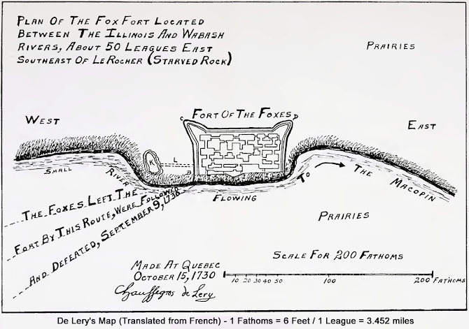
At least six maps of the siege are known to survive, as well as a planned view of the fort with a number of appended details. The official map of the battle camp (there are two drafts) and the plan of the fort with the appended details are signed by Chaussegros de Lery (respectively titled Blocus du Fort and Plan du Fort des Sauvages). De Lery was the chief military engineer of New France and was responsible for the official documents. De Lery's informants were de Villiers' son, Coulon, and the interpreter, Jean-Baptiste Reaume. These interviews occurred in Quebec when the two reported de Villiers' victory. The documents are variously dated November 10, 11, and 15 of 1730.
Bastioned plan close-up
Digrams of house, parapet, and fosse construction.
The Fort de Chartres narrative is associated with two maps (one a copy of the other) produced in New Orleans. They are titled Carte du Fort and are dated March 26, 1731. The legend indicates that it was based on the officers' reports. Nothing else is known about the production of this document, although it may have been generated by a royal engineer of Louisiana. At the time, engineers doing this type of work included Pierre Baron, Ignace Francois Broutin, and Francois Saucier.

Peyser (1987) has offered an extensive analysis of the two remaining charts. In light of the Reaume account, Fort des Renards and Sauvages Renards Attaques seem circumstantially associated with it. The references in the narrative correspond to those of the maps, placing as they do a singular emphasis on the roles of the Reaume brothers. It should be noted, however, that while the Hocquart communication references an appended narrative, it does not mention a map. Neither is signed or dated. Consequently, how these maps found their way to the records of the Minister of Marine remains open.

The present author has previously discussed the enigmatic variation between these several drawings regarding the basic geometry of the fort (Stelle 1989). In further addressing this difficulty, some new perceptions and possibilities have emerged. The Fort des Renards and the Sauvages Renards Attaques (Map 1 and Map 2, respectively) appear related not only in historical perspective but also with regard to artistic representation.
CLICK MAP 1 FOR A FULL-SIZE VIEW. 
Fort Des Renards. Note the generally primitive quality of the drawing and the absence of a north arrow and scale. The present author argues that it was the model upon which Sauvage Renards Attaques was constructed.
CLICK MAP 2 FOR A FULL-SIZE VIEW.
Sauvages Renards Attaques. Undated and unsigned, it is attributed to the Reaume Narrative by the present author.
Peyser (1987) views the Fort des Renards as a simpler, less complex document. Expanding on that observation, it could be that it is the original drawing, and Sauvages Renards Attaques is an edited, more detailed, and more stylized rendering. In the absence of historical information to the contrary, one might speculate that the original may even have been produced at the site. In any event, it is clearly a model for the Sauvages Renards Attaques. One must first properly orient the Fort des Renards document to observe these similarities by turning it upside down (north is not indicated). Secondly, the Sauvages Renards Attaques must be enlarged by 122% (no scale is indicated on either drawing). By then superimposing the two documents, one discovers that (1) the positions of the St. Ange battlements are plotted in the same exact positions relative to the river, (2) the encampments of de Villiers, des Noyelles, and Simon Reaume are in the same exact locations, (3) the encampment of St. Ange has been shifted up approximately 1/2 inch to accommodate the space reserved for the key, and (4) the renderings of the fort proper display a fundamental coincidence, one neatly tucked within the other. Additionally, while the author(s) of the documents remain unidentified, there is an unmistakable similarity in the key's drawing style, layout, and technique.

In spite of the intriguing linkages suggested in the foregoing discussion, which representation of the fort is correct remains unknown. The methods of historiography fail to provide an answer to this critical issue. The real promise of archaeology for history is that answers to questions of historical speculation are potentially available in the ground and can be determined upon the application of proper archaeological techniques. In this case, the validity of the drawings has the potential for empirical determination.

Proposed Locations
The same consideration applies to the actual location of the fort. As previously indicated, the poverty of colonial cartography and the absence of useful landmarks on the prairie have left the answer to this question problematic. At least ten tracts are offered in the literature as the site of the fort. Authors have chosen their locations on the basis of their perceptions of the veracity of the historical documents and their interpretation of distance and direction measurements. All distance and direction references are generalized and presumably reflect surface rather than statute distances. This ambiguity has left much room for historical speculation.

Only the newly surfaced Reaume Narrative provides a distance and direction reference of the three narratives. The other two are surprisingly silent with regard to this central fact. Reaume indicates that the Meskwaki were found "...50 leagues (173 miles) southeast of Fort St. Louis Le Rocher."
CLICK MAP FOR FULL-SIZE VIEW
The three statements that researchers have relied upon are:

(1) the legend of de Lery's Blocus du Fort and Plan du Fort des Sauvages. 

(2) a letter from Hocquart to the French Minister of Marine, dated January 15, 1731. 

(3) a detail in the map Sauvages Renards Attaques. De Lery indicates that the fort was located 50 leagues east southeast of Fort St. Louis Le Rocher.

Hocquart's report states "...in a plain situated between the Wabache and the Illinois rivers, about 60 leagues to the south of the extremity or foot of Lake Michigan, to the east-south-east of Fort St. Louis Le Rocher in the Illinois Country."

Lastly, the detail on the Sauvages Renards Attaques chart indicates that the fort was located on the River of the Renards or the Beiseipe River, which flowed into the Mabichi River. The Mabuchi, in turn, emptied into the greater Wabash River. The detail further adds that this river system extended to within 40 leagues of Fort St. Louis Le Rocher and was located to the southeast.

What seems consistent about these descriptions is a location southeast or east southeast of Fort St. Louis Le Rocher some 40 to 50 leagues in a then unmapped region of Illinois. With river systems uncharted at the time and river names unrecognizable today, these referents are of little direct use.

An article on May 18, 1897, in Pantagraph Newspaper confirms that a fort's outlines (breastwork) still existed. October 9, 1901, Daily Bulletin reports a few miles west of Cheney's Grove and southeast of the Village of Arrowsmith on a small tract of land, not over ten acres, evidence was found of an early battlefield.
Brass metal fragments were found on the battlefield.
Fort du Renards Battle Site after Two Hundred Years.
A group of historians visited the scene of the old battlefield near Fort du Renard's breastwork and made a number of excavations. Musket pits were found containing scraps of human bones, ashes, the barrel of a small pistol, bullets and other evidence of the struggle.
An engraved boulder was unveiled Sunday on the Roy Smith farm near the Village of Arrowsmith, Illinois, marking Etnataek, the site of a bloody Indian-French battle in 1730. Etnataek is Algonquin for “where fight, battle or clubbing took place.” After the extensive historical study, William Brigham of Bloomington (above), Historian and former superintendent of schools, established the battle site in the Arrowsmith area. Modern historians and archaeologists no longer use the French term Etnataek to describe the site. 1951
This peaceful landscape in eastern McLean County was the scene of a bloody 1730 siege of Fox Indians by the French and their Indian allies. Photo shot in 2007.
Compiled by Dr. Neil Gale, Ph.D.