
Initially, the Illinois Country was under the jurisdiction of the Canadian province of Quebec, but in 1717, it was transferred as a district to the province of Louisiana. The first commandant of the Illinois Territory was Pierre Duque Boisbriant, who arrived in December of 1718 with orders to govern the country and erect in the Mississippi Valley a bastion to forestall possible aggressions of the English and Spanish as well as to protect the settlers from hostile Indians. With eagerness, he started to build the most pretentious in the chain of forts along the Mississippi River.
sidebar
The word "Mississippi" comes from the Ojibwe Indian Tribe (Algonquian language family) word "Messipi" or "misi-ziibi," which means "Great River" or "Gathering of Waters." French explorers, hearing the Ojibwe word for the river, recorded it in their own language with a similar pronunciation. The Potawatomi (Algonquian language family) pronounced "Mississippi" as the French said it, "Sinnissippi," which was given the meaning "Rocky Waters."
The First Fort
Fort Chartres was the creation of the Company of the West, or Mississippi Company, which was organized by the celebrated John Law in August 1717, immediately after the surrender by the Sieur Antoine Crozat (Crozat, marquis du Châtel, the French founder of an immense fortune, was the first proprietary owner of French Louisiana, from 1712 to 1717.) of his patent and privileges in Louisiana to the French crown. It was named Fort de Chartres, presumably in complement to the Regent of France, from his son's title, the Due de Chartres. This commercial company and its early successor, the Royal India Company, held away in the province of Louisiana, of which Illinois formed a part for fourteen years.
On February 9, 1718, three ships of the Western Company – the Dauphin, Virilante, and Neptune – arrived at Dauphin Island with officers and men to take possession of Louisiana. On one of these vessels, or on the frigate La Duchesse de Noailles, which arrived at Ship Island on March 6, came Pierre Duque de Boisbriant, a French Canadian, who had been commissioned first king's lieutenant for the province of Louisiana, and who was the bearer of a commission appointing his cousin, LeMoyne de Bienville, governor and commandant general of the region, in place of M. L'Epignoy's removal.
In the early part of October 1718, Lieutenant Boiabriant, with several officers and a considerable detachment of troops, departed by bateau (boats) from Biloxi, through lakes Pontchartrain and Maureeas and up the Mississippi to regulate affairs in the Illinois County and to establish a permanent military post for the better protection of the French inhabitants in their northern district of the province. Arriving at Kaskaskia late in December of that year, he established his temporary headquarters, which was the first military occupation of the village. This, however, was continued for only about 18 months.
Having selected a convenient site for his post, some 18 miles northwest of Kaskaskia, de Boisbriant brought a large force of mechanics and laborers to work in the forest.
This palisaded log fortification, completed in the spring of 1720, covered 1¾ square miles and was located on the Mississippi River about sixteen miles northwest of Kaskaskia. It served as the company's headquarters and the civil, military, and marine government authority of the Illinois Territory (1809-1818). Its erection was meant to pursue three economic goals set by the company: to facilitate the fur trade, to kick-start lead mining, and to develop regional agriculture.
The company decided to build the new fort between two villages, should they ever need to quickly intervene in either place: Cahokia to the north, Kaskaskia to the south. Its construction, led by Captain Pierre Dugué, sieur de Boisbriant and first lieutenant of the king, was pretty rudimentary. Its shape was rectangular with two diagonally opposed bastions. Its wooden palisade, measuring about 190 feet on each side, was surrounded by a dry moat. This fort contained only three buildings, lodging about one hundred men.
The fort stood on the alluvial bottom (sand, silt, clay, gravel, or other matter deposited by flowing water, as in a riverbed, floodplain, or delta. Alluvium is generally considered a young deposit in terms of geologic time.) about 3/4 of a mile from the Mississippi River and near to an older fort that had been erected by the adventures under Crozat. Midway between it and the bluffs on the east extend a bayou of the lake, which was supposed to add to the strategic strength of the place.
The fort was built of wood and was very large, but whether it was furnished with bastions is still being determined. It is described as a stockade fort, fortified with earth between the rows of palisades. Within the enclosure were erected the commandant's house, the barracks, the large storehouse for the company, etc., the same being constructed of hewed timbers and ship-sawed planks.
Although not a strong fortification, except against Indian attacks, it was made to answer the needs of its builders and commandants who successfully ruled here for an entire generation. Moreover, it formed an essential link in the lengthened chain of French posts stretching from eastern Canada to the Gulf of Mexico. The idea of this long line of military and trading posts appears to have originated in the fertile brain of that explorer, René-Robert Cavelier, Sieur de La Salle. Poor maintenance and frequent flooding caused this fort to be abandoned.
Two chapels, one in Prairie du Rocher and the other in St. Philippe, were managed by the parish of Saint Anne, which, in turn, was alternately run by the Society of Foreign Missions, Jesuit, and Recollect missionaries. Unfortunately, the fort, constructed at a "musket's shot" distance from the Mississippi River, was regularly flooded by rising waters in the spring. Consequently, the first fort was only used for a few years before being replaced.
Village of Nouvelle Chartres (1720-1765)
Shortly after the completion of the fort, the Louisiana government founded a village outside of the fort that shared the same name, Nouvelle Chartres, in 1720. Contrary to New France's Fortress of Louisbourg (in Canada) or Fort Michilimackinac in today's State of Michigan, the inhabitants did not live within Fort de Chartres. Settlers from Canada and France, confident of protection, arrived and clustered near the fort. They wondered whether the native Indians could be trusted. While the local Metchagamia tribe near the fort proved to be anything but warlike, in 1729, the Natchez Indians, provoked by the tyranny and greed of the French commandant Chobart – incited a conspiracy against the French. Massacres were frequent.
In 1736, the garrison of Fort Chartres marched against the Chickasaw Indians, who threatened to cut communications between the Illinois Country and the city of New Orleans. The focal point of this little French community of Nouvelle Chartres was the parish church of St. Anne du Fort de Chartres. Commander Jean-Jacques Macarty's census tallied the population to 198 French, 89 black slaves, and 36 panis (native) slaves in 1752. Thus, the Village of Chartres people were classed third in importance after Cahokia and Kaskaskia. The fort itself could accommodate up to 300 soldiers.
The village of Chartres disappeared shortly after 1765, making way instead for the parish of Saint Joseph in Prairie du Rocher, which still exists today.
The Second Fort
The second fort was constructed sometime around 1725. Erected near the first fort, it was a little smaller than its predecessor but included four bastions. A small chapel and a hospital were constructed outside the palisade. Just like the first fort, it often flooded. After the West India Company failed to find gold and precious minerals, the government of New Orleans took control of the region and the fort. The decrepit state of the fort forced the garrison to move to Kaskaskia in 1747.
The Third Fort
The land exploitation never yielded precious metal deposits, but the region became an important lead source. The fertile ground is favorable to agriculture.
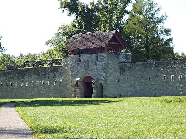 |
| Fort de Chartres' gate. Note that initially, the entrance faced the river, while that of the rebuilt fort faces away from it. |
 |
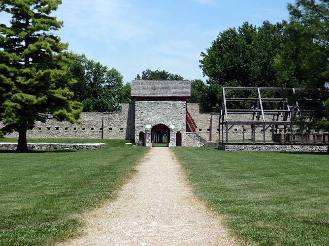
| The third fort, erected in 1753 |


The End of the Fort
Although it was constructed out of stone, the new fort was not made to resist grand artillery fire but to withstand native sieges. Luckily, despite the apprehensions of Commander Pierre-Joseph Neyon de Villiers, Fort de Chartres was never the target of any English offensive. In theory, should Canada be lost, the head staff of the French army expected to retreat to it with a few thousand soldiers to attack Virginia and Carolina. In the end, this plan was never put into action.

As for the residents of the East shore of the Mississippi, most moved onto the western shore, which was thought to be more hospitable because of the presence of a Spanish catholic government.
From Deterioration to Valorization
Once abandoned, Fort de Chartres was only occasionally occupied by errant natives. The fort quickly deteriorated, and vegetation reclaimed the land; thus, by 1804, about thirty years after being abandoned, the presence of trees measuring 7 to 12 inches in diameter was reported within the old enclosure. The repetitive scavenging of material from the fort by the inhabitants of neighboring communities contributed to the gradual disappearance of its last remains.
 |
| The ruins of Fort de Chartres / Fort Cavendish with powder magazine intact. |
The partial reconstruction of the fort, undertaken through a governmental construction program, spread over many years: the storehouse was rebuilt in 1929; the gate in 1936; the guardhouse in 1940; finally, the foundations of anything that wasn't reconstructed were covered with a layer of cement to stop erosion.
Systematic archaeological digs at Fort de Chartres were only undertaken in the 1970s and 1980s. These first digs were held following public pressure insisting that the fort be rebuilt in the most authentic way possible; thus, the North Wall was reconstructed during the 1980s on its original foundations. Essentially carried out on the site of the third fort, these digs were followed by a second archaeological search, which confirmed the location of the first Fort de Chartres.
The efforts invested in research and reconstruction guarantee Fort de Chartres' place in the heart of the Illinois Country's French heritage.
The fort site was recognized as a National Historic Landmark in 1966. The fort site was added to the National Register of Historic Places in 1974.
Currently managed by the Illinois Historic Preservation Society, the site is open to visitors with access to its museum and a library dedicated to the fort's history.
Fort de Chartres State Historic Site


Compiled by Dr. Neil Gale, Ph.D.
Photographs copyright © Dr. Neil Gale, Ph.D.
[1] Malaria was a common disease in Chicagoland and southern Illinois in pioneer days, wherever swamps, ponds, and wet bottomlands allowed mosquitoes to thrive; the illness was called ague, or bilious fever, when liver function became impaired; medical historians believe that the disease came from Europe with early explorers around 1500; early travel accounts and letters from the Midwest reports of the ague (a fever or shivering fit), such as those of Jerry Church and Roland Tinkham, the details of which are extracted from their writings:
From the Journal of Jerry Church, when he had "A Touch of the Ague" in 1830: ...and the next place we came to of any importance was the River Raisin, in Michigan. There, we met with several gentlemen from different parts of the world, speculators in land and town lots and cities, all made out on paper, and prices set at one and two hundred dollars per lot, right in the woods, and musquitoes and gallinippers thick enough to darken the sun. I recollect the first time I slept at the hotel. I told the landlord the next morning I could not stay in that room again unless he could furnish a boy to fight the flies, for I was tired out myself, and not only that, but I had lost at least half a pint of blood. The landlord said he would remove the mosquitoes with smoke the next night. He did so, and after that, I was not troubled so much with them. We stayed there a few days, but they held the property so high that we did not purchase any.
Fort de Chartres State Historic Site

 |
| Powder Magazine |


Compiled by Dr. Neil Gale, Ph.D.
Photographs copyright © Dr. Neil Gale, Ph.D.
[1] Malaria was a common disease in Chicagoland and southern Illinois in pioneer days, wherever swamps, ponds, and wet bottomlands allowed mosquitoes to thrive; the illness was called ague, or bilious fever, when liver function became impaired; medical historians believe that the disease came from Europe with early explorers around 1500; early travel accounts and letters from the Midwest reports of the ague (a fever or shivering fit), such as those of Jerry Church and Roland Tinkham, the details of which are extracted from their writings:
From the Journal of Jerry Church, when he had "A Touch of the Ague" in 1830: ...and the next place we came to of any importance was the River Raisin, in Michigan. There, we met with several gentlemen from different parts of the world, speculators in land and town lots and cities, all made out on paper, and prices set at one and two hundred dollars per lot, right in the woods, and musquitoes and gallinippers thick enough to darken the sun. I recollect the first time I slept at the hotel. I told the landlord the next morning I could not stay in that room again unless he could furnish a boy to fight the flies, for I was tired out myself, and not only that, but I had lost at least half a pint of blood. The landlord said he would remove the mosquitoes with smoke the next night. He did so, and after that, I was not troubled so much with them. We stayed there a few days, but they held the property so high that we did not purchase any.
The River Raisin is a small stream of water, similar to what the Yankees call a brook. I was very much disappointed in the appearance of the country when I arrived there, for I anticipated finding something great, and I did not know that I might find the article growing on trees on the River Raisin! But it was all a mistake, for it was rather a poor section of the country. ...We then passed on to Chicago, and there I left my fair lady traveler and her brother and steered my course for Ottawa in Lasalle, Illinois. When I arrived there, I put up at the widow Pembrook's, near the town, and intended to make her house my home for some time. I kept trading round in the neighborhood for some time and, at last, was taken with a violent chill and fever and had to make my bed at the widow's, send for a doctor, and commence taking medicine, but it all did not do me much good. I kept getting weaker every day, and after I had eaten up all the doctor stuff the old doctor had, pretty much, he told me that it was a very stubborn case, and he did not know if he could remove it and thought it best to have counsel. So I sent for another doctor, and they both attended me for some time. I still kept getting worse and became so delirious as not to know anything for fifteen hours. I, at last, came to and felt relieved. After that, I began to feel better and concluded that I would not take any more medicine of any kind, and I told my landlady what I had resolved. She said that I would surely die if I did not follow the directions of the doctor. I told her that I could not help it, that all they would have to do was to bury me, for my mind was made up.
In a few days, I began to gain strength, and in a short time, I got so that I could walkabout. I then concluded that the quicker I could get out of those "Diggins," the better it would be for me. So I told my landlady that I intended to take my horse and wagon and try to get to St. Louis, for I did not think I could live long in that country. I concluded I must go further south. I accordingly had my trunk re-packed and made a move. I did not travel far in a day but, at last, arrived at St. Louis, very feeble and weak, and did not care much how the world went at that time. However, I thought I had better try and live as long as possible.
From a letter by Roland Tinkham, a relative of Gurdon S. Hubbard, describing his observations of malaria during a trip to Chicago in the summer of 1831: ...the fact cannot be controverted that on the streams and wet places, the water and air are unwholesome, and the people are sickly. In the villages and thickly settled places, it is not so bad, but it is a fact that in the country where we traveled the last 200 miles, more than one-half the people are sick; I know, for I have seen it. We called at almost every house, as they are not very near together, but still, there is no doubt that this is an uncommonly sickly season. The sickness is not often fatal; ague and fever, chill and fever, as they term it, and in some cases, bilious fever are the prevailing diseases.
From a letter by Roland Tinkham, a relative of Gurdon S. Hubbard, describing his observations of malaria during a trip to Chicago in the summer of 1831: ...the fact cannot be controverted that on the streams and wet places, the water and air are unwholesome, and the people are sickly. In the villages and thickly settled places, it is not so bad, but it is a fact that in the country where we traveled the last 200 miles, more than one-half the people are sick; I know, for I have seen it. We called at almost every house, as they are not very near together, but still, there is no doubt that this is an uncommonly sickly season. The sickness is not often fatal; ague and fever, chill and fever, as they term it, and in some cases, bilious fever are the prevailing diseases.
I am trying to determine if all of the birth/death/marriage records for the fort are located at the Belleville Public libray?
ReplyDeleteHello,
DeleteI too am trying to access the fort records and was wondering if you had any luck?
Thanks,
Jeff Larsh
I did finally speak with the research area of Belleville Public Library and the records are generally there, though I haven't been able to go visit due to the pandemic.
DeleteWe are looking for physical measurements and dimensions of the fort and fort buildings for a model project for scouts. Are these available?
ReplyDeleteI have not found the measurments.
Delete