Thursday, January 11, 2018

Seymour Paisin Ladies Apparel on Devon and Talman Avenues in Chicago, Illinois.

1963
The Seymour Paisin Ladies Apparel (Seymour Paisin on Devon, Inc.) was located at 2629 West Devon and Talman Avenues in Chicago. Seymour Paisin (1912-1987) and his wife and co-founder Ruth (1914-1977) opened Seymour Paisin Ladies Apparel in 1950, and the shop closed in the early 1980s.

The Paisins began quarter-page advertising in the Chicago Tribune in September of 1951.

Only a little information is available about the store or Seymour. It was "THEE" place to shop for high fashion, second only to Chicago's Downtown.
1973
My mom shopped there a lot! We lived 2½ blocks away, and she would take me out for a walk when I was very young. I can remember sitting in one of their big chairs and looking out the windows, watching traffic go by and people walking on Devon Avenue while my mom tried on dress after dress.
Chicago Tribune, September 13, 1951
Dress Label
Ruth & Seymour Paisin


By Dr. Neil Gale, Ph.D. 

The Late Eighteenth Century Illinois Counterfeiter, John Duff.

In the early nineteenth century, money followed the waterways in Illinois. Trade routes developed along the state's rivers, connecting Illinois to the rest of the fledgling nation. Along the Ohio River, something else followed the waterways in southeastern Illinois - criminals. Preying on the burgeoning river trade, these shady characters took advantage of the seclusion of the frontier to ply their illegal trade.

One such scofflaw was named John Duff (or just Duff, John Michael McElduff, John McDuff, Jean Michel Duff, or one of several other assumed names). To many, though, he was known simply as Duff the Counterfeiter.

John Michael McElduff (commonly known as John Duff) was born sometime between September 1759 and August 1760 in South Carolina, according to his court testimony in August 1781, where he claimed to be 21 years old.

Duff served in the American Revolutionary War in the Illinois Campaign (1778-1779); the Capture of Kaskaskia and Cahokia (1778); the Siege of Fort Vincennes (1779); and the Battle of St. Louis (1780).
Private John Duff served in the ranks of George Rogers Clark's Illinois Regiment, walking through chest-high, icy water, on the march to Vincennes, January 1779, in a painting, by Frederick Coffay Yohn.
Around 1778, Duff was living in the Illinois Country, later referred to as the "American Bottom." While leading a group of long hunters (a Longhunter was an 18th-century explorer and hunter who made expeditions into the American frontier wilderness for an extended period of time) returning to Kaskaskia, Illinois, John Duff, John Saunders, and the rest of the hunting party was intercepted by Colonel George Rogers Clark's soldiers and his Virginia frontiersmen soldiers, near the ruins of Fort Massac (Metropolis, Illinois). Suspected of being British spies, they immediately took an American oath of allegiance, where Duff and his men joined Clark's Illinois Regiment, Virginia State Forces. Duff enlisted into Captain John Williams' Company in Cahokia and rose to the rank of sergeant in the Illinois Regiment.

In 1780, while Duff was posted with the garrison in Cahokia, the British attacked St. Louis, which was under colonial Spanish rule, and American-held Cahokia in 1780, with a motley army of French-Canadians, fur traders, and their Indian allies. McElduff and other soldiers were on reconnaissance for General Clark, observing the British movements near the Mississippi River. The group was attacked by an Indian war party, barely escaping with their lives. The combined American, French, and Spanish forces successfully repelled the enemy assaults. In the George Rogers Clark Papers and Illinois court records, Duff was referred to both as "John McElduff" and "John McDuff."

In the mid-late 1780s, Duff was living in Kaskaskia, Illinois, and was in business with two brothers of the captain of the Ohio County, Virginia Militia, and Revolutionary War Patriot, Samuel Mason, who later became the notorious river pirate. According to the French Kaskaskia records, the Duff name was recorded as "Jean Michel Duff" and "John Michael Duff." In 1786, John, Daniel, and another son of Thomas McElduff sold land tracts for two different property deeds. There was a Daniel McElduff and McDuff who was also at Kaskaskia in the 1780s and was likely the brother of John Duff.

When the McElduffs first arrived, the pre-American Revolution, a British-controlled, French-speaking settlement of Kaskaskia, was not recorded. Daniel McDuff owned slaves while residing in Kaskaskia, as was the custom of transplanted Southerners and the French Creole population in the Illinois Country. After the departure of the bandit John Dodge, who lived in the area from 1784-1790, John McElduff was elected, in 1790, as one of six judges, to the Kaskaskia town court. According to the French records, on February 6, 1794, John McElduff and Seddy, his wife, sold a dwelling and grounds in Kaskaskia Village to J.R. Jones for $200; this Jones may have been John Rice Jones, an Illinois Regiment veteran, noted politician, and the first lawyer in the Illinois Country.

After 1790, John Duff was associated with the South Carolina counterfeiter Philip Alston, the Virginia river pirate Samuel Mason, and the North Carolina mass murderers the Harpe Brothers at Cave-in-Rock, in the U.S. Northwest Territory, where he learned the illicit business of counterfeiting, known as "coining," where he could make a lot of money in criminal pursuits.
The Spanish silver peso (Silver Eight Royals Coin of Charles III of Spain, 1776) was the most common currency found on the American frontier. Counterfeiters John Duff and his associate, Philip Alston, were "coining" this type of money at Cave-In-Rock. The "Spanish milled dollar" was minted in México and considered legal tender, in the United States, until the Coinage Act of 1857.
Philip Alston was a South Carolinian of polished manners and good education who, early in his life, learned the art of counterfeiting, His specialty was not bogus notes so much as bogus coins.

It must have been from Alston that Duff learned "coining," and Alston probably furnished the tools and dies for this manufacture since Duff would hardly have the skill. Duff was spurred to this new activity by his discovery of a mine containing lead with a certain amount of silver in it, on the banks of the Saline River in Illinois, which flows into the Ohio River not far above the Cave-in-Rock.
Cave-in-Rock, Illinois.
A coining die, for the making of counterfeit half dollars, was found in the cave years later, which may have belonged to Alston and later to Duff.

By this time, he had left the historical record, and from this point on, he was referred to in folklore as just Duff or "Duff the Counterfeiter." Even as a counterfeiter, John Duff was not a violent man by nature, and he was never known to have killed anyone.

There is an account of Duff blindfolding a woman to show her his stash of counterfeit silver-clad lead coins in dozens of chests. 

Whether or not John McElduff and his wife left Kaskaskia permanently after 1794 is not known, but folklore mentioned John Duff as owning a slave named Pompey and tales of his miraculously avoiding numerous attempts at capture and death from local regulator vigilantes and the U.S. Army.

The story of his death? That's not so clear. There are at least three accounts of how Duff died. Here are two of the most probable:

1) According to Revolutionary Soldiers Buried in Illinois, Duff was murdered in 1805 while he was drunk at the Island Ripple near the Great Salt Springs in Gallatin County, Illinois. The mouth of the Tradewater is on the Kentucky side and is used to describe the site of Flynn's Ferry, an early crossing point. The road from Flynn's Ferry ran to the Great Salt Spring. Later it became known as Ford's Ferry Road. The road from Shawneetown to the Great Salt Springs intersected the first road on the west side, where it crosses the Saline River. That crossing point or ford is called Island Ripple, or "riffle," as the local dialect pronounces it. The Saline River empties out into the Ohio River just a few miles above the Tradewater. Duff was buried near the local salt springs.

2) Duff had become a scourge along the lower Ohio River region for nearly a decade. On June 4, 1799, a group of three Shawnee Indians and a French courier du bois guide were hired by U.S. Army Captain Zebulon Pike, Sr., (and the father of the namesake of Pike's Peak) father of the explorer, who was the commandant at the frontier outpost, of Fort Massac, which is now Metropolis, Illinois. This mercenary party was given orders to kill John Duff, which they did at his house, which was located either at Battery Rock, according to the newspaper account, on the Illinois side of the Ohio River or across the river at what would later, become Caseyville, Kentucky as, recalled in the History of Union County, Kentucky.

Shrouded in mystery, Duff's life and death reflect the seamier side of life on the frontier in Illinois. In years since, there have been many searches for "Duff's treasure" in caves and other places along the Saline River, but all have been fruitless, at least as far as any records show.
John Duff Signature
Compiled by Dr. Neil Gale, Ph.D. 

Wednesday, January 10, 2018

Illinois 'River Pirates' in the Northwest Territory in the 1790s.

The "Wild West" image that comes to mind is that of the Western United States in the decades after the Civil War. In the late eighteenth century, the Wild West was a bit further east, so to speak. In its pre-statehood days, Illinois had its share of ne'er-do-wells, confident men, thieves, and murderers.
Samuel Ross Mason

One such man was Samuel Ross Mason (also spelled Meason). Mason was born in Virginia in 1739 and served in the Pennsylvania Militia during the Revolutionary War. Mason stole provisions in Virginia, robbed houses in Knoxville, Tennessee, and killed a constable in Kentucky.

This final act led him to move his headquarters further downriver to Cave-in-Rock (now the Cave-in-Rock State Park in Hardin County) on the Illinois shore in 1797. By this time, he had gathered a number of followers who openly based themselves at Cave-in-Rock. 

The Ohio River in the 1790s was a teeming inland highway of commerce and emigrants.

Here, Mason and his men would warmly welcome riverboat travelers to rest and eat. However, while these visitors enjoyed the hospitality, Mason's men checked their supplies and goods for anything of value. If they found something, they would wait until the next day and, when the visitors continued, would rob them as they made their way around the river's bend.

Philip Alston was a South Carolinian of polished manners and good education who, early in his life, learned the art of counterfeiting, His specialty was not bogus notes so much as bogus coins. A coin die, for the making of counterfeit half dollars, was found in the cave, which may have belonged to Alston and later to John Duff.
Cave-in-Rock, Illinois.
Cave-in-Rock was the most famous of the counterfeiting caves and one of the first of the "coiners," John Duff, was the probable brother-in-law of Samuel Mason, seems to have operated in the Cave while Mason and his robbers were still there, and began those operations even before Mason moved in.
While at Cave-in-Rock, Mason and his men briefly harbored the notorious Wiley Harpe and his brothers, who were on the run from the law. The Harpe Brothers were the most brutal outlaws then and distinguished themselves as America's first serial killers. Though the Mason Gang could be ruthless, even they were appalled at the actions of the Harpes. After the murderous pair began to take travelers to the top of the bluff, stripping them naked and throwing them off, they were asked to leave.
Cave-in-Rock, Illinois, view on the Ohio River (circa 1832).
In the summer of 1799, the Mason Gang was forced to leave Cave-in-Rock when they were attacked by a group called the “Exterminators.” Captain Young of Mercer County, Kentucky, led this group of vigilante bounty hunters. Mason then moved his operations downriver, settled his family in Spanish Louisiana, and became a highwayman on the Natchez Trace in Mississippi, robbing and killing unsuspecting travelers. It was on the Natchez Trace that Mason received his most infamous nickname. He would leave a message after each crime (often in the blood of his murdered victims), proudly stating, "Done by Mason of the Woods."

In April 1802, Mississippi Governor William C.C. Claiborne was informed that Samuel Mason and Wiley Harpe had attempted to board the boat of Colonel Joshua Baker between Yazoo and Walnut Hills, now Vicksburg, Mississippi. The governor responded by ordering Colonel Daniel Burnet, with 15-20 volunteers to track down Mason and his men. A reward of $2,000 was offered for their capture.

Though there were dozens of men searching for the Mason Gang, the outlaws continued with their evil deeds along the Natchez Trace, striking one caravan with horrific brutality. In response, another posse of local residents and a few bounty hunters was raised to go after them. Learning that Mason and his men were hiding out less than a mile west of the Trace near Rocky Springs, Mississippi, the posse quickly pursued. When they came upon the camp, they found it had been hastily abandoned. Though the outlaws' trail was fresh, most of the posse chose not to follow, instead remaining at the camp searching for any hidden loot that the outlaws may have left. A few men, however, continued the pursuit, but when they lost the trail, they abandoned the search.

Months later, Spanish officials were more successful. In January 1803, they arrested Mason, four of his sons, and several other men at the Little Prairie settlement, now Caruthersville, in southeastern Missouri. Mason and his family members were taken to the colonial government in New Madrid, Missouri, where a three-day hearing was held to determine whether Mason was a pirate. Although Mason claimed he was simply a farmer who had been maligned by his enemies, the presence of $7,000 in currency and 20 human scalps in his baggage convinced the Spanish he was guilty. Mason, his family, and the other men were then boarded on a boat to be taken to New Orleans, where they would be handed over to the American governor in the Mississippi Territory. However, while being transported, Mason and Wiley Harpe, using John Sutton's alias, overpowered their guards and fled. Though Mason was shot in the leg, he made good his escape.

Governor William C. C. Claiborne immediately added an additional $500 reward for their recapture, making the total reward $2500. This staggering amount prompted Wiley Harpe and another man to bring Mason's head in an attempt to claim the reward in September 1803. Whether they killed Mason or he died from his leg wound is unknown. However, rather than collecting a reward, the two pirates were recognized, arrested, tried in federal court, and found guilty of piracy. They were hanged in Greenville, Mississippi, in early 1804.

Rivers hold many legends and stories. Mason's is one of the few stories of river pirates in Illinois that can be substantiated. It speaks to Illinois's days as a part of the wild frontier.

Compiled by Dr. Neil Gale, Ph.D. 

Abraham Lincoln's Nomination for President in Chicago in 1860.

Abraham Lincoln, June 3, 1860
Probably the most shocking political event to occur in Chicago in the middle 1800s was on May 18, 1860, when Abraham Lincoln was nominated for the Presidency of the United States in a two-story wooden hall called the Wigwam.

It was a carefully engineered event and one that rarely occurred. To this day, many are still pondering the mystery of how a minor contender in the presidential race managed to achieve a sweeping victory with the third nomination ballot.

The key to solving the mystery is Chicago itself. Lincoln's supporters, who had fashioned the man with the image of a backwoods rail-splitter, were thrilled that the event was held in the city. Lincoln was an Illinois man with many friends and newspaper support on the prairie.

The Republicans were holding only their second National Convention and, for the first time, had a chance to usher one of their candidates into power. The dominant Democratic Party was split over the issue of extending slavery into the territories, and their divided vote gave the Republicans hope. Coming into Chicago, the favorite to win the nomination was New York senator William H. Seward. His supporters and delegates were so assured of his victory that they focused more on his choice of a running mate than on his actual nomination.
The Old Chicago Wigwam Building. The building in which Lincoln was nominated for the Presidency on May 18, 1860.
The Convention opened on Wednesday, May 16, with over 10,000 people packed into the Wigwam while an additional 20,000 stood outside. Four years earlier, in Philadelphia, the Republicans had drawn no more than 4,000 people to their Convention. The meeting was called to order and was followed by a stirring address from David Wilmot of Pennsylvania. After that, the day was spent electing a chairman and constructing a platform. The platform was adopted.

Served at the Republican National Convention in Chicago were David Berg hot dogs, founded in Chicago in 1860. It was a trendy item because it was hand-held and easy to eat. Lincoln did not attend the Convention, staying in Springfield, so there was no chance of him eating a David Berg hot dog.

The platform was modified on Thursday, with the first ballot scheduled for later that evening. Many expected Seward to be chosen by a landslide, so a chorus of groans greeted Chairman George Ashmun when he announced that the printers had failed to deliver the tally sheets. Since no vote could be taken, a motion was adopted to adjourn until Friday.
Inside the Wigwam at Chicago on May 18, 1860.
Lincoln's campaign manager, David Davis, was thrilled. He and his compatriots, who included Lincoln's long-time friends Ward Hill Lamon, William H. Herndon, and Stephen T. Logan, saw the delay as a sign from God. Led by Lamon, several of Lincoln's friends began scrawling the names of convention officers on admission tickets while Norman B. Judd, a railroad attorney, arranged for special trains to bring more Lincoln supporters to the city.

While Lincoln's men worked behind the scenes, Seward's followers publicly declared their man the winner and even put a brass band into the streets on Friday morning. They marched from their hotel to discover that the Wigwam was so crowded that few people other than delegates could find seats. The bogus tickets passed out by Lincoln's men had been used in such numbers that the hall was now packed with his supporters.

The first roll call of the states gave Seward 173.5 votes, but 236 were needed to win. Lincoln followed with 102 votes, with Simon Cameron of Pennsylvania, Salmon P. Chase of Ohio and Edward Bates of Missouri each received about 50 votes. Recognizing that Pennsylvania would be crucial in winning the nomination, David Davis arranged for delegates of that state to be seated between Illinois and Indiana, both of which strongly backed Lincoln. He then convinced the delegates from Pennsylvania that if Seward won the nomination, the party would lose the election. As a result, Cameron withdrew.

When the second ballot was tallied, it offered a stunning surprise, especially to Seward's supporters. Their candidate had only gained 11 votes, but Lincoln's total had increased by 79. That left Chase of Ohio in third place with 42.5 votes.

Workers in the Lincoln campaign had been busy contacting delegates from every state, using a deceptively simple strategy. Instead of asking for votes on the first ballot, they persuaded as many men as possible to make Lincoln their second choice. They also stressed the contrast between Lincoln and Seward. Lincoln had been guarded in his campaign so far and had been careful not to offend anyone. Meanwhile, Seward had made his position clear on most national issues. Seward was the only nationally known Republican who had allegedly praised John Brown's recent attack on Harper's Ferry and had hinted at a civil war by warning that an "irrepressible conflict" seemed to be coming because of slavery. Lincoln, on the other hand, was on record as opposing the extension of slavery into the territories. He also underscored the conviction that slavery, where it existed, was lawful and that it should not be challenged. He believed that the institution would eventually die out.

There was a sharp contrast between the familiar candidate with controversial views and the little-known rival who was not nearly so eager to enter into war. The contrast was not enough to allow Lincoln to win on just those merits. Lincoln's managers seemed willing to promise almost anything to those who would back him. Legend has it that Lincoln sent a telegram to Davis from Springfield that instructed him to make no bargains. "Make no contracts that bind me," he allegedly wrote. It has been said that Davis used that message to show those who hesitated to back Lincoln that the candidate was not offering positions in his administration with a free hand. Rumor says otherwise, and stories have since been told that Davis managed to persuade delegates to abandon their favorite candidates with promises of positions in Lincoln's cabinet.

Whatever happened in Chicago's notorious "smoke-filled rooms" remains a mystery. We know that when the third ballot was taken, Seward lost 4.5 votes and now needed 56 to win. However, Lincoln gained 53.5 votes and was within 1.5 votes of the nomination. The interior of the Wigwam became nearly deafening with the assembled party's mingled shouts, cries, and laughter. As soon as he could be heard above the commotion, David K. Carter of Ohio jumped up and shouted that five of the delegates from the Buckeye State wanted to switch their votes over to Lincoln. When the commotion subsided again, other states began to call for Lincoln as their new nominee. After all of the 466 votes had been cast, Lincoln had 364 of them -- 128 more than the number he needed to win.
But how did Lincoln manage to pull off such a sweeping victory? Did his campaign managers really trade positions for votes? No one knows, and nothing was ever documented that said for sure either way. Journalist Charles H. Ray, a Lincoln's inner circle member, later said that the managers promised Indiana and Pennsylvania everything they requested. Carter of Ohio, who started the dramatic third-ballot uprising, was said to have been promised a high-level cabinet position. While other rumors abound, it has yet to be proven.

One thing is clear, though. Many who stepped aside for Lincoln and worked for him behind the scenes were chosen for important posts. Seward was made secretary of state; Chase received the Treasury Department portfolio; Cameron became secretary of war and the fourth contender for the nomination. Edward Bates became Lincoln's attorney general. David Davis had hoped to become a federal judge and was appointed to the U.S. Supreme Court in 1862. Ward Hill Lamon, who created all of the bogus tickets, became the District of Columbia marshal. William P. Dole, credited with securing the Indiana and Pennsylvania votes, was named commissioner of Indian Affairs. And the list went on.

Abraham Lincoln is today considered one of the nation's greatest presidents, but his nomination to that office came very close to never taking place. He might not have made it to the White House if not for backroom politics. In this case, it's a good thing that the Convention was held in Chicago - where questionable politics are the accepted method of doing business.

By Troy Taylor, Adam Selzer and Ken Melvoin-Berg.
Edited by Dr. Neil Gale, Ph.D. 

Tuesday, January 9, 2018

Cemetery History of Early Chicago.

The locations for the burial of the dead weren't recorded until about 1835. In earlier times, each interment was made on or near the residence of the deceased or near their family's house or property.

Later, the settlements around the Chicago River forks had a common acre of property on the west side of the North Branch, where the dead were buried. Fort Dearborn's dead were generally buried on the north side of the main branch of the Chicago River, east of Kinzie's old house, near the lakeshore. John Kinzie was buried there in 1828.

The Fort Dearborn Cemetery, 
Fort Cemetery, or Garrison Cemetery. (1803-ca.1835)
The Fort Dearborn Cemetery, aka "Common Burial Ground or Garrison Cemetery," can be considered Chicago's first Cemetery. Very little physical description of Fort Dearborn Cemetery is known, but the site was not much more than sand, which shifted with the winds off Lake Michigan. It was difficult, if not impossible, to maintain the graves against the elements. Markers, at best, were probably simple wooden boards or crosses, and many graves were perhaps unmarked.

Cutting through the sandbar for the harbor caused the lake to encroach and wash away the earth, exposing coffins and their contents, which were afterward cared for and reinterred by the civil authorities.

Located southeast of Fort Dearborn, the Common Burial Grounds at Fort Dearborn was located between the road leading to the fort and the west bank of the Chicago River as it flowed southward to the lake, and it was before the channel was cut. According to modern street grids, the Cemetery would have been south and east of the intersection of Lake Street (200 North) and Wabash Avenue (50 East). It was located on what today would be the south end of the Michigan Avenue bridge at the Chicago River (300 North Michigan Avenue, today).

Although there might have been an earlier burial, the first grave at the fort other than Indian burials is that of Eliza Dodemead Jouett in 1805, wife of Charles Jouett (1772-1834), the first Indian agent and government factor at Chicago. Her grave was placed at the entrance to the garden of the fort. Eliza of Detroit married Charles on January 22, 1803, and had one daughter. After Eliza's death, Charles remarried in 1809 and had one son and three daughters with his second wife.

Soldiers and those who died from the Cholera outbreak of 1832 were buried quickly in the Cholera Cemetery.

sidebar
Cholera Cemetery is discussed a little further below.

On modern-day street grids, Eliza's grave would be in the middle of South Water Street (Wacker Place – 300 North) between Wabash Avenue (50 East) and Michigan Avenue (100 East). Although the special significance of her grave, by its location and identification on the Harrison map (marked in yellow), is not well explained, her death probably occurred before the formal beginning of the Cemetery at the fort.
1830 map drawn by F. Harrison Jr., U.S. Civil Engineer and approved by William Howard, U.S. Civil Engineer. The Fort Dearborn Cemetery is highlighted in green.
The documented history of this Cemetery can best be established when Captain Hezikiah Bradley was sent to Chicago to re‑establish Fort Dearborn after the Massacre of 1812. He returned to Chicago on July 4, 1816.

As is common with very early burial grounds, the exact location is sometimes hard to pinpoint, and accounts differ.

The dead from the surprise Indian attack were not buried. Their bones lay in the sand, half-buried where they were killed, until four years later, in 1816, when Fort Dearborn was reopened. They were reburied at the Common Burial Ground at Fort Dearborn, also called Fort Cemetery or Garrison Cemetery.

One account says that victims were left as they laid near what would now be 18th Street and Calumet Avenue on Chicago’s near south side. The site was described as being on 18th Street, between Prairie (300 east) and Lake Michigan.

A second possible location was by Mrs. George W. Pullman’s house (1729 South Prairie) or the Northeast corner of 18th Street and Prairie Avenue in the South Township Section: SW 1/4 22 Township 39 Range: 14. This is about where the massacre took place and where victims were buried. Another source states that the site was just behind the Pullman mansion. The Pullman three-story mansion was built in 1873 and was valued at $500,000 in 1880 ($13.3 million today), but was razed in 1922.

Another report suggests that the massacre burials were at what would now be 18th street and Calumet Avenue (325 east). Still another source states that the massacre was centered just east of what is now Prairie Avenue between 16th and 17th Streets.

Still another account statesin 18th street, near Fernando Jones house (1834 South Prairie), is a spot supposed to contain the bodies of some two score (40 souls), while for several blocks along the lakeshore, it is said, graves were scraped into the land.

Historical accounts state that his first task was to carefully gather the bones and bury them in what would be later called the Fort Dearborn Cemetery. 

The Fort Dearborn cemetery was most likely closed in 1835 when two regular cemeteries were established near Lake Michigan, at the edges of town. One was located at Chicago Avenue and the other at Twelfth Street (which was renamed Roosevelt Road on May 25, 1919). 

The Cholera Cemetery or the Lake and Wabash Burial Site (1832)
This burial site, now the northwest corner of Lake and Wabash, was used in 1832 to quickly bury soldiers from Fort Dearborn who died of Cholera. The Chicago Tribune of August 8, 1897, described the location as the west side of Wabash (50 East), between Lake (200 North) and South Water Street. 

Early reports described the site as the same corner as where the Brown & Tuttle's American Temperance House on the northwest corner of Lake Street and Wabash Avenue was later erected." A later report stated that the Leander J McCormick Building was built on that same corner in 1872. 
The History of the 1832 Cholera Cemetery, aka the Lake and Wabash Burial Site, Chicago.
Four steamers, the Henry Clay, Superior, Sheldon Thompson, and William Penn, were chartered by the United States Government to transport troops, equipment, and provisions to Chicago during the Black Hawk War, but, owing to the fearful ravages, made by the breaking out of Asiatic Cholera among the troops and crew on board, the Henry Clay and the Superior, were compelled to abandon their voyage, proceeding no further than Fort Gratiot. The disease became so violent on board the Henry Clay that nothing like discipline could be observed. Everything in the way of subordination ceased. 

During the trip, nearly one-fourth of the soldiers and crew contracted Cholera, and several were buried at sea. 
During the trip, nearly one-fourth of the soldiers and crew contracted Cholera, and several were buried at sea.
As soon as the steamer came to the dock in Chicago on July 10, 1832, each man sprang on shore, hoping to escape from a terrific and appalling scene. Some fled to the fields, some to the woods, while others lay down on the streets and under the cover of the riverbank, where most of them died unwept and alone. Eighteen more died and were quickly buried in a mass grave at this site.

In the next four days, 54 more soldiers died of the disease and were also buried there. Reports indicate that a total of 88 soldiers died, with about 72 more buried at this location. One victim has been identified as 2nd Lt. Franklin McDultie of Rochester, New Hampshire, who died on July 15, 1832. Today, the Cholera Cemetery would be under Harold Washington College.

City Cemetery Park
In 1843, a cemetery complex began on the Green Bay Trail Ridge (Green Bay Road; now North Clark Street) at North Avenue and slowly extended north with the 60-acre City Cemetery and south with the smaller Catholic Cemetery.
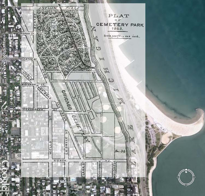
Chicago City Cemetery
A Jewish Burial Society bought six-sevenths of an acre in City Cemetery in 1846. Four years later, the city added 12 acres to its Cemetery by purchasing the adjacent estate of Jacob Milleman, a victim of Cholera. 
Built in 1858 for Ira Couch, costing $7,000, at the south end of Lincoln Park. The other above-ground tombs were removed, and all other bodies were reinterred shortly after the Cemetery was closed in 1869.
Citing the proximity of the burial grounds to the city's water supply as hazardous to public health, Chicago's sanitary superintendent, physician John Rauch, requested the abandonment of the city cemetery as early as 1858. Burials continued until 1866 when Chicago lost a lawsuit filed by the Milleman heirs, who claimed $75,000 was owed to them due to the mistake-ridden sale of 1850. The city chose to move the bodies to private cemeteries located outside of the city limits and return the land to the heirs. 

The Great Removal began. City Cemetery bodies were wagoned to Graceland, Oakwoods, Rosehill, and Wunder's cemeteries. The Roman Catholic choices were Calvary in Evanston and St. Boniface in Chicago. Jews had moved their burial ground to Belmont and Clark in 1856. 
Rosehill Cemetery Entrance, Chicago, Illinois (chartered February 11, 1859).

Chicago city government attempted to prohibit any new burials within the city of Chicago throughout the late nineteenth century. Yet, as the city annexed additional land, it contended with existing cemeteries inside its limits. Graceland, for instance, was situated two miles north of the city until the significant annexation of 1889.
Graceland Cemetery
The state of Illinois protected these private cemeteries from city bans on burials. Still, Chicago exercised some control over its extension by passing an ordinance in 1931 that made it unlawful for cemeteries to expand or change their boundaries without a special permit." 

An account of the laying out, by the town authorities of Chicago, in 1835, of two cemeteries, one on the Northside and one on the Southside. The Protestants used the Northside cemetery, while the Southside cemetery became the first Catholic burial ground in the city. 

No interments were made in the Southside grounds after 1842. In about 1847, the city authorities reinterred the bodies from the burial grounds in the Lincoln Park tract, known as Chicago Cemetery. The Chicago Cemetery tract contained 3,236 burial lots and was designated the "Milliman" tract under the old survey. By a decision of the Illinois Supreme Court, the city lost the title to the Milliman tract and the Common Council, in 1865, ordered the vacation of the parcel, authorizing lot owners to exchange their lots for lots in any of the new cemeteries, of equal size and of their own selection Graceland, Rosehill, and Oakwoods had, by this date been established. 

When the time allowed (two years) for the city to vacate the tract of land, the deadline expired. A special committee was appointed by the Common Council, consisting of Aldermen Woodard, Wicker, and Lawson, who selected about two hundred lot-owners who had not made any selection and could not be found. The committee selected lots of equal size and in the best obtainable location in that part of Oakwoods known as the "Third Division, Section B," where the bodies were reinterred in precisely the same order as they had been in the Chicago Cemetery. The city holds the title to the whole tract purchased in Oakwoods, and any of the exchanged owners were given the privilege of obtaining a deed to the new lot upon executing the release of the old one. After several years of litigation, the portion of the old Chicago Cemetery included in the present limits of Lincoln Park passed under the control of the park commissioners. Joseph H. Ernst, of No. 271 North Avenue, was the sexton of the Chicago Cemetery for several years and was charged with the bodies' exhumation.

The Jewish Congregations had a cemetery five miles north of the city on Green Bay Road (now North Clark Street). They formerly had a plat of ground in the Chicago Cemetery, and the Hebrew Benevolent Society established a burial ground here in 1855. The grounds are high, overlooking the lake, and contain several fine monuments. Sinai and Zion's congregations also had an extensive plat reserved at Rosehill Cemetery Company, chartered on February 11, 1859.

Wunder's Cemetery was founded in 1859 and was initially called The First German Lutheran or The Evangelical Lutheran Cemetery. The German Lutheran Cemetery was incorporated in 1912. On October 19, 1919, it was renamed Wunder's Cemetery Association to honor the Evangelical Heinrich' Henry' Wunder, pastor of First Saint Paul's Evangelical Lutheran Church. Members of this congregation, jointly with First Immanuel Evangelical Lutheran Church, were elected as the Directors of Wunder's Cemetery Association.

Graceland Cemetery was founded in 1861 by Thomas B. Bryan, who purchased eighty acres of land, five and a half miles from downtown, on rising ridges near the lakeshore. 

Oakwoods Cemetery lies three and a half miles due south of the city limits. It is reached by the boulevard drives through North Park, and Illinois Central Hyde Park trains stop at 67th Street, from whence a broad walk leads to the cemetery entrances. The Cemetery was laid out in 1864.

Forest Home Cemetery lies on the banks of the Desplaines River, four and a half miles west of Chicago, on Madison Street, and was founded in 1876.
Forest Home Cemetery. Circa 1890s
Waldheim Cemetery is directly opposite Forest Home Cemetery, to the south, between Harrison and Twelfth Streets on the Desplaines River. It is owned by a corporation re-organized in 1881 under the law 1879.
German Waldheim Cemetery. Circa 1890s
St. Boniface, a German Catholic Cemetery of about thirty acres, is located on Green Bay Road, three and a half miles north of the city (now North Clark Street). 

Calvary Cemetery was the favorite burial place of the Irish Catholic Churches. It lies nine miles north of the city near Evanston. It was consecrated shortly after the opening of Graceland Cemetery in 1861. However, before this, some of the bodies taken from the consecrated ground in the old Chicago Cemetery were reinterred here.

The early places, say up to the late 1840s, have been abandoned, and the deposits all removed to newer grounds provided by several cemetery associations of the city.

In 1893, the cemeteries east of the Desplaines River were in the Chicago City Directory. They are listed under their known names:
  • Anshe Maariv' Jewish' Cemetery. (N. Clark Street  and Belmont Avenue .)
  • Austro-Hungarian, [Waldhelm] Cemetery. (10 miles west of City Hall)
  • Beth Hamedrash 'Jewish' [Oakwoods] Cemetery. (67th St. and Cottage Grove Ave.)
  • B'nai Abraham' Jewish' Cemetery. (Near Waldhelm)
  • B'nai Shalom' Jewish' Cemetery. (N. Clark St. and Graceland Ave.) 
  • Calvary Cemetery. (9 miles north of City Hall)
  • Cemetery of the Congregation of the North Side. [Waldhelm]
  • Chebra Gemilath Chasadino Ubikar Cholim. (N. Clark St. near Graceland Cemetery)
  • Concordia. Cemetery. (Near Forest Home Cemetery, Oak Park)
  • Forest Home Cemetery. (Madison St., and Desplaines River, Forest Park)
  • Free Sons of Israel' Jewish' Cemetery. [Waldhelm]
  • German Lutheran Cemetery. (N. Clark St. and Graceland Ave.) 
  • Graceland Cemetery. (Clark St. and Irving Park Road) 
  • Hebrew Benevolent Society Cemetery. (Near Graceland Cemetery)
  • Moses Montefiore' Jewish' Cemetery. [Waldhelm]
  • Mount Greenwood Cemetery. (California Ave. and 111th St.)
  • Mount Hope Cemetery. (California Ave. and 115th St.)
  • Mount Olive Cemetery. (Narragansett Ave. and Addison)
  • Mount Olivet Cemetery. (California Ave. and 111th St.)
  • Oak Woods Cemetery. (67th St. and Greenwood Ave.)
  • O'Haney Emunah' Jewish' Cemetery. [Waldhelm]
  • O'Haney Shalom' Jewish' Cemetery. {Unknown}
  • Rosehill Cemetery. (Peterson and Ravenswood Aves.)
  • Sinai Congregational' Jewish' Cemetery. {Unknown}
  • St. Boniface Cemetery. (N. Clark St. and Lawrence Ave.)
  • Union Ridge Cemetery. (Higgins and Normandy, Norwood Park)
  • Waldheim' Jewish' Cemetery. (Roosevelt Rd. and Desplaines River, Forest Park)
  • Wunders Cemetery. ( 2280 N. Clark St., at Irving Park Rd., Chicago)
  • Zion Congregation Cemetery. (Peterson and Ravenswood Aves.) 
These were additional cemeteries east of the Desplaines River in the 1911 Chicago telephone directory. They are listed under their known names:
  • Bohemian National Cemetery. (Crawford Ave, North of Foster)
  • Elm Lawn Cemetery (Office: 172 East Washington, Chicago)
  • Elmwood Cemetery (Office: 293 North Carpenter, Chicago)
  • Mount Auburn Cemetery (Between Oak Park & Ridgeland Aves. near 39th St., Chicago)
  • Mount Mayriv (64th and Waveland Ave., Chicago)
  • Norwood Park Cemetery (Office: 84 La Salle St., Chicago)
  • Oakridge Cemetery (Office: 160 W Washington St., Chicago)
  • St. Adelbert's Cemetery (Milwaukee Ave., Chicago)
  • St. Lucas Cemetery (40th [Pulaski] and Foster Aves, Chicago)
Compiled by Dr. Neil Gale, Ph.D.