Tuesday, March 26, 2024

Kampsville, Illinois, is a Quaint Little Village of 300 on the Illinois River.

Kampsville was initially known as Beeman's Landing after James L. Beeman, a ferry operator on the Illinois River. After Stephen Farrow purchased the Ferry from Beeman, the name was changed to Farrowtown. The name "Vedder" was used when the post office was established in 1857. 


The name Kampsville was made official on March 6, 1872, and refers to Michael A. Kamp, who served as President of the village board and was also a postmaster at Silver Creek, north of Kampsville.

In 1863, German immigrant and Civil War veteran Captain M. L. Kamp moved into Calhoun County and set up a general store and post office in Silver Creek, just north of the site of present-day Kampsville. Kamp flourished as a farmer and merchant, and in 1869, Kamp purchased a tract of land south of Silver Creek and began to develop it. 

Initially named Farrow Town, the town was renamed Kampsville to honor Captain Kamp. The wealth and success of Kamp are reflected in the red brick home at the intersection of Routes 100 and 108 that he had built for his family in 1882.

In 1902, Captain Kamp gifted a newly constructed and completely supplied store, including one dollar in coins in the cash register for good luck to his son, Joseph A. Kamp. This store is one of the few surviving early commercial buildings in Calhoun County. The store was an important center of commerce for the County, and much of the business used the barter system, which allowed Kampsville to grow despite a shortage of money. Apples, peaches, lumber, and fish were traded at Kamp's store for supplies and later resold and shipped downriver to destinations such as St. Louis. The store was sold to the Capps family when Joseph Kamp died in 1952, and after several owners, it was acquired by the Center for American Archeology in 1991. 

Kamp and other European settlers weren't the first people to find the bluffs and rolling hill country an attractive place to live. The area is located in one of the world's richest archeological regions, with recorded human habitation dating back to the Early Archaic period (8500-6000 BC). Kampsville is home to the Center of American Archeology (CAA), which conducts ongoing excavations and educates future archeologists and the public. The CAA features exhibits and displays in its Visitor's Center, a museum facility in Kamp's Store, and its administrative offices in the Kamp family's former home.

The village of Kampsville is the base of operations for the Center for American Archeology, an educational and research organization dedicated to the archeological understanding of the Indigenous People and European settlers in the region. 

The Center of American Archeology building was added to the National Register of Historic Places in 1994. It contains exhibits demonstrating evidence of 7,000 years of human habitation excavated at the Koster Site, a prehistoric archaeological site in nearby Greene County.
The two ferries are FREE. There is 24/7 service.


The Kampsville Ferry crosses the Illinois River at Route 108, connecting the east side of the river in Green County and the City of Carrollton on Rt. 108, a two-lane undivided surface highway for its entire length. It is one of two permanent ferries operated by the Illinois Department of Transportation.

The town hosts many annual events, including Old Settlers Days and a series of educational events organized by the CAA. Just south of town on the Great River Road (Route 100) is the McCully Heritage Project, with 12 miles of nature trails and other recreational activities.

The village of Kampsville is the base of operations for the Center for American Archeology, an educational and research organization dedicated to the archeological understanding of the Indigenous People and European settlers in the region. It exhibits evidence of 7,000 years of human habitation excavated from 3 acres at the Koster Site, 11 miles due east, a prehistoric archaeological site in nearby Greene County. 

The Koster Site was discovered in 1967 on the farm fields of Theodore and Mary Koster and subsequently named after them. The discovery was made by Northwestern University (Evanston, Illinois) anthropologist Stuart Struever, who stumbled upon the farm and the rich trove of historically significant artifacts that lay beneath the cornfields after a tip from a local farmer. Struever had recently founded the Center for American Archeology, 101 Broadway,  Kampsville, Illinois. 

Compiled by Dr. Neil Gale, Ph.D.

Sunday, March 24, 2024

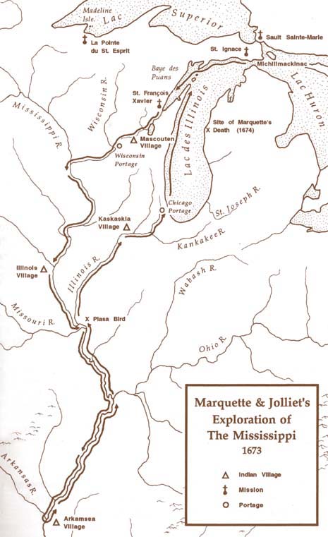
Marquette and Jolliet French Exploration of the North American Interior, 1673.

On May 17, 1673, Father Jacques Marquette and Louis Jolliet, a skilled cartographer and fur trader, set out on a four-month voyage that carried them thousands of miles through the heart of North America to explore the path of the Mississippi River. The Mississippi's vastness awe-struck them, and they recognized its potential as a major route for trade and exploration.

sidebar
Louis Jolliet likely met Father Marquette at the Jesuit mission at Sault Ste. Marie. Born near Quebec, Joliet had been destined for the priesthood when he decided to change course and become a fur trader.
 
 
Map of Marquette and Jolliet's exploration of the Mississippi River, 1673.


Their voyage helped to initiate the first non-Indian settlement in the North American interior that introduced Christianity into 600,000 square miles of wilderness, gave French names to cities in Wisconsin and Illinois, transformed traditional Indian cultures, and nearly exterminated the fur-bearing mammals of the Upper Midwest.

The two explorers were an unlikely pair. Father Jacques Marquette was a studious Jesuit two weeks shy of his 36th birthday. His partner, Louis Jolliet, was a 27-year-old philosophy and cartography student who had become a fur trader.

sidebar
The word "Mississippi" comes from the Ojibwe Indian Tribe (Algonquian language family) word "Messipi" or "misi-ziibi," which means "Great River" or "Gathering of Waters." French explorers, hearing the Ojibwe word for the river, recorded it in their own language with a similar pronunciation. The Potawatomi (Algonquian language family) pronounced "Mississippi" as the French said it, "Sinnissippi," which was given the meaning "Rocky Waters."

Marquette and Jolliet did not discover the Mississippi. Indians had been using the "Sinnissippi" for thousands of years, and Spanish explorer Hernan De Soto had crossed it more than a century before them. They confirmed that the native peoples who lived along the route were generally friendly and that the natural resources of the lands in between were extraordinary. Equipped with this information, French officials led by the explorer LaSalle would erect a 4,000-mile network of trading posts to systematically exploit those riches over the next century and a half.


They left St. Ignace at the head of Lake Michigan on May 17, 1673. They crossed Wisconsin between June 1 and June 17, then followed the Mississippi River hundreds of miles south to Arkansas.

sidebar
The five voyageurs (names unknown) were almost certainly of French-Canadian or Métis (mixed French and Indian) heritage. They were knowledgeable in wilderness survival, skilled canoeists, guides, and outdoorsmen, making them essential to the success of the expedition.

Two canoes carried seven, including Marquette and Jolliet, paddled by five unnamed voyageurs.


In June of 1673, Father Jacques Marquette, a Jesuit missionary, and Louis Jolliet, a fur trader and skilled cartographer, entered what is now the state of Illinois during their groundbreaking exploration of the Mississippi River. They began their journey in May from St. Ignace in present-day Michigan, intending to find the river's course and potential route to the Pacific Ocean. While their exact duration within Illinois borders is somewhat debated, they spent a significant amount of time exploring the region, likely staying roughly a month before continuing their trip in July.

As they paddled their canoes down the Mississippi, they made an essential encounter with members of The Illinois (aka Illiniwek or Illini) Confederacy. The Illinois comprised several Indian tribes consisting of the Kaskaskia, Cahokia, Peoria, Tamarais (Tamaroa, Tamarois), Moingwena, Mitchagamie (Michigamea), Chepoussa, Chinkoa, Coiracoentanon, Espeminkia, Maroa, and Tapouara tribes that were of the Algonquin family. They spoke Iroquoian languages. The Illinois called themselves "Ireniouaki" (the French word was Ilinwe).

These tribes were welcoming, and the explorers learned much about their culture and way of life. Marquette, fluent in several native languages, likely used his skills to communicate and foster peaceful relationships. The Illinois shared vital information about the river's course and warned of potential dangers downstream, including hostile tribes. 

The relationship between the explorers and the Illinois people were mainly friendly; they engaged in trade and shared information. Marquette, a Jesuit missionary, was keen to learn about their customs and languages while also seeking to introduce them to Christianity.

While in Illinois, Marquette and Jolliet meticulously documented the land they traversed. Marquette likely kept detailed journals of their observations, noting the abundance of wildlife, fertile soil, and diverse plant life they observed. As a cartographer, Jolliet would have carefully mapped out the landscape and river, creating valuable records for future French exploration. Marquette's journal is a valuable historical source offering insight into the geography, flora, fauna, and the lives of the Indians they encountered.

Despite the valuable knowledge and hospitality they received from the Illinois people, Marquette and Jolliet eventually decided to turn back. Rumors of conflicts further south and fears of encountering Spaniards convinced them that continuing the journey was too risky. They reasoned that they had discovered enough to confirm that the Mississippi River emptied into the Gulf of Mexico, not the Pacific Ocean. Thus, they began their return journey in July after a relatively short stay within Illinois' boundaries.

A significant part of their Illinois travels involved venturing up the Illinois River, a major tributary of the Mississippi. This fertile river valley was teeming with wildlife and rich agricultural potential. They likely encountered villages along the river banks,  interacting with more members of the Illinois Confederacy.

On September 30, 1673, they arrived at St. Francis Xavier Mission at modern DePere, Wisconsin.

Marquette and Jolliet's expedition solidified French claims to the territory, paving the way for later colonial expansion into the Mississippi River valley and the establishment of Illinois Country.


Complied by Dr. Neil Gale, Ph.D.