Tuesday, May 10, 2022

A Discovery of an Indian Effigy Mound in the Lake View Community of Chicago, May Date Before 1,000 AD.

Effigy mounds are sacred burial places built by Indians between 800 AD and 1,000 AD. They are extensive earthworks made from soil, usually about 3 to 7 feet high, forming shapes that can be seen from overhead. Some look like bears, and others resemble lizards or turtles.

Map of American Indian trails and villages of Chicago and of Cook, DuPage, and Will counties in 1804 was drawn by Albert F. Scharf 1900, a surveyor and cartographer who took an interest in Chicago’s 19th-century geography.
We'll look for evidence that a lizard-shaped effigy mound existed in Chicago's Lake View neighborhood, who built it, and why it disappeared. The answers to these questions illustrate how racism among early archaeologists prevented them from getting to the bottom of the effigies’ origins.
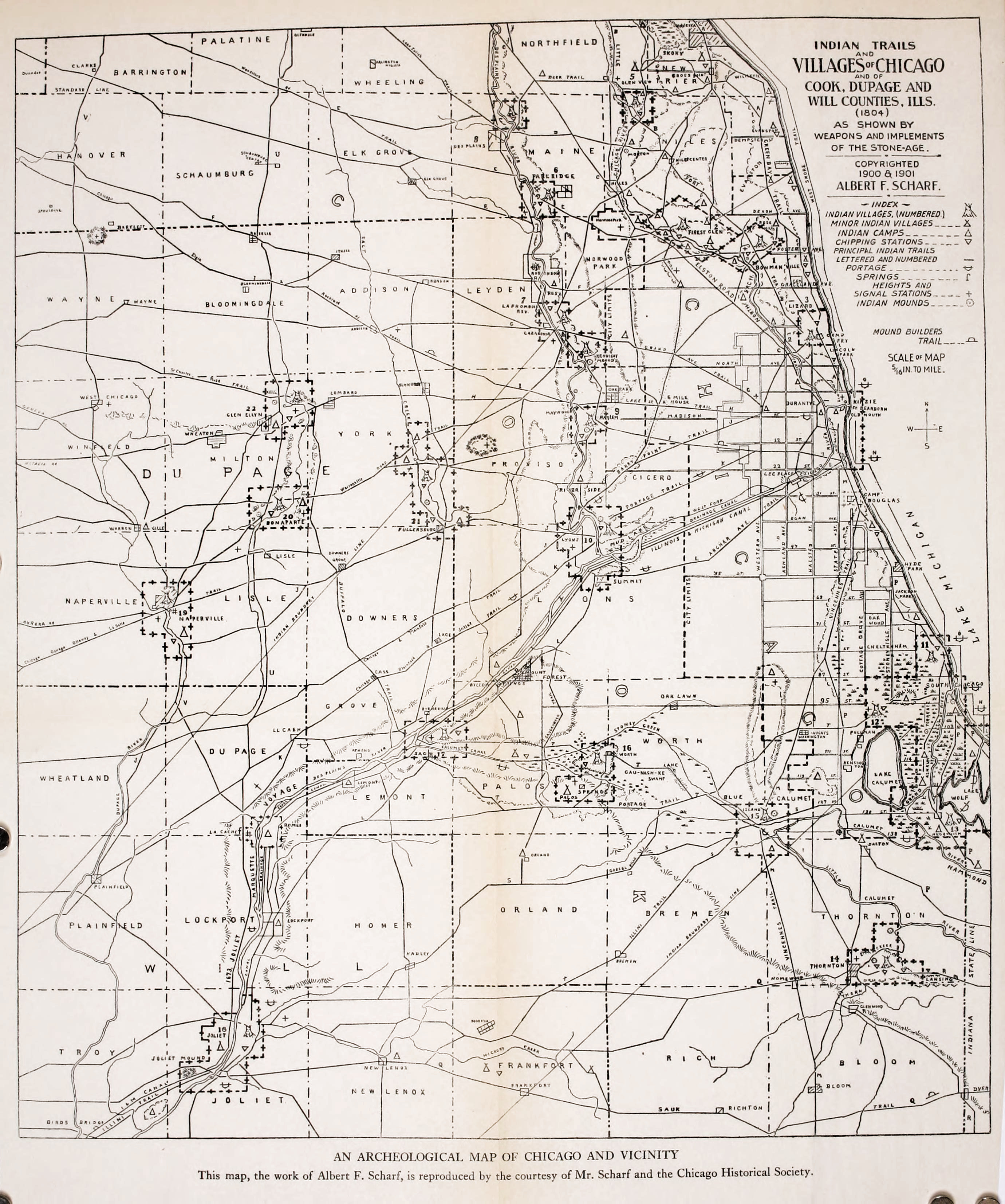
Scharf’s map shows the text 'LIZARD' (an “Effigy Mound"), located in Chicago's Lake View neighborhood. Effigy mounds are large earthworks made from soil that form shapes that can be seen from overhead.
Archeologists haven’t confirmed the existence of the effigy mound in Lake View, but there is some archival evidence of its location. 

The Scharf map reconstructed a landscape that had been vastly transformed from an area with a few villages and trails to a major city with several outlying suburbs and roads. Scharf relied on accounts from Chicagoans old enough to remember the area before 1833.

His source for the location of the lizard effigy mound was likely an artist and amateur archaeologist named Carl Dilg, who was obsessed with Chicago’s archaeological history and on a personal quest to document the ancient sites of Chicago. As he wrote in a private letter, Dilg wanted to make sure Chicago’s history was not “smothered and killed.”
The Chicago History Museum (formerly the Chicago Historical Society) has an extensive collection of Dilg’s papers, including notes he made from dozens of excursions to archaeological sites around Chicago in the 1880s and 1890s. They contain multiple references to a mound in Lake View, which he referred to as a “lizard” or a “serpent.” Dilg made several sketches of artifacts found near the mound and a map of the area now known as Lake View, showing the exact location of the mound, which you can see on his map.
In Dilg's sketch of the side profile of the lizard mound,
he compares it to another archaeological site in California.
But Dilg didn’t include a precise description of the mound’s length, width, or makeup.

Still, there seems to be significant circumstantial evidence that he’d actually seen it. For one, his depiction of the mound shows the head facing south and the tail facing north, as though the creature was walking south. This is consistent with other water spirit effigies that archaeologists have found in places like Wisconsin. Dilg’s sketches and notes also show the lizard-shaped mound had another round-shaped mound built adjacent to or directly on the “lizard.” This is consistent with the Potawatomi burial practice: The Potawatomi typically constructed conical burial mounds on the site of older effigy mounds. Finally, effigy mounds have been documented as close to Chicago as Aurora, so it’s possible effigy builders’ could have made it to Chicago.

But we know that there’s no lizard mound in Lake View today, so if it did exist, then what happened to it?

About 15 years after Dilg made his sketches, Charles Brown, a distinguished archaeologist from Wisconsin, visited Chicago to review Dilg’s extensive work. Brown wrote about Dilg’s observations, including one sentence about the Lake View effigy mound:

“A ‘lizard mound’ of doubtful origin was located on Oakdale Avenue and Wellington Street, under the present elevated station,” Brown wrote.

Brown’s notes suggest there was some kind of mound that was probably destroyed by the construction of the elevated train line that eventually became the Chicago Transit Authority’s Brown-Line. His use of the phrase “of doubtful origin” suggests Brown, a leading expert on effigy mounds at the time, doubted the mound in Lake View was a true effigy mound like those 800 to 1,200-year-old mounds in Wisconsin.

But archaeologist Amy Rosebrough says Brown has “been known to be wrong.” Brown’s doubt may simply reflect his own disdain at Dilg’s amateur approach to archaeology or his belief that Chicago was not part of the effigy mound builders’ territory, Rosebrough says.

Without a more complete record, Rosebrough and other archaeologists cannot verify if the Lake View mound was an authentic effigy mound or merely a lump of earth that Dilg’s romantic imagination transformed into an ancient sculpture.

If we assume Dilg was correct and the Lake View mound was, in fact, the same kind of effigy mound found in Wisconsin, that raises another critical question that scholars and archaeologists have been asking for 200 years: Who built it?

Early American archaeologists believed the mounds may have been built by a mysterious “lost race” of “mound builders,” sometimes thought to be an earlier Native American civilization connected to Mayan, Aztec, or Incan cultures. Some have theorized the mound builders weren’t indigenous to the Americas, but instead, they were a lost tribe of Israel or a traveling culture, like the Phoenicians or Egyptians.

These hypotheses, which range from unlikely to absurd, reveal a bias common among white Americans in the 19th century: They didn’t believe contemporary groups like the Ho-Chunk, Potawatomi, or Ojibwe, who all lived in areas with effigy mounds, were sophisticated enough to build them.

Richard C Taylor, a writer who traveled through Wisconsin in the 1830s, was typical of the time. He wrote:

“But to a far different race, assuredly, and to a far different period, must we look when seeking to trace the authors of these singular mounds. … But who were they who left almost imperishable memorials on the soil, attesting to the superiority of their race?”

This prejudice made archaeologists slow to accept the idea that these mounds were built by the ancestors of the Indians who lived near the mounds. But eventually, beginning in the early 1900s, American archaeologists began a more deliberate effort to talk with Native Americans about effigy mounds. Charles Brown and Paul Radin, two Wisconsin-based archaeologists, documented extensive conversations with Ho-Chunk people (then known as the Winnebago tribe).

The current consensus among archaeologists is that the mounds were built by several tribes or groups who might have been closely related and treated mound building as a ceremony. Archaeologists believe the Ho-Chunk of Wisconsin is one of several tribal groups descended from people who built effigy mounds, including the Iowa and Winnebago of Nebraska.

Over the years, the Ho-Chunk have claimed to be the descendants of effigy mound builders. In an interview with the Portage Daily Register in 2016, Bill Quackenbush, the cultural resources officer for the Ho-Chunk, said he prefers not to explain the significance of the mounds to outsiders. He said people should try to appreciate the mounds rather than analyze and understand their exact meaning.  
Digging into effigy mounds was a popular pastime during the late 19th century.
“The culture we live in today and society 100 years ago, they tried to do that,” he said. “They dug through them, took screens out there, shook the dirt, and looked for every little piece of information found. They couldn't find what they were trying to get. They had a preconceived notion in their heads already.”

So early settlers destroyed hundreds if not thousands of ancient sculptures, along with the historical record. They plowed under mounds to farm the land or leveled them and built homes on the sites. In some cases, early settlers claimed to have asked local Native Americans about the origins of the mounds without receiving a clear answer.

John Low, a Potawatomi Indian, and professor of American Indian studies, says he’s suspicious of these accounts, given that they took place during a power struggle over land.

“The natives may have said that because they aren’t going to share with people, they regard as the enemy, the specialness they know about a site.” Or, Low suggests, the white settlers may have displayed selective memory.

“We may have been written out of the narrative,” he says. “If the knowledge the natives have about these sites had been transcribed, gosh, that sounds like the natives have more of a claim, and it sounds icky to walk them out to Kansas or Oklahoma.”

By the late 1800s, when Indians were no longer seen as a threat to westward expansion, white Americans became interested in many aspects of their culture, including effigy mounds. But that interest was not necessarily respectful, especially considering mounds often contain human remains, and archaeologists felt free to dig through burial sites and take home human remains for display. Amy Rosebrough describes the popular pastime of “mounding”:

“You take a family out on a picnic and give the kids a shovel and bucket, and they would dig into a mound and see what was there.”

Unless we find new evidence in an archive somewhere (perhaps missing pages from Carl Dilg’s manuscript), Lake View's “lizard effigy” will remain a mystery. That’s because so much of the historical record was lost when the mounds were destroyed, says scholar and Potawatomi Indian John Low. As a Native American, he feels like the destruction of the mounds represents a desecration and willful disrespect of his culture. But he also sees a universal human tragedy.

“It’s something we should all feel sad about when they’re lost,” he says. “Like when the acropolis is lost. Or the pyramids. Or Stonehenge is lost. These, too, are part of the human record of achievement. What a shame.”

ADDITIONAL READING:

The History of the Chicago Claim Company Restaurant, 2314 North Clark Street, Chicago, Illinois.

The story of the Chicago Claim Company, 2314 North Clark Street, goes back to 1973. 
Created by Jim Errant at Clark and Belden on Chicago's Northside, the restaurant became an instant hit. It is known throughout the area for two new restaurant concepts: the build-your-own gourmet burger and the Salad Saloon. The decor follows a southwestern theme, perfect for a restaurant where the burger came to be called the "Motherload."
This is an actual Miners Pan Menu from The Chicago Claim Company Restaurant, signed by artist James Hribar. It depicts a Miner with his pan and a donkey behind him. The award sticker is dated 1974. It's 16" in diameter and 4" deep.
Who's up for a food challenge? Can you eat a 3½ pound burger and all the [house-made] chips? In 45 minutes?


Chris Lilja, Libertyville, Illinois, did it in 36 minutes in November 2015.


In 1979, the Claim Company put down stakes in the suburbs, opening the relatively new Northbrook Court shopping center in Northbrook, Illinois. Designer Spiro Zakas created a futuristic version of the Chicago restaurant's southwestern concept. While the Northbrook location was much larger than the Chicago restaurant, the new site still needed to be more significant to handle the crowds. Wait times were usually about an hour for lunch and dinner. 
Since the mid-1970s, my "Regular" at the Chicago Claim Company has been a Hamburger cooked medium with Cheddar Cheese, Tomatoes, fried onions, and Teriyaki Sauce on an Onion Roll, plus a side of Teriyaki. Every Time.
From the Private Collection of Dr. Neil Gale.


In 1981, the Claim Company moved West to the Oakbrook Center. It was the group's largest restaurant and quickly became a hot spot.

Jim Errant's success attracted national interest, and in 1994, he sold the Claim Company to an East Coast company with plans to expand outside the Chicagoland market. The Claim Company continued to thrive during the 1980s and into the 90s. The buyers' expansion plans never came to fruition, and the Claim Company closed its doors in 1998.


Loyal customers and the former owner mourned its loss. In the autumn of 2009, they opened a new version, The Claim Company, dropping Chicago from the name in Northbrook Court. In designing the new restaurant's look, they drew inspiration from its previous three locations. Stepping through the doors should feel like a homecoming.
Northbrook Court, Northbrook, Illinois.


The Claim Company opened in the Hawthorn Mall, 506 Hawthorn Center, Vernon Hills, Illinois.


Compiled by Dr. Neil Gale, Ph.D.

Monday, May 9, 2022

Lost Towns Of Illinois - Daggert, Illinois.

Daggert, Illinois, (Daggett [1]) was a small community in Carroll County located approximately 5 miles south of Mt. Carroll on the east side of today's Illinois Route 78. Daggert existed as a town briefly in the late 19th and early 20th centuries, reaching a peak permanent population of 25 around 1910. In its heyday, the town had a post office, a church, a railroad depot, a one-room schoolhouse, a blacksmith, a hand full of small stores, and a church, all serving the surrounding Salem Township farmers. By the early 1960s, the town had disappeared.

Adam Daggert, his family, and some friends arrived in Carroll County in the early 1830s. He settled near what is now Timberlake and Daggert roads [Satellite Map], listed today as in Mt Carroll, sometime in the 1830s. He built a house on the homestead and began farming the land.

Daggert donated some property for a church; today it's the lot that Trinity Lutheran Church now occupies. He platted a small lot to build a cemetery and buried the three wives he outlived and his Kin.

The Adam Daggert Cemetery in Mt. Carroll, Carroll County, Illinois, holds nine Daggert family members, sorted by year of death:

Anna Katharina Weitzel Daggert (Sep 8, 1817 – July 12, 1849)
    Anna Elisa Daggert (Aug 1819 – Feb 1866)
       A William Daggert (May 1, 1868 – Nov 19, 1868)
          John B Daggert (Nov 20, 1869 – Apr 19, 1872)
             Adam Daggert (Aug 24, 1809 – May 2, 1879)
                Margaretha Daggert (May 1823 – Mar 1879)
                   John Daggert (Dec 29, 1842 – Mar 4, 1920)
                      Clara K Daggert (Dec 27, 1879 – Jun 19, 1939)
                         Katherine A Daggert (May 30, 1877 – Jun 21, 1956)

Adam built a one-room schoolhouse to educate his five children. The Daggert School remained active, according to Carroll County registration records, through at least 1948. 

Upon Adam's death in 1873, his two oldest sons divided the property. Walter, the younger son, kept the parcel with the family house on it while Henry, the older son, took the western half of the property.

Henry's land was adjacent to a trail that ran to Mt. Carroll, the county seat, five miles north. The big, ridged hill in the northwest corner of the farm, with several creeks cutting through it, reduced the amount of arable land (capable of being plowed and used to grow crops). Henry cleared part of the hilltop to open access to another field. He built a house on the homestead along a road running along the northernmost property line, a short walk away from his brother's farm.

In the mid-1800s, with a sturdy teem carriage, on a dry day and with the road in good shape, it would take around an hour to get to Mt. Carroll from Henry's homestead. Mt. Carroll was the nearest post office and the county seat. With a railroad connection and college, Mt. Carroll was home to several merchants and small manufacturing firms. But most Salem Township residents couldn't afford a fine carriage, and most walked or drove farm wagons into town when they could. A trip to Mt. Carroll could easily take an entire day during the winter and spring thaw if mother nature allowed it.

Before Rural Free Delivery (RFD) [2], which first appeared in 1896, it was common for contractors to arrange for mail pick up for a fee. The contractor would bring the mail to his place, sort it, and notify the recipient when they had packages or letters to pick up. This service would save many miles for communities far away from the U.S. Post Office. 

Adam Daggert had done this starting in the 1830s. Before founding the Mt. Carroll post office, he would pick up mail from Polo, Illinois, the closest office at the time. Adam did not read English, so he would leave the mail and packages in a pile for his neighbors to sort out. Henry also supplemented his farm income with mail contracting and running a small local store.

Meanwhile, hundreds of miles away, and without his help, events would change Henry’s store into something much bigger. The Pacific Railway Act of 1862 (for building the transcontinental railroad) defined three cross-country rail corridors, starting on the West coast and ending at a major mid-continent river. The Act was written for a world where river traffic was king, but by the late 1860s, all three lines needed a rail connection to the east. The Union Pacific built and bought lines for a connection to Chicago. The Southern Pacific met the Mississippi at New Orleans, which already had connections to Chicago and the East. But the only connections available to the Northern Pacific, completed in 1883 and ending at the Mississippi in Minneapolis, were via one of two competing railroads, both able to adjust pricing to rout freight and passengers over their own lines bypassing the Northern Pacific.

The Northern Pacific needed a route to Chicago to avoid being isolated from eastern markets. Northern Pacific took control of the Burlington railroad (Chicago, Burlington, and Quincy) to build a route from Aurora to Minneapolis, Minnesota. The Burlington consolidated smaller railroads they already owned in Illinois, and other lines on the east side of the Mississippi into the Burlington & Northern Railroad were purchased. To close a nearly ninety-mile gap between the Chicago area railroads and the river, they built a line in 1886 across northwestern Illinois, from Rochelle to the Mississippi River at Savanna, Illinois. From conception to completion, the construction took a little over a year. With no time for fancy engineering, the new route ran along river valleys and flatlands next to East Johnson Creek in Carroll County. The new railroad cut diagonally through Henry's property, following the creek near the base of the hill where he lived.
This photograph of Daggert Station was taken around 1900. The gentleman in the foreground is identified as Henry Daggert.
The railroad agreed to build the “Daggert Station.” Henry plotted a village at the high point overlooking the tracks, and he even marked the exact location for his future store.
An 1893 map of Salem Township showed the location of the shops and the Daggert station in Daggert. In exploring the property in the late 1960s, I found several old, shallow foundations in the area marked "Stores" The triangular slice of property containing the town still exists.


Henry's application for a Daggert Post Office was granted, with Henry Daggert named the first postmaster. The Daggert train depot housed the post office.

When the Burlington & Northern line opened in 1886, Daggert was a regular stop for four passenger trains daily, two eastbound and two westbound, connecting it with Chadwick, Rochelle, and Chicago to the east and Savanna, Illinois, and Minneapolis, Minnesota to the west.

This 1893 map shows Daggert's property with a road running east from today's Highway 78, leading to Henry's homestead and connecting to the road to his brother's home. Close to today's highway, the map is labeled "Stores" along the route. In 1969 I lived on the property, and while exploring behind my house, I found several shallow (18 inches deep) 10x10 foot foundations, some rock-walled, lining both sides of a clear broad path in this same area. I believe they were remnants of the town's shopping and residential area.

Census data from the period suggests that Daggert reached its peak population shortly after the turn of the 20th century. The town itself was never clearly broken out from Salem township data. A review of occupations in the enumeration district shows that the number of non-farm workers peaked in the 1910 census, most of them counted in the area near Henry's farm that corresponded to the town of Daggert. There appear to have been two merchants (one was Henry's son John), a milliner, a teacher, two ministers, a doctor, two lawyers, a banker, a real estate agent, and a blacksmith. About a dozen railway employees were listed, primarily laborers, although one was a railway telegrapher. A resident self-identified as a hotel clerk, suggesting there must have been some lodging.

The decline of Daggert from this point on is told by the railway's schedules and timetables and explains how Daggert disappeared.

In 1909 the trains that stopped at Daggert were cut to two per day. Later, the route was demoted to Chicago to Savanna mixed line, passenger and freight, and ending direct trains to Minneapolis and the west. In 1915 the schedule was cut to one train a day, and by 1924, Daggert was reduced to a flag stop.

As late as 1927, there were still two general merchandise stores in the town. On November 26, 1927, the Thomson Illinois Review reported that Daggert's store was held up by two "yeggs" (a burglar) the previous Saturday night at closing time, and their take was $12.00 ($200 in 2022).

In the early 1930s, Burlington realigned their right of way, moving it to a newly laid track on the property's north boundary, shortening the route. The old right of way was abandoned, and the Daggert depot was not moved to the new tracks. Although it appeared for years in Burlington's list of stations, Daggert was no longer an actual Burlington stop. The creation of the new tracks doomed Henry's farm.

Census data also marked the town's decline. The number of non-farm occupations decreased from the 1910 census and all the censuses that followed. By 1940, only one merchant, a general storekeeper, was listed. The rest of the residents were non-farm occupations, except for a teacher and a minister, who had apparently left the area.

In 1907, just before rural free delivery (RFD) started in Illinois, the Daggert post office was merged with Mt. Carroll's post office, and the Daggert office was closed.

Henry passed away in 1912. Of his ten children, only one daughter had ever married. The remaining sons and spinster daughters soldiered on, but when they were gone, the farm was gradually disassembled with no progeny (descendants), and the land sold piecemeal. John, the merchant, passed in 1935.

A triangular 13-acre parcel of land was defined by Illinois Route 78 to the west, the new Burlington right of way to the north, and the old right of way to the south containing an old country store and some old foundations was all that was left of Daggert.

One store continued, run by the Hartman brothers, continued business through at least the 1950s. Henry's leveled field north of the building, which he turned into a baseball field in an attempt to make Daggert a destination and, by the late 1930s, became the first lighted baseball field in northwestern Illinois. Eventually, the property was sold to a gentleman from Thomson, Illinois, who converted the building for residential use.

The triangular property that was once the site of Daggert's has been redeveloped into a more extensive private residence. After nearly collapsing in the early 1970s, the old store building was rebuilt and painted, and the structure was stabilized. A new house was built behind it, in the area where I had found the old foundations. The streams in the back of the property have been dammed, creating an artificial lake. The old baseball field is green, mowed, and young trees and a garden were planted.

Author's Note: In the late 1960s, I taught elementary school in a rural area south of Mt. Carroll. I rented the old store building and the associated property as my residence. While living there, a close friend and former roommate living in the area, John MacDevitt, introduced me to the local farmers, some of them descended from the original settlers. They were the ones who first told me about the old town that once had existed at the site where I lived. Their stories, some verifiably true, others quite fantastic, started me on a lifelong interest in documenting Daggert's history.

By Ken Molinelli, amateur historian, storyteller, and former Daggert resident.
Edited by Dr. Neil Gale, Ph.D.


[1] "Daggett" - The Burlington Railroad misspelled the station name as "Daggett" in its original train schedule, an error that was carried forward from 1886 until the station was abandoned.

[2] Rural Free Delivery (RFD) service began in the United States in 1896 to deliver mail directly to farm families. Before RFD, rural inhabitants had to pick up the mail themselves at sometimes remote post offices or pay a local private express company to pick up their mail and packages from the post office and deliver it to their door.