
Noble sold his land to a New York family (Charles T. Race and four other relatives that comprised the Irving Park Land and Building Company) and moved to McHenry County to farm in 1869.
With the land so close to the Chicago & North Western (C&NW) railroad, Race realized there would be more profit in beginning a settlement instead of overusing the land for farming and began building houses.
The original name chosen for the new suburb was "Irvington" after the author Washington Irving. It was discovered that Irvington was a village in Washington County, Illinois, had already used the name first, so the name Irving Park was adopted. After Race paid for a depot, C&NW agreed to stop at the settlement, which was soon renamed Irving Park.
Race built himself a three-story brick house with a basement and “French roof.” Joined by associates, he organized the Irving Park Land Company, bought additional land, and subdivided it into lots. Advertisements promoted the area's easy access to downtown via hourly trains. Boasting an idyllic setting comparable to that of suburbs such as Evanston and Oak Park, the ad pointed to Irving Park’s “shady streets, fine schools, churches and stores,” and homes of varied designs. The Irving Park subdivision was followed by Grayland, Montrose, and Mayfair subdivisions.
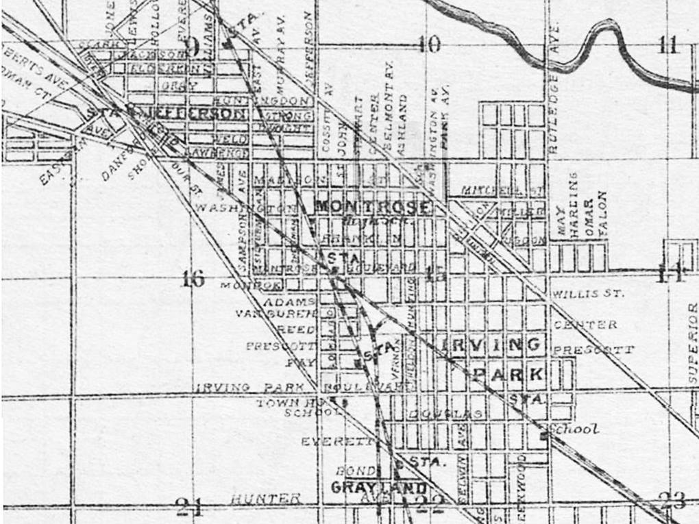
Grayland, a suburb of Chicago annexed in 1889, was created by subdividing John Gray's 80-acre farm. Gray deeded the land that he had already built a depot (the second one) on the Chicago, Milwaukee & St. Paul Railroad line. In return for the property, the R.R. promised to maintain and service the depot, thus ensuring that the inhabitants of Gray's subdivision would have easy transport to Chicago and back. The station was opened in 1873 to service Grayland.
The commuter suburb attracted many wealthy residents who sought larger homes of between seven and ten rooms and amenities that included closets and drinking water from artesian wells. Race and his associates garnered a 600% profit on the land. Other residents who were less affluent came to the area to remove their families from the dangers of the city. Rich or middle-class, the population of Irving Park was generally native-born, Protestant, and white-collar. They participated in community events and activities of a literary and musical nature. Both men and women were active in neighborhood organizations. The Irving Park Woman's Club was formed in 1888 with an agenda of cultural and reform activities.
Suburban paradise was not without problems, however. In the 1880s, heavy rains produced floods, and poor drainage turned unpaved streets into mud. In 1881 complaints were heard of raw sewage floating down Irving Park Road from the Cook County Poor House and Insane Asylum in Dunning.
 |
| The Irving Park Tea Store at 3613 Irving Park Road in Chicago. 1910 |
Irving Park was annexed to Chicago in 1889.

Compiled by Dr. Neil Gale, Ph.D.
Very interesting and informative article. I'm of German heritage and find this even more interesting.
ReplyDeleteThe building on the corner -the last picture is still standing
ReplyDeleteHi, I'm interested in learning more about the Irving Park Tea Store. Do you have more information you could share?
ReplyDeleteI live in this neighborhood and would love to learn more about it when my home was built in 1911. How can I do that?
ReplyDeleteMy parents lived at 3817 n Keeler, for over 40 years. The house was built 1879 and was a boarding house back in the day. Sadly the house was sold, torn down and a new house was built.
ReplyDelete