

Much later, the polar ice cap crept four times down across the continent, covering the region with ice to a depth of a mile or more. As the climate changed, the ice melted, the last great ice flow, the Wisconsin Glacier of the Pleistocene period, which covered much of the northern half of North America, retreated, and an outlet for the melting water developed through the Sag River and the Des Plaines River Valley around Mt. Forest, in the area known as the Palos.
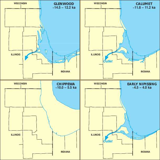
The Kankakee Torrent poured through those valleys, eventually leaving behind the prehistoric Lake Chicago or Glacial Lake Chicago, the term used by geologists for a lake that preceded Lake Michigan when the Wisconsin Glacier retreated from the Chicago area, beginning about 14,000 years ago.

Lake Chicago's level, at its highest, was almost 60 feet higher than the level of present Lake Michigan, and the lake completely covered the area now occupied by Chicago. Its northern outlet into the St. Lawrence River was still blocked by remnants of the glacier. It drained through the so-called Chicago outlet, a notch in the Valparaiso moraine[1], into the Mississippi system. Its western shores reached to where Oak Park and LaGrange now exist.
 |
| LAKE CHICAGO |
 |
| This undated marker is located in the southern portion of Lincoln Park, on the footpath paralleling the east side of Stockton Drive. A second identical marker is located on the same ancient beach ridge 485 feet East-North-East from the first one. |
HOW LAKE MICHIGAN GOT ITS NAME
The first Europeans to see Lake Michigan were French traders and explorers in the 1600s. One of which, Samuel de Champlain (1567-1635), who mapped much of northeastern North America, called Lake Michigan the Grand Lac. It was later named "Lake of the Stinking Water" or "Lake of the Puants," after the people who occupied its shores.
In 1679, the lake became known as Lac des Illinois because it gave access to the country of the Indians, so named. Three years before, Claude-Jean Allouez (1622-1689), a French Jesuit missionary, called it Lac St. Joseph, by which name it was often designated by early writers while others called it Lac Dauphin.
Another story recounts that Jean Nicolet, the first European to set foot in Wisconsin in 1634, landed on the shores of Green Bay and was greeted by Winnebago Indians, whom the French called "Puans." Lake Michigan was labeled as "Lake of Puans" on an early and incomplete 1670 map of the region that showed only the lake's northern shores. However, only Green Bay is labeled as "Baye de Puans" (Bay of the Winnebago Indians) on maps from 1688 and 1708. On the 1688 map, Lake Michigan is called Lac des Illinois.
 |
| Jesuit map of Lake Superior (or Lac Tracy) and Lake Michigan (or Lac des Illinois). Map by anonymous cartographer, 1671. |
Compiled by Dr. Neil Gale, Ph.D.
[1] Moraines are accumulations of dirt and rocks that have fallen onto the glacier surface or have been pushed along by the glacier as it moves.
Thank you, very interesting!
ReplyDeleteThis old guy moved to the WI shoreline several years ago. This information provides great information!
ReplyDelete