
From my years of researching and writing about Chicago and Illinois, I've come to the conclusion that too many Chicagoans just don't know.
Have you ever visited Oak Street Beach, Rush Street, the John Hancock Center, Navy Pier, or Grant Park? How about the Art Institute, Soldier Field, the Planetarium, Shedd Aquarium, Field Museum, or the Museum of Science and Industry?
If you answered yes to visiting any of these famous Chicago spots, you were on the east side of Chicago.
Chicago's "East Side" is also one of the 77 official community areas of Chicago.
HOW CHICAGO STREETS WERE NUMBERED IN 1875.
The city comprises Three Grand Divisions, known as the North, South, and West Divisions.
State Street is the main artery to the South Division. North Clark Street is the main artery to the North Division. Madison, Randolph and Lake streets are the main arteries to the West Division. On any given street, the relative location of a particular place or house is got by running down the column of figures, which are its numbers at the several crossings of the streets that intersect it. For example, to find 44 State Street, it will be seen that 24 is on the corner of Lake and 62 is on the corner of Randolph; hence, 44 is between these two streets. Where no numbers are given, the corners, and often the blocks, are vacant or occupied by a house or manufactory not numbered.
THE TRUTH ABOUT CHICAGO'S EAST/WEST SIDES.
An ordinance passed by the Chicago City Council on June 22, 1908, amended on June 21, 1909, and took effect on September 1, 1909, established the street numbering grid system now used in Chicago.
HOW CHICAGO STREETS WERE NUMBERED IN 1909. The ordinance made Madison Street, from the lake to the city limits, the baseline for numbering north and south streets. For east and west streets, the baseline was State Street or an imaginary line extended from State Street's northern terminus through Lincoln Park and the lake.
 |
| CLICK FOR A FULL-SIZE MAP |
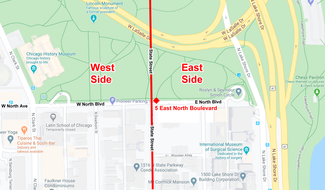
NOTE: The U.S. Postal Service delivers mail addressed with the direction "East." The example I used in the map below is 5 E. North Boulevard, Chicago.
Numbers began with #1 at State Street and went east and west from there, 800 numbers to the mile. In like manner, numbers on the north and south streets were figured from Madison Street. One number was assigned to every twenty feet of frontage on a street.
Even numbers were on the north side of the east and west streets and on the west side of the north and south streets.
NOTE: North Avenue east of Clark Street is called North Boulevard.
NOTE: Between Madison Street and Roosevelt Road (Twelfth Street), 1,200 numbers were used in one mile. Between Roosevelt (Twelfth Street) and Cermak Road (Twenty-second Street), 1000 numbers were used in one mile, and from Cermak (Twenty-second Street) to Thirty-first Street, 900 numbers were used in one mile.
By Neil Gale, Ph.D.
Even numbers were on the north side of the east and west streets and on the west side of the north and south streets.
NOTE: North Avenue east of Clark Street is called North Boulevard.
 |
| CLICK FOR A FULL-SIZE MAP |
By Neil Gale, Ph.D.