Friday, May 4, 2018

The History of Chicago Historical Society and Buildings.

The Chicago Historical Society (now named the Chicago History Museum) was founded in 1856 to study and interpret Chicago's history. Much of the early collection of the Chicago Historical Society was destroyed in the Great Chicago Fire in 1871, but like the city, the society rose from the ashes. Among the many documents that were lost in the fire was Abraham Lincoln's final draft of the Emancipation Proclamation.

After the fire, the Society began collecting new materials, which were stored in a building owned by J. Young Scammon, a prominent lawyer and member of the society. However, the building and new collection were again destroyed by the Chicago fire of 1874.

The Chicago Historical Society built a fireproof building on the site of its pre-1871 building at 632 North Dearborn Street (700N, 100W) at the NW corner of Ontario Street built-in 1892 by Henry Ives Cobb. 
The replacement building opened in 1896 and housed the Society for thirty-six years. The building was later added to the National Register of Historic Places as the Old Chicago Historical Society Building.
The Third Chicago Historical Society Building.
Charles F. Gunther, a prominent Chicago collector, donated some items to the Society. In 1920, the Society purchased the remainder of the large history collection from his estate, with the intention of changing its focus from only a research institution into a public museum. Many of the items in Gunther's collection, in addition to Chicago, were related to Abraham Lincoln and the American Civil War. These include Lincoln's deathbed, several other pieces of furniture from the room where he died in the Petersen House, and clothing that he and his wife Mary Todd Lincoln allegedly wore the evening of his assassination. The collection also contains the table on which General Robert E. Lee signed his 1865 surrender to General Ulysses S. Grant, an official act which ended the American Civil War, at the McLean House in Appomattox, Virginia.

After 36 years on Dearborn Street, the Society moved to the current structure in Lincoln Park. The current home of the museum was designed by Graham, Anderson, Probst & White and constructed in 1932 by the WPA, with the aim of creating an expanded public museum.
The Forth Chicago Historical Society Building.
The 1932 Federal-style structure has been expanded twice. The first addition clad in limestone opened in 1972 and was designed by Alfred Shaw and Associates. The second addition was designed by Holabird and Root, which was built in 1988 and included refacing the earlier expansion in red brick to give a unified look to all three portions of the building. Both expansions occurred on the west side of the 1932 structure, leaving intact its original porticoed entrance facing Lincoln Park.
The Current Look of the Third Chicago Historical Society Building.
The main entrance and reception hall, however, was moved to the new western addition facing Clark street. The 1988 extension, in addition to expanded exhibition galleries, also contains the museum's store and a public cafe.

The Chicago Historical Society changed its name to the Chicago History Museum in 2006.

Compiled by Dr. Neil Gale, Ph.D. 

The Original Art Institute building, at Michigan Avenue and Van Buren Street. The Chicago Club.

The Chicago Club, 404 South Michigan Avenue at Van Buren Street. This Burnham and Root building was built in 1886/87. The original tenant was the Art Institute.
Art Institute of Chicago, 1890
In 1893, the Chicago Club decided it needed larger quarters, and it purchased from the Art Institute of Chicago it's former building on the corner of Michigan Avenue and Van Buren Street. 

The Chicago Club was organized in 1869 as an outgrowth of the old Dearborn Club located on Michigan Avenue near Jackson Street. The first clubhouse of the Chicago Club was situated at the corner of Wabash Avenue and Eldridge Court. It was destroyed in the Great Chicago Fire in 1871The present building was erected shortly afterward. 
Chicago Club, 1906
The structure is not as magnificent as some of the club buildings erected more recently, but the interior is beautifully and tastefully arranged. There is more real elegance about it than, perhaps, may be found in any of the others, although it is of an unostentatious character. The dining rooms and kitchens are on the top floor of the building. The Club is composed generally of the merchants and leading professional men of the city and was very exclusive.
Chicago Club stairway around 1892.
Comfort and congeniality more than crowds and confusion are desired. The admission fee was $300 ($5,600 today), the annual dues were $80 ($1,500 today), payable semi-annually. Membership is limited to 450 residents and 150 non-residents.

This building remained the clubhouse until 1929, when it collapsed during remodeling.

Compiled by Dr. Neil Gale, Ph.D. 

Thursday, April 26, 2018

South Water Street, Chicago, beginning in the 1830s.

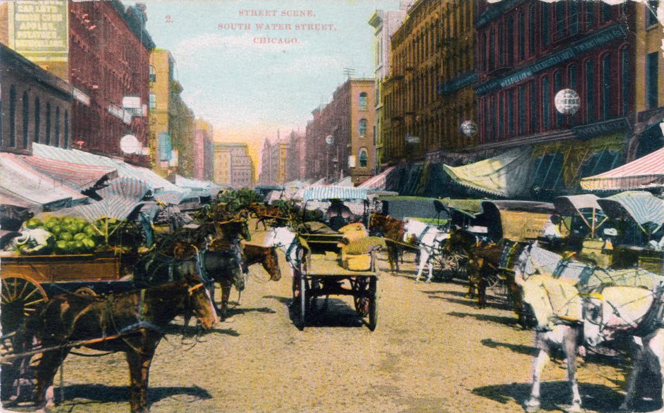
This is a rare view looking west on South Water Street, possibly in the early 1830s. Hogan's store was at South Water and Market Streets, while Wolf Point Tavern can be seen in the distance. (from a painting owned by the Chicago History Museum.)
The very first street Chicago ever had was a muddy, narrow trail running east and west along the south bank of the Chicago River, and its name described it as South Water Street. Along this street, the first markets and general stores were built, eventually becoming a gigantic produce market, only to be replaced by what is known today as West and East Wacker Drive. 

In 1833, when Chicago received its charter as a village, Lake Street was the town's main street; this same year, the first Tremont House was erected at the northwest corner of Dearborn and Lake streets. The first store building on Lake Street, a two-story frame structure, was built by Thomas Church. The first Court House followed in 1835, and the City Hotel, later the Sherman House, in 1837. From 1837 to 1842, the first City Hall was located in the Saloon building.
The "Saloon Building" was a three-story brick building erected in 1836 by Capt. J.B.F. Russell and George W. Doan at the Southeast corner of Clark and Lake streets. It was named after the French word salon, meaning a small reception or meeting hall, not a drinking establishment.


One of the country roads that came into the old Fort Dearborn settlement from the northwest was an Indian trail that was planked by the early settlers of the area to hold their wagons up from the bottomless mud. It was called the Northwest Plank Road. The original Indian trail name was the Milwaukee Trace, now known as Milwaukee Avenue.

The first road, crossing the "Dismal Nine-Mile Swamp," went west on Madison Street to Whiskey Point (Western Avenue), then southwesterly on the Barry Point Trail to Laughton's Tavern, where it forded the DesPlaines River and went southwest to Walker's Grove, now Plainfield. Portions of it still exist as Fifth Avenue in Chicago, Riverside Drive and Longcommon Road in Berwyn and Riverside, Barry Point Road in Lyons, and Plainfield Road from Ogden Avenue to Plainfield.

There is a dispute about the route taken from Chicago to Widow Brown's house in the woods on the north branch of Hickory Creek (east of Mokena). One historian asserts that it went southwest (on Archer Avenue to Justice Park), thence southerly through the Palos forests and across the Sag valley to about 151st Street , and thence southwest on what later became the Bloomington State Road. Others assert that it went southward on State Street and Vincennes Avenue on the road to Blue Island and thence southwesterly on what is now the Southwest Highway. These and other dirt roads were superseded or improved by the makeshift construction of plank roads which, although temporary, contributed much toward the growth of infant Chicago.

South Water Street, Wholesale District
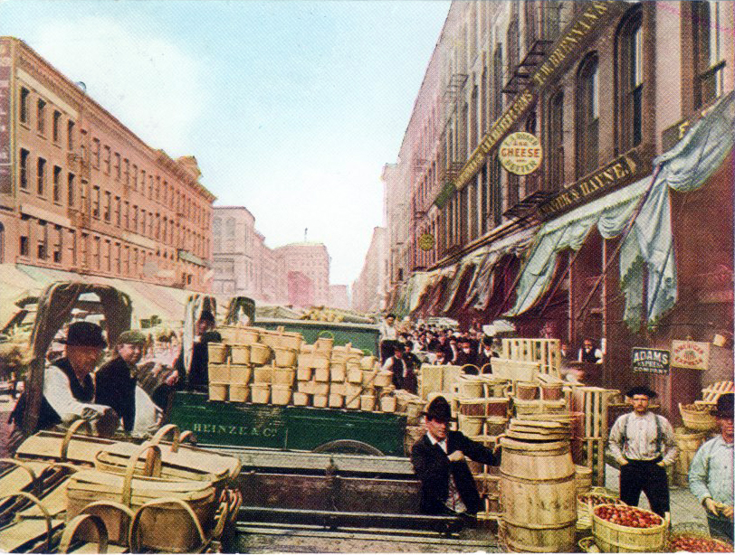
After the 1871 Chicago Fire, many offices that had once been near the river moved farther south into the expanding commercial downtown, and South Water Street (which is presently located just north of Lake Street between Wacker Drive & Stetson Drive) became home to the city's central produce market. It was fairly accessible to the rail yards and, most of all, was backed up to the docks where many incoming vessels could bring fruits and vegetables from the states located around the Great Lakes. Michigan was a great supplier during the warm months. Cherries, celery, apples, plums and other fresh commodities were put on boats from Benton Harbor, St. Joe, Ludington, Traverse City and other Michigan port cities and shipped to the South Water Market.
Note the wooden sidewalks and dirt roads. The wood planks on the left sidewalk were to cover up rain gutters and support delivery wagons.


By the turn of the century, reformers and planners, over the objections of some Chicagoans, urged that the gritty and heavily trafficked area be cleared out as an unsightly intrusion to the downtown that created unnecessary congestion in the heart of Chicago and blocked access to the river. In addition, the market had become too cramped for a city of Chicago's size.
As part of the building of bi-level Wacker Drive in the mid-1920s and the accompanying of a walkway along the riverfront, the city leveled the buildings in this area. It moved the wholesale produce business to the new South Water Market, bounded by Racine Avenue on the west, Morgan Street on the east, 14th Place on the north and the railroad on the south.
To make room for the new South Water Market, deteriorated existing houses were bulldozed in this high-crime neighborhood called The Village. In 1925, the approximate 13 acres of land and buildings cost around $17 million. It took 6 months to complete, and there were 166 stores or units. They designed the streets to be 10 feet wide and the alleys at 42 feet. It was expected that the new market would service Chicago well for at least the next 25 years. Soon it was discovered that the streets needed to be wider, and the market became severely crowded.

The time came again in 2003 for the market to move. The name changed to the Chicago International Produce Market, conveniently located off Damen and I-55. It is a state-of-the-art facility, and many merchants are the third or fourth generations in the family business.

Compiled by Dr. Neil Gale, Ph.D. 

Tuesday, April 17, 2018

The History of Moo & Oink Grocery Chain of Chicago, Illinois.

Moo & Oink was a southside Chicago-based grocery store chain and wholesaler that catered to the inner-city community and south suburbs.
Originally named the Calumet Meat Company, the company was renamed Moo & Oink in 1976. Moo & Oink had three stores in Chicago and one in Hazel Crest.
It became well known for its odd late-night television commercials that ran in the 1980s and mid-1990s, usually featuring dancing people in cow and pig costumes. The commercials often featured a jingle that started off with: "Moo and Oink! Moo Moo Moo!" and eventually ended with a famous sign-off, "Moooooooooooooo & Oink!"

MOO & OINK 1987 TV COMMERCIAL

The First Isle in Moo & Oink, 2004.
In 2005, Tina Fey and Amy Poehler sang the Moo and Oink jingle on the "Weekend Update" portion of Saturday Night Live to prove to Scott Podsednik that they were native Chicago White Sox fans.

MOO & OINK JINGLE

Moo & Oink is famous for its Chicago-style hot links and hand-cleaned chitlins. 

In April 2010, they revealed a new company logo, replacing the classic cartoonish cow and pig logo with an animated but realistic-looking animal logo. 
All Moo & Oink stores closed in 2011, after the company went into Chapter 7 bankruptcy, though there was interest in buying and resurrecting the company. By the end of the year, the brand and trademark were sold to Best Chicago Meat, and the stores remained unsold. 


Compiled by Dr. Neil Gale, Ph.D. 

Wednesday, April 4, 2018

Celebrating "Chicago Flag Day" on April 4th.

CHICAGO INCORPORATION DATA
James Thompson surveyed Chicago, filing the plat on August 4, 1830. This action was the official recognition of Chicago's location. 

Chicago was incorporated as a town on August 12, 1833, with a population of about 350. 

With a population of 4,170, the town of Chicago filed new Incorporation documents on March 4, 1837, becoming the City of Chicago and the world's fastest-growing city for several decades.

CHICAGO FLAG DESIGN EXPLAINED
In 1915, Chicago Mayor Carter Harrison, Jr., decided that the time had come for Chicago to join the dozens of other American municipalities that had adopted an official flag. The 1893 World's Columbian Exposition had come and gone with only a red banner emblazoned with a white pall (Y-shape) to advertise the city's "municipal colors" (the Y-shape would also be employed in the city's less recognizable "Municipal Device").


Harrison's flag commission received more than 1,000 proposals before settling on a design submitted by Wallace Rice, a lecturer in heraldry and flag history at the Art Institute of Chicago. Rice's original design only incorporated two stars, symbolizing the 1871 Chicago Fire and the 1893 World's Columbian Exposition.
Rice chose six-pointed stars to distinguish them from the five-pointed stars commonly seen on national flags; the points formed a 30-degree internal angle to mark them as distinct from the Star of David. He aligned them to the staff (left) side rather than centering them, assuming city officials might wish to add more stars later. 

The city did that in the 1930s, adding two more stars (symbolizing the 1933/34 Century of Progress Exposition and Fort Dearborn). There have been numerous campaigns to add a fifth star to honor everything from Chicago's role in creating the atomic bomb (Fermilab, Batavia, Illinois) to Chicago's history with the Special Olympics. 

The current form has remained unchanged since 1939.

Compiled by Dr. Neil Gale, Ph.D.